Shelltown, Maryland

Last updated
Shelltown, Maryland
Unincorporated community
USA Maryland location map.svg
Red pog.svg
Shelltown
Coordinates: 37°58′47″N75°38′24″W / 37.97972°N 75.64000°W / 37.97972; -75.64000 Coordinates: 37°58′47″N75°38′24″W / 37.97972°N 75.64000°W / 37.97972; -75.64000
Country Flag of the United States.svg United States
State Flag of Maryland.svg  Maryland
County Flag of Somerset County, Maryland.svg Somerset
Elevation 0.9 m (3 ft)
Time zone UTC-5 (Eastern (EST))
  Summer (DST) UTC-4 (EDT)
ZIP code 21838
Area code(s) 410, 443, and 667
GNIS feature ID 591269 [1]

Shelltown is an unincorporated community in Somerset County, Maryland, United States. [1] It is near the mouth of the Pocomoke River and takes its name from the abundant number of oysters, crabs, and other assorted crustaceans in the area.

Unincorporated area Region of land not governed by own local government

In law, an unincorporated area is a region of land that is not governed by a local municipal corporation; similarly an unincorporated community is a settlement that is not governed by its own local municipal corporation, but rather is administered as part of larger administrative divisions, such as a township, parish, borough, county, city, canton, state, province or country. Occasionally, municipalities dissolve or disincorporate, which may happen if they become fiscally insolvent, and services become the responsibility of a higher administration. Widespread unincorporated communities and areas are a distinguishing feature of the United States and Canada. In most other countries of the world, there are either no unincorporated areas at all, or these are very rare; typically remote, outlying, sparsely populated or uninhabited areas.

Somerset County, Maryland county in Maryland, United States

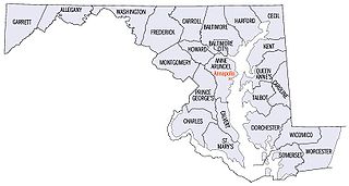
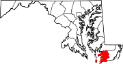
Somerset County is the southernmost county in the U.S. state of Maryland. As of the 2010 census, the population was 26,470. making it the second-least populous county in Maryland. The county seat is Princess Anne.

Maryland State of the United States of America

Maryland is a state in the Mid-Atlantic region of the United States, bordering Virginia, West Virginia, and the District of Columbia to its south and west; Pennsylvania to its north; and Delaware to its east. The state's largest city is Baltimore, and its capital is Annapolis. Among its occasional nicknames are Old Line State, the Free State, and the Chesapeake Bay State. It is named after the English queen Henrietta Maria, known in England as Queen Mary.

Shelltown is accessible from Shelltown Road, which connects to Old Rehobeth Road and Coventry Parish Road, both leading to Maryland Route 667.

Maryland Route 667 highway in Maryland

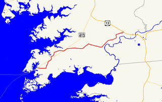
Maryland Route 667 is a state highway in the U.S. state of Maryland. The highway runs 17.61 miles (28.34 km) from Chesapeake Avenue in Crisfield east to U.S. Route 13 in West Pocomoke. MD 667 forms the old alignment of MD 413 from Crisfield to Hudson Corner in southern Somerset County. The highway has a curvaceously course through the villages of Hopewell and Marion Station while MD 413 passes them on a straight course. The portion of MD 667 between Hudson Corner and West Pocomoke serves the community of Rehobeth. This segment, which was built as Maryland Route 406, serves as a shortcut allowing traffic between Crisfield and Pocomoke City to avoid Westover at the junction of MD 413 and US 13. Portions of MD 667 are part of the Beach to Bay Indian Trail.

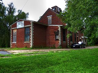
Reward was listed on the National Register of Historic Places in 1974. [2]

Reward (Shelltown, Maryland)

Reward, also known as Williams Point Farm, is a historic home located at Shelltown, Somerset County, Maryland, United States. It is a ​1 12-story, gable-front brick dwelling with a steep gable roof with two diamond-shaped chimney stacks piercing the east slope of the roof. The main block is constructed of whitewashed brick laid in Flemish bond.

National Register of Historic Places federal list of historic sites in the United States

The National Register of Historic Places (NRHP) is the United States federal government's official list of districts, sites, buildings, structures, and objects deemed worthy of preservation for their historical significance. A property listed in the National Register, or located within a National Register Historic District, may qualify for tax incentives derived from the total value of expenses incurred preserving the property.

Related Research Articles

White Plains, Maryland Unincorporated community in Maryland, United States

White Plains is an unincorporated community located in Charles County, Maryland, in the United States, just south of Waldorf. It is located at latitude 38°35'25" North; longitude 76°56'26" West. The United States Postal Service has assigned White Plains the ZIP Code 20695. While the commercial portion of White Plains lies along U.S. Route 301, the largest concentration of residences with the White Plains mailing address is actually six to seven miles to the west in developments located near Billingsley Road. The area is experiencing population sprawl from the adjacent unincorporated communities of Waldorf and St. Charles, features new office parks and a scenic new rail trail. The Charles County Department of Health is headquartered in White Plains, and a public golf course is also located there. Plans to complete an east-west connector road in the area were mired in controversy because of alleged adverse effects on the environment.

National Register of Historic Places listings in Maryland Wikimedia list article

There are more than 1,500 properties and districts listed on the National Register of Historic Places in the U.S. State of Maryland. Each of the state's 23 counties and its one county-equivalent has at least 20 listings on the National Register.

National Register of Historic Places listings in Prince Georges County, Maryland Wikimedia list article

This is a list of the National Register of Historic Places listings in Prince George's County, Maryland.

National Register of Historic Places listings in Harford County, Maryland Wikimedia list article

This is a list of the National Register of Historic Places listings in Harford County, Maryland.

National Register of Historic Places listings in Wicomico County, Maryland Wikimedia list article

This is a list of the National Register of Historic Places listings in Wicomico County, Maryland.

Upper Fairmount, Maryland Unincorporated community in Maryland, United States

Upper Fairmount is an unincorporated community in Somerset County, Maryland, United States. It is located at the intersection of Maryland Route 361 and Upper Hill Road. The Academy Grove Historic District, Maddux House, Schoolridge Farm, Tudor Hall, and Upper Fairmount Historic District are listed on the National Register of Historic Places.

Manokin, Maryland Unincorporated community in Maryland, United States

Manokin is an unincorporated community in Somerset County, Maryland, United States. It is located on Maryland Route 361 at the intersection of River Road. The George Maddox Farm, Sudler's Conclusion and Waters' River are listed on the National Register of Historic Places.

Oriole, Maryland Unincorporated community in Maryland, United States

Oriole is an unincorporated community in Somerset County, Maryland, United States. Oriole is located at the intersection of Maryland Route 627 and Jerusalem Road west of Princess Anne. The William S. Smith House was listed on the National Register of Historic Places in 1991. Coincidentally, the name is shared with the state's MLB team name, the Baltimore Orioles.

Wenona, Maryland Unincorporated community in Maryland, United States

Wenona is an unincorporated community located on Deal Island in Somerset County, Maryland, United States. It is located at the western end of Maryland Route 363, Deal Island Road.

Venton, Maryland Unincorporated community in Maryland, United States

Venton is an unincorporated community in Somerset County, Maryland, United States.

Cokesbury, Maryland Unincorporated community in Maryland, United States

Cokesbury is an unincorporated community in Somerset County, Maryland, United States. It is east of U.S. Route 13 near the Pocomoke River, at the intersection of Wallace Taylor Road, Cokesbury Road, and Courthouse Hill Road. Burton Cannon House was listed on the National Register of Historic Places in 1975.

Wittman, Maryland Unincorporated community in Maryland, United States

Wittman is an unincorporated community in Talbot County, Maryland, United States. Wittman is located at the intersection of Pot Pie Road, New Road, and Cummings Road south of Claiborne. Although it is unincorporated, it has a post office, with the ZIP code of 21676. The Flying Cloud was listed on the National Register of Historic Places in 1985.

Mutual, or Mutual Consent, is an unincorporated community located at the crossroads of MD 264, MD 265, Ball Road, Grays Road, and Laveille Road in Calvert County, Maryland, United States. La Veille was listed on the National Register of Historic Places in 1973.

Parran, Maryland Unincorporated community in Maryland, United States

Parran is an unincorporated community located at the crossroads of MD 263, Cox Road, and Emmanuel Church Road in Calvert County, Maryland, United States. Cornehill was listed on the National Register of Historic Places in 1973.

Rocky Ridge, Maryland Unincorporated community in Maryland

Rocky Ridge is an unincorporated community in Frederick County, Maryland, United States. The name "Rocky Ridge" likely refers to a ridge of ironstone which runs through the area.

Unionville, Frederick County, Maryland Unincorporated community in Maryland, United States

Unionville is an unincorporated community in Frederick County, Maryland, United States. It is located approximately halfway between Frederick and Westminster, just east of Libertytown off Maryland Route 26. The Pearre-Metcalfe House, which sits on Albaugh Road, just outside the town's center, was listed on the National Register of Historic Places in 1979.

Jerusalem, Maryland Unincorporated community in Maryland, United States

Jerusalem is an unincorporated community in Harford County, Maryland, United States. It is the location of the historic Jerusalem Mill Village and Jericho Covered Bridge, both listed on the National Register of Historic Places. Jerusalem Mill Village is located on Jerusalem Road in Kingsville, MD between the Little Gunpowder Falls river and Jericho Road.

Earleville, Maryland Unincorporated community in Maryland, United States

Earleville is an unincorporated community in Cecil County, Maryland, United States. Earleville is located at the intersection of Maryland Route 282 and Grove Neck Road west of Cecilton.

Ironshire, Maryland Unincorporated community in Maryland, United States

Ironshire is an unincorporated community in Worcester County, Maryland, United States. Ironshire is located at the intersection of U.S. Route 113 and Ironshire Station Road/Mason Road south of Berlin.

References

  1. 1 2 "Shelltown". Geographic Names Information System . United States Geological Survey.
  2. National Park Service (2010-07-09). "National Register Information System". National Register of Historic Places . National Park Service.