The Chesapeake Bay is the largest estuary in the United States. The Bay is located in the Mid-Atlantic region and is primarily separated from the Atlantic Ocean by the Delmarva Peninsula, including parts of the Eastern Shore of Maryland, the Eastern Shore of Virginia, and the state of Delaware. The mouth of the Bay at its southern point is located between Cape Henry and Cape Charles. With its northern portion in Maryland and the southern part in Virginia, the Chesapeake Bay is a very important feature for the ecology and economy of those two states, as well as others surrounding within its watershed. More than 150 major rivers and streams flow into the Bay's 64,299-square-mile (166,534 km2) drainage basin, which covers parts of six states, New York, Pennsylvania, Delaware, Maryland, Virginia, and West Virginia, and all of Washington, D.C.

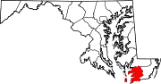
Crisfield is a city in Somerset County, Maryland, United States, located on the Tangier Sound, an arm of the Chesapeake Bay. The population was 2,515 at the 2020 census. It is included in the Salisbury, Maryland-Delaware Metropolitan Statistical Area. Crisfield has the distinction of being the southernmost incorporated city in Maryland.

Smith Island is a collection of three distinct island communities, Tylerton, Rhodes Point, and Ewell, Maryland on the Chesapeake Bay, on the border of Maryland and Virginia territorial waters in the United States. The island is the last inhabited island in Maryland that is not accessible by vehicle, where most of the islands are eroding due to tidal currents and sea level rise. A study conducted in 2008 by the DNR reported that Smith Island is expected to completely erode by 2100 if no action was taken.

Ocracoke is a census-designated place (CDP) and unincorporated town located at the southern end of Ocracoke Island, located entirely within Hyde County, North Carolina, United States. The population was 948 as of the 2010 census. In the 2020 census, the population had dropped to 797 people.

Tangier is a town in Accomack County, Virginia, United States, on Tangier Island in Chesapeake Bay. The population was 727 at the 2010 census. Since 1850, the island's landmass has been reduced by 67%. Under the mid-range sea level rise scenario, much of the remaining landmass is expected to be lost in the next 50 years and the town will likely need to be abandoned.

Barra is an island in the Outer Hebrides, Scotland, and the second southernmost inhabited island there, after the adjacent island of Vatersay to which it is connected by the Vatersay Causeway. The island is named after Saint Finbarr of Cork.

The Susquehanna River is a major river located in the Mid-Atlantic region of the United States, overlapping between the lower Northeast. At 444 miles (715 km) long, it is the longest river on the East Coast of the United States. By watershed area, it is the 16th-largest river in the United States, and also the longest river in the early 21st-century continental United States without commercial boat traffic.
Claiborne is an unincorporated community in Talbot County, Maryland, United States. The village is located on the eastern shore of the Chesapeake Bay near the mouth of the Eastern Bay at 38°50′15″N76°16′40″W, and uses ZIP code 21624. The 2000 U.S. Census listed the population as 147 and the number of homes as 84, slightly down from its 1941 population of 156. Between 1890 and 1930, the village was a busy port for passenger and then automobile ferry service across the Chesapeake Bay, with numerous stores and motels/resorts, including Maple Hall and the Bellfonte Hotel. A post office was added in 1893 and the Protestant Episcopal Church of Claiborne was built in 1898. In 1912, an elementary school and Methodist Church were added. Before 1912, students attended school in nearby McDaniel. The town's first school consisted of the kitchen of the local railroad pavilion, used as a classroom. In 1913, the town became home to the Claiborne Fresh Air Association, Inc., which was formed for the purpose of providing 10 weeks of fresh air and summer vacation for children who had been exposed to tuberculosis. The role of Claiborne as a terminal for cross-Bay ferries was diminished in 1930 when the primary route shifted to Matapeake in Kent Island. It ended altogether in 1938 when the direct connection from Annapolis to Claiborne was terminated and only an auxiliary shuttle between Claiborne and Romancoke on Kent Island remained. This shuttle service ended in 1952, a few months after the opening of the Chesapeake Bay Bridge; thus ending all ferry service to Claiborne after more than six decades.

The Eastern Shore of Virginia consists of two counties on the Atlantic coast detached from the mainland of the Commonwealth of Virginia in the United States. The 70-mile-long (110 km) region is part of the Delmarva Peninsula and is separated from the rest of Virginia by the Chesapeake Bay. Its population was 45,695 as of 2020.
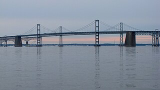
The Chesapeake Bay Bridge is a major dual-span bridge in the U.S. state of Maryland. Spanning the Chesapeake Bay, it connects the state's rural Eastern Shore region with the urban Western Shore, between Stevensville and the capital city of Annapolis. The original span, opened in 1952 and with a length of 4.3 miles (6.9 km), was the world's longest continuous over-water steel structure. The parallel span was added in 1973. The bridge is officially named the Gov. William Preston Lane Jr. Memorial Bridge after William Preston Lane Jr. who, as the 52nd Governor of Maryland, initiated its construction in the late 1940s finally after decades of political indecision and public controversy.

The Eastern Shore of Maryland is a part of the U.S. state of Maryland that lies mostly on the east side of the Chesapeake Bay. Nine counties are normally included in the region. The Eastern Shore is part of the larger Delmarva Peninsula that Maryland shares with Delaware and Virginia.

Maryland Public Television (MPT) is the Public Broadcasting Service (PBS) member state network for the U.S. state of Maryland. It operates under the auspices of the Maryland Public Broadcasting Commission, an agency of the Maryland state government that holds the licenses for all PBS member stations licensed in the state.

Kent Island is the largest island in the Chesapeake Bay and a historic place in Maryland. To the east, a narrow channel known as the Kent Narrows barely separates the island from the Delmarva Peninsula, and on the other side, the island is separated from Sandy Point, an area near Annapolis, by roughly four miles (6.4 km) of water. At only four miles wide, the main waterway of the bay is at its narrowest at this point and is spanned here by the Chesapeake Bay Bridge. The Chester River runs to the north of the island and empties into the Chesapeake Bay at Kent Island's Love Point. To the south of the island lies Eastern Bay. The United States Census Bureau reports that the island has 31.62 square miles (81.90 km2) of land area.
John Robert McCrum is an English writer and editor, holding senior editorial positions at Faber and Faber over seventeen years, followed by a long association with The Observer.
High Tider, Hoi Toider, or High Tide English is a dialect of Southern American English spoken in very limited communities of the South Atlantic United States, particularly several small island and coastal townships in the rural "Down East" region of North Carolina, which encompasses the Outer Banks and Pamlico Sound as well as in the Chesapeake Bay. High Tider dialect has been observed as far west as Bertie County, North Carolina. The term is also a local nickname for any native resident of these regions.

Maryland Route 33 is a state highway in the U.S. state of Maryland. The state highway runs 23.17 mi (37.29 km) from Tilghman Island east to Washington Street in Easton. MD 33 connects Easton, the county seat of Talbot County, with all communities on the peninsula that juts west into the Chesapeake Bay between the Miles River and Eastern Bay on the north and the Tred Avon River and Choptank River on the south. The state highway passes through the historic town of Saint Michaels, home of the Chesapeake Bay Maritime Museum, and enters Tilghman Island by passing over Knapps Narrows on the busiest bascule drawbridge in the United States.
The Story of English is an Emmy Award-winning nine-part television series, produced in 1986, detailing the development of the English language.

Holland Island was a marshy, rapidly eroding island in the Chesapeake Bay, in Dorchester County, Maryland, west of Salisbury. The island was once inhabited by watermen and farmers but has since been abandoned due to sinking of the land's surface associated with isostatic subsidence and sea level rise. It is located in the Holland Strait, between Bloodsworth Island and Smith Island, six miles west of Wenona, Maryland and Southeast of another former island, Long Island.

The Edna E. Lockwood is a Chesapeake Bay bugeye, the last working oyster boat of her kind. She is located at the Chesapeake Bay Maritime Museum in Saint Michaels, Maryland. She was built in 1889 at Tilghman Island, Maryland by John B. Harrison and is of nine-log construction, similar to the smaller log canoe, and was launched on October 5, 1889 for Daniel Haddaway, at a cost of $2,200. She worked for at least seven sets of owners from 1899 until 1967, and was then sailed as a yacht until donated to the museum in 1973. The museum undertook an extensive restoration of the Lockwood from 1975 through 1979, which restored the bugeye to its 1910 appearance with the "patent stern" that had been added sometime prior to that year. She is the last bugeye retaining the sailing rig and working appearance of the type. Her length is 53.5 feet (16.3 m), with a 15.25 feet (4.65 m) beam and a draft of 2.58 feet (0.79 m) with the centerboard up, and a maximum sail area of approximately 1700 square feet.

The Virginia Barrier Islands are a continuous chain of long, narrow, low-lying, sand and scrub barrier islands separated from one another by narrow inlets and from the mainland by a series of shallow marshy tidal bays along the entire coast of the Virginia end of the Delmarva Peninsula. Several of these islands were once significantly larger, covered with pine forests, and inhabited. After the completion of the New York, Philadelphia and Norfolk Railroad in the late 19th Century, at least five lavish hunting and fishing clubs were established on Virginia's barrier islands and they became a playground for wealthy sportsmen from Northeastern cities who would arrive by train. US President Grover Cleveland visited Hog Island to hunt waterfowl and go fishing in the early 1890s.