Somerset County is the southernmost county in the U.S. state of Maryland. As of the 2020 census, the population was 24,620, making it the second-least populous county in Maryland. The county seat is Princess Anne.

Odenton is a census-designated place (CDP) in Anne Arundel County, Maryland, United States, located approximately 10–20 minutes from the state capital, Annapolis. The population was 37,132 at the 2010 census, up from 20,534 at the 2000 census. The town's population growth rate of 80.8% between 2000 and 2010 was the greatest of any town in western Anne Arundel County. Odenton is located west of Annapolis, south of Baltimore, and northeast of Washington.

Shady Side is a census-designated place (CDP) in Anne Arundel County, Maryland, United States. The population was 5,803 at the 2010 census.

Woodlawn is an unincorporated community and census-designated place in Baltimore County, Maryland. Per the 2020 census, the population was 39,986. It is home to the headquarters of the Social Security Administration (SSA) and the Centers for Medicare and Medicaid Services (CMS). It is bordered by Catonsville on the south, by the Patapsco River and Howard County on the west, by Randallstown and Lochearn to the north, and by the City of Baltimore to the east. Parts of Woodlawn are sometimes informally referred to as Security, Maryland, due to the importance of the SSA's headquarters as well as nearby Security Boulevard and Security Square Mall.

Elkridge is an unincorporated community and census-designated place (CDP) in Howard County, Maryland, United States. The population was 15,593 at the 2010 census. Founded early in the 18th century, Elkridge is adjacent to two other counties, Anne Arundel and Baltimore.

Centreville is an incorporated town in Queen Anne's County, Maryland, United States on the Delmarva Peninsula. Incorporated in 1794, it is the county seat of Queen Anne's County. The population was 4,285 at the 2010 census. The ZIP code is 21617 and the area codes are 410 and 443. The primary local telephone exchange is 758. It hosts the Queen Anne's County Fair each summer and was home to three franchises during the existence of the Eastern Shore Baseball League—the Colts, Red Sox, and Orioles.

Crisfield is a city in Somerset County, Maryland, United States, located on the Tangier Sound, an arm of the Chesapeake Bay. The population was 2,515 at the 2020 census. It is included in the Salisbury, Maryland-Delaware Metropolitan Statistical Area. Crisfield has the distinction of being the southernmost incorporated city in Maryland.

Deal Island is a census-designated place (CDP) in Somerset County, Maryland, United States. The population was 375 at the 2020 census. It is included in the Salisbury, Maryland-Delaware Metropolitan Statistical Area. The small town was listed on the National Register of Historic Places as the Deal Island Historic District in 2006.
Princess Anne is a town in Somerset County, Maryland, United States, that also serves as its county seat. Its population was 3,290 at the 2010 census. It is included in the Salisbury, Maryland–Delaware Metropolitan Statistical Area.

Troutville is a town in Botetourt County, Virginia, United States. The population was 458 at the 2020 census. The town is located along the U.S. Route 11 between Cloverdale and Buchanan. It is part of the Roanoke Metropolitan Statistical Area.

Bowling Green is an incorporated town in Caroline County, Virginia, United States. The population was 1,111 at the 2010 census.

Kent Island is the largest island in the Chesapeake Bay and a historic place in Maryland. To the east, a narrow channel known as the Kent Narrows barely separates the island from the Delmarva Peninsula, and on the other side, the island is separated from Sandy Point, an area near Annapolis, by roughly four miles (6.4 km) of water. At only four miles wide, the main waterway of the bay is at its narrowest at this point and is spanned here by the Chesapeake Bay Bridge. The Chester River runs to the north of the island and empties into the Chesapeake Bay at Kent Island's Love Point. To the south of the island lies Eastern Bay. The United States Census Bureau reports that the island has 31.62 square miles (81.90 km2) of land area.

Griggstown is an unincorporated community and census-designated place (CDP) located within Franklin Township, in Somerset County, in the U.S. state of New Jersey. As of the 2010 United States Census, the CDP's population was 819. The area was first settled around 1733.

Blawenburg is an unincorporated community and census-designated place (CDP) located within Montgomery Township, in Somerset County, in the U.S. state of New Jersey. As of the 2010 United States Census, the CDP's population was 280. It is located at the juncture of two large roads, CR 518 and CR 601.
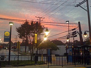
Lutherville is a census-designated place (CDP) in Baltimore County, Maryland, United States. As of the 2010 census it had a population of 6,504. Prior to 2010 the area was part of the Lutherville-Timonium CDP. Within its borders lies the Lutherville Historic District.
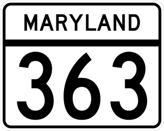
Maryland Route 363 (MD 363) is a state highway in the U.S. state of Maryland. Known for almost all of its length as Deal Island Road, the state highway runs 18.30 miles (29.45 km) from a dead end on Deal Island east to Mansion Avenue in Princess Anne. MD 363 connects Princess Anne and U.S. Route 13 (US 13) with the communities of Deal Island, Chance, and Dames Quarter on Tangier Sound in northwestern Somerset County. The state highway was constructed starting from Princess Anne around 1920, and reached Chance in the early 1930s. It was extended to Deal Island when a modern bridge to the island was constructed in 1940. MD 363 was extended to its present terminus on the island in the late 1950s.

Liberty Corner is an unincorporated community and census-designated place (CDP) located in Bernards Township, in Somerset County, in the U.S. state of New Jersey. Liberty Corner is about 3+3⁄4 miles (6.0 km) south of Bernardsville. Liberty Corner has a post office with ZIP code 07938. The Liberty Corner Historic District was listed on the state and national registers of historic places in 1991.
Kingston is an unincorporated community in Somerset County, Maryland, United States. A small community at the head of navigation of the Big Annemessex River, it is located on Maryland Route 413 at the intersection of Kingston Lane. A very rural community far from any urban development, it is quite small in population, the land dominated by agricultural fields and tree farms.
Oriole is an unincorporated community in Somerset County, Maryland, United States. Oriole is located at the intersection of Maryland Route 627 and Jerusalem Road, west of Princess Anne. The William S. Smith House was listed on the National Register of Historic Places in 1991.
Westover is an unincorporated community in Somerset County, Maryland, United States. It is located on Maryland Route 413 near its terminus at U.S. Route 13. Owing to its central location in Somerset County, Westover is home to many important services and businesses.