Elkridge is an unincorporated community and census-designated place (CDP) in Howard County, Maryland, United States. The population was 15,593 at the 2010 census. Founded early in the 18th century, Elkridge is adjacent to two other counties, Anne Arundel and Baltimore.

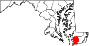
Crisfield is a city in Somerset County, Maryland, United States, located on the Tangier Sound, an arm of the Chesapeake Bay. The population was 2,515 at the 2020 census. It is included in the Salisbury, Maryland-Delaware Metropolitan Statistical Area. Crisfield has the distinction of being the southernmost incorporated city in Maryland.

Clarence is a town and affluent suburb located in the northeastern part of Erie County, New York, United States, northeast of Buffalo. The population was 32,950 according to the 2020 census estimate. This represents an increase of 7.4% from the 2010 census figure. The Clarence census-designated place occupies the southeast part of the town and roughly corresponds to a postal district with ZIP code 14031 and 14221 in the western side which it shares with nearby Williamsville. The town is named in honor of Prince William, Duke of Clarence and St Andrews (1765–1837), the third son of King George III and later king himself, as William IV.
Owens is a small unincorporated crossroads community at the intersection of Dahlgren Road, Windsor Drive, and Owens Drive in King George County, Virginia, United States. State Routes 206 and 218 meet at this intersection, with 206 going east towards U.S. Route 301 and Dahlgren, 218 going south towards US 301 and Colonial Beach and 206 and 218 joined together going west towards Arnolds Corner and Fredericksburg. The eastern part of the community is within the Dahlgren census-designated place.

Butler is an unincorporated community in Baltimore County, Maryland, United States. It is bordered to the west by Glyndon, to the east by Sparks, to the south by Cockeysville and to the north by Upperco. It is often referred to as "Worthington Valley". For almost a century, Butler has served as home to many equestrian events, including the Grand Nationals and the Hunt Cup.
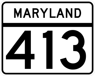
Maryland Route 413 is a 14.61-mile (23.51 km) state highway in Somerset County in the U.S. state of Maryland. The route runs from a dead end at Crisfield's city dock, which is located on the Tangier Sound, northeast to U.S. Route 13 in Westover. It is the main highway leading into Crisfield, and is known as Crisfield Highway for much of its length. The highway travels through mostly rural areas of farms and woods as well as the communities of Hopewell, Marion Station, and Kingston. It is a two-lane undivided road for most of its length; a portion of the road in Crisfield is a four-lane road that follows a one-way pair. MD 413 is part of two scenic routes: Chesapeake Country Scenic Byway and the Beach to Bay Indian Trail; both are Maryland Scenic Byways.
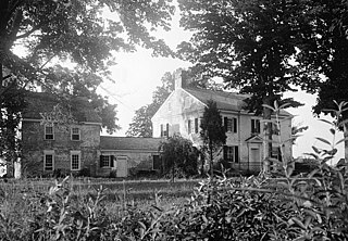
Kingston Hall is a historic home located at Kingston, Somerset County, Maryland. Located along the Big Annemessex River, it is a Georgian style dwelling of two stories plus an attic, three bays wide by two deep, connected by a one-story brick hyphen to a two-story-plus-loft brick kitchen wing. Also on the property is the brick, circular ice house. The interior of the house features corner fireplaces. Interior woodwork mouldings are in a transitional style, bridging late Georgian and Federal styles.

Upper Fairmount is an unincorporated community in Somerset County, Maryland, United States. It is located at the intersection of Maryland Route 361 and Upper Hill Road. The Academy Grove Historic District, Maddux House, Schoolridge Farm, Tudor Hall, and Upper Fairmount Historic District are listed on the National Register of Historic Places.
Kingston is an unincorporated community in Somerset County, Maryland, United States. A small community at the head of navigation of the Big Annemessex River, it is located on Maryland Route 413 at the intersection of Kingston Lane. A very rural community far from any urban development, it is quite small in population, the land dominated by agricultural fields and tree farms.
Marion Station, also known as Marion, is an unincorporated community in Somerset County, Maryland, United States. It is located at the northern intersection of Maryland routes 413 and 667. After the arrival of the Pennsylvania Railroad arm known as the "Eastern Shore Railroad" toward Crisfield in 1866, Marion was locally hailed as the "strawberry capital of the world". After the trains stopped coming it went into decline, with some sources even hailing it as a ghost town.
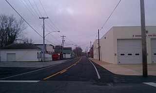
Westover is an unincorporated community in Somerset County, Maryland, United States. It is located on Maryland Route 413 near its terminus at U.S. Route 13. Owing to its central location in Somerset County, Westover is home to many important services and businesses.
Hopewell is an unincorporated community in Somerset County, Maryland, United States. It is located at the southern intersection of Maryland routes 413 and 667. St. Peter's Methodist Episcopal Church was listed on the National Register of Historic Places in 1990.

Creagerstown is an unincorporated community in Frederick County, Maryland, United States. It is playfully known by its residents as "4 miles from everywhere" because of its situation at 4 miles (6.4 km) from Thurmont, Woodsboro, Rocky Ridge, and Lewistown.

Four Corners is a neighborhood and census-designated place (CDP) in Montgomery County, Maryland, United States. Many residents consider the neighborhood a part of Silver Spring, to whose CDP it belonged until 2010. It had a population of 8,316 at the 2020 census.

Cloverhill is an unincorporated community located at the intersection of the boundaries of East Amwell and Raritan townships in Hunterdon County and Hillsborough Township in Somerset County, in New Jersey, United States. The Clover Hill Historic District was listed on the state and national registers of historic places in 1980.

Reaville is an unincorporated community located along the border of East Amwell and Raritan townships in Hunterdon County, New Jersey. By the 1830s, it was known as Greenville. It was later renamed after Runkle Rea, the first postmaster in 1850.

Wertsville is an unincorporated community located along County Route 602 in East Amwell Township of Hunterdon County, New Jersey, United States.
Hudson Corner is an unincorporated community in Somerset County, Maryland, United States. Hudson Corner is located at the intersection of Maryland Route 667 and Old Westover Marion Road, northeast of Marion Station.

Franklin Corners is an unincorporated community located along the Passaic River at the intersection of County Route 613 and U.S. Route 202 in Bernards Township of Somerset County, New Jersey. In the 19th century, it had a grist mill, saw mill, general store, school, and several houses. The Franklin Corners Historic District, featuring Van Dorn's Mill, was listed on the National Register of Historic Places in 1975.