Adjumani District

Last updated
Adjumani District
Adjumani District in Uganda.svg
District location in Uganda
Coordinates: 03°10′N31°47′E / 3.167°N 31.783°E / 3.167; 31.783
CountryFlag of Uganda.svg  Uganda
Region Northern Region
Sub-region West Nile sub-region
Capital Adjumani
Area
  Total3,030.9 km2 (1,170.2 sq mi)
Population
 (2012 Estimate)
  Total375,800
  Density124/km2 (320/sq mi)
Time zone UTC+3 (EAT)
Website www.adjumani.go.ug

Adjumani District is a district in Northern Uganda. Like most other Ugandan districts, it is named after its 'chief town', Adjumani, where the district headquarters are located.

Contents

Location

Adjumani District is bordered by Moyo District to the north, South Sudan to the northeast, Amuru District to the east and south, Arua District to the southwest and Yumbe District to the northwest. The largest town in the district, Adjumani, is located approximately 125 kilometres (78 mi), by road, northeast of Arua, the largest city in the sub-region. [1] This location lies approximately 436 kilometres (271 mi), by road, northwest of Kampala, the capital of Uganda and the largest city in that country. [2] The district lies on the southern bank of the White Nile, just before it flows into South Sudan. The coordinates of the district are:03 23N, 31 47E (Latitude:3.3845; Longitude:31.7820).

Overview

Adjumani District was created on May 17, 1997, when Moyo District was split into two. The eastern part of Moyo District was renamed Adjumani District, after its largest town, Adjumani. The western part of the old Moyo District, remained as the modern Moyo District.

In 1991, the national population census estimated the population of the district at about 96,300. The 2002 national census estimated the district population at about 202,300 people, of whom 49.6% were male and 50.4% were female. The annual district population growth rate has been determined to be 6.5%, between 2002 and 2012. It is estimated that the population of Adjumani District in 2019 was approximately 234,300. [3]

Since 1991, the district has been host to refugee settlements, including Baratuku, Mungula II and the Maaji refugee settlements, housing successive waves of people displaced from South Sudan. As of 2018, the district is home to over 236,000 refugees. [4] [5]

Economic activities

Agriculture is the backbone of Adjumani District's economy. Crops raised include

Prominent people

Prominent people from the district include the following:

Education

Primary schools

  • African Child Freedom Primary School
  • Agojo Lower Primary School
  • Ajeri Primary School
  • Alere 11 B Primary School
  • Alere I Primary School
  • Angel Garbiel Green Valley Primary School
  • Ayilo 11c Primary School
  • Ayilo Ii A Primary School
  • Bella Primary School
  • Biira Child Friendly Primary School
  • Bishop Angelo Ngrin Primary School
  • Bishop Ceaser Asili Primary School
  • Blessed Primary School
  • Christ The King Primary School
  • Ebenezer Primary School
  • Eden Junior School
  • Esia Primary School
  • Etia Primary School
  • Faith Primary School
  • F.K Onama Memorial Primary School
  • Gulinya Primary School
  • Gwere Primary School
  • Hero’s Foundation School
  • Homing Dove Primary School
  • Hope And Shine Primary School
  • Itoasi Primary School
  • Keyo III Primary School
  • Kobo Primary School
  • Kozeiza Primary School
  • Liberty Primary School
  • Liliane Foundation Primary School
  • Masa Primary School
  • Meabe II Primary School
  • Meabe I Primary School
  • Meabe Primary School
  • Meliaderi Primary School
  • Mijale Primary School
  • Mirieyi Primary School
  • Mirieyi Refugee Primary School
  • Moinya Primary School
  • Mother Thereza Preparatory School
  • Mummys Care Primary School
  • Mungula Primary School
  • New Generation Primary School
  • Nile Spring Junior School
  • Noor Islamic Primary School
  • Nyumanzi Alp Primary School
  • Ogolo Primary School
  • Ojigo Primary School
  • Oligo Primary School
  • Olua Primary School
  • Opejo Primary School
  • Opidolobo Primary School
  • Pagirinya I Primary School
  • Pagirinya Primary School
  • Peace Primary School
  • Pearl Demonstration Primary School
  • Rei Valley Sda Primary School
  • Rende Primary School
  • Robidire Primary School
  • Royal Primary School
  • Sir Samuel Mawa Primary School
  • St. Catherine Primary School
  • St. Dominic Nyabila Primary School
  • St. Dominic Savio Primary School
  • St. Egidio Primary School
  • St. James College Primary School
  • St. Joseph Primary School
  • St. Josephs Primary School
  • St. Luke Primary School
  • St. Luke Primary School
  • St. Mary Assumpta Primary School
  • St. Peter’s Primary School
  • St. Primos Primary School
  • St. Veronica Primary School
  • Tandala Primary School
  • Tianyu Primary School
  • Tuikat Hill Primary School
  • Twaheed Primary School
  • Umwia Primary School
  • West Gate Primary School
  • Yoro Town Primary School
  • Zoka Central Primary School
  • Zoka Primary School
  • Zoka South Primary School

Secondary schools

Radio stations in adjumani district

MHzStationtransmitting from * = exact site
89.10Radio AmaniAdjumani *
97.30Aulogo FMAdjumani *
99.70Radio UsalaamaPakele
103.80Aulogo FM

See also

Related Research Articles

<span class="mw-page-title-main">Moyo District</span> District in Northern Uganda, Uganda

Moyo District is a district in Northern Region of Uganda. Like many other Ugandan districts, it is named after its "chief town", Moyo, where the district headquarters are located.

<span class="mw-page-title-main">Yumbe District</span> District in Northern Uganda, Uganda

Yumbe District is a district in Northern Region, Uganda. Like most other Ugandan districts, it is named after its 'chief town', Yumbe, where the district headquarters are located.

<span class="mw-page-title-main">Koboko District</span> District in Northern Region of Uganda, Uganda

Koboko District is a district in the Northern Region of Uganda. The town of Koboko is the site of the district headquarters.

<span class="mw-page-title-main">West Nile sub-region</span>

West Nile sub-region, previously known as West Nile Province and West Nile District, is a sub-region in north-western Uganda, in the Northern Region of Uganda.

<span class="mw-page-title-main">Adjumani</span> Ugandan town

Adjumani is a town in the Northern Region of Uganda. It is the main municipal, administrative, and commercial centre of Adjumani District. The district is named after the town.

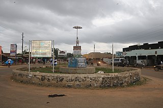
Moyo, is the main municipal, administrative, and commercial center of Moyo District in the Northern Region of Uganda. The district headquarters are located here.

Koboko is a town in Northern Region of Uganda. It is the main municipal, administrative, and commercial centre of Koboko District. Koboko is also the hometown of former dictator Idi Amin who ruled Uganda from 1971 to 1979.

Atiak is a town in the Northern Region of Uganda on the Gulu-Nimule Road, the primary trade route between Uganda and South Sudan.

Arua Regional Referral Hospital, commonly known as Arua Hospital is a hospital in the town of Arua, in Northern Uganda. It is the referral hospital for the districts of Adjumani, Arua, Koboko, Maracha, Moyo, Nebbi, Yumbe, and Zombo. The hospital also receives referrals from neighboring parts of South Sudan and the Democratic Republic of the Congo.

<span class="mw-page-title-main">Zombo District</span> District in Northern Uganda, Uganda

Zombo District is a district in the Northern Region of Uganda. The town of Zombo is the district's main municipal, administrative, and commercial center,

The Atiak–Adjumani–Moyo–Afonji Road is in the Northern Region of Uganda, connecting the towns of Atiak, Adjumani, Moyo, and Afoji at the international border with South Sudan.

Afoji is a town in Moyo District, in the Northern Region of Uganda.

The Koboko–Yumbe–Moyo Road is a road in the Northern Region of Uganda, connecting the towns of Koboko, Yumbe, and Moyo.

South Sudanese refugees are persons originating from the African country of South Sudan, but seeking refuge outside the borders of their native country. The world's youngest independent country has a recent and troubled history of prolonged conflicts and ecosystem mismanagement such as overlogging, which has led to desertification. These forces have resulted not only in violence and famine, but also the forced migration of large numbers of the population, both inside and outside the country's borders. South Sudan was cited as the largest refugee crisis in 2016, being the world's third largest, followed by Syria and Afghanistan. As of 2022, the UNHCR estimated that there were 2.4 million refugees under its mandate originating from South Sudan, making the country the fifth largest source of refugees.

<span class="mw-page-title-main">Rhino Camp Refugee Settlement</span> Refugee camp in Uganda

Rhino Camp Refugee Settlement is a refugee camp located in the districts of Madi-Okollo and Terego District in North Western Uganda.

Pagirinya Refugee Settlement is a refugee camp in Eastern Adjumani District in Northern Uganda.

<span class="mw-page-title-main">Jesca Ababiku</span> Ugandan educator and politician

Jesca Ababiku is a Ugandan educator and politician. She is currently a member of the Tenth Parliament of Uganda, representing the people of Adjumani district in one of the parliamentary seats reserved for women. She is a member of the National Resistance Movement (NRM), the ruling political party in Uganda under the chairmanship of Yoweri Kaguta Museveni Tibuhaburwa, the current president of the Republic of Uganda. In the 2021 Uganda general elections, Ababiku retained her seat as women member of parliament for Adjumani district.

Ayilo 2 refugee settlement is one of the refugee camps in Adjumani District in the Northern Region of Uganda.

<span class="mw-page-title-main">Maaji refugee settlements</span> Refugee camps in Adjumani District, Uganda

The Maaji refugee settlements are three refugee camps located in Adjumani District in the Northern Region of Uganda, established in 1997. In June 2018, there were 41,764 registered refugees, accounting for 10% of the district's total population. It has primarily admitted refugees from the Second Sudanese Civil War and the ongoing South Sudanese Civil War. The settlements have been attacked several times by the Lord's Resistance Army, along with other camps in the region such as the Baratuku refugee settlement.

Ayilo 1 refugee settlement is a prominent refugee camp located in Adjumani District, situated in the Northern Region of Uganda.

References

  1. "Road Distance Between Arua And Adjumani With Map". Globefeed.com. Retrieved 24 May 2014.
  2. "Map Showing Kampala And Adjumani With Distance Marker". Globefeed.com. Retrieved 24 May 2014.
  3. "Estimated Population of Adjumani District In 1991, 2002 & 2012". Citypopulation.de.
  4. UNHCR (June 2018). "Uganda Refugee Response Monitoring Settlement Fact Sheet: Baratuku". ReliefWeb. No. Uganda. Retrieved 22 May 2021.
  5. UNHCR (June 2018). "Uganda Refugee Response Monitoring Settlement Fact Sheet: Maaji". ReliefWeb. No. Uganda. Retrieved 2021-09-07.