Gulu District

Last updated

Gulu District
Acholi region
neucleated District
Gulu District in Uganda.svg
District location in Uganda
Coordinates: 02°45′N32°00′E / 2.750°N 32.000°E / 2.750; 32.000
CountryFlag of Uganda.svg  Uganda
Region Northern Region of Uganda
Sub-region Agago Acholi sub-region
Seat Gulu
Government
   LCV Chairman Ojara Martin Mapenduzi, 2011 - 2016
Area
  Total3,452.1 km2 (1,332.9 sq mi)
Population
 (2012 Estimate)
  Total396,500
  Density114.9/km2 (298/sq mi)
Time zone UTC+3 (EAT)
Website www.gulu.go.ug

Gulu is a district in the Northern Region of Uganda. The regional headquarters are located in the city of Gulu, which is also the administrative capital of Northern Uganda. the district consists of two main divisions, Gulu West and Gulu East.

Contents

Location

Gulu District is bordered by Lamwo District to the north, Pader District and Omoro District to the east, Oyam District to the south, Nwoya District to the southwest, and Amuru District to the west. The district headquarters in the city of Gulu are 333 kilometres (207 mi), by road, north of Uganda's capital city, Kampala. [1] The coordinates of the district are, near the city of Gulu are:02°49'50.0"N, 32°19'13.0"E (Latitude:2.830556; Longitude:32.320278). [2]

Overview

As of November 2019, the district was one of the eight districts that constituted the Acholi sub-region, the historical homeland of the Acholi ethnic group. The district is composed of Aswa County and the Gulu Municipal Council. The economic activity of 90 per cent of the population in the district is subsistence agriculture. [3]

The district has been the location of much of the fighting between the Ugandan army and the Lord's Resistance Army. Over 90 percent of the population has returned to their villages after more than two decades of living in what were known as "Internally Displaced People Camps". [4] [5]

Population

The national census conducted in 2002 put the population at 193,337. In the 2014 national census and household survey, the population of Gulu District was enumerated at 275,613. [6]


Related Research Articles

<span class="mw-page-title-main">Kitgum District</span> District in Northern Uganda, Uganda

Kitgum District is a district in Northern Uganda. It is named after its major town of Kitgum, where the district headquarters is located. It has suffered much fatalities and social disruption resulting from the 20-year civil war in the region during the late 20th century. The government moved tens of thousands of residents to internally displaced persons camps for their protection, where they were subject to raids by the rebels and also harsh conditions, including disease.

<span class="mw-page-title-main">Pader District</span> District in Northern Uganda, Uganda

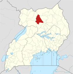
Pader District is a district in Northern Uganda. It is named after Pader, the chief municipal, administrative and commercial town in the district, where the district headquarters are located.

<span class="mw-page-title-main">Lira, Uganda</span> Place in Northern Region of Uganda, Uganda

Lira is a city in the Northern Region of Uganda. It is the main municipal, administrative, and commercial centre of Lira District.

<span class="mw-page-title-main">Gulu</span> City in northern Uganda

Gulu is a city in the Northern Region of Uganda. It is the commercial and administrative centre of Gulu District.

<span class="mw-page-title-main">Arua</span> Place in Northern Region, Uganda

Arua is a city and commercial centre within the Arua District in the Northern Region of Uganda.

<span class="mw-page-title-main">Apac</span> Ugandan town

Apac is a town in Apac District in the Northern Region of Uganda. It is the 'chief town' of the district and the district headquarters are located there. The district is named after the town.

Kitgum is a municipality in Kitgum District in the Northern Region of Uganda. The town is administered by Kitgum Municipality Council, an urban local government. It is the largest metropolitan area in the district and the site of the district headquarters.

<span class="mw-page-title-main">St. Mary's Hospital Lacor</span> Private community hospital in Uganda

St. Mary's Hospital Lacor, commonly referred to as Lacor Hospital, is a hospital in Gulu District, Northern Uganda. It was founded by Comboni Missionaries and is administered and managed by Roman Catholic Archdiocese of Gulu.

Bombo is a town in Luweero District in the Central Region of Uganda.

Atiak is a town in the Northern Region of Uganda on the Gulu-Nimule Road, the primary trade route between Uganda and South Sudan.

Pader is a town in Pader District in the Northern Region of Uganda. The town is administered by the Pader Town Council, an urban local government. It is the largest metropolitan area in the district and the site of the district headquarters.

<span class="mw-page-title-main">Amuru District</span> District in Northern Uganda, Uganda

Amuru District is a district in Northern Uganda. Like most Ugandan districts, it is named after its 'chief town', Amuru, where the district headquarters are located.

<span class="mw-page-title-main">Pabbo</span> Municipality in Northern Region of Uganda, Uganda

Pabbo, sometimes spelled as Pabo, is a municipality in Amuru District of the Northern Region of Uganda.

Anaka is a town in the Northern Region of Uganda. It is the site of the Nwoya District headquarters.

<span class="mw-page-title-main">Nwoya District</span> District in Northern Uganda, Uganda

Nwoya District is a district in Northern Uganda. Like most districts in Uganda, it is named after its main municipal, administrative and commercial center, Nwoya, the location of the district headquarters.

Nwoya is a town in Nwoya District in the Acholi sub-region, in the Northern Region of Uganda. It is the main municipal, administrative, and commercial centre of the district. Nwoya Town Council is classified as a municipality.

<span class="mw-page-title-main">Lamwo District</span> District in Northern Region of Uganda, Uganda

Lamwo District is a district in the Northern Region of Uganda. The town of Lamwo is the site of the district headquarters.

<span class="mw-page-title-main">Agago District</span> District in Northern Uganda, Uganda

The Agago District is a Ugandan district located in the Northern Region of Uganda.

Amuru is a town in the Northern Region of Uganda. It is the main municipal, administrative, and commercial centre of Amuru District.

Omoro District is a district in the Northern Region of Uganda.

References

  1. "Distance between Kampala, Uganda and Gulu, Uganda". Globefeed.com. 26 November 2019. Retrieved 26 November 2019.
  2. Google (26 November 2019). "Location of Gulu District, Northern Region, Uganda" (Map). Google Maps . Google. Retrieved 26 November 2019.
  3. "Overview of Gulu District". Kampala: Uganda Travel Guide. 2019. Retrieved 26 November 2019.
  4. Branch, Adam (2013). "Gulu in War ... and Peace? The Town as Camp in Northern Uganda". Urban Studies. 50 (15): 3152–3167. doi:10.1177/0042098013487777. ISSN   0042-0980. JSTOR   26145651.
  5. "Two decades of conflict take toll on northern Uganda | MSF". Médecins Sans Frontières (MSF) International. Retrieved 13 February 2022.
  6. Uganda Bureau of Statistics (11 March 2019). "Population of Gulu District In 2002 & 2014". Kampala: Citypopulation.de. Retrieved 26 November 2019.