Nugal, traditionally known as Nugaaleed-Bari or Bari-Nugaal meaning eastern Nugaal, or Nugaal xaggeeda hoose meaning lower Nugaal, is an administrative region (gobol) in northern Somalia.

Lower Shabelle is an administrative region (gobol) in southern Somalia.

North Kivu is a province bordering Lake Kivu in the eastern Democratic Republic of the Congo. Its capital is Goma.

Central Macedonia is one of the thirteen administrative regions of Greece, consisting of the central part of the geographical and historical region of Macedonia. With a population of almost 1.8 million, it is the second most populous region in Greece after Attica.

Eastern Macedonia and Thrace is one of the thirteen administrative regions of Greece. It consists of the northeastern parts of the country, comprising the eastern part of the region of Macedonia along with the region of Western Thrace, and the islands of Thasos and Samothrace.

The North Aegean Region is one of the thirteen administrative regions of Greece, and the smallest of the thirteen by population. It comprises the islands of the north-eastern Aegean Sea, called the North Aegean islands, except for Thasos and Samothrace, which belong to the Greek region of Eastern Macedonia and Thrace, and Imbros and Tenedos, which belong to Turkey.

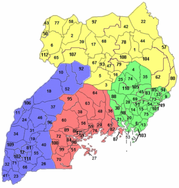
As of 1 July 2020, Uganda is divided into 135 districts plus the capital city of Kampala, which are grouped into four administrative regions.

The Gao Region is a region in northeastern Mali. The capital city is Gao.

Ghanzi is a district in western Botswana, bordering Namibia in the west and extending east into much of the interior of the country. The district's administrative centre is the town of Ghanzi. Most of the eastern half of Ghanzi makes up the Central Kalahari Game Reserve. The human population at the 2001 census was 43,370, less populous than that of any other district in Botswana. Ghanzi's area is 117,910 km².

The District of Gjilan is one of the seven districts of Kosovo. Its seat is in the city of Gjilan.
Thailand is variably divided into different sets of regions, the most notable of which are the six-region grouping used in geographic studies, and the four-region grouping consistent with the Monthon administrative regional grouping system formerly used by the Ministry of Interior. These regions are the largest subdivisions of the country.
The Northern Region is one of four regions in Uganda. As of Uganda's 2014 census, the region's population was 7,188,139.

Central Greece is one of the thirteen administrative regions of Greece. The region occupies the eastern part of the traditional region of Central Greece, including the island of Euboea. To the south it borders the regions of Attica and the Peloponnese, to the west the region of West Greece and to the north the regions of Thessaly and Epirus. Its capital city is Lamia.

The following outline is provided as an overview and topical guide to Gabon :
The Central region is one of the four regions in the country of Uganda. As of Uganda's 2014 census, the region's population was 9,529,227. It is coterminous with the Kingdom of Buganda, one of the ancient African monarchies that are constitutionally recognised in Uganda.
The Western Region of Uganda is one of four regions in the country of Uganda. As of Uganda's 2014 census, the Western region's population was 8,874,862.
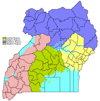
The regions of Uganda are known as Central, Western, Eastern, and Northern. These four regions are in turn divided into districts. There were 56 districts in 2002, which expanded into 111 districts plus one city (Kampala) by 2010.

Attica is an administrative region of Greece, that encompasses the entire Athens metropolitan area, the core city of which is the country's capital and largest city, Athens. The region is coextensive with the former Attica Prefecture of Central Greece and covers a greater area than the historical region of Attica.

The Southern and Eastern Serbia is one of five statistical regions of Serbia. It is also a level-2 statistical region according to the European NUTS. It was formed in 2010. As of 2022 census, the region has a total of 1,406,050 inhabitants.