Barreiras is a city located in the west of the state of Bahia, Brazil. It is the most important urban, political, technological and economic center of the western region of the state. Its economy is based on livestock raising and agriculture. In recent years it has experienced an economic boom and is one of the fastest-growing cities in the state of Bahia if not in Brazil.
Due to the hot climate in Barreiras, the Rio de Ondas is a tourist point very visited by bathers who seek to refresh themselves and enjoy the natural landscape.
Barreiras is located 853 kilometers from Salvador, the state capital, and 622 kilometers from Brasília, the federal capital. With a population of approximately 157 thousand inhabitants distributed over an area of 7,989km2, it is an important highway crossroads between the North, Northeast, and the Centerwest of the country. The main highway linking Brasília with Salvador – called BR 020 from Brasília to Barreiras and BR 242 from Barreiras to Salvador – passes through Barreiras. There is also an airport with daily flights to Brasília, Salvador de Bahia and São Paulo. There are no railway connections.
Geographically it is located in the basin of the Rio Grande, which flows north-east into the São Francisco River. Several other large rivers – the Rio de Janeiro, the Rio de Ondas, and the Rio Branco – pass through the municipality.
History
It is not known who founded Barreiras. There is no register of the first inhabitants, either European or Amerindian. The Acroás and Chacriabás were the tribes that lived along the banks of the Iassua, the name they gave to the Rio Grande. They soon disappeared either by disease or war. What is known is that there were some ranches, some as large as districts in Portugal.
Cattle caused the first settlers to penetrate these hostile regions, as the great herds began to advance into unexplored lands, bathed by rivers with clear waters. It was the São Francisco River that first brought explorers up to the vast interior. At the point where the Rio Grande flows into the São Francisco a small settlement called Barras took root. By 1600 adventurers had made their way up the Rio Grande as far as rocks that impeded their further passage. Below these rocks, "barreiras" in Portuguese, a small community began. The Rio Grande was navigable by small boats, and traders soon arrived in the region to support the cattle industry and the ranches. The village became an agricultural center producing tobacco, beans, corn and manioc. These were exported together with molasses, rum, manioc meal, and leather while European articles, kerosene and coffee were imported – all commerce being conducted by river.
By 1850 a cluster of huts supplied the boats that arrived on the river. It was called São João de Barreiras. By 1880 it was still only a village of twenty huts made of branches and adobe. The great abundance in the nearby forests of mangabeira, from whose sap rubber was made, was a factor for the growth of the town. The rubber was embarked down river to Salvador.
Ten more years of prosperity meant that in 1891 it became a district of the municipality of Angical. Then it became a vila in 1901, with the municipality being created with territory taken from Angical. Finally in 1902 it acquired the status of city, having at the time more than 630 houses and 2,500 inhabitants.
In 1928 the second hydroelectric station in Bahia was built in Barreiras. Industries began to come to the region. The city that had been practically stagnant for decades now had packing houses, rice and cotton mills, textile factories, and tanning factories. In 1943 a branch of Banco do Brasil opened its doors, the first bank in the city.
The good economic times of Barreiras lasted until 1964. In that year the power plant was closed and the city plunged into chaos. With no means of transport, since the rivers had ceased to be navigable and the airport had been closed, the city remained isolated for almost ten years until the Salvador/Brasília highway was finished. Soon after, the area received irrigation projects financed by the government, and the city began to develop again.
From the decade of the 1970s to the present, the municipality has gone from 20,864 inhabitants to 120,000 and undergone important transformations. It has received public and private investments that have modified the social and economic profile. After 1990 the intense agricultural activity has caused changes in practically all the economic and social sectors.
Barreiras is a major producer of cereals (soybeans and corn), coffee, cotton, and fruits, as well as cattle raising.
Irrigation, the level terrain, and the dry climate with well-defined dry and rainy seasons have made Barreiras a leader in agriculture. Much of the irrigation is done with central pivots.
Out of the 10,000 square kilometers total planted, soybeans represent 67%. 900 producers cultivate 6,900km2, producing 1.5 million tons, which represents 4.5% of the national production. The total planted area in 2003 was 1455.86km2. Other crops in planted area:
Barreiras has become an alternative area to coffee production in Brazil. After coffee was introduced eight years ago, the planted area has already surpassed 40.89km2. The region has a potential area of 1,000km2 for irrigated coffee, of which 500km2 have central pivots easily adapted to the planting of coffee. In the harvest of 2003 the production was 11,249 tons.
Irrigated fruit has reached excellent results and is competing in national and international markets. The main fruits are papaya, mango, lemons and oranges, guava, and coconut. Production not only supplies the national market but lemons, mangoes and papayas are exported to Europe and Canada. The planted area of the fruit is:
papaya: 5.3km2
mango: 1.2km2
coconut: 2.89km2
guava: 0.28km2
oranges: 1.33km2
lemon: 1.35km2
tangerine: 0.55km2
grapes: 0.05km2
Going along with the development of agriculture traditional cattle raising gave way in the 1990s to the use of high technology, with cultivated pastures in corrected areas; the raising of more productive breeds; maintenance of the herd with the use of mineral supplements; periodical vaccination and the use of modern techniques like embryo transfer and artificial insemination to improve the genetic quality; confinement and semi-confinement; the production of early heifers and pastures irrigated by pivot.
The bovine herd of the region is estimated in 55,215 head. Beef cattle make up 70% of the herd and the other 30% is dairy cattle.
The main breeds raised are: Nelore, Brown Swiss, Frisian, Limmousin, Chianina, Guzerá, Girolanda, Canchim, Marchigiana, Simental, Jersey and Santa Gertrudis.
Infrastructure
Barreiras has one retransmitting television station, three radio stations, and several newspapers. There are 27 post offices and 22 thousand telephone terminals installed. There are 194 schools in the school system and three post-secondary school colleges. There is a regional hospital with 168 beds.[citation needed]
The region is supplied by two hydroelectric plants, Correntina with capacity for 8,000kW and Alto das Fêmeas with capacity for 10,000kW, a network with 1,200 transmission lines, 19 substations and 85,547 urban and rural consumers.
Federal highway BR-242 links Barreiras eastward to the state capital of Salvador and westward to highway BR-020 at the town of Luís Eduardo Magalhães, from where one can go southwest to the national capital, Brasília, or northeast to Teresina and Fortaleza. The city is also served by Barreiras Airport(IATA: BRA, ICAO: SNBR), with regular scheduled lines to Salvador, Brasília and other Brazilian cities.
Tourist attractions
Acaba Vidas Waterfall - Formed by the Rio de Janeiro, with 36 meters of free fall, it is surrounded by an exuberant vegetation of ferns and secular trees and a constant mist.
Redondo Waterfall - paths with buriti palms and dense forest lead the visitor to this waterfall formed by the Rio de Janeiro. Its fall forms a great pool of crystalline waters.
Rio Grande - Crossing the city of Barreiras, it is the longest tributary on the left bank of the São Francisco. From the city there are 551 kilometers of navigable waters to Barra where it meets the São Francisco.
Rio de Janeiro - it is born in the municipality of Barreiras near the Serra Geral, and crosses savanna lands and valleys forming several pools and the waterfalls of Acaba Vidas and Redondo until it joins the Rio Branco.
Rio Branco - it is born near the Serra Geral in the municipality of Barreiras. It flows into the Rio Grande, some kilometers below the center of the city.
Rio de Ondas - with its clear waters it is one of the main recreation areas of the city. The most important clubs, resorts, and small farms are located on its banks. With rapids and waves that gave it its name it is much used by tourists who go down the river in canoes or tire tubes.
Goiás is a municipality in the state of Goiás in Brazil. Its population was 22,381 and its area is 3,108 km2. It is the former capital of the state and preserves much of its colonial heritage. In 2002, it became a UNESCO World Heritage Site.
Franca is a municipality in the state of São Paulo, Brazil. The city is located in the northeastern portion of the state, distant 401 km from the state capital, and 676 km from Brasilia. It covers a total area of 605,679 km2 of which 86,92 km2 comprises the urban area. As of the 2021 Census, the city's population was 358,539.
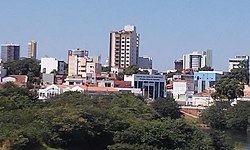
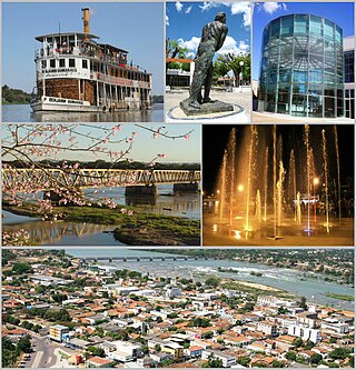
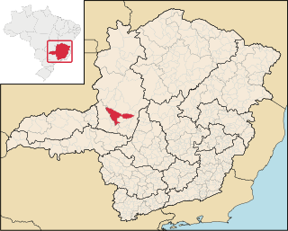
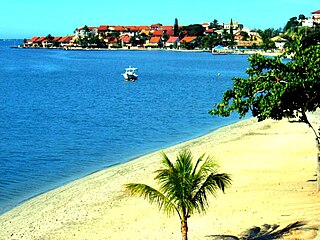
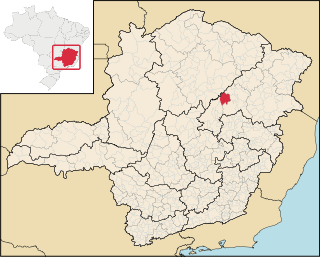
Pirapora is a municipality in northcentral Minas Gerais in Brazil. The population is 56,640 in an area of 550 km². The name Pirapora comes from the Tupi words for "fish" + "jump", referring to the piracema season when a mass migration of fishes ascends the São Francisco River to spawn.
Lages is a Brazilian municipality located in the central part of the state of Santa Catarina, in the region known in Portuguese as "Planalto Serrano".
Patos de Minas is a municipality in the state of Minas Gerais in Brazil.
Catalão is a city and municipality located in the south of the state of Goiás, in Brazil. It is a large producer of grains, cattle, and phosphates and has a John Deere and Mitsubishi factory.
Ipameri is a municipality and Latin Catholic bishopric in southeastern Goiás state, in Brazil. The population was 27,174 (2020) in a total area of 4,368.6 km2. It is a major producer of soybeans, corn and livestock.
Unaí is a municipality in the Northern Region of Minas Gerais, in the Brazilian state of Minas Gerais, in the Southeast Region of Brazil. It is located 590 km from the capital of Minas Gerais and 164 km from the federal capital. Unaí is the main municipality of its micro-region of the same name and, together with Paracatu, the most important city of the said mesoregion of Minas Gerais. Due to its geopolitical location, because it is geographically and politically linked to Brasilia and politically to Belo Horizonte, the municipality has a strong economic dynamism for a municipality that still carries the typically mineiro custom.
Arinos is a municipality in northern Minas Gerais state in Brazil. Arinos is located east of the Federal District on the Urucuia River, a major tributary of the São Francisco. The city is 333 km from Brasília.
Posse is a municipality in northeastern Goiás state, Brazil. It is located northeast of Brasília, 24 km from the state boundary with Bahia, on interstate highway BR-020 (Brasília-Salvador).
Barcelos, formerly Mariuá, is a municipality located in the State of Amazonas, northern Brazil. Its population was 27,638 (2020) and its area is 122,476 square kilometres (47,288 sq mi), making it the second largest municipality in Brazil, equivalent in size to New York state in the United States and slightly larger than North Korea.
Iguaba Grande is a municipality located in the Brazilian state of Rio de Janeiro. Its population was 28,837 (2020) and its area is 54 km².
Santa Vitória do Palmar is a Brazilian city and municipality. It is the southernmost municipality in Brazil, located in the state of Rio Grande do Sul. To the west of the municipality is the Lagoa Mirim and beyond that is Uruguay; to the east and southeast lies the Atlantic Ocean, and to the north is the city of Rio Grande. To the south, it borders the municipality of Chuí and Uruguay.
The climate in Brazil varies considerably from mostly tropical north to temperate zones south of the Tropic of Capricorn.
Araçuaí is a Brazilian municipality located in the northeast of the state of Minas Gerais in the Jequitinhonha River valley. The Araçuaí River, a tributary of the Jequitinhonha, flows through it. Its population as of 2020 was estimated to be 36,712 people living in a total area of 2,235 km2. The city belongs to the mesoregion of Jequitinhonha and the microregion of Araçuaí. The city is the seat of the Roman Catholic Diocese of Araçuaí. The elevation of the municipal seat is 307 meters. It became a municipality in 1870.
Bom Jesus is a municipality in the state of Rio Grande do Sul, Brazil. Its population was approximately 11,309 in 2020.
Encruzilhada do Sul is a municipality in the state of Rio Grande do Sul, Brazil.
Janaúba is a municipality in the north of the Brazilian state of Minas Gerais. In 2020 the population was 72,018 in a total area of 2,189 km2. The elevation is 692 meters above sea level.
Juramento is a municipality in the north of the Brazilian state of Minas Gerais. As of 2020 the population was 4,345 in a total area of 432 km2. It became a municipality in 1953.
Carbonita is a municipality in the northeast of the Brazilian state of Minas Gerais. As of 2020 the population was 9,414 in a total area of 1,454 km2. The elevation of the town center is 751 meters. It is part of the IBGE statistical meso-region of Jequitinhonha and the micro-region of Capelinha. It became a municipality in 1963.
↑ "Insolação Total (horas)". Normais Climatológicas do Brasil 1991-2020 (in Portuguese). Instituto Nacional de Meteorologia. Archived from the original on 24 March 2022. Retrieved 20 April 2024.
This page is based on this Wikipedia article Text is available under the CC BY-SA 4.0 license; additional terms may apply. Images, videos and audio are available under their respective licenses.