Santo Amaro, also known as Santo Amaro da Purificação is a municipality in the state of Bahia in Brazil. The population is 60,131 in an area of 492.9 square kilometres (190.3 sq mi). It is located in the metropolitan area of Salvador. Santo Amaro is located approximately 73 kilometres (45 mi) from the city of Salvador. Santo Amaro was home to numerous Amerindian peoples until the arrival of the Portuguese, who developed the region for sugarcane production. Santo Amaro is now noted for its numerous historic structures. The city is also a center of Candomblé, having more than 60 terreiros, or temples of the religion.

São Cristóvão is a Brazilian municipality in the Northeastern state of Sergipe. Founded at the mouth of the Vaza-Barris River on January 1, 1590, the municipality is the fourth oldest settlement in Brazil. São Cristóvão is noted for its historic city square, São Francisco Square, and numerous early colonial-period buildings. The 3 hectares site was designated a UNESCO World Heritage Site in 2010.

Itaparica is an island located at the entrance of Todos os Santos Bay on the coast of the Atlantic Ocean in the state of Bahia, Brazil. It is located about 10 kilometres (6.2 mi) from the city of Salvador, Bahia and covers 146 square kilometres (56 sq mi). There are two municipalities on the island: Vera Cruz and Itaparica (13%). Itaparica has 40 kilometres (25 mi) of beaches and exuberant tropical vegetation. Itaparica is the largest maritime island in Brazil.

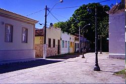
Cachoeira is an inland municipality of Bahia, Brazil, on the Paraguaçu River. The town exports sugar, cotton, and tobacco and is a thriving commercial and industrial centre.

The São Francisco Church and Convent of Salvador is located in the historical centre of Salvador, in the State of Bahia, Brazil. The ornate Church of the Third Order of Saint Francis sits adjacent to the convent. The friars of the Franciscan Order arrived in Salvador in 1587 and constructed a convent and church on the site. This structure was destroyed by the Dutch during the Dutch invasions of Bahia in the next century; Father Vicente das Chagas initiated the current structure in 1686, which was completed in the 18th century. The Franciscan church and convent have the largest number of azulejos, 55,000, of any church in Latin America.

The Historic Center (US) or Centre of Salvador de Bahia in Brazil, also known as the Pelourinho or Pelo, is a historic neighborhood in western Salvador, Bahia. It was the city's center during the Portuguese colonial period and was named for the whipping post in its central plaza where enslaved people from Africa were publicly beaten as punishment for alleged infractions. The Historic Center is extremely rich in historical monuments dating from the 17th through the 19th centuries.

São Francisco do Conde is a municipality in the state of Bahia in the North-East region of Brazil. São Francisco do Conde covers 262.856 km2 (101.489 sq mi), and has a population of 40,245 with a population density of 150 inhabitants per square kilometer. It is located 67 kilometres (42 mi) from the state capital of Salvador. According to the Brazilian Institute of Geography and Statistics São Francisco do Conde has the highest concentration of Brazilians of African descent (90%) in Bahia.
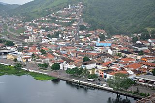
São Félix, Bahia is a municipality in Bahia, Brazil. The municipality has a population of 14,762 with a population density of 142 inhabitants per square kilometer. It is located 110 km (68 mi) from the state capital of Bahia, Salvador.

Cairu is a municipality in the state of Bahia in the North-East region of Brazil. The municipality has a population of 18,427 with a population density of 33.3 inhabitants per square kilometer. The municipality consists of three island: the Island of Cairu, which is only separated from the mainly by a narrow river; Tinharé Island, which has the dense tourist settlement of Morro de São Paulo to the north; and Boipeba Island.

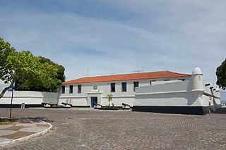
São Marcelo Fort, also known as Forte de Nossa Senhora do Pópulo e São Marcelo or Forte do Mar, is located in Salvador in Bahia, Brazil. It is located in small bit of land off the coast in the Baía de Todos os Santos. Standing on a small bank of reefs about 300 metres (980 ft) from the coast, it is one of two forts separated by water from land in Brazil, the other being the Fort Tamandaré da Laje Tamandaré in Rio de Janeiro. It is the only cylindrical fort in Brazil. Its design follows those of Castel Sant'Angelo in Italy and São Lourenço do Bugio Fort in Portugal. It is popularly known as the "Forte do Mar". It was built to protect the important port city Salvador from threats; the city had the largest number of forts during the colonial period of Brazil.
Maria Felipa de Oliveira was an Afro-Brazilian independence fighter from island of Itaparica, Bahia, active during the Brazilian War of Independence. The independence struggled against the Portuguese lasted a little over a year, with many battles centered on the Island of Itaparica. Maria Felipa is noted as one of three women who participated in the struggle for Bahia's independence in 1823, the others being the military figure Maria Quitéria (1792-1853) and Sister Joana Angélica (1761-1822).
Forte de São Lourenço is a fort located in Itaparica, Bahia in Brazil. It sits on a strategic point at the north of Itaparica Island on a site used for whaling in the early 17th century. The Dutch constructed a small earthwork fortification on the site during the Dutch occupation of Brazil (1630–1654); it was reconstructed by the Portuguese in its present form in the early 18th century. The fort was used by Brazilian forces during the Brazilian struggle for independence in 1823; the Brazilian Navy has owned the fort since the same year. The Forte de São Lourenço was listed as a federal historic structure in 1938.

The Chapel of Our Lady of Help is a 20th-century Roman Catholic church in Salvador, Bahia, Brazil. It sits on the site of a church of the same name built by the Jesuits in 1549, one of the first in Brazil. The present church was designed by the Italian architect Julio Conti in the Neo-Manueline style and consecrated in 1932. It is owned by the Roman Catholic Archdiocese of São Salvador da Bahia and houses numerous original works of art of the early colonial period. The Chapel of Our Lady of Help was listed as a historic structure by National Institute of Historic and Artistic Heritage (IPHAN) in 1938 and is part of the Historic Center of Salvador UNESCO World Heritage Site.

The Church of the Third Order of Mount Carmel is an 18th-century Roman Catholic church in Salvador, Bahia, Brazil. It is located adjacent to the Church and Convent of Our Lady of Mount Carmel. The Church of the Third Order of Mount Carmel was listed as a historic structure by National Institute of Historic and Artistic Heritage (IPHAN) in 1938 and is part of the Historic Center of Salvador UNESCO World Heritage Site.

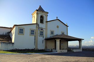
The Church of Saint Lawrence is a 17th-century Roman Catholic church located in Itaparica, Bahia, Brazil. The church is dedicated to Saint Lawrence, the patron saint of the island of Itaparica. It was built early in the Portuguese settlement of Brazil as part of the plantation of Gabriel Soares de Sousa. The Church of Saint Lawrence was listed as a historic structure by National Institute of Historic and Artistic Heritage (IPHAN) in 1952. 90% of the collection of religious objects and images were stolen from the church in 2010; they were never recovered.
The Church and Monastery of Our Lady of Monserrate is a 16th-century Roman Catholic church and monastery located in Salvador, Bahia, Brazil. The church and monastery are dedicated to Our Lady of Monserrate and belongs to the Roman Catholic Archdiocese of São Salvador da Bahia. It is located 200 metres (660 ft) from the Fort of Monserrate on a rock on the Itapagipe Peninsula. The date of construction of the structure is disputed; it dates to the 16th century, and has seen numerous alterations. The church was built either by the Spanish, or by the group that constructed the Garcia d'Ávila Tower House. Its design, along with that of numerous rural chapels of Bahia, is attributed to the Italian architect Baccio da Filicaia (1565-1628). The church interior was once lined entirely with 16th-century azulejos; now only a single strip of the tiles remain. The church was listed as a historic structure by the National Historic and Artistic Heritage Institute in 1958. It and the Chapel of Our Lady of the Ladder are the only remaining 16th-century chapels in Salvador.

The Church and Hospice of Our Lady of the Good Journey is an 18th-century Roman Catholic church located in Salvador, Bahia, Brazil. The church is dedicated to Our Lady of the Good Journey and belongs to the Roman Catholic Archdiocese of São Salvador da Bahia. It is located on the Itapagipe Peninsula and faces west directly onto the Bay of All Saints. The Church and Hospice of Our Lady of the Good Journey has a single tower with a frontispiece covered in blue and white azulejos in a zigzag pattern. It was listed as a historic structure by the National Historic and Artistic Heritage Institute (IPHAN) in 1938.

The Chapel of Our Lady of the Ladder is a 16th-century Roman Catholic church located in Salvador, Bahia, Brazil. It was constructed as part of the Nossa Senhora de Escada sugar plantation by Lázaro Arévolo, likely in 1566; he donated the chapel to the Jesuits in the late 16th century. The chapel is part of the Roman Catholic Archdiocese of São Salvador da Bahia; it was listed as a historic structure by the National Institute of Historic and Artistic Heritage (IPHAN) in 1962. It and the Church and Monastery of Our Lady of Monserrate are the only remaining 16th-century chapels in Salvador.

The Church and Convent of Our Lady of the Palm is a 17th-century Roman Catholic church in Salvador, Bahia, Brazil. The church is dedicated to Our Lady of the Palm and belongs to the Roman Catholic Archdiocese of São Salvador da Bahia. The church was established in 1830, and expanded to house members of the Order of Discalced Augustinians in Salvador and their missionaries from other Portuguese colonies. The church has a simple façade and a single bell tower. In contrast, the church has a richly decorated interior, with paintings, images, furniture, and religious implements from the 16th and 17th century. The Church and Convent of Our Lady of the Palm was listed as a historic structure by the National Institute of Historic and Artistic Heritage in 1938.

The Church of Saint Antony of Barra is a 17th-century Roman Catholic church in Salvador, Bahia, Brazil. It is one of three churches in Salvador dedicated to Saint Anthony of Padua and belongs to the Roman Catholic Archdiocese of São Salvador da Bahia. The church was likely founded in the 17th century on a point overlooking the Bay of All Saints. It features a simple Renaissance-style façade, nave, chancel, sacristy, and other rooms.