Iraquara

Last updated

Iraquara
City of Caves
Nickname: 
City of Caves
Bahia Municip Iraquara.svg
morro do chapeu localization map of the state ahia
CountryFlag of Brazil.svg  Brazil
Region Nordeste
State Bahia
MesoregionCentro Norte Baiano
Area
  Total309.010 sq mi (800.332 km2)
Population
 (2020 [1] )
  Total25,478
Time zone UTC−3 (BRT)
Website iraquara.ba.gov.br

Iraquara is a municipality in the state of Bahia in the North-East region of Brazil.

Contents

Geography

Its estimated in 2020 population was 25,478 inhabitants. It lies in the center of Bahia, in the Chapada Diamantina. Tourists visit to see the caves such as: Pratinha, Lapa Doce, Torrinha, Gruta Azul, Gruta da Fumaça, among others. [2] [3] [4] [5]

See also

Related Research Articles

Ibititá is a municipality in the state of Bahia in the North-East region of Brazil.

João Dourado is a municipality in the state of Bahia in the North-East region of Brazil.

Jussara, Bahia is a municipality in the state of Bahia in the North-East region of Brazil.

Lapão is a municipality in the state of Bahia in the North-East region of Brazil.

Mulungu do Morro is a municipality in the state of Bahia in the North-East region of Brazil.

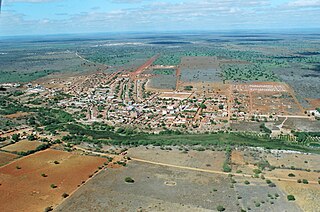
Presidente Dutra is a municipality in the state of Bahia in the North-East region of Brazil.

São Gabriel, Bahia is a municipality in the state of Bahia in the North-East region of Brazil.

Souto Soares is a municipality in the state of Bahia in the North-East region of Brazil.

<span class="mw-page-title-main">Ourolândia</span> Municipality in Nordeste, Brazil

Ourolândia is a municipality in the state of Bahia in the North-East region of Brazil.

Malhada de Pedras is a municipality in the state of Bahia in the North-East region of Brazil.

Piripá is a municipality in the state of Bahia in the North-East region of Brazil.

Presidente Jânio Quadros is a municipality in the state of Bahia in the North-East region of Brazil.

Tremedal is a municipality in the state of Bahia in the North-East region of Brazil.

Licínio de Almeida is a municipality in the state of Bahia in the North-East region of Brazil.

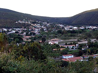
Mucugê is a municipality in the state of Bahia, in the North-East region of Brazil. It is close to the Chapada da Diamantina National Park.

<span class="mw-page-title-main">Palmeiras, Bahia</span> Municipality in Nordeste, Brazil

Palmeiras is a municipality in the state of Bahia in the North-East region of Brazil.

Utinga is a municipality in the state of Bahia in the North-East region of Brazil.

<span class="mw-page-title-main">Wagner, Bahia</span> Municipality in Nordeste, Brazil

Wagner is a municipality in the state of Bahia in the North-East region of Brazil.

Cândido Sales is a municipality in the state of Bahia in the North-East region of Brazil.

<span class="mw-page-title-main">Jaborandi, Bahia</span> Municipality in Nordeste, Brazil

Jaborandi, Bahia is a municipality in the state of Bahia in the North-East region of Brazil.

References

  1. IBGE 2020
  2. "Divisão Territorial do Brasil" (in Portuguese). Divisão Territorial do Brasil e Limites Territoriais, Instituto Brasileiro de Geografia e Estatística (IBGE). 1 July 2008. Retrieved 17 December 2009.
  3. "Estimativas da população para 1º de julho de 2009" (PDF) (in Portuguese). Estimativas de População, Instituto Brasileiro de Geografia e Estatística (IBGE). 14 August 2009. Retrieved 17 December 2009.
  4. "Ranking decrescente do IDH-M dos municípios do Brasil" (in Portuguese). Atlas do Desenvolvimento Humano, Programa das Nações Unidas para o Desenvolvimento (PNUD). 2000. Archived from the original on 3 October 2009. Retrieved 17 December 2009.
  5. "Produto Interno Bruto dos Municípios 2002–2005" (PDF) (in Portuguese). Instituto Brasileiro de Geografia e Estatística (IBGE). 19 December 2007. Archived from the original (PDF) on 2 October 2008. Retrieved 17 December 2009.

12°14′56″S41°37′08″W / 12.24889°S 41.61889°W / -12.24889; -41.61889