Bunker Hill, Los Angeles

Last updated

Bunker Hill
Los Angeles Downtown locator.PNG
Red pog.svg
Bunker Hill
Location within Downtown Los Angeles
Coordinates: 34°03′07″N118°15′01″W / 34.052035°N 118.250347°W / 34.052035; -118.250347
Country United States
State California
County Los Angeles
City Los Angeles
Named for Battle of Bunker Hill
Area code 213

Bunker Hill is a neighborhood in Los Angeles, California. It is part of Downtown Los Angeles.

Contents

Historically, Bunker Hill was a large hill that separated the Victorian-era Downtown from the western end of the city. The hill was tunneled through at Second Street in 1924, and at Third and Fourth Streets. [1] In the late 20th century, the hill was lowered in elevation, and the entire area was redeveloped to supplant old frame and concrete buildings with modern high-rises and other structures for residences, commerce, entertainment, and education. [2]

History

A view of Bunker Hill, 1900, with Pershing Square in the foreground Downtown-LA-1900.jpg
A view of Bunker Hill, 1900, with Pershing Square in the foreground

Early development

View of Angels Flight as it passes over Clay Street in 1955 Know Your City No.3 View down alleyway at Angels Flight car Los Angeles, Calif. 1955.jpg
View of Angels Flight as it passes over Clay Street in 1955

In 1867, two wealthy developers, Prudent Beaudry, a French-Canadian immigrant, and Stephen Mott purchased a majority of the hill's land. Beaudry's land purchase ranged from present-day Hill Street to Olive Street and 4th Street and 2nd Street. Mott's land purchase ranged between 4th Street to Temple and Figueroa and Grand. [3] Because of the hill's excellent views of the Los Angeles Basin and the Los Angeles River, he knew that it would make for an opulent subdivision. Beaudry employed surveyor George Hansen to help divide up the land into 80 plots to sell to individual buyers.[ citation needed ]

Beaudry started to build his house on the top of the hill, a modest two-story structure. He needed the infrastructure set up to reach the top of the hill, such as the water pipes. He asked the Los Angeles Water Company to help build the water pipe up the hill. Due to the nature of the hill and their initial concerns about the plan they denied his plea. As result, he built his own pipes and also formed the Canal and Reservoir Company [4] Several new streets were created, one of which—Bunker Hill Avenue, named in commemoration of the Battle of Bunker Hill—eventually gave its name to the new neighborhood. [5]

Beaudry developed the peak of Bunker Hill with lavish two-story Victorian houses that became famous as homes for the upper-class residents of Los Angeles. [6] The dominant architecture of the community of the houses of Bunker Hill was Queen Anne and Eastlake style. The geography of the Hill allowed these residents to escape the hustle and bustle of the city as it slowly grew around at the flatland at the bottom of the hill. Some notable residents [7] during these times are:

After the introduction of the horse carriage to the Bunker Hill neighborhood, the iconic Angel's Flight was proposed. Angel's Flight, now dubbed "The World's Shortest Railway", took residents homeward from the bottom of the 33% grade and down again. Colonel J. W. Eddy petitioned the Los Angeles City Council to establish an electric cable railway, which was approved ten days later signed by the mayor, Meredith P. Snyder. The first railways which was established and operational was on Third Street, from Hill Street to Olive Street. [8]

"Blighted Community"

Initially a residential suburb, Bunker Hill retained its exclusive character through the end of World War I. Around the 1920s and the 1930s, with the advent of the Pacific Electric Railway and the construction of the freeway, and the increased urban growth fed by an extensive streetcar system, its wealthy residents began leaving for enclaves such as Beverly Hills and Pasadena. Bunker Hill's houses were increasingly subdivided to accommodate renters. Bunker Hill was at this time "Los Angeles's most crowded and urban neighborhood". [9] By World War II, the Pasadena Freeway, built to bring shoppers downtown, was taking more residents out. Additional postwar freeway construction left downtown comparatively empty of both people and services. The once-grand Victorian mansions of Bunker Hill became the home of impoverished pensioners. [10] Over time, these tenements became more prominent, and apartment buildings started being built alongside these houses. As more and more people crowded into these cheap housing units, the population of the hill increased 19%, most of whom were low income. [11]

Bunker Hill Redevelopment Project

The demolition of the buildings around Angels Flight, 1962 Angels Flight is seen from south as buildings are razed in Los Angeles, Calif., 1962.jpg
The demolition of the buildings around Angels Flight, 1962
The Wells Fargo Center, One California Plaza and Two California Plaza, stands on the highest point of Bunker Hill. As seen from the top of the Westin Bonaventure Hotel. Wellscali.jpg
The Wells Fargo Center, One California Plaza and Two California Plaza, stands on the highest point of Bunker Hill. As seen from the top of the Westin Bonaventure Hotel.

In 1955, Los Angeles city planners decided that Bunker Hill required a massive slum clearance project. There were a couple of major political events which led to the "removal of the blight" and redevelopment of Bunker Hill. The California Community Redevelopment Law of 1945, the Federal Housing Act of 1946 and 1949, the creation of the Community Redevelopment Agency in 1948, and also the Bunker Hill Urban Renewal Project in 1959. [12]

The California Community Redevelopment law of 1945 allowed counties and cities to create and implement these agencies to help deal with the redevelopment of local cities. Until 2011, these Agencies held much power and were still around, until Governor Jerry Brown signed into law two bills to dissolve them. [13]

Along with those political factors, other things which led to the conclusion of the blighted neighborhood came from some of the government offices. The Los Angeles Police Department called the area a "high frequency crime area", due to the fact that the area's apartments catered to known offenders. The health department of Los Angeles also called the area a health hazard for its city. It wasn't until the CRA had won an ongoing court case against the residents of Bunker Hill. This loss for the residents of Bunker Hill led to the displacement of many families and removal of many of the low income residents of the area. [14] This victory for the CRA led to them being able to buy land to redevelop as they saw fit. Within the plans for the redevelopment, there was a section for the rehabilitation of the buildings of Bunker Hill. The section was slated to preserve the historical buildings of Bunker Hill, but instead were demolished since there was no actual rehabilitation planned. [15]

The development of Bunker Hill caused much controversy. The creation of the Public Works Administration and the 1949 U.S. Federal Housing Act helped quickly to clear and acquire the land on which "slum and blighted" areas of Downtown's Bunker Hill were situated. The city cleared the land and sold this land to private and public development according to the plan made by the CRA. [16]

John Ferraro Building, Bunker Hill, home to the Los Angeles Department of Water & Power JohnFerraroBuilding-122204.jpg
John Ferraro Building, Bunker Hill, home to the Los Angeles Department of Water & Power

The project is the longest redevelopment project in Los Angeles history. The majority of the skyscrapers on Bunker Hill were built in the 1980s, with a new skyscraper or two being finished nearly every year. However, the momentum died down in the 1990s, shortly after the 52-story Two California Plaza was finished. [17] In 1999, the vacancy rate for downtown commercial skyscrapers was 26%, one of the highest in the nation for that time. Planned office towers were canceled, including California Plaza Three. [18]

21st century adaptive re-use

Aerial view in 2014 Downtown-Los-Angeles-Aerial-view-from-south-August-2014.jpg
Aerial view in 2014

A sign of the success of the downtown renaissance was the lower office vacancy rate for the fourth quarter of 2004 at 16%, compared to 19% for 2003, and 26% for 1999. [19]

Affordable housing

While developers are primarily building market-rate housing on Bunker Hill today, Los Angeles has very strict laws, rules, and ordinances established that promote the inclusion of all income levels into the residential mix. Some examples include incentives for the creation of affordable housing (rather than market-rate housing), the preservation of existing affordable housing, the development of affordable housing by the city itself (rather than waiting for private developers), and others. The city has written documentation regarding the development of affordable housing. [20]

On the topic of building affordable housing for very low-income to moderate-income, Principal City Planner Jane Blumenfeld said, "We are trying to make it attractive to build [downtown] and get this added affordable housing that we normally wouldn't have. We need an adequate amount of lower income housing so that in 20 years Downtown doesn't become an exclusive neighborhood." [21]

The Emerson apartment building, owned by the Related Companies, has 271 units, of which 216 are leased at market rates. The other 55 units are at subsidized rates to tenants whose annual incomes are less than 50% of the local median, which was $42,700 for a family of four in 2014. [22]

Notable features

Library Steps

The 60-foot wide (18 m) double stairway public art installation Library Steps was designed by Lawrence Halprin in 1989. It physically and symbolically connects the main entrance of the Los Angeles Public Library at Fifth Street with Hope Place and the Kechum-Downtown YMCA to the north. The double stairs flank a cascading river rock "stream" that flows from the pool surrounding Robert Graham's 1992 public art sculpture Source Figure, and terminate at Fifth Street with a fountain element and seating. [23]

Angels Flight Railway

The 1901 Angels Flight funicular railway, originally connecting Hill Street and Olive Street immediately south of the east end of the 3rd Street Tunnel, was dismantled in 1969, relocated approximately 300 feet (91 m) further south and rebuilt in 1996 to connect Hill Street with California Plaza. [24]

Public venues

Walt Disney Concert Hall, Bunker Hill WaltDisneyConcertHall-12-22-04.jpg
Walt Disney Concert Hall, Bunker Hill

Contributing to the resurgence of Bunker Hill has been the construction of public venues, such as Walt Disney Concert Hall and the Museum of Contemporary Art.

The Broad modern art museum opened next to Disney Concert Hall on September 20, 2015. [25]

Angels Flight, December 2011 Angels Flight 2011.JPG
Angels Flight, December 2011

Video games

L.A. Noire, the 2011 Video Game set in 1947 Los Angeles, features a close recreation of the area in that period.

Film

In the 1940s and 1950s, Bunker Hill was a popular film setting, especially in the film noir genre, because of its Victorian homes, its rambling hillside apartments and flophouses, its Angels Flight funicular, and its mean (or at least mean-looking) streets. [26] [27] It was used extensively in such crime films as Cry Danger (1951), Kiss Me Deadly (1956), Criss Cross (1949), Joseph Losey's M (1951), and Angel's Flight (1965).

Director Curtis Hanson re-created Bunker Hill in another hilly neighborhood altogether in his Oscar Award–winning L.A. Confidential (1997). [28] [29] [30] Kent Mackenzie made a film in 1956 called Bunker Hill about the displacement of the residents who had to make way for construction. [31] [32] [33] Another film by Mackenzie that was set in the area —his neo-realist and semi-documentary feature The Exiles (1961) — depicts the lives of a tribe of urban Indians on Bunker Hill in the late 1950s. [34]

Books

Bunker Hill is the setting for much of Robin Robertson's 2018 verse narrative The Long Take which won the 2018 Goldsmiths Prize. [35] The book includes a map of the old Bunker Hill neighbourhood. Robertson discussed his fascination with the district on BBC Radio 4's The Film Programme in March 2019. [36]

Dreams from Bunker Hill (1982) is the last novel written by John Fante before his death. On April 8, 2010, the day of the 101st anniversary of the writer's birth, John Fante Square was inaugurated at the intersection of Fifth Street and Grand Avenue. [37]

Services

Fire Station 3 Downtown LAFD Station - 3.JPG
Fire Station 3 Downtown

Emergency services

The Los Angeles Police Department's Central Community Police Station serves Downtown Los Angeles, including Bunker Hill. [38]

The Los Angeles Fire Department's Central Bureau serves Downtown Los Angeles, including Bunker Hill. The LAFD operates Fire Station 3 (Civic Center/Bunker Hill) in the area. [39]

Education

The area is served by the Los Angeles Unified School District.

Notable people

See also

Related Research Articles

<span class="mw-page-title-main">Charlestown, Boston</span> Neighborhood in Boston, Massachusetts, United States

Charlestown is the oldest neighborhood in Boston, Massachusetts, in the United States. Also called Mishawum by the Massachusett, it is located on a peninsula north of the Charles River, across from downtown Boston, and also adjoins the Mystic River and Boston Harbor waterways. Charlestown was laid out in 1629 by engineer Thomas Graves, one of its earliest settlers, during the reign of Charles I of England. It was originally a separate town and the first capital of the Massachusetts Bay Colony.

<span class="mw-page-title-main">Angels Flight</span> Funicular railway in Los Angeles, California

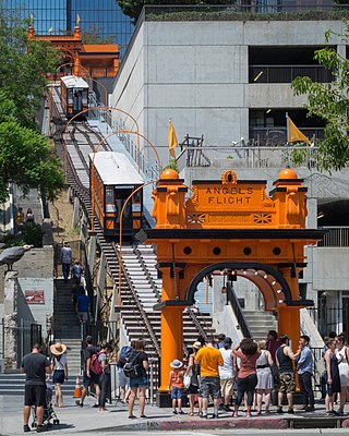
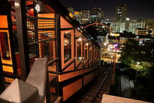
Angels Flight is a landmark and historic 2 ft 6 in narrow gauge funicular railway in the Bunker Hill district of Downtown Los Angeles, California. It has two funicular cars, named Olivet and Sinai, that run in opposite directions on a shared cable. The tracks cover a distance of 298 feet (91 m) over a vertical gain of 96 feet (29 m).

<span class="mw-page-title-main">Downtown Los Angeles</span> Neighborhood in Los Angeles, California

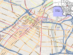
Downtown Los Angeles (DTLA) is the central business district of Los Angeles. It is part of the Central Los Angeles region and covers a 5.84 sq mi (15.1 km2) area. As of 2020, it contains over 500,000 jobs and has a population of roughly 85,000 residents, with an estimated daytime population of over 200,000 people prior to the COVID-19 pandemic. Despite a business exodus from downtown Los Angeles since the COVID-19 pandemic, the district is evolving as a cultural center with the world's largest showcase of architecture designed by Frank Gehry.

<span class="mw-page-title-main">Chinatown, Los Angeles</span> Neighborhood of Los Angeles

Chinatown is a neighborhood in Downtown Los Angeles, California, that became a commercial center for Chinese and other Asian businesses in Central Los Angeles in 1938. The area includes restaurants, shops, and art galleries, but also has a residential neighborhood with a low-income, aging population of about 7,800 residents.

<span class="mw-page-title-main">Century City</span> Neighborhood of Los Angeles in California, United States

Century City is a 176-acre neighborhood and business district in Los Angeles, California, United States. Located on the Westside to the south of Santa Monica Boulevard around 10 miles (16 km) west of Downtown Los Angeles, Century City is one of the most prominent employment centers in the Los Angeles metropolitan area, and its skyscrapers form a distinctive skyline on the city's westside.

<span class="mw-page-title-main">Historic Core, Los Angeles</span> Neighborhood of Downtown Los Angeles

The Historic Core is a district within Downtown Los Angeles that includes the world's largest concentration of movie palaces, former large department stores, and office towers, all built chiefly between 1907 and 1931. Within it lie the Broadway Theater District and the Spring Street historic financial district, and in its west it overlaps with the Jewelry District and in its east with Skid Row.

<span class="mw-page-title-main">Civic Center, Los Angeles</span> Neighborhood in Los Angeles, California, United States

The Civic Center neighborhood of Los Angeles, California, is the administrative core of the City of Los Angeles, County of Los Angeles, and a complex of city, county, state, and federal government offices, buildings, and courthouses. It is located on the site of the former business district of the city during the 1880s and 1890s, since mostly-demolished.

<span class="mw-page-title-main">Wilshire Boulevard</span> Major thoroughfare in the metropolitan Los Angeles area, United States

Wilshire Boulevard (['wɪɫ.ʃɚ]) is a prominent 15.83 mi (25.48 km) boulevard in the Los Angeles area of Southern California, extending from Ocean Avenue in the city of Santa Monica east to Grand Avenue in the Financial District of downtown Los Angeles. One of the principal east–west arterial roads of Los Angeles, it is also one of the major city streets through the city of Beverly Hills. Wilshire Boulevard runs roughly parallel to Santa Monica Boulevard from Santa Monica to the west boundary of Beverly Hills. From the east boundary, it runs a block south of Sixth Street to its terminus.

Central Los Angeles is the historical urban region of the City of Los Angeles, California.

The Grand Avenue Project was a government lead revitalization effort for the Bunker Hill neighborhood of Downtown Los Angeles on Grand Avenue and centered around Grand Park, its surrounding county government buildings and its parking lots. It was administered by the Grand Avenue Authority, a joint powers authority consisting of Los Angeles County and City. The first task was to improve the streetscape of Grand Avenue. The second element was to upgrade the 12-acre (4.9 ha) Grand Park in 2012 with a refurbished fountains, lawn furniture, walkways and the planting of native gardens. And lastly, constructing several residential buildings, including a two-tower complex on the southeast corner of Grand Avenue and 1st Street, designed by Frank Gehry.

<span class="mw-page-title-main">Prudent Beaudry</span> American politician (1819–1893)

Prudent Beaudry was a Canadian-born American politician who served as the 13th mayor of Los Angeles, from 1874 to 1876. A native of Quebec, he was the 2nd French Canadian and 3rd French-American mayor of Los Angeles.

<span class="mw-page-title-main">Cypress Park, Los Angeles</span> Neighborhood of Los Angeles

Cypress Park is a densely populated neighborhood of 10,000+ residents in Northeast Los Angeles, California. Surrounded by hills on three sides, it sits in the valley created by the Los Angeles River and the Arroyo Seco. It is the site of the Rio de Los Angeles State Park, the Los Angeles River Bike Path and other recreational facilities. It hosts one private and four public schools.

<span class="mw-page-title-main">Skid Row, Los Angeles</span> Neighborhood in Downtown Los Angeles

Skid Row is a neighborhood in Downtown Los Angeles. The area is officially known as Central City East.

<span class="mw-page-title-main">2Cal</span> 750-foot skyscraper in the Bunker Hill District of downtown Los Angeles

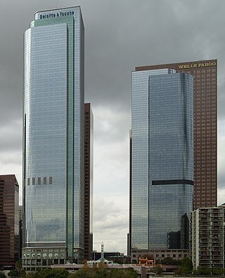
2Cal, formerly known as Two California Plaza, is a 750-foot (230 m) skyscraper in the Bunker Hill District of downtown Los Angeles, California, United States. The tower is part of the California Plaza project, consisting of two unique skyscrapers, One California Plaza and Two California Plaza. The Plaza is also home to the Los Angeles Museum of Contemporary Art (MoCA), Colburn School of Performing Arts, the Los Angeles Omni Hotel, and a 1.5-acre (0.61 ha) water court.

<span class="mw-page-title-main">The Salt Box</span> Historic site

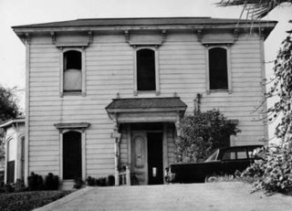
The Salt Box was a house built in the early 1880s in the Bunker Hill section of Los Angeles, California. Designed in the saltbox style that was popularized in New England, it was originally located at 339 South Bunker Hill Avenue. It was the home of physician Dr. A.G. Cook for most of the 1880s. In the late 19th century, Bunker Hill was one of the most prestigious neighborhoods in Los Angeles and was the site of many elegant Victorian homes. The Los Angeles Times wrote of old Bunker Hill: "Nowhere else in Los Angeles was the architecture so ornate. The mansions were wooden-frame Victorian with Gothic gingerbread touches applied with a heavy hand to simulate masonry." Though not as elegant as many of its Victorian neighbors, the Salt Box was "cherished by architecture students for the simplicity of its design."

<span class="mw-page-title-main">Hotel Alexandria</span> Historic building in Los Angeles, California

The Hotel Alexandria is a historic building constructed as a luxury hotel at the beginning of the 20th century in what was then the heart of downtown Los Angeles. As the business center of the city moved gradually westward, the hotel decayed and gradually devolved into a single-room occupancy (SRO) hotel housing long-term, low income residents and gained a reputation for crime and being unsafe. Revitalization of the area in the 21st century changed the rental practices and neighborhood safety.

Grand Avenue is a major north–south thoroughfare in Los Angeles, California. Primarily located in downtown's Bunker Hill, Financial, and South Park districts, the avenue features many of the area's most notable destinations, and also connects to City Hall via Grand Park.

<span class="mw-page-title-main">Central City West, Los Angeles</span> Neighborhood of Los Angeles in California, United States

Central City West, sometimes known as City West or The West Bank, is a neighborhood in Downtown Los Angeles.

Angels Landing is a proposed development complex in Downtown Los Angeles, California, consisting of two traditional high-rise buildings.

Victor Heights, sometimes referred to as the Forgotten Edge, is a neighborhood in Central Los Angeles.

References

  1. 2012-2013 Official Visitors Map, Los Angeles Tourism & Convention Board, 2012
  2. Vincent, Roger (May 30, 2018). "Condos, restaurants, an elementary school. How an 80-story skyscraper could transform Bunker Hill". Los Angeles Times . Retrieved May 31, 2018.
  3. Loukaitou-Sideris, A.; Sansbury, Gail (December 1, 1995). "Lost Streets of Bunker Hill". California History . 74 (4): 395. doi:10.2307/25177534. JSTOR   25177534.
  4. Creason, Glen (March 4, 2015). "CityDig: This 1869 Map Is an Antique Blueprint of Bunker Hill Los Angeles Magazine". Los Angeles Magazine.
  5. "Timeline: How Bunker Hill transformed Los Angeles and Grand Avenue". Los Angeles Times. May 22, 2019.
  6. Miranda, Carolina A. (May 22, 2019). "Bunker Hill once was a neighborhood. Then progress came to town". Los Angeles Times . Retrieved May 22, 2019.
  7. Pugsley, William (1977). Bunker Hill : last of the lofty mansions (1st ed.). Trans-Anglo Books. pp. 8–14. ISBN   0-87046-046-3.
  8. Pugsley, William (1977). Bunker Hill : last of the lofty mansions (1st ed.). Trans-Anglo Books. pp. 18–19. ISBN   0-87046-046-3.
  9. Mike Davis, "Hollywood's Dark Shadow," in Dead Cities and Other Tales (New York: The New Press, 2003; orig. ed. 2002), 132.
  10. Documentary "Bunker Hill" special feature on the DVD The Exiles
  11. Loukaitou-Sideris, A.; Sansbury, G. (December 1, 1995). "Lost Streets of Bunker Hill". California History . 74 (4): 396. doi:10.2307/25177534. JSTOR   25177534.
  12. Rosenberg, Jeremy (January 23, 2012). "Laws That Shaped L.A.: How Bunker Hill Lost its Victorians". KCET. Public Media Group of Southern California.
  13. Zerunyan, Frank. "The Demise of California Redevelopment Law, and the Repackaging of Tax Increments for California Municipalities | Bedrosian Center | USC". bedrosian.usc.edu. Sol Price School of Public Policy, University of Southern California.
  14. Jones, Stephen (September 1, 2017). "The Bunker Hill Story: Welfare, Redevelopment, and Housing Crisis in Postwar Los Angeles". All Dissertations, Theses, and Capstone Projects: 10.
  15. Amended Redevelopment Plan: Bunker Hill Urban Renewal Project (PDF) (Report). The Community Redevelopment Agency of the City of Los Angeles, California.
  16. Committee on Banking and Currency. "Housing act of 1949" (PDF). Archived from the original (PDF) on February 15, 2016.
  17. Stevenson, Richard W. (November 11, 1991), "Office Glut Spreads in California", New York Times
  18. Berton, Brad (April 26, 1993), "Los Angeles Community Redevelopment Agency's notice of default suit against Bunker Hill Associates", Los Angeles Business Journal[ permanent dead link ]
  19. Vincent, Roger (February 13 2014) "With sale of Two California Plaza, Bunker Hill is poised for comeback" Los Angeles Times
  20. "Building Healthy Communities 101". lacity.org. Archived from the original on February 16, 2005.
  21. Maese, Kathryn (March 28, 2005). "Cracking the Code: Planning Shift Could Be Most Important Housing Move Since Adaptive Reuse Ordinance". Los Angeles Downtown News . Retrieved July 11, 2022.
  22. Vincent, Roger (October 1, 2014) "Developer of new Bunker Hill apartment high-rise woos older residents" Los Angeles Times
  23. Wilson, William (July 7, 1992). "ART REVIEW : A Goddess for L.A.? : New Graham Sculpture a Welcoming Figure". Los Angeles Times. Retrieved September 13, 2020.
  24. Gordon, Larry (February 25, 1996). "Maiden Voyage: Historic Angels Flight Railway Reopens to Public With Plenty of Revelry and a Wisp of Nostalgia". Los Angeles Times.
  25. Vankin, Deborah (September 21, 2015). "The heat and the lines couldn't keep them from the Broad on opening day". Los Angeles Times. Retrieved June 19, 2017.
  26. LA Downtown News Will Angels Flight Ever Roll Again?
  27. tumblr. Los Angeles's Bunker Hill: Pulp Fiction's Mean Streets and Film Noir's Ground Zero!
  28. Electric Earl Bunker Hill Goes to the Movies
  29. Dimendberg, Edward. "From Berlin to Bunker Hill: Urban Space, Late Modernity, and Film Noir in Fritz Lang's and Joseph Losey's M". Pitzer College. Archived from the original on September 2, 2006.
  30. Time Friday, July 18, 2008 Exiles on Indie Street By Richard Corliss
  31. LA Observed July 31, 2010 Weekend viewing: Bunker Hill, 1956 by Kevin Roderick
  32. LA Observed August 3, 2010 Bunker Hill video deleted from Vimeo * By Kevin Roderick
  33. Los Angeles Film Forum This is the City
  34. Oscilloscope The Exiles
  35. Flood, Alison (November 14, 2018). "Robin Robertson wins Goldsmiths prize for innovative fiction with The Long Take". The Guardian . Retrieved March 14, 2019.
  36. "Film and poetry, and a bit of Bob Dylan". The Film Programme . March 14, 2019. 00:50 minutes in. BBC. BBC Radio 4 . Retrieved March 14, 2019.
  37. Kellogg, Carolyn (April 9, 2010). "For John Fante, it's hip to get a square in downtown Los Angeles". Los Angeles Times. Retrieved August 24, 2022.
  38. "Central Community Police Station - Los Angeles Police Department". www.lapdonline.org. Retrieved January 13, 2021.
  39. "Station 3 | Los Angeles Fire Department". www.lafd.org. Retrieved January 13, 2021.