The Point Pleasant Micropolitan Statistical Area, as defined by the United States Census Bureau, is an area consisting of two counties – one in West Virginia and one in Ohio – anchored by the city of Point Pleasant, West Virginia.

The Clarksburg Micropolitan Statistical Area, as defined by the United States Census Bureau, is an area consisting of four counties in North-Central West Virginia, anchored by the city of Clarksburg.

The Watertown Micropolitan Statistical Area, as defined by the United States Census Bureau, is an area consisting of two counties in South Dakota, anchored by the city of Watertown. As of the 2000 census, the μSA had a population of 31,437.

The Hastings Micropolitan Statistical Area, as defined by the United States Census Bureau, is an area consisting of two counties in Nebraska, anchored by the city of Hastings.

The Norfolk Micropolitan Statistical Area, as defined by the United States Census Bureau, is an area consisting of three counties in Nebraska, anchored by the city of Norfolk.

The Kearney Micropolitan Statistical Area, as defined by the United States Census Bureau, is an area consisting of two counties in Nebraska, anchored by the city of Kearney.

The Burley Micropolitan Statistical Area, as defined by the United States Census Bureau, is an area consisting of two counties in the Magic Valley region of Idaho, anchored by the city of Burley. It is commonly referred to locally as the "Mini-Cassia" area, an amalgam of Minidoka and Cassia Counties.

The New Bern Metropolitan Statistical Area, as defined by the United States Census Bureau, is an area consisting of three counties in the Inner Banks region of eastern North Carolina, anchored by the city of New Bern. The designation of the area was changed from Micropolitan to Metropolitan in 2013.

The Roanoke Rapids, NC Micropolitan Statistical Area (μSA) as defined by the United States Census Bureau, is an area consisting of two counties in North Carolina, anchored by the city of Roanoke Rapids.

The Ardmore Micropolitan Statistical Area, as defined by the United States Census Bureau, is an area consisting of two counties in South Central Oklahoma, anchored by the city of Ardmore.
The Galesburg, IL Micropolitan Statistical Area, as defined by the United States Census Bureau, is an area consisting of two counties in west central Illinois, anchored by the city of Galesburg.

The Burlington, IA−IL Micropolitan Statistical Area, as defined by the United States Census Bureau, is an area consisting of two counties−one in southeast Iowa and the other in West Central Illinois, anchored by the city of Burlington, Iowa.

The Jacksonville, IL Micropolitan Statistical Area, as defined by the United States Census Bureau, is an area consisting of two counties in west central Illinois, anchored by the city of Jacksonville.
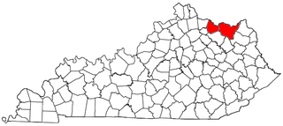
The Maysville Micropolitan Statistical Area (μSA), as defined by the United States Census Bureau, is coterminous with Mason County, Kentucky, whose county seat and largest city is Maysville. As of the 2010 census, the population of Mason County and the current µSA was 17,490, and 2014 Census Bureau estimates place the population at 17,166.
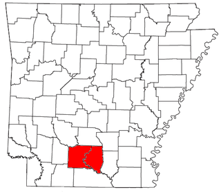
The Camden Micropolitan Statistical Area, as defined by the United States Census Bureau, is an area consisting of two counties in the U.S. state of Arkansas, anchored by the city of Camden.

The Alexander City Micropolitan Statistical Area is a former micropolitan statistical area that consisted of two counties in Alabama, anchored by the city of Alexander City, as defined by the United States Census Bureau. As of the 2010 census, the μSA had a population of 53,155.

The Waycross Micropolitan Statistical Area (μSA), as defined by the United States Census Bureau, is an area consisting of two counties in Georgia, anchored by the city of Waycross.
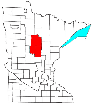
The Brainerd Micropolitan Statistical Area, as defined by the United States Census Bureau, is an area consisting of Cass County and Crow Wing County in Northern Minnesota, anchored by the city of Brainerd. As of July 1, 2022 estimate placed the population at 99,222.

The Dickinson Micropolitan Statistical Area, as defined by the United States Census Bureau, is an area consisting of two counties in North Dakota, anchored by the city of Dickinson. As of the 2010 census, the μSA had a population of 24,982.

The Martinsville Micropolitan Statistical Area is a United States Micropolitan Statistical Area (USA) in Virginia, as defined by the Office of Management and Budget (OMB) as of June, 2003. As of the 2000 census, the μSA had a population of 73,346.

