
New Bedford is a city in Bristol County, Massachusetts, United States. It is located on the Acushnet River in what is known as the South Coast region. Up through the 17th century, the area was the territory of the Wampanoag Native American people. English colonists bought the land on which New Bedford would later be built from the Wampanoag in 1652, and the original colonial settlement that would later become the city was founded by English Quakers in the late 17th century. The town of New Bedford itself was officially incorporated in 1787.

Butler Flats Light is a sparkplug lighthouse located in the outer harbor of New Bedford, Massachusetts, at the mouth of the Acushnet River. Built in 1898 by the United States Lighthouse Board, it is the only known caisson lighthouse designed by a marine architect. The light was added to the National Register of Historic Places as Butler Flats Light Station on June 15, 1987. Automated in 1978, it is now operated by the city as a private aid to navigation.

This is a list of properties and districts in Massachusetts listed on the National Register of Historic Places. There are over 4,300 listings in the state, representing about 5% of all NRHP listings nationwide and the second-most of any U.S. state, behind only New York. Listings appear in all 14 Massachusetts counties.

The New Bedford Historic District is a National Historic Landmark District in New Bedford, Massachusetts, United States, west of the community's waterfront. During the 19th century, when the city was the center of the American whaling industry, this was its downtown. After its decline in the early and mid-20th century, through the efforts of local activist groups the district has since been preserved and restored to appear much as it was during that period.
The Parkhill Mill is an historic mill complex at 1 Oak Hill Road in Fitchburg, Massachusetts. Built between 1885 and 1915, it was one of three mill complexes of the Parkill Company, one of the city's largest employers of the period. The mill complex was added to the National Register of Historic Places in 2008. The complex has been restored and is used by a variety of public and private businesses, and as residential space.

The South Britain Historic District encompasses the core of the unincorporated village of South Britain in Southbury, Connecticut, United States. The village arose in the 18th century as an industrial center serving the surrounding agricultural community, powered by the Pomperaug River, and rivalled the town center of Southbury in importance. The district was listed on the National Register of Historic Places in 1987.

The South Glastonbury Historic District is a historic district in Glastonbury, Connecticut. It encompasses the historic village center of South Glastonbury, which was first settled in the 17th century. The district was listed on the National Register of Historic Places in 1984, and enlarged in 2009 to include properties further along Main Street as far as Chestnut Hill Road. Locals refer to it as Nayaug.

The Lower Highlands Historic District encompasses one of the oldest residential areas of Fall River, Massachusetts. The district is roughly bounded by Cherry, Main, Winter, and Bank Streets, and is located just east of the Downtown Fall River Historic District and directly south of the Highlands Historic District. This area was settled by 1810, has architecture tracing the city's growth as a major industrial center. The historic district was added to the National Register of Historic Places in 1984.

The Acushnet Heights Historic District is a predominantly residential historic district in central New Bedford, Massachusetts. It encompasses a densely-built urban area about 20 acres (8.1 ha) in size, which was developed as a working-class area, beginning in the 1860s, for the many workers in the city's factories. The district was listed on the National Register of Historic Places in 1989. It abuts the North Bedford Historic District, which is just to the south, and includes the following separately-listed properties: the Union Street Railway Carbarn, the Bradford Smith Building, and the Dawson Building.

The Whitman Mills are a historic mill complex on the banks of the Acushnet River north of central New Bedford, Massachusetts. The mill yard is bounded by Riverside Street, Manomnet Street, Coffin Street, and the river. It is just one of a group of mill complexes developed by William Whitman in the area around the turn of the 20th century. This particular grouping, including two large mills, an office, and several outbuildings, was built between 1896 and 1917, with most of those original buildings still standing. The mills operated until 1932, when the Whitman Company went bankrupt. The complex was nearly demolished in the 1950s, but has since been subdivided and occupied by a succession of smaller businesses.

The Bradford Smith Building was a historic building at 1927–1941 Purchase Street in New Bedford, Massachusetts. It was a 3+1⁄2-story wood-frame structure, with a double-gabled roof and a stone-and-brick foundation. It was built in 1887 by Bradford Smith, a retired employee of the Taunton-New Bedford Copper Company, and housed retail space on the first floor and apartments above.

Fairhaven High School and Academy is a public high school in Fairhaven, Massachusetts, United States. Its main building, built in 1905, is known as the "Castle on the Hill" and it is part of the Fairhaven Public Schools district. The school was voted the "most beautiful high school in Massachusetts" in 2017.
The Baldwinville Village Historic District encompasses the historic elements of the village of Baldwinville, a 19th-century mill village in northern Templeton, Massachusetts. Although its industrial elements have largely been lost, the district retains period housing and civic buildings. It was listed on the National Register of Historic Places in 1986.

The North Canal Historic District of Lawrence, Massachusetts, encompasses the historic industrial heart of the city. It is centered on the North Canal and the Great Stone Dam, which provided the waterpower for its many mill complexes. The canal was listed on the National Register of Historic Places in 1975, while the district was first listed in 1984, and then expanded slightly in 2009.

The Bedford Center Historic District encompasses the historic heart of the town of Bedford, Massachusetts. It extends along Great Road between Bacon and Concord Roads, and includes primarily residential areas on adjacent side streets. The area includes the town's main civic buildings, its first cemetery, and a diverse array of residential architecture spanning more than two centuries. The district was listed on the National Register of Historic Places in 1977; its boundaries were adjusted in 2014 and its period of significance extended.

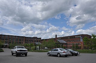
The Manomet Mills are a historic textile mill complex on the north side of New Bedford, Massachusetts. They are located between Riverside Avenue and the Acushnet River, north of Manoment Street and the Whitman Mills. The complex consists of three Classical Revival brick buildings, built between 1903 and 1907. The main building, Mill No. 1, is a 54-bay three story structure that was built in 1903. It is attached to Mill No. 2 (1907), of similar size, by a single story brick structure. The third building is the Mill No. 2 Department Room (1907), a two-story brick building that was originally connected to the other two via overhead bridges, now removed. The mill complex was the main operating site of the Manoment Mill Company, which produced cotton yarn until about 1928. The buildings were sold in that year to the Delaware Rayon Company, which went bankrupt in 1954. Mill No. 2 was then used by the Acushnet Process Company for the manufacture of golf balls, while Mill No. 1 continued to be used for rayon production, a chemically intensive and environmentally hazardous process.

The Brattleboro Downtown Historic District encompasses most of the central business district of the town of Brattleboro, Vermont. Extending along Main Street between Whetstone Brook and a junction with Pultney Road and Linden and Walnut Streets, this area includes many of the town's prominent civic and institutional buildings. The area's development took place primarily in the 19th century, with surviving buildings from both the 18th and early 20th centuries. The district was listed on the National Register of Historic Places in 1983, and was enlarged in 2004 to include Plaza Park and the Holstein Building on the south side of Whetstone Brook.

The Waitsfield Village Historic District encompasses much of the main village center of Waitsfield, Vermont. Extending along Vermont Route 100 on either side of Bridge Street, it is a well-preserved example of a 19th-century village, with only a few sympathetic 20th-century additions. It was listed on the National Register of Historic Places in 1983.
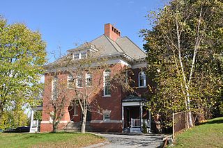
The Oxford School is a historic school building at 347 Main Street in Fairhaven, Massachusetts. Built in 1896 and enlarged in 1921, it was the town's first large elementary school, built for an part of the community which grew rapidly due to its proximity to the mills of New Bedford. The building, a good example of period neo-Classical architecture, was listed on the National Register of Historic Places in 2023. It has been converted to residential use.


