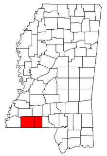
The McComb Micropolitan Statistical Area is a micropolitan area in southwestern Mississippi that includes the counties of Amite and Pike. As of the 2000 census, this μSA had a population of 210,875.

The Pierre Micropolitan Statistical Area, as defined by the United States Census Bureau, is an area consisting of two counties in South Dakota, anchored by the state capital city, Pierre. As of the 2000 census, the μSA had a population of 19,253.

The Scottsbluff Micropolitan Statistical Area, as defined by the United States Census Bureau, is an area consisting of two counties in Nebraska, anchored by the city of Scottsbluff.
The Ontario Micropolitan Statistical Area, as defined by the United States Census Bureau, is an area consisting of two counties – one in southeastern Oregon and one in southwestern Idaho, anchored by the city of Ontario.
The Galesburg, IL Micropolitan Statistical Area, as defined by the United States Census Bureau, is an area consisting of two counties in west central Illinois, anchored by the city of Galesburg.
The Paducah, KY-IL Micropolitan Statistical Area, as defined by the United States Census Bureau, is an area consisting of four counties – two in the Jackson Purchase region of Kentucky, a third Kentucky county bordering the Purchase, and one in southern Illinois – anchored by the city of Paducah, Kentucky.

The Frankfort Micropolitan Statistical Area, as defined by the United States Census Bureau, is an area consisting of two counties in central Kentucky, anchored by the city of Frankfort. As of the 2000 census, the Micropolitan Statistical Area (μSA) had a population of 66,798.
The Richmond–Berea Micropolitan Statistical Area, as defined by the United States Census Bureau, is an area consisting of two counties in Kentucky, anchored by the cities of Richmond and Berea. As of the 2000 census, the μSA had a population of 87,454.
The Mount Sterling Micropolitan Statistical Area, as defined by the United States Census Bureau, is an area consisting of three counties in Kentucky, anchored by the city of Mount Sterling. As of the 2000 census, the μSA had a population of 40,195.

The Glasgow Micropolitan Statistical Area, as defined by the United States Census Bureau, is an area consisting of two counties in Kentucky, anchored by the city of Glasgow. As of the 2000 census, the μSA had a population of 48,070.

The Danville Micropolitan Statistical Area, as defined by the United States Census Bureau, is an area consisting of Boyle and Lincoln counties in Kentucky, anchored by the city of Danville. As of the 2000 census, the μSA had a population of 51,058. A July 1, 2009 estimate placed the population at 54,435.

The Hannibal Micropolitan Statistical Area, as defined by the United States Census Bureau, is an area consisting of two counties in northeast Missouri, anchored by the city of Hannibal.

The Russellville Micropolitan Statistical Area, as defined by the United States Census Bureau, is an area consisting of two counties in the U.S. state of Arkansas, anchored by the city of Russellville.

The Martinsville Micropolitan Statistical Area is a United States Micropolitan Statistical Area (μSA) in Virginia, as defined by the Office of Management and Budget (OMB) as of June, 2003. As of the 2000 census, the μSA had a population of 73,346.

The Jasper micropolitan statistical area, as defined by the United States Census Bureau, is an area consisting of two counties in southwestern Indiana, anchored by the city of Jasper. At the 2010 census, the Micropolitan area (μSA) had a population of 54,734 up from a population of 52,511 in the 2000 census. The micropolitan area covers an area of 776 sq mi (2,010 km2).

The Dublin Micropolitan Statistical Area, as defined by the United States Census Bureau, is an area consisting of two counties in Georgia, anchored by the city of Dublin.

The Vidalia Micropolitan Statistical Area, as defined by the United States Census Bureau, is an area consisting of two counties in Georgia, anchored by the city of Vidalia, the largest city in Toombs County.

The Milledgeville Micropolitan Statistical Area, as defined by the United States Census Bureau, is an area consisting of two counties in Georgia, anchored by the city of Milledgeville.

The Corbin Micropolitan Statistical Area, as defined by the United States Census Bureau, is an area consisting of Whitley County, Kentucky, anchored by the Whitley County portion of the city of Corbin. As of the 2000 census, the μSA had a population of 35,865.

The London, Kentucky micropolitan area is made up of three counties in the Eastern Coalfield region of Kentucky. Before 2013, the area was officially known as the Corbin-London, KY Combined Statistical Area, and consisted of the Corbin Micropolitan Statistical Area and the London Micropolitan Statistical Area. The Corbin micropolitan area consisted of Whitley County, and the London micropolitan area consisted of Laurel County.


