
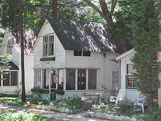
Washington Grove is a town in Montgomery County, Maryland, United States. The population was 505 at the 2020 census. The Washington Grove Historic District was listed on the National Register of Historic Places in 1980.

Oak Bluffs is a town located on the island of Martha's Vineyard in Dukes County, Massachusetts, United States. The population was 5,341 at the 2020 United States Census. It is one of the island's principal points of arrival for summer tourists, and is noted for its "gingerbread cottages" and other well-preserved mid- to late-nineteenth-century buildings. The town has been a historically important center of African American culture since the eighteenth century.

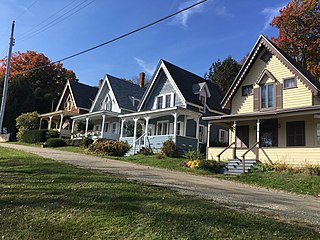
Wesleyan Grove is a 34-acre (14 ha) National Historic Landmark District in Oak Bluffs, Massachusetts on the island of Martha's Vineyard. Named after John Wesley, the founder of the Methodist Church. Also known as the Martha's Vineyard Campmeeting Association (MVCMA) or the Campgrounds, it was the first summer religious camp established in the United States. It is famous for its approximately 300 colourful cottages in a style now described as Carpenter Gothic.

The Dr. Harrison A. Tucker Cottage is a historic summer cottage at 61 Ocean Avenue in Oak Bluffs, Massachusetts. The cottage took shape in the 1870s as a combination of several smaller structures that were joined by an addition. Doctor Tucker was a resident of Cottage City, as Oak Bluffs was then known, and invited Ulysses S. Grant during his time there. Tucker was also a leading figure in the Oak Bluffs Land and Wharf Company, which spearheaded development of the town outside the Methodist meeting camp known as Wesleyan Grove. The house was listed on the National Register of Historic Places in 1990, for its association with Dr. Tucker, and as one of the most elaborate Victorian houses in the town.

The Wianno Historic District is a historic district in the Osterville section of Barnstable, Massachusetts. It encompasses a well-preserved summer resort area for the wealthy that was first developed in the late 19th century, focused around the Wianno Club, built in 1881 on the site of an earlier resort hotel. The 40-acre (16 ha) district has a significant number of well-preserved Shingle style and Colonial Revival houses. Architect Horace Frazer designed the Wianno Club, as well as a number of the private residences in the district. The district is roughly bounded by East Bay Road, Wianno and Sea View Avenues between Nantucket Sound and Crystal Lake. It was added to the National Register of Historic Places in 1987.

The Wianno Club is a historic club at 107 Sea View Avenue in Osterville, Massachusetts. The club began as the Cotocheset House, a Shingle-style structure built in 1882 on the site of a grander hotel that burned down in 1881. This hotel was the centerpiece of a major resort development for the wealthy that was mostly developed prior to World War I. In 1916 the newly founded club purchased the hotel property. The club built a nine-hole golf course on the original land purchase now occupied by holes numbered 13-18. The 16th was the first hole, and the Swan residence behind the hole was built as the original clubhouse. Additional land was assembled on the west side of Parker Road and north of West Bay Road and in 1919, Donald Ross was hired to redesign the original nine and to create a new nine.

The Craigville Historic District encompasses a historic religious camp meeting area in the Craigville section of Barnstable, Massachusetts, United States. It is centered on the junction of Lake Elizabeth Drive and Ocean Avenue, just west of Lake Elizabeth. The camp meeting was established in 1871 by the New England Convention of Christian Churches on land that was purchased from members of the Perry family. Along the grid of roads south of the main junction, gingerbread-decorated Gothic cottages were built over the following decades. The main tabernacle, an open-walled church, was built in 1887. The district was listed on the National Register of Historic Places in 1987.

The Marstons Mills Community Church, formerly the Methodist Church, is a historic church building in the Marstons Mills village of Barnstable, Massachusetts. The white clapboard church was built in the town of Yarmouth, and moved to Marstons Mills in 1830. Its small belfry tower was added sometime between 1888 and 1908, around the same time it acquired some of its Queen Anne stylistic elements. The church was listed on the National Register of Historic Places in 1987 for its architecture and for its role in community history.

The Mill Way Historic District encompasses a residential area significant in the development of the maritime industry in Barnstable Village, Massachusetts. It includes thirteen houses, ten on Mill Way and three on adjacent Freezer Road, just north of the Old King's Highway. The district was listed on the National Register of Historic Places in 1987.

The Northside Historic District encompasses two of the earliest significant settlement areas of Yarmouth, Massachusetts. Stretching along Massachusetts Route 6A from the Barnstable line in the west to White Brook in the east, the district includes almost 300 buildings on 50 acres (20 ha). It includes the two villages of Yarmouth Center and Yarmouthport, which were important 18th and 19th century centers of civic and economic activity.

The South Yarmouth/Bass River Historic District is a historic district in the southeastern part of Yarmouth, Massachusetts. It encompasses a predominantly residential area centered on a portion of Old Main Street and South Street between the villages of South Yarmouth and Bass River. The area's history is one of maritime-related industry from the late 18th to late 19th century, and then its growth as a tourist resort community. The district was listed on the National Register of Historic Places in 1990.

Asbury Grove, located in Hamilton, Massachusetts, was formed during the camp meeting religious movement popular in the mid-19th century. Originally set on seventy-five acres of land, the camp was founded by the Methodist church in 1857. Ten of the original seventy-five acres were purchased from Joseph Dodge, a local farmer. This land included a farmhouse, which later became the Superintendent's Cottage.

Pitman Grove is a 20-acre (8.1 ha) historic district located in the borough of Pitman in Gloucester County, New Jersey. It was added to the National Register of Historic Places on August 19, 1977, for its significance in architecture, religion, and community planning. The district includes 349 contributing buildings.

The Massanetta Springs Historic District is a retreat in Rockingham County, Virginia, administered by the Presbyterian Synod of the Mid-Atlantic, and chiefly associated with the Massanetta Springs Summer Bible Conference Encampment. The district includes the Hotel (1910), Hudson Auditorium (1922) and Camp Massanetta (1955–56). A Methodist camp existed at the site, originally known as Taylor's Springs, from 1816.

Since 1895, Fountain Park has hosted an annual Chatauqua to promote traditional values and religious, social and educational activities. It was added to the National Register of Historic Places on December 7, 2001.
Des Plaines Methodist Camp Ground is a historic Methodist church camp at 1250 Campground Road in Des Plaines, Illinois, USA.

The Chester Heights Camp Meeting Historic District is a historic Methodist camp meeting and national historic district located in Chester Heights, Delaware County, Pennsylvania. The district includes 101 contributing buildings, which were designed in the vernacular camp meeting style of architecture; additional notable examples of the Gothic Revival and Queen Anne styles also are present here. Public buildings include the contributing Tabernacle (1878), Dining Hall (1900), Youth Tabernacle (1909, and dormitory. Most of the contributing buildings are cottages, which were built roughly between 1876 and 1920.
Chapel Hill Church Tabernacle is a historic Methodist church tabernacle located near Denton, Davidson County, North Carolina. It was built in 1870 and enlarged in the 1920s. It is a one-story, heavy-timber, open-framework building, open on three sides. It has a concrete floor and a gable-on-hip roof. The tabernacle was originally used for the religious services at the annual camp meetings. The tabernacle is located on the grounds of Chapel Hill United Methodist Church, whose congregation dates from 1854.

The Pleasant Grove Camp Meeting Ground is a historic Methodist camp meeting national historic district located near Waxhaw, Union County, North Carolina. The district encompasses four contributing buildings and one contributing site. The main building is the arbor that dates to 1830. It is an 80 feet long by 60 feet wide open sided frame structure with a gable roof surround on all four sides by pent roof extensions. Located nearby are the church and former schoolhouse, now used as the preacher's dwelling, and the old cemetery.
The Bayside Historic District encompasses the historic core of a former religious summer camp meeting community in Northport, Maine, USA. It includes the original grounds of the Northport Wesleyan Grove Camp Meeting, established in 1848, with most of surviving architecture built between about 1870 and 1920. It is the largest surviving such area in the state, and was listed on the National Register of Historic Places in 1996. It is now the heart of the Bayside village, a secular seaside summer resort community.


