Related Research Articles
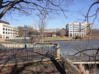
Columbia is a census-designated place in Howard County, Maryland, United States. It is a planned community consisting of 10 self-contained villages. The census-designated place had a population of 104,681 at the 2020 census, making it the second most populous community in Maryland after Baltimore. Columbia, located between Baltimore and Washington, D.C., is officially part of the Baltimore metropolitan area.

Clarksville is an unincorporated community in Howard County, Maryland; the second highest-earning county in the United States according to the U.S. Census Bureau. The community is named for William Clark, a farmer who owned much of the land on which the community now lies and served as a postal stop that opened on the 4th of July 1851.

Guilford is an unincorporated community located in Howard County in the state of Maryland. The location is named after the Guilford Mill. Guilford is near Kings Contrivance, one of the nine "villages" of Columbia.

River Hill is the last and westernmost village to be developed in the town of Columbia, Maryland, United States, though some residents maintain addresses in Clarksville. The village is home to 6,520 residents in 2,096 housing units in 2014. The area was used as a game preserve by James Rouse to entertain clients and personal hunting during the buildout of the Columbia project. In 1976, County Executive Edward L. Cochran selected the 784-acre parcel owned by Howard Research and Development for an alternate location for a county landfill; a task force selected Alpha Ridge Landfill instead. Residential construction started in 1990. It is bounded by Maryland Route 108 and Maryland Route 32, and is centered on Trotter Road. The village is divided into two neighborhoods: Pheasant Ridge and Pointers Run, with about 6,500 residents.
Kings Contrivance is a village in the planned community of Columbia, Maryland, United States and is home to approximately 11,000 residents. It is Columbia's southernmost village, and was the eighth of Columbia's ten villages to be developed. Kings Contrivance consists of the neighborhoods of Macgill's Common, Huntington and Dickinson, and includes single-family homes, townhouses, apartments and a Village Center.
Oakland Mills is one of the 10 villages in Columbia, Maryland, United States. It is located immediately east of Town Center, across U.S. Route 29.
Hickory Ridge is one of the 10 villages in Columbia, Maryland, United States, located to the west of the Town Center with a 2014 population of 13,000 in 4,659 housing units. The village overlays the former postal community of Elioak. It was first occupied in 1974. Neighborhoods in the village are Hawthorn, Clary's Forest, and Clemens Crossing. The name Hickory Ridge is derived from the 1749 estate "Hickory Ridge" in nearby Highland, which later became the family home of the nephew of hospital and university founder Johns Hopkins.
Long Reach, one of ten villages composing Columbia, Maryland, United States, is found in the northeast part of Columbia along Maryland Route 108. Started in 1971, it is one of the oldest villages, and comprises four neighborhoods: Jeffers Hill, Kendall Ridge, Locust Park, and Phelps Luck. The village, with an approximate population of 15,600, is governed by five elected village board members through "Long Reach Community Association, Inc." The Village Office is located in Stonehouse, the community center, which opened in 1974.
The Howard County Public School System (HCPSS) is the school district that manages and runs the public schools of Howard County, Maryland. It operates under the supervision of an elected, eight-member Board of Education. Antonia Watts is the chair of the board. Michael J. Martirano has served as the superintendent since May 2017.
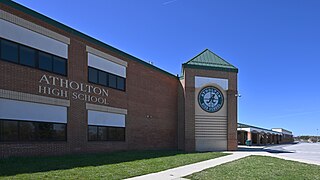
Atholton High School is a high school in Columbia, Maryland, United States and is a part of the Howard County public school system. The school hosts an Army JROTC program. The school mascot is the Raider.
Highland is an unincorporated community and census-designated place in Howard County, Maryland, United States. As of the 2020 census it had a population of 1,133. It uses the 20777 zip code.
Dayton is an unincorporated community located in Howard County, Maryland, United States.
Simpsonville is an unincorporated community in Howard County, Maryland, United States.
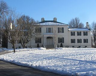
Oakland or Oakland Manor is a Federal style stone manor house commissioned in 1810 by Charles Sterrett Ridgely in the Howard District of Anne Arundel County Maryland. The lands that became Oakland Manor were patented by John Dorsey as "Dorsey's Adventure" in 1688 which was willed to his grandson Edward Dorsey. In 1785, Luther Martin purchased properties named "Dorsey's Adventure", "Dorsey's Inheritance", "Good for Little", "Chew's Vineyard", and "Adam the First" to make the 2300 acre "Luther Martin's Elkridge Farm".
Elioak is an unincorporated community in Howard County, Maryland, United States. It was the home of the "Pushpin Farm", a 200-acre slave plantation purchased in 1724 in the Howard District of Anne Arundel County by Col. Edward Dorsey and which is the site of many prominent Dorsey family graves. The postal community was named after the Elioak plantation built by Owen Dorsey, Judge of the Baltimore Orphans' Court. A postal office operated in the community from 12 June 1893 to 15 September 1922. Local farm orchards were known for prize winning apples and pears. Local families such as the Kahler, Miller, and Worthington claimed Elioak as home while they served in World War I. After the war, the name fell out of use.
Located in the Simpsonville area of Columbia in Howard County, Maryland, United States, Athol Plantation.

Athol is a historic slave manor and rectory located in Columbia (Simpsonville), Howard County, Maryland, U.S.

Guilford Road is a historic road north of Savage, Maryland that traverses Anne Arundel and Howard Counties in an area that was first settled by English colonists in the mid-1600s. Today's Guilford road is a series of disconnected segments bisected multiple times by the construction of Maryland Route 32.
Harriet Tubman School was a segregated public school in Columbia, Maryland, operating from 1949 to 1965. It was part of Howard County Public School System.
The Locust United Methodist Church is a historic African-American church in Columbia, Maryland.
References
- ↑ "Checklist of Maryland Post Offices" (PDF). Smithsonian National Postal Museum. Archived from the original (PDF) on August 15, 2013. Retrieved May 17, 2014.
- ↑ Collection Research: Land Owners & Patents, 1670-1812 ACCESSION NO. A.3.a. iii Property Owners, Land Names, & Acreage – covering Anne Arundel (Howard), Baltimore, Frederick, and Montgomery Counties.
- ↑ "Athol" (PDF). Retrieved March 5, 2013.
- ↑ "HO-37" (PDF). Retrieved July 14, 2013.
- ↑ Barbara W Feagan. Howard's Roads to the Past. p. 85.
- ↑ Alice Cornelison; Silas E. Craft Sr.; Lillie Price. History of Blacks In Howard County. p. 40.
- ↑ Howard's Roads to the Past. Howard County Sesquicentennial Celebration Committee, 2001. 2001. pp. 81–82.
- ↑ "Shopping Center - New of Howard's Scene". The Times. March 31, 1965.
- ↑ "Holiday Hills Blaze". The Times. March 31, 1965.
Municipalities and communities of Howard County, Maryland, United States | ||
|---|---|---|
| CDPs |  | |
| Villages | ||
| Unincorporated communities |
| |
| Ghost town | ||
| Footnotes | ‡This populated place also has portions in an adjacent county or counties | |
39°10′54″N76°52′28″W / 39.18167°N 76.87444°W