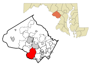
Potomac is a census-designated place (CDP) in Montgomery County, Maryland, United States, named after the nearby Potomac River. Potomac is the seventh most educated small town in America, based on percentage of residents with postsecondary degrees. Bloomberg Businessweek labeled Potomac as the twenty-ninth-richest zip code in the United States in 2011, stating that it had the largest population of any U.S. town with a median income of more than $240,000. In 2012, The Higley Elite 100 published a list of highest-income neighborhoods by mean household income, which included four neighborhoods in Potomac; one of these neighborhoods, "Carderock-The Palisades" was ranked the highest-income neighborhood in the United States, followed by "Beverly Hills-North of Sunset" in Beverly Hills, California and "Swinks Mill-Dominion Reserve" of McLean, Virginia. More recently, two Potomac neighborhoods were ranked among the ten wealthiest neighborhoods in the country by CNBC in 2014. In 2018, data from the American Community Survey revealed that Potomac was the sixth-wealthiest city in the United States. Many Potomac residents work in nearby Washington, D.C.

Clarksville is an unincorporated community in Howard County, Maryland; the second highest-earning county in the United States according to the U.S. Census Bureau. The community is named for William Clark, a farmer who owned much of the land on which the community now lies and served as a postal stop that opened on the 4th of July 1851.

Hanover is an unincorporated community in the Baltimore/Annapolis area in northwestern Anne Arundel County and eastern Howard County in the U.S. state of Maryland, located south of Baltimore.
The Howard County Public School System (HCPSS) is the school district that manages and runs the public schools of Howard County, Maryland. It operates under the supervision of an elected, eight-member Board of Education. Dr. Chao Wu is the Chairman of the Board. Michael J. Martirano has served as the Superintendent since May 2017.

West Friendship is a semi-rural unincorporated community in western Howard County, Maryland, United States. West Friendship is located at the junction of Interstate 70 and Maryland Route 32. Frederick Road is a main thoroughfare.
Glenelg is an unincorporated community in Howard County, Maryland, United States. It is located in the 21737 zip code, and is part of the 410 area code. It is the home town of Glenelg High School.
Highland is an unincorporated community and census-designated place in Howard County, Maryland, United States. As of the 2010 census it had a population of 1,034. It uses the 20777 zip code.

Harper's Choice is one of the ten villages that comprise Columbia, Maryland, United States. It lies in the northwest part of Columbia and consists of the neighborhoods of Longfellow, Swansfield, and Hobbit's Glen and had a December 1998 population of 8,695.
Loch Raven is a neighborhood extending from northeast Baltimore City to the eastern part of Baltimore County, Maryland. The major road in the neighborhood is Loch Raven Boulevard, which stretches all the way from the I-695 beltway in Baltimore County to 25th Street in Baltimore City. It is located in the Baltimore Metro Area, and is considered one of the longest roads in the area with many different aspects of Baltimore that can be seen by riding through the area. This region is a diverse, but predominantly African American part of the city and county, and is also the area that consists of a large amount of Morgan State University students. The zip codes assigned to this area are 21218, 21239, 21286, 21284, and 21234, which is also a Parkville zip code.
Fulton is a census-designated place located in southern Howard County, Maryland, United States. As of the 2010 census it had a population of 2,049.
Woodstock is an unincorporated community which is a suburb of Baltimore, Maryland, United States. The original village of Woodstock is located in Howard County, and also includes portions of Baltimore County and Carroll County.
Norrisville is an unincorporated community in Harford County, Maryland, United States, located just south of the Pennsylvania state line in the extreme northwest section of the county. It is primarily a farming community full of rolling hills and small valleys, and is part of the Deer Creek watershed. The area is served by two state roads, Maryland routes 23 and 136. A demographic profile estimates that the Norrisville area had a population of 2,931 as of 2000. It lies at an elevation of 741 feet (226 m). Norrisville is part of the White Hall zip code 21161, whose post office is located just over the Baltimore County line.
Glenwood is an unincorporated community in Howard County, Maryland, United States. It is located between Baltimore and Washington, D.C., therefore attracting commuters to those employment centers. The community features acres of open space and is districted to Bushy Park Elementary, Glenwood and Folly Quarter Middle, and Glenelg High schools. Union Chapel was listed on the National Register of Historic Places in 1975 and Round About Hills was added in 2008. The population in 2020 was approximately 3,416.
Simpsonville is an unincorporated community in Howard County, Maryland, United States.

Bent Mountain is an unincorporated community in Roanoke County, Virginia, United States. Bent Mountain is located on U.S. Route 221 13.6 miles (21.9 km) southwest of Roanoke. Bent Mountain has a post office with ZIP code 24059.
Atholton is an unincorporated community in Howard County, Maryland, United States. A postal office operated from May 26, 1897, to November 1900 and again from 1903 to July 1917.
Florence is an unincorporated community in Howard County, Maryland, United States. A post office operated in Florence between June 17, 1868, and March 31, 1906. Governor Edwin Warfield taught in the neighborhood one room schoolhouse.
Gary is an unincorporated community in Howard County, Maryland, United States. A postal stop operated between February 2, 1892, and June 13, 1918. The town is located at the crossroads of Sharp and Tridelphia Road near modern Woodbine, Maryland.
Ivory is an unincorporated community located at the northwest tip of Howard County, Maryland, United States. It is located between modern Glenelg and West Friendship.

Guilford Road is a historic road north of Savage, Maryland that traverses Anne Arundel and Howard Counties in an area that was first settled by English colonists in the mid-1600s. Today's Guilford road is a series of disconnected segments bisected multiple times by the construction of Maryland Route 32.

