Related Research Articles

New Windsor is a town in Carroll County, Maryland, United States. The population was 1,398 at the 2020 census. It is located 6 miles (10 km) west of Westminster on Maryland Route 31.

Boonsboro is a town in Washington County, Maryland, United States, located at the foot of South Mountain. It nearly borders Frederick County and is proximate to the Antietam National Battlefield. The population was 3,336 at the 2010 census.

Clarksville is an unincorporated community in Howard County, Maryland; the second highest-earning county in the United States according to the U.S. Census Bureau. The community is named for William Clark, a farmer who owned much of the land on which the community now lies and served as a postal stop that opened on the 4th of July 1851.
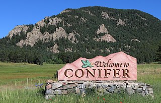
Conifer is an unincorporated community in Jefferson County, Colorado, United States. Conifer is located along U.S. Route 285 in the foothills west of Denver.
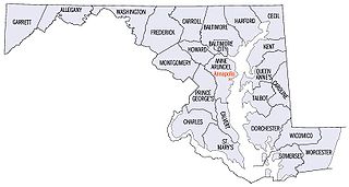
There are more than 1,500 properties and districts listed on the National Register of Historic Places in the U.S. State of Maryland. Each of the state's 23 counties and its one county-equivalent has at least 20 listings on the National Register.
Highland is an unincorporated community and census-designated place in Howard County, Maryland, United States. As of the 2020 census it had a population of 1,133. It uses the 20777 zip code.
The Snicker's Gap Turnpike was a turnpike road in the northern part of the U.S. state of Virginia. Part of it is now maintained as State Route 7, a primary state highway, but the road between Aldie and Bluemont in Loudoun County, via Mountville, Philomont, and Airmont, is a rural Virginia Byway known as Snickersville Turnpike, and includes the about 180-year-old Hibbs Bridge over Beaverdam Creek. This turnpike replaced, in part, the first toll road in the United States, which consisted of two roads from Alexandria northwest into the Shenandoah Valley.

The Buckeystown Historic District includes the majority of the small town of Buckeystown, Maryland, an unincorporated community located in Frederick County, Maryland, USA. It is named for George Buckey, a tanner, and his brother, John Buckey, a blacksmith and tavern owner. Buckeystown is on the U.S National Register of Historic Places and the Maryland Civil War Trail due to its rich history and beautiful examples of Queen Anne and Victorian style houses, along with a small commercial center. Each historic home has a plaque indicating the year built, the earliest being circa 1780. There are also several historical information plaques installed along the main street.

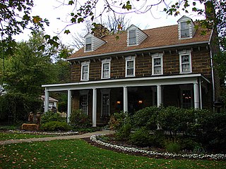
Roberts Inn, is a historic home and farm located at Cooksville, Howard County, Maryland. The complex consists of a 2+1⁄2-story stuccoed stone house with a reconstructed log wing built about 1808, and several 19th- to early-20th-century agricultural outbuildings, including a frame bank barn, a frame ground barn, a tile dairy, and a frame silo. The construction of the house coincided with the extension of the National Pike through the Cooksville area. Documentary and architectural evidence supports its use as a turnpike tavern from an early date. Tradition holds that Marquis de Lafayette breakfasted at Roberts Inn during his 1824 tour of America.

Johnsville is an unincorporated community in Frederick County, Maryland, United States. It is located approximately halfway between Libertytown and Union Bridge along Maryland Route 75. The Kitterman-Buckey Farm was listed on the National Register of Historic Places in 2005.
New London is an unincorporated community in Frederick County, Maryland, United States. Thomas Maynard House was listed on the National Register of Historic Places in 1979.
Glenwood is an unincorporated community in Howard County, Maryland, United States. It is located between Baltimore and Washington, D.C., therefore attracting commuters to those employment centers. The community features acres of open space and is districted to Bushy Park Elementary, Glenwood and Folly Quarter Middle, and Glenelg High schools. Union Chapel was listed on the National Register of Historic Places in 1975 and Round About Hills was added in 2008. The population in 2020 was approximately 3,416.

Round About Hills or Peacefields is a historic slave plantation home located at Glenwood, Howard County, Maryland. An alternate address for this house is 14581 McClintock Drive, Glenwood, Maryland. It was built about 1773 on a 266-acre land patent and consists of a 1+1⁄2-story frame house with a stone end. Thomas Beale Dorsey inherited the property in 1794 then exchanged his interest in the plantation with Thomas Cook's stagecoach wayside town Cooksville.

Mortonville is an unincorporated area and historic hamlet in Chester County, Pennsylvania, United States, situated on the eastern bank of the West Branch Brandywine Creek. It consists of approximately one-half dozen structures, two of which are on the National Register of Historic Places: the Mortonville Hotel, and the 12.5-foot-long (3.8 m) "Bridge in East Fallowfield Township" which crosses a mill race a few feet east of a larger bridge. The larger bridge, known as the Mortonville Bridge, was also listed on the NRHP until 2010, when it was delisted following a renovation. The two bridges are in East Fallowfield Township, while most other structures are in Newlin Township.
Hill's Tavern is a historic building in Scenery Hill, Pennsylvania. It was heavily damaged by a fire that started shortly before midnight on August 17, 2015. For a period in the early 1900s, the inn was known as Central Hotel. Now called the Century Inn, it has been claimed to have been the oldest tavern in continuous use on the National Road, until the fire brought an end to its 221 years of continuous operation.
Inwood is an unincorporated community in Howard County, Maryland, United States. The crossroads settlement was settled around Woodlawn, home of Dr. Edwin Warfield, which has been removed for the Gary J. Arthur Community Center and Cooksville Library. The town once featured a general store, blacksmith shop and residential homes. The neighborhood postal service is now consolidated around Cooksville. Inwood is a very small historic town located between Cooksville and Glenwood.

Thornton is an unincorporated community spanning Thornbury Township, Concord Township and Middletown Township in Delaware County, Pennsylvania, United States.
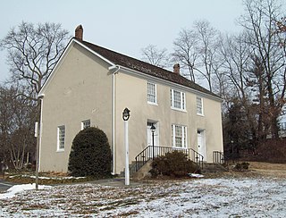
The Red House Tavern is located in Cooksville in Howard County, Maryland, United States. It was situated midway along the Old Frederick Road between Baltimore and Frederick, used as a rest stop for travelers. The house is the birthplace of Thomas Cook born in 1768, who founded Cooksville in 1802.
Pen Mar is an unincorporated community in Washington County, Maryland, and Franklin County, Pennsylvania, United States. It is one of the border towns in the United States with a portmanteau name. Pen Mar came to prominence as a resort in the 20th century after the construction of Pen Mar Park by the Western Maryland Railway. While the resort has long been dismantled, the area still has some significance in Maryland, since it is the northern starting point for the Maryland section of the Appalachian Trail.

Harmony Grove is a ghost town located close to U.S. Route 15, north of Frederick (city) in Frederick County, Maryland. Harmony Grove is considered part of the Piedmont region of Maryland.
References
- ↑ U.S. Geological Survey Geographic Names Information System: Cooksville (Populated Place)
- ↑ Seeking Freedom The History of the Underground Railroad in Howard County. p. 54.
- ↑ Barbara Feaga. Howard's Roads to the Past. p. 42.
- ↑ "Checklist of Maryland Post Offices" (PDF). Smithsonian National Postal Museum. Archived from the original (PDF) on May 18, 2014. Retrieved May 17, 2014.
- ↑ "National Register Information System". National Register of Historic Places . National Park Service. April 15, 2008.
- ↑ Earl Arnett; Robert J. Brugger; Edward C. Papenfuse. Maryland: A New Guide to the Old Line State. p. 426.
Municipalities and communities of Howard County, Maryland, United States | ||
|---|---|---|
| CDPs |  | |
| Villages | ||
| Unincorporated communities |
| |
| Ghost town | ||
| Footnotes | ‡This populated place also has portions in an adjacent county or counties | |
39°19′12″N77°01′14″W / 39.32000°N 77.02056°W