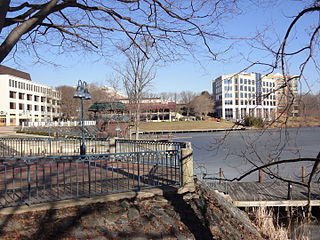
Columbia is a census-designated place in Howard County, Maryland, United States. It is a planned community consisting of 10 self-contained villages. The census-designated place had a population of 104,681 at the 2020 census, making it the second most populous community in Maryland after Baltimore. Columbia, located between Baltimore and Washington, D.C., is officially part of the Baltimore metropolitan area.

North Laurel is a census-designated place (CDP) in Howard County, Maryland, United States. The published population was 4,474 at the 2010 census. This population was substantially less than the CDP's population in 2000, and was the result of an error in defining the boundary prior to tabulation and publication of 2010 Census results. The corrected 2010 Census population is 20,259. North Laurel is adjacent to the City of Laurel, which is located across the Patuxent River in Prince George's County.

The Patuxent River is a tributary of the Chesapeake Bay in the state of Maryland. There are three main river drainages for central Maryland: the Potomac River to the west passing through Washington, D.C., the Patapsco River to the northeast passing through Baltimore, and the Patuxent River between the two. The 908-square-mile (2,352 km2) Patuxent watershed had a rapidly growing population of 590,769 in 2000. It is the largest and longest river entirely within Maryland, and its watershed is the largest completely within the state.

Clarksville is an unincorporated community in Howard County, Maryland; the second highest-earning county in the United States according to the U.S. Census Bureau. The community is named for William Clark, a farmer who owned much of the land on which the community now lies and served as a postal stop that opened on the 4th of July 1851.

Savage is an unincorporated community and census-designated place located in Howard County, Maryland, United States, approximately 18 miles (29 km) south of Baltimore and 21 miles (34 km) north of Washington, D.C. It is situated close to the city of Laurel and to the planned community of Columbia. As of the 2020 census, it had a population of 7,542. The former mill town is a registered historic place, and has several original buildings preserved within and around the Savage Mill Historic District.

Kings Contrivance is a village in the planned community of Columbia, Maryland, United States and is home to approximately 11,000 residents. It is Columbia's southernmost village, and was the eighth of Columbia's ten villages to be developed. Kings Contrivance consists of the neighborhoods of Macgill's Common, Huntington and Dickinson, and includes single-family homes, townhouses, apartments and a Village Center.
Oakland Mills is one of the 10 villages in Columbia, Maryland, United States. It is located immediately east of Town Center, across U.S. Route 29.
Hickory Ridge is one of the 10 villages in Columbia, Maryland, United States, located to the west of the Town Center with a 2014 population of 13,000 in 4,659 housing units. The village overlays the former postal community of Elioak. It was first occupied in 1974. Neighborhoods in the village are Hawthorn, Clary's Forest, and Clemens Crossing. The name Hickory Ridge is derived from the 1749 estate "Hickory Ridge" in nearby Highland, which later became the family home of the nephew of hospital and university founder Johns Hopkins.

Maryland Route 175 is a state highway in the U.S. state of Maryland. The highway runs 17.01 miles (27.37 km) from Little Patuxent Parkway in Columbia east to MD 3 in Millersville. MD 175 is a major highway through the large unincorporated community of Columbia; the highway connects U.S. Route 29 next to Columbia Town Center with Interstate 95 (I-95) and an industrial area on the eastern side of Howard County. MD 175 also connects Fort Meade with Jessup and Odenton in western Anne Arundel County, where it links MD 295 and MD 32 with the eastern part of the U.S. Army base.
Long Reach, one of ten villages composing Columbia, Maryland, United States, is found in the northeast part of Columbia along Maryland Route 108. Started in 1971, it is one of the oldest villages, and comprises four neighborhoods: Jeffers Hill, Kendall Ridge, Locust Park, and Phelps Luck. The village, with an approximate population of 15,600, is governed by five elected village board members through "Long Reach Community Association, Inc." The Village Office is located in Stonehouse, the community center, which opened in 1974.

Maryland Route 108 is a state highway in the U.S. state of Maryland. The highway runs 34.23 miles (55.09 km) from MD 27 in Damascus east to MD 175 in Columbia. MD 108 is an S-shaped highway that winds through the northern Montgomery County and central Howard County. The highway connects the Montgomery County communities of Laytonsville, Olney, Sandy Spring, and Ashton with the Howard County villages of Highland and Clarksville. MD 108 serves as the northern edge of Columbia and connects several of the planned community's suburban villages.
Dorsey's Search is a parcel of land patented by John Dorsey of Hockley-in-the-hole (1645–1714) in Baltimore County. The 479-acre (194 ha) property adjacent to the north branch of the Patuxent river was surveyed by Richard Beard in December 1684, and granted to Dorsey in March 1696. The property lying between "Long Reach" and "Elk Ridge" was resurveyed in March 1723 to include 750 acres (300 ha). After several generations of inheritance, a series of legal disputes were held over the land by Rezin Hammond and Richard Ridgley in 1820. In 1827 the property exchanged hands to Robert Oliver, builder of Oakland Mill, who combined it with multiple properties totaling 2,300 acres (930 ha). George Gaither acquired the property in 1838. John Dorsey's grandson, "Patuxent" John Dorsey of "Dorsey's Search" built Dorsey Hall at the site.
Owen Brown is one of the ten villages in Columbia, Maryland, United States, established in 1972. Neighborhoods in the village include Dasher Green, Elkhorn and Hopewell. Owen Brown lies south and east of the town center.

Harper's Choice is one of the ten villages that comprise Columbia, Maryland, United States. It lies in the northwest part of Columbia and consists of the neighborhoods of Longfellow, Swansfield, and Hobbit's Glen and had a December 1998 population of 8,695.
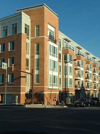
Town Center is one of the ten villages in Columbia, Maryland, United States, first occupied in 1974. The Town Center is a non-contiguous, diverse area, and the most urban-like, ranging from multi-level high density apartments, homes and office buildings to single family homes.
The Middle Patuxent Environmental Area (MPEA) is a 1,021-acre (4.13 km2) wildlife area in Clarksville, Maryland and operated by the Howard County Department of Recreation and Parks. It is located next to the River Hill village in the town of Columbia, Maryland, in the United States. The MPEA was created in 1996 for educational, research, and recreational purposes.
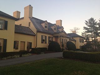
The Belmont Estate, now Belmont Manor and Historic Park, is a former plantation located at Elkridge, Howard County, Maryland, United States. Founded in the 1730s and known in the Colonial period as "Moore's Morning Choice", it was one of the earliest forced-labor farms in Howard County, Maryland. Its 1738 plantation house is one of the finest examples of Colonial Georgian architectural style in Maryland.
Atholton is an unincorporated community in Howard County, Maryland, United States. A postal office operated from May 26, 1897, to November 1900 and again from 1903 to July 1917.
The Alpha Ridge Landfill is a municipal solid waste landfill located in Marriottsville, Maryland, once known as the postal town of Alpha, Maryland.
River Hill Farm is a historic slave plantation located in Clarksville in Howard County, Maryland, United States. River Hill Farm resided on a land tract patented as "Four Brothers Portion". The house was built in the 18th century out of field stone with stucco covering. Outbuilding included a slave quarters. The 500 acre property was the home of Major Henry Owings of Owingsville.

