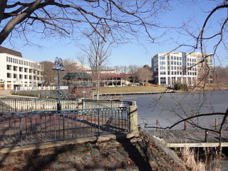
Columbia is a census-designated place in Howard County, Maryland, United States, and is one of the principal communities of the Baltimore–Washington metropolitan area. It is a planned community consisting of 10 self-contained villages.

Guilford is an unincorporated community located in Howard County in the state of Maryland. The location is named after the Guilford Mill. Guilford is near Kings Contrivance, one of the nine "villages" of Columbia.

River Hill is the last and westernmost village to be developed in the town of Columbia, Maryland, United States, though some residents maintain addresses in Clarksville. The village is home to 6,520 residents in 2,096 housing units in 2014. The area was used as a game preserve by James Rouse to entertain clients and personal hunting during the buildout of the Columbia project. In 1976, County Executive Edward L. Cochran selected the 784-acre parcel owned by Howard Research and Development for an alternate location for a county landfill; a task force selected Alpha Ridge Landfill instead. Residential construction started in 1990. It is bounded by Maryland Route 108 and Maryland Route 32, and is centered on Trotter Road. The village is divided into two neighborhoods: Pheasant Ridge and Pointers Run, with about 6,500 residents.
Oakland Mills is one of the 10 villages in Columbia, Maryland, United States. It is located immediately east of Town Center, across U.S. Route 29.
Long Reach, one of ten villages composing Columbia, Maryland, United States, is found in the northeast part of Columbia along Maryland Route 108. Started in 1971, it is one of the oldest villages, and comprises four neighborhoods: Jeffers Hill, Kendall Ridge, Locust Park, and Phelps Luck. The village, with an approximate population of 15,600, is governed by five elected village board members through "Long Reach Community Association, Inc." The Village Office is located in Stonehouse, the community center, which opened in 1974.
The Howard County Public School System (HCPSS) is the school district that manages and runs the public schools of Howard County, Maryland. It operates under the supervision of an elected, eight-member Board of Education. Dr. Chao Wu is the Chairman of the Board. Michael J. Martirano has served as the Superintendent since May 2017.
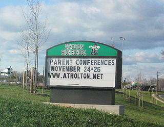
Atholton High School is a high school in Columbia, Maryland, United States and is a part of the Howard County public school system. The school hosts an Army JROTC program. The school mascot is the Raider.

Glenelg is an unincorporated community in Howard County, Maryland, United States. It is located in the 21737 zip code, and is part of the 410 area code. It is the home town of Glenelg High School.

The Maryland Sheep and Wool Festival is the largest and longest-running showcase of domestic sheep and wool in the United States. The 2010 festival was the 37th consecutive. It is held at the Howard County Fairgrounds in West Friendship, Maryland.
Dayton is an unincorporated community located in Howard County, Maryland, United States.

The Howard County Sheriff's Office (HCSO) is a law enforcement organization which acts as the enforcement arm of the Howard County court system and services Howard County, Maryland, population 328,200. Its mission centers around providing judicial enforcement and physical security for the Circuit Court. The department is a secondary law enforcement agency as police services are mostly provided by the larger, better-known Howard County Police Department while the county jail is run by the Howard County Department of Corrections. However, Sheriff's deputies are fully certified law enforcement officers with the same authority as any police officer in the state of Maryland. They assist county police officers with calls for service when requested or needed.

The Oakland Mills Blacksmith House and Shop, also known as Felicity, is a historic property at 5471 Old Columbia Road in Oakland Mills, Maryland.
Atholton is an unincorporated community in Howard County, Maryland, United States. A postal office operated from May 26, 1897, to November 1900 and again from 1903 to July 1917.
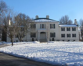
Oakland or Oakland Manor is a Federal style stone manor house commissioned in 1810 by Charles Sterrett Ridgely in the Howard district of Anne Arundel County Maryland. The lands that became Oakland Manor were patented by John Dorsey as "Dorsey's Adventure" in 1688 which was willed to his grandson Edward Dorsey. In 1785, Luther Martin purchased properties named "Dorsey's Adventure", "Dorsey's Inheritance", "Good for Little", "Chew's Vineyard", and "Adam the First" to make the 2300 acre "Luther Martin's Elkridge Farm".

The Simpsonville Mill is a historic pre-colonial mill complex in Simpsonville, Maryland, part of the Columbia, Maryland land development.
Elioak is an unincorporated community in Howard County, Maryland, United States. It was the home of the "Pushpin Farm", a 200-acre slave plantation purchased in 1724 in the Howard District of Anne Arundel County by Col. Edward Dorsey and which is the site of many prominent Dorsey family graves. The postal community was named after the Elioak plantation built by Owen Dorsey, Judge of the Baltimore Orphans' Court. A postal office operated in the community from 12 June 1893 to 15 September 1922. Local farm orchards were known for prize winning apples and pears. Local families such as the Kahler, Miller, and Worthington claimed Elioak as home while they served in World War I. After the war, the name fell out of use.
Florence is an unincorporated community in Howard County, Maryland, United States. A post office operated in Florence between June 17, 1868, and March 31, 1906. Governor Edwin Warfield taught in the neighborhood one room schoolhouse.
Arlington is a historic slave plantation located in Columbia, Howard County, Maryland, now part of the Fairway Hills Golf Course.
Ivory is an unincorporated community located at the northwest tip of Howard County, Maryland, United States. It is located between modern Glenelg and West Friendship.
Inwood is an unincorporated community in Howard County, Maryland, United States. The crossroads settlement was settled around Woodlawn, home of Dr. Edwin Warfield, which has been removed for the Gary J. Arthur Community Center and Cooksville Library. The town once featured a general store, blacksmith shop and residential homes. The neighborhood postal service is now consolidated around Cooksville. Inwood is a very small historic town located between Cooksville and Glenwood.

