Related Research Articles

Eldersburg is an unincorporated community and census-designated place (CDP) in Carroll County, Maryland, United States. The population was 30,531 at the 2010 census.

Clarksville is an unincorporated community in Howard County, Maryland; the second highest-earning county in the United States according to the U.S. Census Bureau. The community is named for William Clark, a farmer who owned much of the land on which the community now lies and served as a postal stop that opened on the 4th of July 1851.

River Hill is the last and westernmost village to be developed in the town of Columbia, Maryland, United States, though some residents maintain addresses in Clarksville. The village is home to 6,520 residents in 2,096 housing units in 2014. The area was used as a game preserve by James Rouse to entertain clients and personal hunting during the buildout of the Columbia project. In 1976, County Executive Edward L. Cochran selected the 784-acre parcel owned by Howard Research and Development for an alternate location for a county landfill; a task force selected Alpha Ridge Landfill instead. Residential construction started in 1990. It is bounded by Maryland Route 108 and Maryland Route 32, and is centered on Trotter Road. The village is divided into two neighborhoods: Pheasant Ridge and Pointers Run, with about 6,500 residents.
Oakland Mills is one of the 10 villages in Columbia, Maryland, United States. It is located immediately east of Town Center, across U.S. Route 29.
Hickory Ridge is one of the 10 villages in Columbia, Maryland, United States, located to the west of the Town Center with a 2014 population of 13,000 in 4,659 housing units. The village overlays the former postal community of Elioak. It was first occupied in 1974. Neighborhoods in the village are Hawthorn, Clary's Forest, and Clemens Crossing. The name Hickory Ridge is derived from the 1749 estate "Hickory Ridge" in nearby Highland, which later became the family home of the nephew of hospital and university founder Johns Hopkins.
West Friendship is a semi-rural unincorporated community in western Howard County, Maryland, United States. West Friendship is located at the junction of Interstate 70 and Maryland Route 32. Frederick Road is a main thoroughfare.
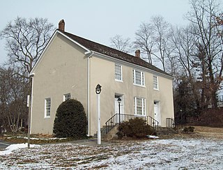
Highland is an unincorporated community and census-designated place in Howard County, Maryland, United States. As of the 2020 census it had a population of 1,133. It uses the 20777 zip code.
Dayton is an unincorporated community located in Howard County, Maryland, United States.
Glenwood is an unincorporated community in Howard County, Maryland, United States. It is located between Baltimore and Washington, D.C., therefore attracting commuters to those employment centers. The community features acres of open space and is districted to Bushy Park Elementary, Glenwood and Folly Quarter Middle, and Glenelg High schools. Union Chapel was listed on the National Register of Historic Places in 1975 and Round About Hills was added in 2008. The population in 2020 was approximately 3,416.
Simpsonville is an unincorporated community in Howard County, Maryland, United States.
Atholton is an unincorporated community in Howard County, Maryland, United States. A postal office operated from May 26, 1897, to November 1900 and again from 1903 to July 1917.
Alberton is an unincorporated community in Howard County, Maryland, United States. A postal office operated in the community from 3 February 1854 to 1 March 1943.
Alpha is an unincorporated community in Howard County, Maryland, United States. A postal office operated from 27 February 1884 to 15 June 1915.
Clarkson is an unincorporated community in Howard County, Maryland, United States. A postal office operated in the community from September 14, 1889, to October 31, 1931. Clarkson was the site of strategic simulations by the U.S. Army in 1922 training manuals.
Elioak is an unincorporated community in Howard County, Maryland, United States. It was the home of the "Pushpin Farm", a 200-acre slave plantation purchased in 1724 in the Howard District of Anne Arundel County by Col. Edward Dorsey and which is the site of many prominent Dorsey family graves. The postal community was named after the Elioak plantation built by Owen Dorsey, Judge of the Baltimore Orphans' Court. A postal office operated in the community from 12 June 1893 to 15 September 1922. Local farm orchards were known for prize winning apples and pears. Local families such as the Kahler, Miller, and Worthington claimed Elioak as home while they served in World War I. After the war, the name fell out of use.
Elysville is an unincorporated community in Howard County, Maryland, United States. A postal stop operated between February 22, 1834, and February 3, 1854.
Florence is an unincorporated community in Howard County, Maryland, United States. A post office operated in Florence between June 17, 1868, and March 31, 1906. Governor Edwin Warfield taught in the neighborhood one room schoolhouse.
Gary is an unincorporated community in Howard County, Maryland, United States. A postal stop operated between February 2, 1892, and June 13, 1918. The town is located at the crossroads of Sharp and Tridelphia Road near modern Woodbine, Maryland.
Ivory is an unincorporated community located at the northwest tip of Howard County, Maryland, United States. It is located between modern Glenelg and West Friendship.

Guilford Road is a historic road north of Savage, Maryland that traverses Anne Arundel and Howard Counties in an area that was first settled by English colonists in the mid-1600s. Today's Guilford road is a series of disconnected segments bisected multiple times by the construction of Maryland Route 32.
References
- ↑ "Checklist of Maryland Post Offices" (PDF). Smithsonian National Postal Museum. July 12, 2007. Archived from the original (PDF) on August 15, 2013. Retrieved May 17, 2014.
- ↑ "Md. Judge Allows Power Line". The Washington Post . June 5, 1990.
