Dismal Swamp Canal

Last updated

Dismal Swamp Canal
Great Dismal Swamp Canal.jpg
A sailboat on the Dismal Swamp Canal
DismalSwampCanal.png
Path of the canal
LocationRuns between Chesapeake, Virginia, and South Mills, North Carolina
Coordinates 36°33′24″N76°22′50″W / 36.55667°N 76.38056°W / 36.55667; -76.38056
Area1,203 acres (487 ha)
Built1793–1805
ArchitectDismal Swamp Canal Co.; US Army Corps of Engineers
MPS Dismal Swamp Canal and Associated Development, Southeast Virginia and Northeast North Carolina MPS
NRHP reference No. 88000528 [1]
VLR No.131-0035
Significant dates
Added to NRHPJune 06, 1988
Designated VLRAugust 16, 1994 [2]

The Dismal Swamp Canal is a canal located along the eastern edge of the Great Dismal Swamp in Virginia and North Carolina in the United States. Opened in 1805, it is the oldest continually operating man-made canal in the United States. It is part of the Intracoastal Waterway.

Contents

History

Map of the Dismal Swamp Canal, drawn by civil engineer D. S. Walton, 1867 Map of the Dismal Swamp Canal 1867.jpg
Map of the Dismal Swamp Canal, drawn by civil engineer D. S. Walton, 1867
Deep Creek Lock, located in Deep Creek, Virginia, separates the salt water of Deep Creek from the fresh water of Dismal Swamp Canal Deep Creek Locks (10019399395).jpg
Deep Creek Lock, located in Deep Creek, Virginia, separates the salt water of Deep Creek from the fresh water of Dismal Swamp Canal

In the Colonial period, water transportation was the lifeblood of the North Carolina sounds region and the Tidewater areas of Virginia. The landlocked sounds were entirely dependent upon poor overland tracks or shipment along the treacherous Carolina coast to reach further markets through Norfolk, Virginia. In May 1763, George Washington made his first visit to the Great Dismal Swamp and suggested draining it and digging a north–south canal through it to connect the waters of the Chesapeake Bay in Virginia and Albemarle Sound in North Carolina. As the first president, Washington agreed with Virginia Governor Patrick Henry that canals were the easiest answer for an efficient means of internal transportation and urged their creation and improvement.

In 1784, the Dismal Swamp Canal Company was created. Work was started in 1793. The canal was dug completely by hand; most of the labor was done by slaves rented from nearby landowners. It took approximately 12 years of construction under highly unfavorable conditions to complete the 22-mile long waterway, which opened in 1805. [3] At about the time the canal opened, the Dismal Swamp Hotel was built astride the state line on the west bank. [4] It was a popular spot for lover's trysts as well as duels; the winner was rarely arrested as the dead man, as well as the crime, were in another state. As the state line split the main salon, the hotel was quite popular with gamblers who would simply move the game to the opposite side of the room with the arrival of the sheriff from the other jurisdiction. No trace of the hotel can be found today. [ citation needed ]

Tolls were charged for maintenance and improvements. In 1829, the channel was deepened. The waterway was an important route of commerce in the era before railroads, such as the Petersburg Railroad, and highways became major transportation modes.

American Civil War

During the American Civil War (1861–1865) the canal was in an important strategic position for Union and Confederate forces. In April, 1862, upon learning of rumors that the canal would be used to help the Confederate ironclad escape from Hampton Roads to the Albemarle Sound in North Carolina, Union General Ambrose E. Burnside sent General Jesse L. Reno from Roanoke Island to destroy the Culpepper Locks near South Mills on the Dismal Swamp Canal. Reno's 3,000 troops disembarked from their transports near Elizabeth City on April 18.

The Union troops advanced the following morning on an exhausting march toward South Mills where Confederate Colonel Ambrose R. Wright posted his 900 men to command the road to the town. Reno encountered Wright's position at noon. The Confederates' determined fighting continued for four hours until their artillery commander, Captain W. W. McComas, was killed. To avoid being flanked, Wright retired behind Joy's Creek, two miles away. General Reno did not pursue them because of his losses and his troops' exhaustion. That evening he heard a rumor that Confederate reinforcements were arriving from Norfolk and ordered a silent march back to the transports near Elizabeth City. The losses were estimated at 114 Union and 25 Confederate soldiers.

The Battle of South Mills was the only battle action near the canal. However, wartime activity left the canal in a terrible state of repair. The repairs and maintenance needed by the canal made travel difficult.

Post-war, 20th century

In 1892, Lake Drummond Canal and Water Company launched rehabilitation efforts and once again, a steady stream of vessels carrying lumber, shingles, farm products, and passengers made the canal a bustling interstate thoroughfare.

By the 1920s, improvements in other modes of transportation meant another downturn for the canal, and commercial traffic had subsided except for passenger vessels. In 1929 it was sold to the federal government for $500,000 (~$6.28 million in 2021). As recreational boating became popular in the mid-20th century, the canal became an important link to provide shelter from the brutal forces of the treacherous Atlantic Coast line off the Carolinas and the Virginia capes.

Current use

In modern times, the U.S. Army Corps of Engineers operates and maintains the canal. The Dismal Swamp Canal is one of two inland routes connecting the Chesapeake Bay and the Albemarle Sound. About 2,000 recreational boaters transit the canal each year as they pass through the Intracoastal Waterway.

The canal was closed to boating traffic in October 2016 after Hurricane Matthew caused a flash flood in Chesapeake, Virginia. The runoff from this storm filled the canal with silt and sand, making it impassable. The necessary dredging for navigation on the canal was completed November 2017 to a depth of approximately five feet, and reopened for a short time before closing again, due to being inundated with duckweed. The duckweed clogs the intakes on power boats, quickly causing them to overheat. The Elizabeth River runs almost parallel to the canal, and was not affected by the 2016 flash flood, being much wider and much deeper than the canal. As of March 2018, the canal has been reopened by the U.S. Army Corps of Engineers. The ICW has remained open during all of this via the Elizabeth River and the North Landing River.

The Virginia portion of the canal was located in Norfolk County, which today is the city of Chesapeake, where the northern portion of the canal at Deep Creek connects with the Southern Branch Elizabeth River.

The southern end of the canal leads to the Albemarle Sound. The Dismal Swamp Canal Visitor Center is the only visitor center in the continental U. S. greeting visitors by both a major highway and a historic waterway. It is located in Camden County, North Carolina, on scenic U.S. Highway 17 three miles south of the Virginia/North Carolina border.

The canal is listed on the National Register of Historic Places and has been designated a National Historic Civil Engineering Landmark. The historic canal is now recognized as part of the Underground Railroad and along with the Great Dismal Swamp, is noted as a former sanctuary for runaway slaves seeking freedom.

The East Coast Greenway, a 3,000-mile long system of trails connecting Maine to Florida, runs along part of the Dismal Swamp Canal Trail.

Boaters visiting the swamp in the Fall need to be very conscious of the level of duckweed clogging the waterway, which can clog water intakes on power boat engines and systems.

See also

Related Research Articles

<span class="mw-page-title-main">Chesapeake, Virginia</span> Independent city in Virginia, United States

Chesapeake is an independent city in Virginia, United States. At the 2020 census, the population was 249,422, making it the second-most populous city in Virginia, the tenth largest in the Mid-Atlantic, and the 90th-most populous city in the United States.

<span class="mw-page-title-main">Pasquotank County, North Carolina</span> County in North Carolina, United States

Pasquotank County is a county located in the U.S. state of North Carolina. As of the 2020 census, the population was 40,568. Its county seat is Elizabeth City. The county was originally created as Pasquotank Precinct and gained county status in 1739. Pasquotank County is part of the Elizabeth City, NC Micropolitan Statistical Area, which is also included in the Virginia Beach-Norfolk, VA-NC Combined Statistical Area.

<span class="mw-page-title-main">Gates County, North Carolina</span> County in North Carolina, United States

Gates County is a county located in the northeastern portion of the U.S. state of North Carolina, on the border with Virginia. As of the 2020 census, the population was 10,478. Its county seat is Gatesville. Gates County is included in the Virginia Beach-Norfolk-Newport News, VA-NC Metropolitan Statistical Area. It is part of the Albemarle Sound area of the Inner Banks.

<span class="mw-page-title-main">Camden County, North Carolina</span> County in North Carolina, United States

Camden County, officially Elizabeth City–Camden County, is a consolidated city-county located in the U.S. State of North Carolina. As of the 2020 census, the population was 10,335, making it the fourth-least populous county in North Carolina. Its county seat is Camden. Camden County is part of the Elizabeth City, NC Micropolitan Statistical Area, which is also included in the Virginia Beach-Norfolk, VA-NC Combined Statistical Area.

<span class="mw-page-title-main">Elizabeth City, North Carolina</span> City in North Carolina, United States

Elizabeth City is a city in Pasquotank and Camden counties, North Carolina, United States. As of the 2020 census, it had a population of 18,629. Elizabeth City is the county seat and most populous city of Pasquotank County. It is the cultural, economic and educational hub of the sixteen-county Historic Albemarle region of northeastern North Carolina.

<span class="mw-page-title-main">Intracoastal Waterway</span> Inland waterway along the Atlantic and Gulf coasts of the United States

The Intracoastal Waterway (ICW) is a 3,000-mile (4,800 km) inland waterway along the Atlantic and Gulf of Mexico coasts of the United States, running from Massachusetts southward along the Atlantic Seaboard and around the southern tip of Florida, then following the Gulf Coast to Brownsville, Texas. Some sections of the waterway consist of natural inlets, saltwater rivers, bays, and sounds, while others are artificial canals. It provides a navigable route along its length without many of the hazards of travel on the open sea.

<span class="mw-page-title-main">Albemarle Sound</span> An estuary on the coast of North Carolina, United States

Albemarle Sound is a large estuary on the coast of North Carolina in the United States located at the confluence of a group of rivers, including the Chowan and Roanoke. It is separated from the Atlantic Ocean by the Currituck Banks, a barrier peninsula upon which the town of Kitty Hawk is located, at the eastern edge of the sound, and part of the greater Outer Banks region. Roanoke Island is situated at the southeastern corner of the sound, where it connects to Pamlico Sound. Much of the water in the Albemarle Sound is brackish or fresh, as opposed to the saltwater of the ocean, as a result of river water pouring into the sound.

<span class="mw-page-title-main">Elizabeth River (Virginia)</span> River in Virginia

The Elizabeth River is a 6-mile-long (10 km) tidal estuary forming an arm of Hampton Roads harbor at the southern end of Chesapeake Bay in southeast Virginia in the United States. It is located along the southern side of the mouth of the James River, between the cities of Portsmouth, Norfolk, and Chesapeake. Forming the core of the Hampton Roads harbor, it is heavily supported by its tributaries which depend upon it.

<span class="mw-page-title-main">Great Dismal Swamp</span> Swamp in Virginia and North Carolina, US

<span class="mw-page-title-main">Great Dismal Swamp National Wildlife Refuge</span> United States National Wildlife Refuge in Virginia

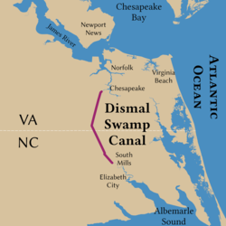
The Great Dismal Swamp National Wildlife Refuge was created in 1974 to help protect and preserve a portion of the Great Dismal Swamp, a marshy region on the Coastal Plain of southeastern Virginia and northeastern North Carolina between Norfolk, Virginia, and Elizabeth City, North Carolina in the United States. It is located in parts of the independent cities of Chesapeake and Suffolk in Virginia, and the counties of Camden, Gates, and Pasquotank in North Carolina.

CSS <i>Raleigh</i> (1861)

CSS Raleigh was originally a small, iron-hulled, propeller-driven towing steamer operating on the Albemarle and Chesapeake Canal. She was taken over by the State of North Carolina in May 1861, and transferred to the Confederate States the following July. Her commanding officer during 1861–1862 was Lieutenant Joseph W. Alexander. Her entire service was in coastal waters of North Carolina and Virginia and in the James River as part of the James River Squadron.

<span class="mw-page-title-main">Battle of South Mills</span> Battle of the American Civil War

The Battle of South Mills, also known as the Battle of Camden, took place on April 19, 1862 in Camden County, North Carolina as part of Union Army Maj. Gen. Ambrose E. Burnside's North Carolina expedition during the American Civil War.

<span class="mw-page-title-main">Battle of Roanoke Island</span> Battle of the American Civil War

The opening phase of what came to be called the Burnside Expedition, the Battle of Roanoke Island was an amphibious operation of the American Civil War, fought on February 7–8, 1862, in the North Carolina Sounds a short distance south of the Virginia border. The attacking force consisted of a flotilla of gunboats of the Union Navy drawn from the North Atlantic Blockading Squadron, commanded by Flag Officer Louis M. Goldsborough, a separate group of gunboats under Union Army control, and an army division led by Brig. Gen. Ambrose Burnside. The defenders were a group of gunboats from the Confederate States Navy, termed the Mosquito Fleet, under Capt. William F. Lynch, and about 2,000 Confederate soldiers commanded locally by Brig. Gen. Henry A. Wise. The defense was augmented by four forts facing on the water approaches to Roanoke Island, and two outlying batteries. At the time of the battle, Wise was hospitalized, so leadership fell to his second in command, Col. Henry M. Shaw.

<span class="mw-page-title-main">Transportation in Virginia</span> Overview of land sea and air transport systems in Virginia

Transportation in the Commonwealth of Virginia is by land, sea and air. Virginia's extensive network of highways and railroads were developed and built over a period almost 400 years, beginning almost immediately after the founding of Jamestown in 1607, and often incorporating old established trails of the Native Americans.

<span class="mw-page-title-main">Chesapeake and Albemarle Railroad</span>

The Chesapeake and Albemarle Railroad is a short-line railroad that operates 68 miles (109 km) of track from Chesapeake, Virginia to Edenton, North Carolina.

<span class="mw-page-title-main">Battle of Elizabeth City</span> 1862 battle of the American Civil War in North Carolina

The Battle of Elizabeth City of the American Civil War was fought in the immediate aftermath of the Battle of Roanoke Island. It took place on 10 February 1862, on the Pasquotank River near Elizabeth City, North Carolina. The participants were vessels of the U.S. Navy's North Atlantic Blockading Squadron, opposed by vessels of the Confederate Navy's Mosquito Fleet; the latter were supported by a shore-based battery of four guns at Cobb's Point, near the southeastern border of the town. The battle was a part of the campaign in North Carolina that was led by Major General Ambrose E. Burnside and known as the Burnside Expedition. The result was a Union victory, with Elizabeth City and its nearby waters in their possession, and the Confederate fleet captured, sunk, or dispersed.

<span class="mw-page-title-main">Deep Creek, Virginia</span> Unincorporated area in Virginia, United States

Deep Creek is a former unincorporated town of the former Norfolk County (extinct) which since 1963 has been located in the independent city of Chesapeake in the South Hampton Roads region of southeastern Virginia. Deep Creek is located on the original route of U.S. Highway 17, on a section now designated as U.S. Route 17 Business, and has been largely bypassed by modern highway improvements.

<span class="mw-page-title-main">Inner Banks</span>

The Inner Banks is a neologism made up by developers and tourism promoters to describe the inland coastal region of eastern North Carolina. Without historical precedent, the term "Inner Banks" is an early 21st-century construct that is part of an attempt to rebrand the mostly agrarian coastal plain east of I-95 as a more attractive region for visitors and retirees.

USS John L. Lockwood was a steamer acquired by the Union Navy during the American Civil War. She was needed by the Navy to be part of the fleet of ships to prevent blockade runners from entering ports in the Confederacy.

Burnside's North Carolina Expedition was a series of engagements fought along the North Carolina Coast between February and June 1862. The expedition was part of Winfield Scott's overall Anaconda Plan, which aimed at closing blockade-running ports inside the Outer Banks. The amphibious operation was carried out primarily by New England and North Carolina troops under Brig. Gen. Ambrose E. Burnside and assisted by the North Atlantic Blockading Squadron under Captain Louis M. Goldsborough.

References

  1. "National Register Information System". National Register of Historic Places . National Park Service. March 13, 2009.
  2. "Virginia Landmarks Register". Virginia Department of Historic Resources. Archived from the original on September 21, 2013. Retrieved June 5, 2013.
  3. Parramore, Thomas C. (2000). Norfolk: The First Four Centuries, p. 147. University of Virginia Press. ISBN   0-8139-1988-6.
  4. Forrest, William S. (1858). Historical and Descriptive Sketches of Norfolk and Vicinity, p. 483. Philadelphia: Lindsay and Blakiston.