The Hopewell tradition, also called the Hopewell culture and Hopewellian exchange, describes a network of precontact Native American cultures that flourished in settlements along rivers in the northeastern and midwestern Eastern Woodlands from 100 BCE to 500 CE, in the Middle Woodland period. The Hopewell tradition was not a single culture or society but a widely dispersed set of populations connected by a common network of trade routes.

Washington Township is one of the seventeen townships of Logan County, Ohio, United States. As of the 2020 census, the population was 3,351.

The Kolomoki Mounds is one of the largest and earliest Woodland period earthwork mound complexes in the Southeastern United States and is the largest in Georgia. Constructed from 350CE to 600CE, the mound complex is located in southwest Georgia, in present-day Early County near the Chattahoochee River.

An effigy mound is a raised pile of earth built in the shape of a stylized animal, symbol, religious figure, human, or other figure. The Effigy Moundbuilder culture is primarily associated with the years 550–1200 CE during the Late Woodland Period, although radiocarbon dating has placed the origin of certain mounds as far back as 320 BCE.

Union Township is one of the twelve townships of Champaign County, Ohio, United States. The 2020 census reported 2,112 people living in the township.

This is a list of the National Register of Historic Places listings in Champaign County, Ohio.

The Portsmouth Earthworks are a large prehistoric mound complex constructed by the Native American Adena and Ohio Hopewell cultures of eastern North America. The site was one of the largest earthwork ceremonial centers constructed by the Hopewell and is located at the confluence of the Scioto and Ohio Rivers, in present-day Ohio.

The Zimmerman Kame is a glacial kame and archaeological site in McDonald Township, Hardin County, Ohio, United States, near the community of Roundhead. A circular hill approximately 20 feet (6.1 m) in height, it was a commercial gravel pit for a time before being abandoned in the 1970s after artifacts of the ancient Glacial Kame culture of Native Americans were found at the site. Today, the kame is tree-covered and surrounded by farm fields; there are no obvious signs of its significance.

The Goodall focus was a Hopewellian culture from the Middle Woodland period peoples that occupied Western Michigan and northern Indiana from around 200 BCE to 500 CE. Extensive trade networks existed at this time, particularly among the many local cultural expressions of the Hopewell communities. The Goodall pattern stretched from the southern tip of Lake Michigan, east across northern Indiana, to the Ohio border, then northward, covering central Michigan, almost reaching to Saginaw Bay on the east and Grand Traverse Bay to the north. The culture is named for the Goodall site in northwest Indiana.

The Lake Ridge Island Mounds are a group of small hills in Logan County, Ohio, United States that have been thought to be Native American mounds. Located in an area of about 5 acres (2.0 ha) at the northern end on Lake Ridge Island in Indian Lake, the mounds are near the village of Russells Point in the southeastern corner of Stokes Township. State Route 368 passes a short distance to the east of the mounds, even weaving at one point to avoid them. The four mounds on the island are small, not reaching a height greater than 3 feet (0.91 m) or a diameter greater than 40 feet (12 m); they are small enough that they appear to be natural knolls. A report produced in the 1970s observed that the mounds were in "excellent" condition at the time, never having been disturbed by artifact seekers.

The Point Peninsula complex was an indigenous culture located in Ontario and New York from 600 BCE to 700 CE. Point Peninsula ceramics were first introduced into Canada around 600 BCE then spread south into parts of New England around 200 BCE. Some time between 300 BCE and 1 CE, Point Peninsula pottery first appeared in Maine, and "over the entire Maritime Peninsula." Little evidence exists to show that it was derived from the earlier, thicker pottery, known as Vinette I, Adena Thick, etc... Point Peninsula pottery represented a new kind of technology in North America and has also been called Vinette II. Compared to existing ceramics that were thicker and less decorated, this new pottery has been characterized by "superior modeling of the clay with vessels being thinner, better fired and containing finer grit temper." Where this new pottery technology originated is not known for sure. The origin of this pottery is "somewhat of a problem." The people are thought to have been influenced by the Hopewell traditions of the Ohio River valley. This influence seems to have ended about 250 CE, after which they no longer practiced burial ceremonialism.

This is a list of the National Register of Historic Places listings in Logan County, Ohio.
The Mann site is a Crab Orchard culture site located off Indian Mound Road in Mount Vernon, Posey County, Indiana. It was placed on the National Historic Register on October 1, 1974. Exotic ceramics and other artifacts found at the site reflect contact with Ohio Hopewell people, in addition to more distant peoples in the Southeast of the Swift Creek culture of the Georgia Piedmont and Gulf Coastal Plain.
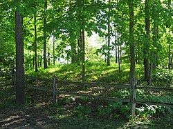
The Carl Potter Mound is a historic Native American mound in southern Champaign County, Ohio, United States. Located near Mechanicsburg, it lies on a small ridge in a pasture field in southeastern Union Township. In 1974, the mound was listed on the National Register of Historic Places as a potential archaeological site, primarily because of its use as a burial mound.
Indian Mound Reserve is a public country park near the village of Cedarville, Ohio, United States. Named for two different earthworks within its bounds — the Williamson Mound and the Pollock Works — the park straddles Massies Creek as it flows through a small canyon.

The Rocky Fork Park Site is an archaeological site in the southeastern part of the U.S. state of Ohio. Located in Rocky Fork State Park in eastern Highland County, the site's earthworks have been designated a historic site because of their archaeological importance.

The Pompano Beach Mound, located at Indian Mound Park in Pompano Beach, Florida, in Broward County, is a 100-foot (30 m) wide, 7-foot (2.1 m) tall oval Tequesta burial mound. It was listed on the National Register of Historic Places on April 17, 2014.
Wickiup Hill is a Native American archeological region near Toddville, in Linn County, Iowa. The area has the Wickiup Hill Outdoor Learning Center which was built where a Meskwaki village once stood. Wickiup Hill has been excavated by archeologists.