Naples Mound 8

Last updated

Naples Mound 8
Naples-Russel Mound 8.jpg
USA Illinois location map.svg
Red pog.svg
Location Pike County, Illinois
Nearest city Griggsville
Coordinates 39°41′36.9″N90°38′56″W / 39.693583°N 90.64889°W / 39.693583; -90.64889
Arealess than one acre
NRHP reference No. 75000671 [1]
Added to NRHPOctober 14, 1975

The Naples Mound 8 (also Naples-Russel Mound 8 or Illinois Archaeological Survey #PK 335) is a Havana Hopewell culture mound site located in Pike County, Illinois three miles east of the city of Griggsville. It is the largest mound on the bluff-top in the lower Illinois Valley. [2] The mound was given the name Naples Mound #8 in 1882. The mound was listed on the National Register of Historic Places in 1975.

Contents

First recorded visit by Mormon settlers

In May and June 1834, Joseph Smith led a Latter Day Saint group of 150 men known as Zion's Camp on a march from Kirtland, Ohio, to Jackson County, Missouri. [3] [2] On June 3, while passing through west-central Illinois three miles east of Griggsville, Illinois, some men discovered a large burial mound on the west side of the Illinois River one mile south of present-day Valley city. [4] Their report said that there were remains of bones on the surface and that when digging it up they found a skeleton about a foot beneath the surface, with a stone arrow point in the ribs. Through visions this was interpreted as a white Lamanite warrior named Zelph who was killed during a battle with the Nephites. They took the leg bones of "Zelph" away in Wilford Woodruff's wagon and reburied them near Liberty, Missouri, but the arrow head was retained. [5] The Zelph Mound incident was recorded by six men of Zion's Camp in their journals: Woodruff, Heber C. Kimball, Levi Hancock, George A. Smith, Moses Martin, and Reuben McBride. [6] [2] The "Zelph Mound incident" was formally recorded in church history from available sources in 1842 by church historian, Willard Richards. [7]

First recorded visits by local settlers

Illinois was made a state in 1818 and white settlers came in and opened some of the burial mounds in the former Native American lands. Judge John G. Henderson of Winchester, Illinois, was impressed by beautifully carved stone smoking pipes a friend showed him which were obtained from burial mounds in Naples, Illinois. Accordingly, he and a Mr. Merrill, in 1876, did some excavations and documentation of some of the Naples mounds in which were found a raccoon and a turtle pipe, copper axes, and human skeletal remains. [8] Henderson also mapped the location of fifteen mounds near Naples, including Naples Mound #8. [2] [9] A map he made shows Naples Mound #8 as being a mile south of Valley City, Illinois and across the Illinois River from Naples, Illinois. [8] Being impressed with mound #8, Henderson illustrated an Eagle pipe unearthed from the mound about 40 years earlier by a Daniel Burn, John W. Windsor and others. [10] [2] [9] In describing Naples Mound #8 Henderson states, "On the right bank of the Illinois river about 300 yards below [south of] Griggsville Landing, rises a lofty bluff fully 300 feet above the level of the river. On the summit is a beautiful, oval mound, 150 long, 92 feet wide in the middle, and 25 or 30 feet high. ... within a radius of 5 miles from Naples there are a least fifty mounds, very few of which have ever been opened". [10] After Henderson wrote an article describing the Naples mounds and the relics found in them, the Smithsonian Institution, in December 1879 began a thorough exploration of them, furnishing six laborers to help with the excavations. [11] Afterwards, Henderson authored the article describing the results in the Smithsonian Annual Report. [12]

Rediscovery of the Mound

Naples Mound ca 1880 Naples Mound 8 ca 1880.PNG
Naples Mound ca 1880

The mound was forgotten after 1882 and no records of visits have been found until 1974. Due to the Central Illinois Expressway bridge being planned across the Illinois River, the river bluffs were again visited by archaeologists. A team of graduate students from Northwestern University led by Archaeology Professor Jane E. Buikstra combed the bluffs of the Illinois River a mile South of Valley City, Illinois mapping burial mounds. [13] They located an extraordinarily large mound and were excited to inform local historian, Warren Winston, about it. James Bradley, a Mormon Historian from Utah, who had been searching for Zelph Mound for 25 years, visited Warren Winston the day after Professor Buikstra's visit and the connection was made. The Zelph Mound, was re-identified using historic journals, historic landmarks and mound surveys. [13] The archaeological name Naples Mound #8, which archaeologist Henderson had given it over ninety years earlier, was changed by Professor Buikstra in 1974 to Naples-Russell Mound #8 (RN8). The name "Russell" was added due to the mound being on private land owned by a Mr. Roy Russell. [2] [13] Shortly after that event, in 1975, Buikstra applied to have the mound placed on the National Register of Historic Places. [13] [9] Seven years later, in 1988, The State of Illinois purchased 280 acres of Illinois River frontage land, including the mound. [14]

Scientific investigation of the Mound

In 2001, the mound underwent an archeological investigation. What was identified as Burial 1 Skeleton 1 (QL-4904) was interred on the upper west side of the tumulus, and was one of the last burials in the mound. QL-4904 was thus determined to be the end use of the structure. By radiometric dating it was determined that QL-4904 was interred in 91 AD (Calibrated Range (2σ) AD 58-127). [15]

Previously archaeologists, after excavating in the Elizabeth Mounds and Napoleon Hollow for ten years where an expressway bridge was to be built, excavated the mound, located just a hundred and fifty yards to the north of the Elizabeth Mound group. [16] [17] [18] [9] A scientific excavation of RN8 was carried out in 1990 by The University of Illinois at Urbana-Champaign, in cooperation with the Center for American Archaeology at Kampsville, Illinois. [9] The dig was funded by the Illinois Department of Transportation and supervised by archaeologist Ken Farnsworth. The artifacts found during the excavation confirmed the mound to be a Hopewell burial mound, dating from 100 B.C. to 500 A.D. [19] [9] The artifacts are now located in the Illinois State Museum.[ citation needed ] The artifacts of the RN8 Mound were found to be from many parts of the eastern two thirds of United States or east of the Rocky Mountains, illustrating the wide trade network of the Hopewell culture.[ citation needed ] Photographs of the artifacts from NR8 have recently been published.[ citation needed ] The mound is located at the Roy Norbut Fish and Wildlife Area, overseen by the Illinois Department of Natural Resources. [2] [20]

See also

Related Research Articles

<span class="mw-page-title-main">Hopewell tradition</span> Ancient North American indigenous civilization

The Hopewell tradition, also called the Hopewell culture and Hopewellian exchange, describes a network of precontact Native American cultures that flourished in settlements along rivers in the northeastern and midwestern Eastern Woodlands from 100 BCE to 500 CE, in the Middle Woodland period. The Hopewell tradition was not a single culture or society but a widely dispersed set of populations connected by a common network of trade routes.

<span class="mw-page-title-main">Serpent Mound</span> Prehistoric effigy mound in Ohio, United States

The Great Serpent Mound is a 1,348-feet-long (411 m), three-feet-high prehistoric effigy mound located in Peebles, Ohio. It was built on what is known as the Serpent Mound crater plateau, running along the Ohio Brush Creek in Adams County, Ohio. The mound is the largest serpent effigy known in the world.

<span class="mw-page-title-main">Wickliffe Mounds</span> Archaeological site in Kentucky, US

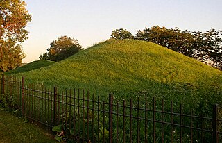
Wickliffe Mounds is a prehistoric, Mississippian culture archaeological site located in Ballard County, Kentucky, just outside the town of Wickliffe, about 3 miles (4.8 km) from the confluence of the Ohio and Mississippi rivers. Archaeological investigations have linked the site with others along the Ohio River in Illinois and Kentucky as part of the Angel phase of Mississippian culture. Wickliffe Mounds is controlled by the State Parks Service, which operates a museum at the site for interpretation of the ancient community. Listed on the National Register of Historic Places, it is also a Kentucky Archeological Landmark and State Historic Site.

<span class="mw-page-title-main">Hopewell Culture National Historical Park</span> United States national historical park

Hopewell Culture National Historical Park is a United States national historical park with earthworks and burial mounds from the Hopewell culture, indigenous peoples who flourished from about 200 BC to 500 AD. The park is composed of four separate sites open to the public in Ross County, Ohio, including the former Mound City Group National Monument. The park includes archaeological resources of the Hopewell culture. It is administered by the United States Department of the Interior's National Park Service.

<span class="mw-page-title-main">Moundville Archaeological Site</span> Archaeological site in Alabama, United States

Moundville Archaeological Site, also known as the Moundville Archaeological Park, is a Mississippian culture archaeological site on the Black Warrior River in Hale County, near the modern city of Tuscaloosa, Alabama. Extensive archaeological investigation has shown that the site was the political and ceremonial center of a regionally organized Mississippian culture chiefdom polity between the 11th and 16th centuries. The archaeological park portion of the site is administered by the University of Alabama Museums and encompasses 185 acres (75 ha), consisting of 29 platform mounds around a rectangular plaza.

<span class="mw-page-title-main">Shiloh Indian Mounds Site</span> United States historic place

Shiloh Indian Mounds Site (40HR7) is an archaeological site of the South Appalachian Mississippian culture. It is located beside the Tennessee River on the grounds of the Shiloh National Military Park, in Hardin County of southwestern Tennessee. A National Historic Landmark, it is one of the largest Woodland era sites in the southeastern United States.

<span class="mw-page-title-main">Dickson Mounds</span> Native American historical site in Illinois, U.S.

Dickson Mounds is a Native American settlement site and burial mound complex near Lewistown, Illinois. It is located in Fulton County on a low bluff overlooking the Illinois River. It is a large burial complex containing at least two cemeteries, ten superimposed burial mounds, and a platform mound. The Dickson Mounds site was founded by 800 CE and was in use until after 1250 CE. The site is named in honor of chiropractor Don Dickson, who began excavating it in 1927 and opened a private museum that formerly operated on the site. Its exhibition of the 237 uncovered skeletons uncovered and displayed by Dickson was closed in 1992 by then-Gov. Jim Edgar.

<span class="mw-page-title-main">Indian Mounds Park (Saint Paul, Minnesota)</span> Park in Minnesota, United States

Indian Mounds Regional Park is a public park in Saint Paul, Minnesota, United States, featuring six burial mounds overlooking the Mississippi River. The oldest mounds were constructed beginning about 2,500 years ago by local Indigenous people linked to the Archaic period, who may have been inspired by of the burial style known as the Hopewell Tradition. Mdewakanton Dakota people are also known from historic documents to have interred their dead here well into the historic period. At least 31 mounds were destroyed by development in the late 19th century. This burial mound group includes the tallest mounds constructed by people Indigenous to in Minnesota and Wisconsin. Indian Mounds Regional Park is a component of the Mississippi National River and Recreation Area, a unit of the National Park System. In 2014, the extant Mounds Group was listed in the National Register of Historic Places. The nomination document provides a description of the archaeology and the context. A recent Cultural Landscape Study provides more context regarding the cultural landscape.

<span class="mw-page-title-main">Town Creek Indian Mound</span> National Historic Landmark in North Carolina

Town Creek Indian Mound is a prehistoric Native American archaeological site located near present-day Mount Gilead, Montgomery County, North Carolina, in the United States. The site, whose main features are a platform mound with a surrounding village and wooden defensive palisade, was built by the Pee Dee, a South Appalachian Mississippian culture people that developed in the region as early as 980 CE. They thrived in the Pee Dee River region of North and South Carolina during the Pre-Columbian era. The Town Creek site was an important ceremonial site occupied from about 1150—1400 CE. It was abandoned for unknown reasons. It is the only ceremonial mound and village center of the Pee Dee located within North Carolina.

<span class="mw-page-title-main">Albany Mounds State Historic Site</span> United States historic place

Albany Mounds State Historic Site, also known as Albany Mounds Site, is a historic site operated by the Illinois Historic Preservation Agency. It spans over 205 acres of land near the Mississippi river at the northwest edge of the state of Illinois in the United States. In 1974, the site was added to the National Register of Historic Places list. The historical site is under the provision of the Illinois Historic Preservation Agency, a governmental agency founded in 1985 for the maintaining of historical sites within the state. In the 1990s, the site underwent a restoration project that aimed to return its appearance to its original condition.

<span class="mw-page-title-main">Leary Site</span> Archaeological site in Nebraska, US

Leary Site, also known as 25-RH-1 or Leary-Kelly Site is an archaeological site near Rulo, Nebraska and the Big Nemaha River. The site now lies entirely on the reservation of the Iowa Tribe of Kansas and Nebraska. The area was once a village and burial site.

<span class="mw-page-title-main">Archaeology of Iowa</span> Aspect of archaeology in the United States

The archaeology of Iowa is the study of the buried remains of human culture within the U.S. state of Iowa from the earliest prehistoric through the late historic periods. When the American Indians first arrived in what is now Iowa more than 13,000 years ago, they were hunters and gatherers living in a Pleistocene glacial landscape. By the time European explorers visited Iowa, American Indians were largely settled farmers with complex economic, social, and political systems. This transformation happened gradually. During the Archaic period American Indians adapted to local environments and ecosystems, slowly becoming more sedentary as populations increased. More than 3,000 years ago, during the Late Archaic period, American Indians in Iowa began utilizing domesticated plants. The subsequent Woodland period saw an increase on the reliance on agriculture and social complexity, with increased use of mounds, ceramics, and specialized subsistence. During the Late Prehistoric period increased use of maize and social changes led to social flourishing and nucleated settlements. The arrival of European trade goods and diseases in the Protohistoric period led to dramatic population shifts and economic and social upheaval, with the arrival of new tribes and early European explorers and traders. During the Historical period European traders and American Indians in Iowa gave way to American settlers and Iowa was transformed into an agricultural state.

<span class="mw-page-title-main">Upper Mississippian culture</span> Archaeological culture in North America

The Upper Mississippian cultures were located in the Upper Mississippi basin and Great Lakes region of the American Midwest. They were in existence from approximately A.D. 1000 until the Protohistoric and early Historic periods.

<span class="mw-page-title-main">Havana Hopewell culture</span> Indigenous American culture

The Havana Hopewell culture were a Hopewellian people who lived in the Illinois River and Mississippi River valleys in Iowa, Illinois, and Missouri from 200 BCE to 400 CE.

<span class="mw-page-title-main">Bynum Mound and Village Site</span> Historic place in Mississippi, United States

The Bynum Mound and Village Site (22CS501) is a Middle Woodland period archaeological site located near Houston in Chickasaw County, Mississippi. The complex of six burial mounds was in use during the Miller 1 and Miller 2 phases of the Miller culture and was built between 100 BC and 100 AD. It was listed on the National Register of Historic Places in 1989 as part of the Natchez Trace Parkway at milepost 232.4.

<span class="mw-page-title-main">Spoonville site</span> Archaeological site in Michigan, United States

The Spoonville site, also designated 20OT1, is a historic archeological site, located on the banks of the Grand River in Crockery Township, Ottawa County, Michigan, United States. It was placed on the National Register of Historic Places in 1973.

The Griesmer site (La-3) is located on the Kankakee River in Lake County, Indiana, about a mile southeast of Schneider, in Northwestern Indiana. It is classified as a Prehistoric, multi-component site with Middle Woodland, Late Woodland and Upper Mississippian occupations. The deposits were not stratified, but observation of the types of artifacts present, together with radiocarbon dates, helped to define the sequence of occupations at the site.

The Gentleman Farm site is located in LaSalle County, Illinois, on the Illinois River. It is a multi-component site with the main occupation being a Langford tradition component of Upper Mississippian affiliation.

The Fisher Mound Group is a group of burial mounds with an associated village site located on the DesPlaines River near its convergence with the Kankakee River where they combine to form the Illinois River, in Will County, Illinois, about 60 miles southwest of Chicago. It is a multi-component stratified site representing several Prehistoric Upper Mississippian occupations as well as minor Late Woodland and Early Historic components.

The Yellow Bluffs archeological site was occupied by people of the Middle Woodland Havana Tradition and consists of a habitation area and various burial mounds. The primary occupation of the Yellow Bluffs site, be it continuous or discrete, can be traced back to 200 B.C.E through 400 C.E. but the site represents activity from numerous prehistoric eras. The archaeological site can be found in Logan County, central Illinois and is closely linked to the Sangamon River drainage network. It is one of the larger known sites in the Sangamon River valley.

References

  1. "National Register Information System". National Register of Historic Places . National Park Service. July 9, 2010.
  2. 1 2 3 4 5 6 7 Farnsworth, Kenneth (January 1, 2010). "Lamanitish Arrows and Eagles with Lead Eyes: Tales of the First Recorded Explorations in an Illinois Valley Hopewell". Illinois Archaeology.
  3. Joseph Smith History of the Church, Deseret Book Company, 1978, Vol. 2, pp. 79–80.
  4. LaMar C. Berrett, Keith W. Perkins & Donald Q. Cannon, Vol. 3 Sacred Places: Ohio and Illinois, Deseret Book Company, Salt Lake City, Utah, 2002, p. 228.
  5. LaMar C. Berrett, p. 229.
  6. Kenneth W. Godfrey, The Zelph Story, Foundation for Ancient Research and Mormon Studies, Brigham Young University, BYU Studies, 1989, Provo, Utah, pp. 35–41.
  7. Kenneth W. Godfrey, pp. 42–43.
  8. 1 2 John W. Henderson, Smithsonian Institution, Annual Report for 1882, Washington Government Printing Office, 1884. Reprint edition by The Carrollton Press, Inc. 1986, p. 687 and pp. 687–692.
  9. 1 2 3 4 5 6 May, Wayne N. (June 18, 2012). This Land: America 2,000 B. C. to 500 A. D. Hayriver Press. ISBN   978-0-9855034-4-4.
  10. 1 2 Smithsonian Institution, 1882, p. 692.
  11. Smithsonian Institution, 1882, pp. 692–693.
  12. Smithsonian Institution, 1882, pp. 692–721
  13. 1 2 3 4 James L. Bradley, Zion's Camp 1834: Prelude to the Civil War, Publisher's press, Salt Lake City, Utah, 1990, p. 257.
  14. Ancient American: Archaeology of the Americas Before Columbus, Volume 12, No. 74, pp. 34–37.
  15. King, Jason; Buikstra, Jane E.; Charles, Douglas K. (2011). "Time and Archaeological Traditions inthe Lower Illinois Valley". American Antiquity. 76(3): 500–528.
  16. Kitsula's Log, Roving over the Mounds: the story of Naples-Russell Mound #8 in Two Contexts.
  17. Carr, Christopher; Case, D. Troy (November 22, 2005). Gathering Hopewell: Society, Ritual and Ritual Interaction. Springer Science & Business Media. ISBN   978-0-306-48479-7.
  18. King, Jason L.; Buikstra, Jane E.; Charles, Douglas K. (2011). "Time and Archaeological Traditions in the Lower Illinois Valley". American Antiquity. 76 (3): 500–528. ISSN   0002-7316. JSTOR   41331905.
  19. Farnsworth, Kenneth (January 1, 2010). "Lamanitish Arrows and Eagles with Lead Eyes: Tales of the First Recorded Explorations in an Illinois Valley Hopewell". Illinois Archaeology.
  20. "About Ray Norbut SFWA". Illinois Department of Natural Resources. Retrieved October 12, 2023.