High Point, Palm Beach County, Florida

Last updated
High Point, Florida
FLMap-doton-HighPoint.PNG
Location of High Point, Florida
Coordinates: 26°28′05″N80°07′45″W / 26.468118°N 80.129152°W / 26.468118; -80.129152
Country Flag of the United States.svg  United States
State Flag of Florida.svg  Florida
County Flag of Palm Beach County, Florida.png Palm Beach
Area
  Land0.6 sq mi (1.5 km2)
Population
 (2000)
  Total2,191
Time zone UTC-5 (Eastern (EST))
  Summer (DST) UTC-4 (EDT)
ZIP code
33484
Area code(s) 561, 728
GNIS feature ID294872 [1]

High Point was a former census-designated place (CDP) and current unincorporated place in Palm Beach County, Florida, United States. The population was 2,191 at the 2000 census. The CDP was removed from the 2010 census.

Contents

Geography

High Point is located at 26°28′5″N80°7′45″W / 26.46806°N 80.12917°W / 26.46806; -80.12917 (26.468118, -80.129152). [2]

According to the United States Census Bureau, the CDP has a total area of 1.5 km2 (0.6 mi2), all land.

Demographics

Historical population
CensusPop.Note
1990 2,288
2000 2,191−4.2%
source: [3]

As of the census [4] of 2000, there were 2,191 people, 1,298 households, and 681 families residing in the CDP. The population density was 1,433.8/km2 (3,693.9/mi2). There were 1,548 housing units at an average density of 1,013.0/km2 (2,609.9/mi2). The racial makeup of the CDP was 91.92% White, 6.94% African American, 0.23% Asian, 0.05% Pacific Islander, 0.05% from other races, and 0.82% from two or more races. Hispanic or Latino of any race were 1.92% of the population.

In 2000, there were 1,298 households, out of which 2.5% had children under the age of 18 living with them, 47.4% were married couples living together, 3.6% had a female householder with no husband present, and 47.5% were non-families. 43.9% of all households were made up of individuals, and 36.4% had someone living alone who was 65 years of age or older. The average household size was 1.69 and the average family size was 2.21.

In 2000, in the former CDP, the population was spread out, with 3.2% under the age of 18, 2.1% from 18 to 24, 7.3% from 25 to 44, 12.3% from 45 to 64, and 75.1% who were 65 years of age or older. The median age was 75 years. For every 100 females, there were 76.4 males. For every 100 females age 18 and over, there were 76.9 males.

In 2000, the median income for a household in the CDP was $30,530, and the median income for a family was $36,151. Males had a median income of $21,750 versus $32,031 for females. The per capita income for the CDP was $21,270. About 3.9% of families and 6.6% of the population were below the poverty line, including none of those under age 18 and 5.9% of those age 65 or over.

As of 2000, English was the first language for 97.70% of all residents, while Yiddish was the mother tongue for 2.29% of the population. [5]

Related Research Articles

Franklin Park is a census-designated place (CDP) in Broward County, Florida, United States. The population was 1,025 at the 2020 census.

Hillsboro Pines is a census-designated place (CDP) in Broward County, Florida, United States. The population was 496 at the 2020 census.

St. George was a census-designated place (CDP) in Broward County, Florida, United States. The population was 2,450 at the 2000 census. It now serves as a neighborhood of Lauderhill, Florida.

<span class="mw-page-title-main">Washington Park, Florida</span> CDP in Florida, United States

Washington Park is a census-designated place (CDP) in Broward County, Florida, United States. Its population was 1,948 at the 2020 census.

<span class="mw-page-title-main">Belle Glade Camp, Florida</span> Unincorporated place in Florida, United States

Belle Glade Camp was a former census-designated place (CDP) and current unincorporated place in Palm Beach County, Florida, United States. The population was 1,141 at the 2000 census.

<span class="mw-page-title-main">Cypress Lakes, Florida</span> Unincorporated place in Florida, United States

Cypress Lakes was a former census-designated place (CDP) and current unincorporated place in Palm Beach County, Florida, United States. The population was 1,468 at the 2000 census.

Dunes Road is a former census-designated place (CDP) and current unincorporated place in Palm Beach County, Florida, United States. The population was 391 at the 2000 census.

Fremd Village-Padgett Island was a former census-designated place (CDP) and current unincorporated place in Palm Beach County, Florida, United States. The population was 2,264 at the 2000 census.

<span class="mw-page-title-main">Golden Lakes, Florida</span> Unincorporated place in Florida, United States

Golden Lakes was a former census-designated place (CDP) and current unincorporated place in Palm Beach County, Florida, United States. The population was 6,694 at the 2000 census.

<span class="mw-page-title-main">Hamptons at Boca Raton, Florida</span> Unincorporated place in Florida, United States

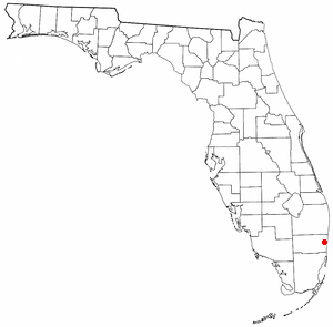
Hamptons at Boca Raton was a former census-designated place (CDP) and current unincorporated place near Boca Raton in Palm Beach County, Florida, United States. The population was 11,306 at the 2000 census. While it is not officially in the City of Boca Raton, the community is frequently classified under its umbrella term.

Lake Belvedere Estates is a census-designated place (CDP) in Palm Beach County, Florida, United States. It is part of the Miami metropolitan area of South Florida. The population was 2,091 at the 2020 US census.

<span class="mw-page-title-main">Mission Bay, Florida</span> Unincorporated place in Florida, United States

Mission Bay was a census-designated place (CDP) and current unincorporated place west of Boca Raton in Palm Beach County, Florida, United States. The population was 3,066 at the 2000 census.

Plantation Mobile Home Park is a census-designated place (CDP) in Palm Beach County, Florida, United States. It is part of the Miami metropolitan area of South Florida. The population was 1,462 at the 2020 US census.

<span class="mw-page-title-main">Ridgecrest, Florida</span> Census-designated place in Florida, United States

Ridgecrest is a census-designated place (CDP) in Pinellas County, Florida, United States. The population was 2,558 at the 2010 census.

<span class="mw-page-title-main">Glencoe, Florida</span> CDP in Florida, United States

Glencoe is a census-designated place (CDP) in Volusia County, Florida, United States. The population was 2,582 at the 2010 census.

<span class="mw-page-title-main">Crystal Lake, Polk County, Florida</span> Census-designated place in Florida, United States

Crystal Lake is a census-designated place (CDP) in Polk County, Florida, United States. The population was 5,341 at the 2000 census, an increase from 5,300 in 1990. The 2010 Census reported a population of 5,514. It is part of the Lakeland–Winter Haven Metropolitan Statistical Area.

<span class="mw-page-title-main">Fernway, Pennsylvania</span> Former census-designated place in Pennsylvania, United States

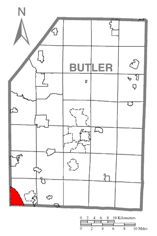
Fernway is a neighborhood in Cranberry Township, Butler County, Pennsylvania, United States. It includes 458 homes on 183 acres and was the first planned housing subdivision in the Township, dating back to the 1950s. Fernway was formerly used as the name of a census-designated place (CDP), but the designation was removed as of TIGER 2013 after Cranberry Township officials pointed out that users of Internet mapping websites frequently misinterpreted the CDP as the name of its parent municipality.

<span class="mw-page-title-main">Hooverson Heights, West Virginia</span> Census-designated place in West Virginia, United States

Hooverson Heights is a census-designated place (CDP) in Brooke County, West Virginia, United States. It is part of the Weirton–Steubenville metropolitan area. The population was 2,590 at the 2010 census.

Cassville is a census-designated place (CDP) in Monongalia County, West Virginia, United States. The population was 1,268 at the 2020 census. It is included in the Morgantown, West Virginia Metropolitan Statistical Area. Cassville was named after Lewis Cass, a prominent American statesman who served as Secretary of War, Secretary of State, and Governor of Michigan.

<span class="mw-page-title-main">Rib Mountain (CDP), Wisconsin</span> CDP in Wisconsin, United States

Rib Mountain is a census-designated place (CDP) in the town of Rib Mountain in Marathon County, Wisconsin, United States. The population was 6,061 at the 2020 census.

References

  1. "US Board on Geographic Names". United States Geological Survey. 2007-10-25. Retrieved 2008-01-31.
  2. "US Gazetteer files: 2010, 2000, and 1990". United States Census Bureau. 2011-02-12. Retrieved 2011-04-23.
  3. "CENSUS OF POPULATION AND HOUSING (1790-2000)". U.S. Census Bureau . Retrieved 2010-07-30.
  4. "U.S. Census website". United States Census Bureau . Retrieved 2008-01-31.
  5. "MLA Data Center Results for High Point, Florida". Modern Language Association . Retrieved 2007-12-13.