Villages of Oriole, Florida

Last updated
Villages of Oriole, Florida
FLMap-doton-VillagesOfOriole.PNG
Location of Villages of Oriole, Florida
Coordinates: 26°27′33″N80°9′20″W / 26.45917°N 80.15556°W / 26.45917; -80.15556 Coordinates: 26°27′33″N80°9′20″W / 26.45917°N 80.15556°W / 26.45917; -80.15556
Country Flag of the United States.svg  United States
State Flag of Florida.svg  Florida
County   Palm Beach
Area
  Total1.0 sq mi (2.7 km2)
  Land1.0 sq mi (2.7 km2)
  Water0.0 sq mi (0.0 km2)
Elevation
20 ft (6 m)
Population
 (2000)
  Total4,758
  Density4,637.5/sq mi (1,790.5/km2)
Time zone UTC-5 (Eastern (EST))
  Summer (DST) UTC-4 (EDT)
FIPS code 12-74494 [1]
GNIS feature ID1867222 [2]

Villages of Oriole was a census-designated place (CDP) in Palm Beach County, Florida, United States. The population was 4,758 at the 2000 census.

Contents

Geography

Villages of Oriole is located at 26°27′33″N80°9′20″W / 26.45917°N 80.15556°W / 26.45917; -80.15556 (26.459218, -80.155569). [3]

According to the United States Census Bureau, the CDP has a total area of 2.7 km2 (1.0 mi2), all land.

Demographics

At the 2000 census, [1] there were 4,758 people, 3,072 households and 1,517 families residing in the CDP. The population density was 1,783.6/km2 (4,637.5/mi2). There were 3,750 housing units at an average density of 1,405.7/km2 (3,655.0/mi2). The racial makeup of the CDP was 99.33% White (98.8% were Non-Hispanic White,) [4] 0.29% African American, 0.04% Asian, 0.04% Pacific Islander, 0.11% from other races, and 0.19% from two or more races. Hispanic or Latino of any race were 0.63% of the population.

There were 3,072 households, of which 0.2% had children under the age of 18 living with them, 47.1% were married couples living together, 1.7% had a female householder with no husband present, and 50.6% were non-families. 47.7% of all households were made up of individuals, and 45.0% had someone living alone who was 65 years of age or older. The average household size was 1.55 and the average family size was 2.04.

0.4% of the population were under the age of 18, 0.2% from 18 to 24, 1.5% from 25 to 44, 6.3% from 45 to 64, and 91.7% who were 65 years of age or older. The median age was 77 years. For every 100 females, there were 68.1 males. For every 100 females age 18 and over, there were 68.1 males.

The median household income was $30,719 and the median family income was $40,884. Males had a median income of $21,083 compared with $24,297 for females. The per capita income for the CDP was $24,496. About 3.8% of families and 7.0% of the population were below the poverty line, including none of those under age 18 and 6.4% of those age 65 or over.

English was the first language for 92.70% of all residents, while Yiddish accounted for 5.90%, Italian made up 0.75%, and Hungarian was the mother tongue for 0.64% of the population. [5]

Related Research Articles

Cahaba Heights, Vestavia Hills Neighborhood in Jefferson, Alabama, United States

Cahaba Heights is a neighborhood of Vestavia Hills, a city in Jefferson County, Alabama, United States. Before annexation in 2002, it was a census-designated place (CDP) in 1990 and 2000; the population was 5,203 at the 2000 census.

Central Heights-Midland City, Arizona Census-designated place in Arizona, United States

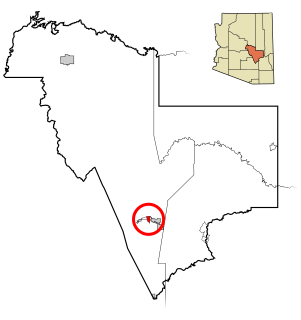
Central Heights-Midland City is an unincorporated community and census-designated place (CDP) in Gila County, Arizona, United States. The population was 2,534 at the 2010 census.

Mayflower Village, California census-designated place in California, United States

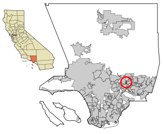
Mayflower Village is a census-designated place (CDP) in the San Gabriel Valley, in Los Angeles County, California, United States. The population was 5,515 at the 2010 census, up from 5,081 at the 2000 census. The ZIP Codes serving the community are 91006, which is served by Arcadia and 91016, which is served by Monrovia.

Roxborough Park, Colorado Census-designated place in State of Colorado, United States

Roxborough Park is Subdivision within Roxborough, Colorado. Roxborough, Colorado is a census-designated place (CDP) in Douglas County, Colorado, United States. The population was 9,099 at the 2010 census, up from 4,446 at the 2000 census.

Wabasso Beach, Florida CDP in Florida, United States

Wabasso Beach is a census-designated place (CDP) in Indian River County, Florida, United States. The population was 1,853 at the 2010 census, an increase of 72.4% since 2000. It is part of the Sebastian–Vero Beach Metropolitan Statistical Area.

The Crossings, Florida CDP in Florida, United States

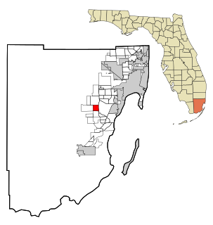
The Crossings is a census-designated place (CDP) Miami suburb in Miami-Dade County, Florida, United States. The population was 22,758 at the 2010 census. In addition to The Crossings, the CDP also includes the West Kendall communities of Devon Aire and Calusa. The CDP is bordered on the north by Kendall Drive, on the south by SW 120th Street, by Florida's Turnpike on the east, and SW 137th Avenue on the west.

Fremd Village-Padgett Island was a census-designated place (CDP) in Palm Beach County, Florida, United States. The population was 2,264 at the 2000 census.

Kings Point, Florida unincorporated place in Florida, United States

Kings Point is a census-designated place (CDP) in Palm Beach County, Florida, United States. The population was 12,207 at the 2000 census.

Southgate, Florida Census-designated place in Florida, United States

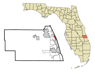
Southgate is a census-designated place (CDP) in Sarasota County, Florida, United States. The population was 7,173 at the 2010 census. It is part of the Bradenton–Sarasota–Venice Metropolitan Statistical Area.

Fallston, Maryland Census-designated place in Maryland, United States

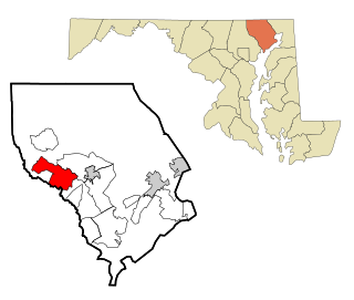
Fallston is a census-designated place (CDP) in Harford County, Maryland, United States. The population was 8,958 at the 2010 census, up from 8,427 in 2000. Fallston is a semi-rural community consisting mostly of farms and suburban-like developments.

Forestdale, Massachusetts Census-designated place in Massachusetts, United States

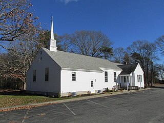
Forestdale is a village and census-designated place (CDP) within the town of Sandwich in Barnstable County, Massachusetts, United States. The population of Forestdale was 4,099 at the 2010 census. It is the most populous of the three CDPs in Sandwich. The ZIP code of Forestdale is 02644.

Millers Falls, Massachusetts Census-designated place in Massachusetts, United States

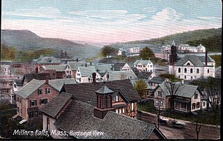
Millers Falls is a census-designated place (CDP) in the town of Montague in Franklin County, Massachusetts, United States. The population was 1,139 at the 2010 census. It is part of the Springfield, Massachusetts metropolitan statistical area.

Pemberton Heights, New Jersey Census-designated place in New Jersey, United States

Pemberton Heights is an unincorporated community and census-designated place (CDP) located within Pemberton Township, in Burlington County, New Jersey, United States. As of the 2010 United States Census, the CDP's population was 2,423.

East Ithaca, New York CDP in New York, United States

East Ithaca is a suburban community in Tompkins County, New York, United States. The population was 2,231 at the 2010 census.

Lucerne Mines, Pennsylvania Census-designated place in Pennsylvania, United States

Lucernemines, usually written as Lucerne Mines, is a census-designated place (CDP) in Indiana County, Pennsylvania, United States. The population was 937 at the 2010 census.

Milroy, Pennsylvania CDP in Pennsylvania, United States

Milroy is a census-designated place (CDP) in the Kishacoquillas Valley of Mifflin County, Pennsylvania, United States. The population was 1,386 at the 2000 census.

Maple Glen, Pennsylvania Census-designated place in Pennsylvania, United States

Maple Glen is a census-designated place (CDP) in Montgomery County, Pennsylvania, United States. The population was 6,742 at the 2010 census.

Lancaster Mill, South Carolina CDP in South Carolina, United States

Lancaster Mill is a census-designated place (CDP) in Lancaster County, South Carolina, United States. The population was 2,109 at the 2000 census.

Sugar Grove, Virginia CDP in Virginia, United States

Sugar Grove is a census-designated place (CDP) in Smyth County, Virginia, United States. The population was 758 at the 2010 census.

Fort Fairfield (CDP), Maine Census-designated place in Maine, United States

Fort Fairfield is a census-designated place (CDP) comprising the main village within the town of Fort Fairfield in Aroostook County, Maine, United States. The population of the CDP was 1,825 at the 2010 census, out of a population of 3,496 for the entire town.

References

  1. 1 2 "U.S. Census website". United States Census Bureau . Retrieved 2008-01-31.
  2. "US Board on Geographic Names". United States Geological Survey. 2007-10-25. Retrieved 2008-01-31.
  3. "US Gazetteer files: 2010, 2000, and 1990". United States Census Bureau. 2011-02-12. Retrieved 2011-04-23.
  4. "Demographics of Villages of Oriole, FL". MuniNetGuide.com. Retrieved 2007-12-14.
  5. "MLA Data Center Results for Villages of Oriole, Florida". Modern Language Association . Retrieved December 14, 2007.