Royal Palm Estates, Florida

Last updated

Royal Palm Estates, Florida
CDP
Coordinates: 26°40′51″N80°7′38″W / 26.68083°N 80.12722°W / 26.68083; -80.12722
Country Flag of the United States.svg  United States
State Flag of Florida.svg  Florida
County   Palm Beach
Area
[1]
  Total0.25 sq mi (0.65 km2)
  Land0.25 sq mi (0.65 km2)
  Water0.00 sq mi (0.00 km2)
Elevation
16 ft (5 m)
Population
 (2020)
  Total1,974
  Density7,864.54/sq mi (3,038.24/km2)
Time zone UTC-5 (Eastern (EST))
  Summer (DST) UTC-4 (EDT)
ZIP code
33413 [2]
Area code 561
FIPS code 12-62118 [3]
GNIS feature ID1853283 [4]

Royal Palm Estates is a census-designated place (CDP) in Palm Beach County, Florida, United States. The population was 1,974 at the 2020 census.

Contents

Geography

Royal Palm Estates is located at 26°40′51″N80°7′38″W / 26.68083°N 80.12722°W / 26.68083; -80.12722 (26.680793, -80.127214). [5]

According to the United States Census Bureau, the CDP has a total area of 2.1 km2 (0.8 mi2), all land.

Demographics

Historical population
CensusPop.Note
2020 1,974
U.S. Decennial Census [6]

As of the census [3] of 2000, there were 3,583 people, 1,126 households, and 835 families residing in the CDP. The population density was 1,729.3/km2 (4,451.1/mi2). There were 1,204 housing units at an average density of 581.1/km2 (1,495.7/mi2). The racial makeup of the CDP was 69.83% White (47.2% were Non-Hispanic White,) [7] 15.27% African American, 0.45% Native American, 1.28% Asian, 0.11% Pacific Islander, 8.54% from other races, and 4.52% from two or more races. Hispanic or Latino of any race were 34.08% of the population.

There were 1,126 households, out of which 44.8% had children under the age of 18 living with them, 44.6% were married couples living together, 19.4% had a female householder with no husband present, and 25.8% were non-families. 17.4% of all households were made up of individuals, and 3.0% had someone living alone who was 65 years of age or older. The average household size was 3.10 and the average family size was 3.41.

In the CDP, the population was spread out, with 30.3% under the age of 18, 10.4% from 18 to 24, 34.7% from 25 to 44, 17.5% from 45 to 64, and 7.1% who were 65 years of age or older. The median age was 30 years. For every 100 females, there were 106.4 males. For every 100 females age 18 and over, there were 103.8 males.

The median income for a household in the CDP was $31,331, and the median income for a family was $32,402. Males had a median income of $26,563 versus $21,587 for females. The per capita income for the CDP was $18,231. About 18.4% of families and 22.2% of the population were below the poverty line, including 23.3% of those under age 18 and 7.4% of those age 65 or over.

As of 2000, English was the first language for 65.12% of all residents, while Spanish made up 33.76%, and French Creole was the mother tongue for 1.12% of the population. [8]

Related Research Articles

<span class="mw-page-title-main">Cocoa West, Florida</span> CDP in Florida, United States

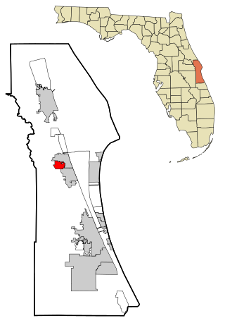
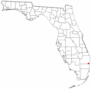
Cocoa West is a census-designated place (CDP) in Brevard County, Florida, United States. The population was 5,925 at the 2010 census. It is the closest place to Lake Poinsett and Canaveral Groves.

Palm Aire, Florida was an unincorporated census-designated place in Broward County, Florida consisting of residential property, commercial businesses, and four golf courses. Palm Aire describes both Palm Aire Village, a collection of single-family houses, and Palm Aire Country Club, a 5,000-acre (20 km2) property with condominiums, villas, estate homes, and four golf courses. It is now part of the cities of Fort Lauderdale and Pompano Beach.

Royal Palm Ranches is a former census-designated place (CDP) in Broward County, Florida, United States. The population was 294 at the 2000 census. It now serves as a community of Cooper City, Florida.

<span class="mw-page-title-main">Palm Springs North, Florida</span> Census-designated place in Florida, United States

Palm Springs North is an unincorporated community and census-designated place (CDP) in Miami-Dade County, Florida, United States. The population was 5,030 at the 2020 census.

<span class="mw-page-title-main">Palmetto Estates, Florida</span> Census-designated place in Florida, United States

Palmetto Estates is an unincorporated area and census-designated place (CDP) in Miami-Dade County, Florida, United States. The population was 13,498 at the 2020 census.

<span class="mw-page-title-main">Westwood Lakes, Florida</span> Census-designated place in Florida, United States

Westwood Lakes is a census-designated place and unincorporated part of Miami-Dade County, Florida, United States. The population was 11,373 at the 2020 census.

<span class="mw-page-title-main">Belle Glade Camp, Florida</span> Unincorporated place in Florida, United States

Belle Glade Camp was a census-designated place (CDP) in Palm Beach County, Florida, United States. The population was 1,141 at the 2000 census.

Dunes Road is a former census-designated place (CDP) in Palm Beach County, Florida, United States. The population was 391 at the 2000 census.

Fremd Village-Padgett Island was a census-designated place (CDP) in Palm Beach County, Florida, United States. The population was 2,264 at the 2000 census.

Gun Club Estates is a census-designated place (CDP) in Palm Beach County, Florida, United States. The population was 816 at the 2020 census. The CDP is located in an unincorporated area near the southwest corner of the Palm Beach International Airport (PBI) and is bounded by West Palm Beach Canal on the north, Kirk Road on the east, Gun Club Road on the south, and Military Trail on the west.

High Point was a census-designated place (CDP) in Palm Beach County, Florida, United States. The population was 2,191 at the 2000 census. The CDP was removed from the 2010 census. Although it is still unincorporated, it is within Delray Beach's "future annexation area."

Juno Ridge is a census-designated place (CDP) in Palm Beach County, Florida, United States. The population was 742 at the 2000 census.

Lake Belvedere Estates is a census-designated place (CDP) in Palm Beach County, Florida, United States. The population was 2,091 at the 2020 census.

<span class="mw-page-title-main">Lake Harbor, Florida</span> CDP in Florida, United States

Lake Harbor is a census-designated place (CDP) in Palm Beach County, Florida, United States. The population was 49 at the 2020 census. It located along the southern banks of Lake Okeechobee, at the beginning of the Miami Canal. John Stretch Park is also located alongside the north end of Lake Harbor and the lake.

<span class="mw-page-title-main">Lakeside Green, Florida</span> Unincorporated place in Florida, United States

Lakeside Green was a census-designated place (CDP) in Palm Beach County, Florida, United States. The population was 3,311 at the 2000 census.

Limestone Creek is a census-designated place (CDP) in Palm Beach County, Florida, United States. The population was 1,316 at the 2020 census.

<span class="mw-page-title-main">Sandalfoot Cove, Florida</span> Unincorporated place in Florida, United States

Sandalfoot Cove was a census-designated place (CDP) located in an unincorporated area near Boca Raton in Palm Beach County, Florida, United States. The population was 16,582 at the 2000 census. While it is not officially in the City of Boca Raton, the community is frequently classified under its umbrella term.

Schall Circle is a census-designated place (CDP) in Palm Beach County, Florida, United States. The population was 792 at the 2020 census.

<span class="mw-page-title-main">Villages of Oriole, Florida</span> Unincorporated place in Florida, United States

Villages of Oriole was a census-designated place (CDP) in Palm Beach County, Florida, United States. The population was 4,758 at the 2000 census.

<span class="mw-page-title-main">Brookmont, Maryland</span> Census-designated place in Maryland, United States

Brookmont is a census-designated place and unincorporated area in Montgomery County, Maryland, United States. As of the 2020 census, it had a population of 3,751. Brookmont is often considered part of neighboring Bethesda because it falls within Bethesda's 20816 zip code.

References

  1. "2020 U.S. Gazetteer Files". United States Census Bureau. Retrieved October 31, 2021.
  2. "Royal Palm Estates FL ZIP Code". zipdatamaps.com. 2023. Retrieved February 17, 2023.
  3. 1 2 "U.S. Census website". United States Census Bureau . Retrieved January 31, 2008.
  4. "US Board on Geographic Names". United States Geological Survey. October 25, 2007. Retrieved January 31, 2008.
  5. "US Gazetteer files: 2010, 2000, and 1990". United States Census Bureau. February 12, 2011. Retrieved April 23, 2011.
  6. "Census of Population and Housing". Census.gov. Retrieved June 4, 2016.
  7. "Demographics of Royal Palm Estates, FL". MuniNetGuide.com. Retrieved December 14, 2007.
  8. "MLA Data Center Results for Royal Palm Estates, Florida". Modern Language Association . Retrieved December 14, 2007.