Plantation Mobile Home Park, Florida

Last updated

Plantation Mobile Home Park, Florida
CDP
Coordinates: 26°42′9″N80°7′57″W / 26.70250°N 80.13250°W / 26.70250; -80.13250
Country Flag of the United States.svg  United States
State Flag of Florida.svg  Florida
County Flag of Palm Beach County, Florida.png Palm Beach
Area
[1]
  Total0.26 sq mi (0.68 km2)
  Land0.26 sq mi (0.67 km2)
  Water0.00 sq mi (0.01 km2)
Elevation
16 ft (5 m)
Population
 (2020)
  Total1,462
  Density5,623.08/sq mi (2,170.99/km2)
Time zone UTC-5 (Eastern (EST))
  Summer (DST) UTC-4 (EDT)
ZIP code
33417 [2]
Area code 561
FIPS code 12-57518 [3]
GNIS feature ID1853278 [4]

Plantation Mobile Home Park is a census-designated place (CDP) in Palm Beach County, Florida, United States. It is part of the Miami metropolitan area of South Florida. The population was 1,462 at the 2020 US census.

Contents

Geography

Plantation Mobile Home Park is located at 26°42′9″N80°7′57″W / 26.70250°N 80.13250°W / 26.70250; -80.13250 (26.702392, -80.132515). [5]

According to the United States Census Bureau, the CDP has a total area of 0.7 km2 (0.3 mi2), of which 0.7 km2 (0.3 mi2) is land and 3.85% is water.

Demographics

Historical population
CensusPop.Note
2000 1,218
2010 1,2603.4%
2020 1,46216.0%
U.S. Decennial Census [6]

2020 census

Plantation Mobile Home Park racial composition
(Hispanics excluded from racial categories)
(NH = Non-Hispanic) [7]
RaceNumberPercentage
White (NH)45931.40%
Black or African American (NH)18912.93%
Native American or Alaska Native (NH)20.14%
Asian (NH)100.68%
Pacific Islander or Native Hawaiian (NH)00.00%
Some Other Race (NH)90.62%
Mixed/Multiracial (NH)412.80%
Hispanic or Latino 75251.44%
Total1,462

As of the 2020 United States census, there were 1,462 people, 529 households, and 370 families residing in the CDP. [8]

2010 census

Plantation Mobile Home Park racial composition
(Hispanics excluded from racial categories)
(NH = Non-Hispanic) [9]
RaceNumberPercentage
White (NH)56444.76%
Black or African American (NH)16012.70%
Native American or Alaska Native (NH)50.40%
Asian (NH)151.19%
Pacific Islander or Native Hawaiian (NH)10.08%
Some Other Race (NH)30.24%
Mixed/Multiracial (NH)211.67%
Hispanic or Latino 49138.97%
Total1,260

As of the 2010 United States census, there were 1,260 people, 450 households, and 233 families residing in the CDP. [10]

2000 census

As of the census [3] of 2000, there were 1,218 people, 490 households, and 293 families residing in the CDP. The population density was 1,808.7/km2 (4,734.5/mi2). There were 531 housing units at an average density of 788.5/km2 (2,064.0/mi2). The racial makeup of the CDP was 73.65% White (66.3% were Non-Hispanic White), [11] 13.14% African American, 0.25% Native American, 0.41% Asian, 0.16% Pacific Islander, 6.65% from other races, and 5.75% from two or more races. Hispanic or Latino of any race were 17.41% of the population.

In 2000, there were 490 households, out of which 32.0% had children under the age of 18 living with them, 33.3% were married couples living together, 20.0% had a female householder with no husband present, and 40.2% were non-families. 29.8% of all households were made up of individuals, and 8.6% had someone living alone who was 65 years of age or older. The average household size was 2.49 and the average family size was 3.07.

As of 2000, in the CDP, the population was spread out, with 27.8% under the age of 18, 8.9% from 18 to 24, 33.8% from 25 to 44, 19.4% from 45 to 64, and 10.2% who were 65 years of age or older. The median age was 34 years. For every 100 females, there were 100.3 males. For every 100 females age 18 and over, there were 97.3 males.

In 2000, the median income for a household in the CDP was $32,734, and the median income for a family was $32,963. Males had a median income of $30,856 versus $20,724 for females. The per capita income for the CDP was $13,325. About 17.5% of families and 20.8% of the population were below the poverty line, including 36.7% of those under age 18 and 11.2% of those age 65 or over.

As of 2000, English was the first language for 86.88% of all residents, while Spanish was the mother tongue for 13.11% of the population. [12]

Related Research Articles

Boulevard Gardens is a census-designated place (CDP) in Broward County, Florida, United States. The population was 1,457 at the 2020 census.

Hillsboro Pines is a census-designated place (CDP) in Broward County, Florida, United States. The population was 496 at the 2020 census.

Roosevelt Gardens is a census-designated place (CDP) in Broward County, Florida, United States. The population was 2,749 at the 2020 census.

<span class="mw-page-title-main">Olga, Florida</span> Census-designated place in Florida, United States

Olga is an unincorporated community and census-designated place (CDP) in Lee County, Florida, United States. The population was 1,952 at the 2010 census, up from 1,398 at the 2000 census. It is part of the Cape Coral-Fort Myers, Florida Metropolitan Statistical Area.

<span class="mw-page-title-main">Tavernier, Florida</span> Census-designated place in Florida, United States

Tavernier is a census-designated place (CDP) and unincorporated community in Monroe County, Florida, United States on Key Largo, the largest island in the upper Florida Keys. Tavernier's population was 2,530 at the 2020 census, up from 2,136 in 2010.

Gun Club Estates is a census-designated place (CDP) in Palm Beach County, Florida, United States. It is part of the Miami metropolitan area of South Florida. The population was 816 at the 2020 US census.

Juno Ridge is a census-designated place (CDP) in Palm Beach County, Florida, United States. It is part of the Miami metropolitan area of South Florida. The population was 1,186 at the 2020 US census.

Lake Belvedere Estates is a census-designated place (CDP) in Palm Beach County, Florida, United States. It is part of the Miami metropolitan area of South Florida. The population was 2,091 at the 2020 US census.

Limestone Creek is a census-designated place (CDP) in Palm Beach County, Florida, United States. It is part of the Miami metropolitan area of South Florida. The population was 1,316 at the 2020 US census.

Stacy Street is a street and surrounding census-designated place (CDP) in Palm Beach County, Florida, United States. The population was 978 at the 2020 census, which misspelled it as Stacey Street.

<span class="mw-page-title-main">Experiment, Georgia</span> CDP in Georgia, United States

Experiment is a census-designated place (CDP) in Spalding County, Georgia, United States. The population was 3,233 at the 2000 census.

<span class="mw-page-title-main">Glasgow Village, Missouri</span> CDP in Missouri, United States

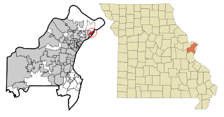
Glasgow Village is a census-designated place (CDP) in St. Louis County, Missouri, United States. The population was 5,429 at the 2010 census.

<span class="mw-page-title-main">Castle Point, Missouri</span> CDP in Missouri, United States

Castle Point is a census-designated place (CDP) in St. Louis County, Missouri, United States. The population was 3,962 at the 2010 census.

<span class="mw-page-title-main">Ashland Heights, South Dakota</span> CDP in South Dakota, United States

Ashland Heights is a census-designated place (CDP) and unincorporated community in Pennington County, South Dakota, United States. The population was 678 at the 2020 census.

<span class="mw-page-title-main">Cameron Park, Texas</span> CDP in Texas, United States

Cameron Park is a census-designated place (CDP) in Cameron County, Texas, United States. The population was 6,963 at the 2010 census. It is part of the Brownsville–Harlingen Metropolitan Statistical Area.

<span class="mw-page-title-main">Redwood, Texas</span> Unincorporated community in Texas, United States

Redwood is an unincorporated community and census-designated place (CDP) in Guadalupe County, Texas, United States. The population was 4,003 at the 2020 census, down from 4,338 at the 2010 census. It is part of the San Antonio Metropolitan Statistical Area.

<span class="mw-page-title-main">Pecan Plantation, Texas</span> Census-designated place in Texas, United States

Pecan Plantation is an unincorporated community and census-designated place (CDP) in southeast Hood County, Texas, United States. Its population was 5,294 at the 2010 census, up from 3,544 at the 2000 census. It is part of the Granbury, Texas, micropolitan statistical area.

<span class="mw-page-title-main">Eidson Road, Texas</span> CDP in Texas, United States

Eidson Road is a census-designated place (CDP) in Maverick County, Texas, United States. The population was 8,960 at the 2010 census.

<span class="mw-page-title-main">El Indio, Texas</span> CDP in Texas, United States

El Indio is a census-designated place (CDP) in Maverick County, Texas, United States. The population was 263 at the 2000 census.

<span class="mw-page-title-main">San Isidro, Texas</span> CDP in Texas, United States

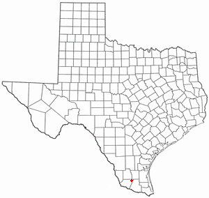
San Isidro is a census-designated place (CDP) in Starr County, Texas, United States. The population was 240 at the 2010 census. The town is named for St. Isidore the Laborer, the patron saint of farmers. A large Southwestern Barrel Cactus growing just east of town is said to be the largest in Texas.

References

  1. "2020 U.S. Gazetteer Files". United States Census Bureau. Retrieved October 31, 2021.
  2. "Plantation Mobile Home Park FL ZIP Code". zipdatamaps.com. 2023. Retrieved February 17, 2023.
  3. 1 2 "U.S. Census website". United States Census Bureau . Retrieved January 31, 2008.
  4. "US Board on Geographic Names". United States Geological Survey. October 25, 2007. Retrieved January 31, 2008.
  5. "US Gazetteer files: 2010, 2000, and 1990". United States Census Bureau. February 12, 2011. Retrieved April 23, 2011.
  6. "Census of Population and Housing". Census.gov. Retrieved June 4, 2016.
  7. "HISPANIC OR LATINO, AND NOT HISPANIC OR LATINO BY RACE: 2020". data.census.gov. Retrieved July 26, 2023.
  8. "HOUSEHOLDS AND FAMILIES: 2020". data.census.gov. Retrieved July 26, 2023.
  9. "HISPANIC OR LATINO, AND NOT HISPANIC OR LATINO BY RACE: 2010". data.census.gov. Retrieved July 26, 2023.
  10. "HOUSEHOLDS AND FAMILIES: 2010". data.census.gov. Retrieved July 26, 2023.
  11. "Demographics of Plantation Mobile Home Park, FL". MuniNetGuide.com. Retrieved December 14, 2007.
  12. "MLA Data Center Results for Plantation Mobile Home Park, Florida". Modern Language Association . Retrieved December 14, 2007.