The Little Maquoketa River Mounds State Preserve is an Iowa state owned archaeological site and natural area located within the city of Sageville, just north of Dubuque, on U.S. Highway 52.
It is high up on a limestone ridge above the Little Maquoketa River,[1] not too far from the river's mouth with the Upper Mississippi River. Covering about 42 acres (170,000m2), it contains a fenced-in 3-acre (12,000m2) burial area with 32 mounds.[1] The graves have been related to the Late Woodland culture, about AD 700-1200. Significant consultation went on with Native American tribes regarding the establishment of the preserve.
The land was purchased by the Iowa Department of Transportation in 1977, and in 1981, it became a state archaeological and geological preserve. By agreement with the state, the Dubuque County Conservation Board maintains and administers the area.
The remainder of the preserve functions as a park with a hiking trail, featuring mature forest and a segment of native blufftop prairie.[1] As a part of the Driftless Area of Iowa, it has some geologically interesting areas, particularly the high limestone bluffs.
Jackson County is a county located in the U.S. state of Iowa. As of the 2020 census, the population was 19,485. The county seat is Maquoketa.
Dubuque County is a county located in the U.S. state of Iowa. As of the 2020 census, the population was 99,266, making it the eighth-most populous county in Iowa. The county seat is Dubuque. The county is named for Julien Dubuque, the first European settler of Iowa.
The Maquoketa River is a tributary of the Mississippi River, approximately 150 miles (240 km) long, in northeastern Iowa in the United States. Its watershed covers 1,694 square miles (4,387 km2) within a rural region of rolling hills and farmland southwest of Dubuque. It is not to be confused with the Little Maquoketa River, another distinct direct tributary of the Upper Mississippi River meeting the Big River north of Dubuque. The river and its tributaries mark the border of the Driftless Area of Iowa, with the areas east of it not having been covered by ice during the last ice age. Its name derives from Maquaw-Autaw, which means "Bear River" in Meskwaki.
Maquoketa Caves State Park is a state park of Iowa, United States, located in Jackson County. It stands northwest of the city of Maquoketa. In 1991 111 acres (45 ha) on the east side of the park were listed as a historic district on the National Register of Historic Places.
The Driftless Area, a topographical and cultural region in the American Midwest, comprises southwestern Wisconsin, southeastern Minnesota, northeastern Iowa, and the extreme northwestern corner of Illinois.
The Loess Hills are a formation of wind-deposited loess soil in the westernmost parts of Iowa and Missouri, and the easternmost parts of Nebraska and Kansas, along the Missouri River.
Stone State Park is a state park of Iowa, USA, located in the bluffs and ravines adjacent to the Big Sioux River. The park consists of 1,069 acres (433 ha) in Woodbury and Plymouth Counties near Sioux City, and overlooks the South Dakota-Iowa border. Stone Park is near the northernmost extent of the Loess Hills, and is at the transition from clay bluffs and prairie to sedimentary rock hills and bur oak forest along the Iowa side of the Big Sioux River. A variety of prairie plants can be found on the steep slopes and ridges, including yucca, penstemon, rough blazing star, silky aster, and pasque flower. Wild turkey, white-tailed deer, coyote, and red fox are found in the park. Birdlife includes the turkey vulture, barred owl, rufous-sided (eastern) towhee, and the ovenbird. Exposed bedrock in the park is composed of lignite, shale, sandstone, and limestone, and dates to the Cretaceous period; it is rich in marine fossils. The park contains many miles of hiking and equestrian trails, and is a popular destination for day visitors, overnight campers, mountain bike enthusiasts, and picnickers.
Gitchie Manitou is a small nature preserve in Lyon County, in the extreme northwestern corner of Iowa just northwest of Granite, Iowa, or just southeast of Sioux Falls, South Dakota. This natural prairie preserve is noted for its ancient Native American burial mounds and precambrian Sioux Quartzite outcroppings, which are about 1.6 billion years old.
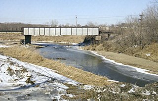
The Little Maquoketa River is a 29.6-mile-long (47.6 km) direct tributary of the upper Mississippi River. The Little Maquoketa River is largely confined to Dubuque County, Iowa, and enters the Mississippi in the rural areas north of Dubuque.
Yellow River State Forest, (YRSF), is mostly forested land owned by the Iowa Department of Natural Resources. It is located in the southeastern corner of Allamakee County, the most northeasterly of Iowa's counties. It is adjacent to the Upper Mississippi River National Wildlife and Fish Refuge and is just north of Effigy Mounds National Monument in the bluff region of the Upper Mississippi River.
Backbone State Park is Iowa's oldest state park, dedicated in 1919. Located in the valley of the Maquoketa River, it is approximately three miles (5 km) south of Strawberry Point in Delaware County. It is named for a narrow and steep ridge of bedrock carved by a loop of the Maquoketa River originally known as the Devil's Backbone. The initial 1,200 acres (490 ha) were donated by E.M. Carr of Lamont, Iowa. Backbone Lake Dam, a relatively low dam built by the Civilian Conservation Corps (CCC) in the 1930s, created Backbone Lake. The CCC constructed a majority of trails and buildings which make up the park.
Slinde Mounds State Preserve contains ancient Indian mound burials in some hill prairie. About 32 acres (130,000 m2) in extent, it is on a terrace above Canoe Creek, a tributary of the Upper Iowa River, and is approximately six miles from Waukon, Iowa in Hanover Township, in Allamakee County.
Fish Farm Mounds State Preserve is a 3-acre (12,000 m2) archaeological mound group containing Native American burials in the U.S. state of Iowa. It is located within the larger Fish Farms Mounds Wildlife area, a state owned hunting area a few miles south of New Albin, just inland from the Upper Mississippi River in Allamakee County.
Hartley Fort State Preserve is a 2-acre (8,100 m2) Iowa state preserve located on the Upper Iowa River in the Driftless Area, in Allamakee County of Iowa, USA.
The Mines of Spain State Recreation Area and E. B. Lyons Nature Center is a state park in Dubuque County, Iowa, United States. It is near Dubuque, the eleventh-largest city in the state. The park features picnic areas, 15 miles (24 km) of walking/hiking trails, 4 miles (6.4 km) of ski trails, and the Betty Hauptli Bird and Butterfly Garden. It also includes archaeological sites of national importance as an early lead mining and smelting venture led by French explorer Julien Dubuque, as well as Dubuque's gravesite. These sites were collectively designated a National Historic Landmark District as Julien Dubuque's Mines.
Woodman Hollow State Preserve is located in Webster County, Iowa, 7 miles (11 km) southeast of Fort Dodge and 6 miles (9.7 km) northwest of Lehigh. The preserve is a satellite area of Dolliver Memorial State Park, located 2 miles to the south. Some older maps refer to the area as "Woodman's Hollow State Park."
The following outline is provided as an overview of and topical guide to the U.S. state of Iowa.
Turkey River Mounds State Preserve is a historic site located near the unincorporated community of Millville, Iowa, United States. The 62-acre (25 ha) preserve contains thirty-eight of forty-three Native American mounds located on a narrow Paleozoic Plateau at the confluence of the Mississippi and Turkey rivers. They vary in size and shape and are 1.3 feet (0.40 m) to 6 feet (1.8 m) in height. The conical mounds range from 20 feet (6.1 m) to over 100 feet (30 m) in diameter. The linear mounds vary from 80 feet (24 m) to 175 feet (53 m) in length. There is one effigy mound in the shape of a panther that is 98 feet (30 m) long and 40 feet (12 m) wide. There are also compound mounds in the preserve. The mounds were constructed during the Woodland period. They were used for burials and ceremonial places, and are now protected by law. The preserve is also home to a variety of trees, prairie grasses and flowers.
Wapsipinicon State Park is located south of Anamosa, Iowa, United States. The 394-acre (159 ha) park is along the sandstone and limestone bluffs of the Wapsipinicon River, from which it derives its name. It is one of the oldest state parks in Iowa, and it was listed as a historic district on the National Register of Historic Places in 2014.
The Couler Valley is a valley near Dubuque, Iowa and has the Bee Branch Creek, previously the Couler Creek, located in it. It is about 5 miles (8.0 km) long. It is found in the Driftless Area.
This page is based on this Wikipedia article Text is available under the CC BY-SA 4.0 license; additional terms may apply. Images, videos and audio are available under their respective licenses.