Vernon Terrace, Brighton

Last updated

Vernon Terrace
Vernon Terrace (General View), Brighton.JPG
Vernon Terrace from the south-southeast
LocationVernon Terrace, Montpelier, Brighton, Brighton and Hove, East Sussex, United Kingdom
Coordinates 50°49′47″N0°08′59″W / 50.8296°N 0.1496°W / 50.8296; -0.1496
Built1856–57; c. 1860
Architectural style(s) Regency/Italianate
Listed Building – Grade II
Official name1–6 Vernon Terrace and attached railings;
7–16 Vernon Terrace and attached gate piers and balustrades;
37 Vernon Terrace and attached wall and piers
Designated20 August 1971; 26 August 1999
Location map Brighton central.png
Red pog.svg
Location of Vernon Terrace within central Brighton

Vernon Terrace is a mid 19th-century residential development in the Montpelier suburb of Brighton, part of the English coastal city of Brighton and Hove. Construction of the first section started in 1856, and the 37-house terrace was complete in the early 1860s. Architecturally, the houses divide into five separate compositions, [1] although all are in a similar late Regency/Italianate style. This was characteristic of houses of that era in Brighton, and especially in the Montpelier area—where the Regency style persisted much later than elsewhere. Standing opposite is the landmark Montpelier Crescent, which had a view of the South Downs until Vernon Terrace blocked it. Three groups of houses in the terrace have been listed at Grade II by English Heritage for their architectural and historical importance.

Contents

History

Brighton (originally known as Brighthelmston) [2] developed as a large fishing and agricultural village on the English Channel coast. Despite intermittent periods of decline and destitution, it was the largest town in the county of Sussex by 1600. In the mid-18th century, the damaging economic effects of a terminal decline in the fishing industry were reversed by the new fashion for sea-bathing, and the town's new role as a seaside resort began. [2] [3] Northwest of the old town, around the parish church and the road leading to Devil's Dyke and on to London, was an expanse of gently sloping downland known as Church Hill. It was given over to sheep-grazing and was owned by two prominent locals: MP Thomas Kemp and John Sackville, 3rd Duke of Dorset. [4] [5]

The flat-fronted numbers 1-6 are the oldest part of Vernon Terrace. 1-6 Vernon Terrace, Brighton (NHLE Code 1381070).JPG
The flat-fronted numbers 1–6 are the oldest part of Vernon Terrace.
The bow-fronted houses at 7-16 Vernon Terrace were finished in 1857. 7-16 Vernon Terrace, Brighton (NHLE Code 1381070).jpg
The bow-fronted houses at 7–16 Vernon Terrace were finished in 1857.

Helped by royal patronage (particularly from the Prince Regent) and good transport links to London and other important towns, [3] Brighton grew rapidly in the early 19th century, and high-class suburbs were laid out. The completion in 1841 of the main railway line from London provided a further stimulus. [6] By this time, Church Hill—ideally situated close to the sea and the town's main attractions, largely undeveloped and with a pleasant southwesterly aspect—was developing as a high-class residential area called Montpelier. [7] [8] Montpelier Road was laid out from 1820 as a major road running from the seafront to the Ditchling Road, [1] past the house built in 1819 for the late Thomas Kemp's son Thomas Read Kemp—who had become the main landowner in the area by inheriting his father's land. [9]

Just north of Kemp's house was a large nursery and market garden owned by Parsons and Sons, described at the time as "well-known florists on the Western Road". [10] The gardens were opposite Montpelier Crescent, a South Downs-facing development built between 1843 and 1847. [11] In 1856, a trade directory stated that 16 houses had been built on the west side [10] of the former Montpelier Road, which by that time had been renamed along most of its length: the stretch opposite Montpelier Crescent had been called Vernon Terrace. [1] Not all houses had residents at that stage, and four were in use as schools: numbers 7, 13, 15 and 16. [12] (Mid 19th-century Brighton was well known for its large number of educational establishments, especially boarding schools: it was sometimes nicknamed "School Town".) [13]

The terrace was added to in the early 1860s when more houses were built to the north [14] as far as the junction with Goldsmid Road, where a slightly older house (now numbered as 37 Vernon Terrace) already stood. This junction was remodelled in the late 19th century and became Seven Dials, a major roundabout where seven roads meet. [15] By 1876, when the area was mapped by the Ordnance Survey, almost all of the formerly agricultural land of Church Hill had been built upon; but some fields remained immediately behind Vernon Terrace. [16] This was filled in during the 1890s when the Edwardian-style red-brick houses of Vernon Gardens were built. [17]

Notable residents of Vernon Terrace have included Eleanor Marx, daughter of Karl Marx, who lived at number 6 during the 1870s. [18] By the early 21st century, all of the houses had become multiple-occupancy flats, but their modest front gardens survive. [14]

Heritage

37 Vernon Terrace stands next to Seven Dials. 37 Vernon Terrace, Brighton (NHLE Code 1381070).jpg
37 Vernon Terrace stands next to Seven Dials.

Three parts of Vernon Terrace have been listed at Grade II by English Heritage. This status is awarded to "nationally important" buildings of "special interest"; [19] as of February 2001 they made up three of 1,124 such buildings in the city. [20] Numbers 1–6 [21] and 7–16 [22] were listed on 20 August 1971; number 37, at the north end of the terrace, was listed on 26 August 1999. [23] Numbers 17 to 36 inclusive are not listed. [14]

Vernon Terrace forms part of the 75.4 acres (30.5 ha) Montpelier & Clifton Hill Conservation Area, one of 34 conservation areas in the city of Brighton and Hove. [24] This area was designated by the council in 1973. [25] Brighton & Hove City Council's report on the area's character states that Vernon Terrace is "an imposing terrace of houses" which together with Montpelier Crescent "form[s] a townscape of outstanding quality". [14] Vernon Terrace is immediately opposite the crescent; its construction meant that Montpelier Crescent's previously uninterrupted views of the South Downs were permanently blocked. [11]

Architecture

The houses at the south end of the terrace (1–6) date from between 1856 and 1857, and those at numbers 7–16 are contemporary. [11] Numbers 1, 6 and 7–16 rise to four storeys; the other houses have only three. All are stucco-clad and have cast iron balconies at first-floor level. [21] [22] The end house, number 1, has a two-window range and an entrance in Windlesham Avenue (with a three-storey canted bay window next to it. Numbers 2–6 each have three windows to each storey, but other differences include the detailing of the entrance porches: there are various combinations of single or double entablatures, pilasters, architraves and rustication, and the placement of the porches also varies. Continuous rustication spans all six ground-floor walls, though. Some windows are set in moulded architraves with pediments of various designs. A cornice runs above the top floor, but is not continuous and changes in style from flat to modillion. [21] At numbers 7–16, standard features include straight-headed entrance porches, ground-floor rustication, three windows to each storey, many set in architraves with decorative moulding, and a continuous cornice and parapet. Number 8 has extra balconies at second- and third-floor level. [22]

The unlisted houses at 17–36 have simple canted façades with sash windows. They date from the 1860s. [14] At the north end, 37 Vernon Terrace is an older house (dating from 1850 or earlier) [23] which was incorporated into the terrace. The main five-window façade is on Vernon Terrace, but there are two other elevations facing Seven Dials and Goldsmid Road; these have a canted bay window and architrave-framed windows respectively. [23] The centrally placed entrance is set in an elaborate doorcase with pilasters, an entablature and a Doric frieze with triglyphs. All windows contain original sashes, and those to the first floor are set in architraves. The two bays to the left of the entrance form a full-height bow. Included in the English Heritage listing are the garden walls with a continuous balustrade and square piers at intervals. [23]

Related Research Articles

<span class="mw-page-title-main">Royal Alexandra Children's Hospital</span> Hospital in England

The Royal Alexandra Children's Hospital is a children's hospital located within the grounds of the Royal Sussex County Hospital in Brighton on the south coast of England. It provides outpatient services, inpatient facilities, intensive care and a 24-hour emergency care service for children referred by GPs and other specialists. It is managed by the Brighton and Sussex University Hospitals NHS Trust.

<span class="mw-page-title-main">Grade II* listed buildings in Brighton and Hove</span>

There are 72 Grade II* listed buildings in the city of Brighton and Hove, England. The city, on the English Channel coast approximately 52 miles (84 km) south of London, was formed as a unitary authority in 1997 by the merger of the neighbouring towns of Brighton and Hove. Queen Elizabeth II granted city status in 2000.

<span class="mw-page-title-main">Grade II listed buildings in Brighton and Hove: A–B</span>

As of February 2001, there were 1,124 listed buildings with Grade II status in the English city of Brighton and Hove. The total at 2009 was similar. The city, on the English Channel coast approximately 52 miles (84 km) south of London, was formed as a unitary authority in 1997 by the merger of the neighbouring towns of Brighton and Hove. Queen Elizabeth II granted city status in 2000.

<span class="mw-page-title-main">Park Crescent, Brighton</span> Terrace of houses in Brighton, East Sussex, UK

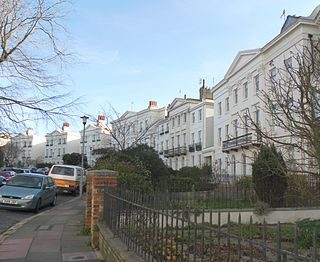
Park Crescent is a mid-19th-century residential development in the Round Hill area of Brighton, part of the English city of Brighton and Hove. The horseshoe-shaped, three-part terrace of 48 houses was designed and built by one of Brighton's most important architects, Amon Henry Wilds; by the time work started in 1849 he had 35 years' experience in the town. Wilds used the Italianate style rather than his more common Regency motifs. Three houses were replaced after the Second World War because of bomb damage, and another was the scene of one of Brighton's notorious "trunk murders" of the 1930s. The three parts of the terrace, which encircle a private garden formerly a pleasure ground and cricket pitch, have been listed at Grade II* by English Heritage for their architectural and historical importance.

<span class="mw-page-title-main">Grade II listed buildings in Brighton and Hove: C–D</span>

As of February 2001, there were 1,124 listed buildings with Grade II status in the English city of Brighton and Hove. The total at 2009 was similar. The city, on the English Channel coast approximately 52 miles (84 km) south of London, was formed as a unitary authority in 1997 by the merger of the neighbouring towns of Brighton and Hove. Queen Elizabeth II granted city status in 2000.

<span class="mw-page-title-main">Buildings and architecture of Brighton and Hove</span>

Brighton and Hove, a city on the English Channel coast in southeast England, has a large and diverse stock of buildings "unrivalled architecturally" among the country's seaside resorts. The urban area, designated a city in 2000, is made up of the formerly separate towns of Brighton and Hove, nearby villages such as Portslade, Patcham and Rottingdean, and 20th-century estates such as Moulsecoomb and Mile Oak. The conurbation was first united in 1997 as a unitary authority and has a population of about 253,000. About half of the 20,430-acre (8,270 ha) geographical area is classed as built up.

<span class="mw-page-title-main">Grade II listed buildings in Brighton and Hove: E–H</span>

As of February 2001, there were 1,124 listed buildings with Grade II status in the English city of Brighton and Hove. The total at 2009 was similar. The city, on the English Channel coast approximately 52 miles (84 km) south of London, was formed as a unitary authority in 1997 by the merger of the neighbouring towns of Brighton and Hove. Queen Elizabeth II granted city status in 2000.

Thomas Lainson, FRIBA was a British architect. He is best known for his work in the East Sussex coastal towns of Brighton and Hove, where several of his eclectic range of residential, commercial and religious buildings have been awarded listed status by English Heritage. Working alone or in partnership with two sons as Lainson & Sons, he designed buildings in a wide range of styles, from Neo-Byzantine to High Victorian Gothic; his work is described as having a "solid style, typical of the time".

<span class="mw-page-title-main">Round Hill, Brighton</span> Inner suburban area in Brighton, UK

Round Hill is an inner suburban area of Brighton, part of the coastal city of Brighton and Hove in England. The area contains a mix of privately owned and privately rented terraced housing, much of which has been converted for multiple occupancies, and small-scale commercial development. It was developed mostly in the late 19th century on an area of high land overlooking central Brighton and with good views in all directions, the area became a desirable middle-class suburb—particularly the large terraced houses of Roundhill Crescent and Richmond Road, and the exclusive Park Crescent—and within a few decades the whole of the hill had been built up with smaller terraces and some large villas.

<span class="mw-page-title-main">Roundhill Crescent</span> 19th-century housing development in Brighton and Hove

Roundhill Crescent is a late-19th-century housing development in Round Hill, an inner suburb of the English coastal city of Brighton and Hove. Partly developed in the 1860s with large terraced houses on a steeply sloping open hillside, the crescent—which "curves and changes height dramatically along its length"—was finished two decades later and now forms the centrepiece of the Round Hill conservation area. Smaller houses completed the composition in the 1880s, and England's first hospital for the treatment of mental illness was founded in the crescent in 1905. The five original sets of houses from the 1860s have been listed at Grade II by English Heritage for their architectural and historical importance, and the crescent occupies a prominent place on Brighton's skyline.

<span class="mw-page-title-main">Grade II listed buildings in Brighton and Hove: M</span>

As of February 2001, there were 1,124 listed buildings with Grade II status in the English city of Brighton and Hove. The total at 2009 was similar. The city, on the English Channel coast approximately 52 miles (84 km) south of London, was formed as a unitary authority in 1997 by the merger of the neighbouring towns of Brighton and Hove. Queen Elizabeth II granted city status in 2000.

<span class="mw-page-title-main">Montpelier, Brighton</span> Inner suburban area of Brighton, England

Montpelier is an inner suburban area of Brighton, part of the English city and seaside resort of Brighton and Hove. Developed together with the adjacent Clifton Hill area in the mid-19th century, it forms a high-class, architecturally cohesive residential district with "an exceptionally complete character". Stucco-clad terraced housing and villas predominate, but two of the city's most significant Victorian churches and a landmark hospital building are also in the area, which lies immediately northwest of Brighton city centre and spreads as far as the ancient parish boundary with Hove.

<span class="mw-page-title-main">Montpelier Crescent</span> Historic site in East Sussex, United Kingdom

Montpelier Crescent is a mid 19th-century crescent of 38 houses in the Montpelier suburb of Brighton, part of the English coastal city of Brighton and Hove. Built in five parts as a set-piece residential development in the rapidly growing seaside resort, the main part of the crescent was designed between 1843 and 1847 by prominent local architect Amon Henry Wilds and is one of his most distinctive compositions. Extra houses were added at both ends of the crescent in the mid-1850s. Unlike most other squares, terraces and crescents in Brighton, it does not face the sea—and the view it originally had towards the South Downs was blocked within a few years by a tall terrace of houses opposite. Montpelier was an exclusive and "salubrious" area of Brighton, and Montpelier Crescent has been called its "great showpiece". Wilds's central section has been protected as Grade II* listed, with the later additions listed separately at the lower Grade II. The crescent is in one of the city's 34 conservation areas, and forms one of several "outstanding examples of late Regency architecture" within it.

Clayton & Black were a firm of architects and surveyors from Brighton, part of the English city of Brighton and Hove. In a career spanning the Victorian, Edwardian and interwar eras, they were responsible for designing and constructing an eclectic range of buildings in the growing town of Brighton and its neighbour Hove. Their work encompassed new residential, commercial, industrial and civic buildings, shopping arcades, churches, schools, cinemas and pubs, and alterations to hotels and other buildings. Later reconstituted as Clayton, Black & Daviel, the company designed some churches in the postwar period.

<span class="mw-page-title-main">First Church of Christ, Scientist (Brighton)</span> Church in Brighton and Hove , United Kingdom

The First Church of Christ, Scientist is a church serving members of the Church of Christ, Scientist denomination in the English coastal city of Brighton and Hove. The present building, originally a "notable" private house in Brighton's exclusive Montpelier suburb, was extended and converted into a church by prolific local architecture firm Clayton & Black in 1921.

<span class="mw-page-title-main">163 North Street, Brighton</span> Building in Brighton, England

The building at 163 North Street in Brighton, part of the English coastal city of Brighton and Hove, was erected in 1904 for an insurance company and has since been used as a branch by several banks and building societies. It now houses a bookmaker's shop. The distinctive pink granite Edwardian Baroque-style office, embellished with towers, decorative carvings and a landmark cupola, has been called "the most impressive building" on Brighton's main commercial thoroughfare. One of many works by prolific local architecture firm Clayton & Black, it has been described as their chef d'œuvre. English Heritage has listed it at Grade II for its architectural and historical importance.

<span class="mw-page-title-main">155–158 North Street, Brighton</span> Grade II listed historic building in Brighton, England

The building at 155–158 North Street in Brighton, part of the English coastal city of Brighton and Hove, was built between 1921 and 1923 as a branch of National Provincial Bank. The King Louis-style bank was built on the site of several shops. The properties were acquired by the National Provincial Bank during 1916–20. The Brighton Gazette had occupied 155a North Street since 1910, when its long-time home at number 150 was converted into the Cinema de Luxe. Published by William James Towner, the paper’s full title was the Brighton Gazette, Hove Post and Sussex Telegraph. In 2011 it became J D Wetherspoon's second pub in central Brighton. One of many buildings by the prolific local architecture firm of Clayton & Black, whose work in various styles can be found across the city, it forms an important component of the range of banks, offices and commercial buildings on North Street—a significant commercial thoroughfare since the 18th century. In particular, the "good attention to detail" shown throughout the building's Louis XIV-style façade has been praised. English Heritage has listed it at Grade II for its architectural and historical importance.

<span class="mw-page-title-main">Palmeira Square</span> 19th century residences in Hove, England

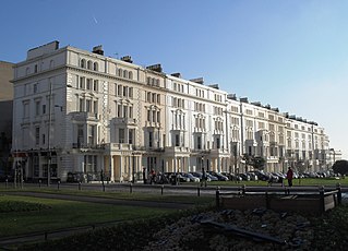
Palmeira Square is a mid-19th-century residential development in Hove, part of the English city and seaside resort of Brighton and Hove. At the southern end it adjoins Adelaide Crescent, another architectural set-piece which leads down to the seafront; large terraced houses occupy its west and east sides, separated by a public garden; and at the north end is one of Hove's main road junctions. This is also called Palmeira Square, and its north side is lined with late 19th-century terraced mansions. Commercial buildings and a church also stand on the main road, which is served by many buses.

<span class="mw-page-title-main">Adelaide Crescent</span> 19th century residences in Hove, England

Adelaide Crescent is a mid-19th-century residential development in Hove, part of the English city and seaside resort of Brighton and Hove. Conceived as an ambitious attempt to rival the large, high-class Kemp Town estate east of Brighton, the crescent was not built to its original plan because time and money were insufficient. Nevertheless, together with its northerly neighbour Palmeira Square, it forms one of Hove's most important architectural set-pieces. Building work started in 1830 to the design of Decimus Burton. The adjacent land was originally occupied by "the world's largest conservatory", the Anthaeum; its collapse stopped construction of the crescent, which did not resume until the 1850s. The original design was modified and the crescent was eventually finished in the mid-1860s. Together with the Kemp Town and Brunswick Town estates, the crescent is one of the foremost pre-Victorian residential developments in the Brighton area: it has been claimed that "outside Bath, [they] have no superior in England". The buildings in the main part of Adelaide Crescent are Grade II* listed. Some of the associated buildings at the sea-facing south end are listed at the lower Grade II.

References

  1. 1 2 3 Collis 2010 , p. 75.
  2. 1 2 Carder 1990 , §17.
  3. 1 2 Berry, Sue (1988): Brighton and Hove: Historical Geography, in s.n. 1998 , p. 15.
  4. Berry 2005 , p. 97.
  5. Myall 2008 , pp. 7–9.
  6. Berry, Sue (1988): Brighton and Hove: Historical Geography, in s.n. 1998 , p. 16.
  7. "Montpelier & Clifton Hill Conservation Area Character Statement" (PDF). Brighton & Hove City Council (Design & Conservation Department). 20 October 2005. pp. 1–2. Archived (PDF) from the original on 28 September 2011. Retrieved 6 September 2011.
  8. Collis 2010 , p. 73.
  9. Myall 2008 , p. 16.
  10. 1 2 Myall 2008 , p. 114.
  11. 1 2 3 Antram & Morrice 2008 , p. 169.
  12. Myall 2008 , pp. 114–115.
  13. Sampson 1994 , p. 56.
  14. 1 2 3 4 5 "Montpelier & Clifton Hill Conservation Area Character Statement" (PDF). Brighton & Hove City Council (Design & Conservation Department). 20 October 2005. p. 12. Archived (PDF) from the original on 28 September 2011. Retrieved 26 December 2011.
  15. Antram & Morrice 2008 , p. 168.
  16. "Montpelier & Clifton Hill Conservation Area Character Statement" (PDF). Brighton & Hove City Council (Design & Conservation Department). 20 October 2005. p. 2. Archived (PDF) from the original on 28 September 2011. Retrieved 26 December 2011.
  17. "Montpelier & Clifton Hill Conservation Area Character Statement" (PDF). Brighton & Hove City Council (Design & Conservation Department). 20 October 2005. p. 3. Archived (PDF) from the original on 28 September 2011. Retrieved 26 December 2011.
  18. Collis 2010 , p. 76.
  19. "Listed Buildings". English Heritage. 2012. Archived from the original on 26 January 2013. Retrieved 24 January 2013.
  20. "Images of England — Statistics by County (East Sussex)". Images of England . English Heritage. 2007. Archived from the original on 23 October 2012. Retrieved 27 December 2012.
  21. 1 2 3 Historic England (2011). "Nos. 1–6 (Consecutive) and attached railings, Vernon Terrace (North West side), The City of Brighton and Hove (1381070)". National Heritage List for England . Retrieved 26 December 2011.
  22. 1 2 3 Historic England (2011). "Nos. 7–16 (Consecutive) attached gate piers and balustrades, Vernon Terrace (North West side), The City of Brighton and Hove (1381071)". National Heritage List for England . Retrieved 26 December 2011.
  23. 1 2 3 4 Historic England (2011). "No. 37 and attached wall and piers, Vernon Terrace (West side), The City of Brighton and Hove (1381072)". National Heritage List for England . Retrieved 26 December 2011.
  24. "Conservation Areas in Brighton & Hove". Brighton & Hove City Council (Design & Conservation Department). 2010. Archived from the original on 30 August 2012. Retrieved 7 September 2011.
  25. "Montpelier & Clifton Hill Conservation Area Character Statement" (PDF). Brighton & Hove City Council (Design & Conservation Department). 20 October 2005. p. 1. Archived (PDF) from the original on 28 September 2011. Retrieved 26 December 2011.

Bibliography