The Battle of Bunker Hill was fought on June 17, 1775 during the Siege of Boston in the first stage of the American Revolutionary War. The battle is named after Bunker Hill in Charlestown, Massachusetts, which was peripherally involved. It was the original objective of both the colonial and British troops, though the majority of combat took place on the adjacent hill which became known as Breed's Hill.

Major-General John Stark was an American military officer who served during the French and Indian War and the Revolutionary War. He became known as the "Hero of Bennington" for his exemplary service at the Battle of Bennington in 1777.
Evacuation Day is a holiday observed on March 17 in Suffolk County, Massachusetts and also by the public schools in Somerville, Massachusetts. The holiday commemorates the evacuation of British forces from the city of Boston following the siege of Boston, early in the American Revolutionary War. Schools and government offices are closed. If March 17 falls on a weekend, schools and government offices are closed on the following Monday in observance. It is the same day as Saint Patrick's Day, a coincidence that played a role in the establishment of the holiday.

The Battle of Long Island, also known as the Battle of Brooklyn and the Battle of Brooklyn Heights, was an action of the American Revolutionary War fought on August 27, 1776, at the western edge of Long Island in present-day Brooklyn. The British defeated the Continental Army and gained access to the strategically important Port of New York, which they held for the rest of the war. It was the first major battle to take place after the United States declared its independence on July 4, 1776, in Philadelphia. It was the largest battle of the Revolutionary War in terms of both troop deployment and combat.
Richard Gridley was born in Boston, Massachusetts. He was a soldier and engineer who served for the British Army during the French and Indian Wars and for the Continental Army during the American Revolutionary War.
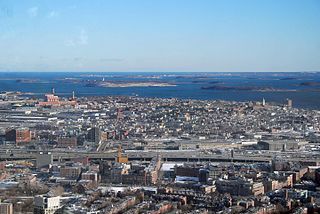
The siege of Boston was the opening phase of the American Revolutionary War. New England militiamen prevented the British Army from moving by land, and it was garrisoned in Boston, Massachusetts Bay. Both sides had to deal with resource, supply, and personnel issues over the course of the siege. British resupply and reinforcement was limited to sea access, which was impeded by American vessels. The British abandoned Boston after 11 months and transferred their troops and equipment to Nova Scotia.

The New York and New Jersey campaign in 1776 and the winter months of 1777 was a series of American Revolutionary War battles for control of the Port of New York and the state of New Jersey, fought between British forces under General Sir William Howe and the Continental Army under General George Washington. Howe was successful in driving Washington out of New York, but overextended his reach into New Jersey, and ended the New York and New Jersey campaign in January 1777 with only a few outposts near New York City under British control. The British held New York Harbor for the rest of the Revolutionary War, using it as a base for expeditions against other targets.
South Boston is a densely populated neighborhood of Boston, Massachusetts, located south and east of the Fort Point Channel and abutting Dorchester Bay. South Boston, colloquially known as Southie, has undergone several demographic transformations since being annexed to the city of Boston in 1804. The neighborhood, once primarily farmland, is popularly known by its twentieth century identity as a working class Irish Catholic community. Throughout the twenty-first century, the neighborhood has become increasingly popular with millennial professionals.

The Bunker Hill Monument is a monument erected at the site of the Battle of Bunker Hill in Boston, Massachusetts, which was among the first major battles between the Red Coats and Patriots in the American Revolutionary War. The 221-foot granite obelisk was erected between 1825 and 1843 in Charlestown, Massachusetts, with granite from nearby Quincy conveyed to the site via the purpose-built Granite Railway, followed by a trip by barge. There are 294 steps to the top.

Castle Island is a peninsula in South Boston on the shore of Boston Harbor. In 1928, Castle Island was connected to the mainland by a narrow strip of land and is thus no longer an island. It has been the site of a fortification since 1634, and is currently a 22-acre (8.9 ha) recreation site and the location of Fort Independence.
The Boston campaign was the opening campaign of the American Revolutionary War, taking place primarily in the Province of Massachusetts Bay. The campaign began with the Battles of Lexington and Concord on April 19, 1775, in which the local colonial militias interdicted a British government attempt to seize military stores and leaders in Concord, Massachusetts. The entire British expedition suffered significant casualties during a running battle back to Charlestown against an ever-growing number of militia.

The Boston National Historical Park is an association of sites that showcase Boston's role in the American Revolution and other parts of history. It was designated a national park on October 1, 1974. Seven of the eight sites are connected by the Freedom Trail, a walking tour of downtown Boston. All eight properties are National Historic Landmarks.

Evacuation Day on November 25 marks the day in 1783 when the British Army departed from New York City on Manhattan Island, after the end of the American Revolutionary War. In their wake, General George Washington triumphantly led the Continental Army from his headquarters north of the city across the Harlem River, and south through Manhattan to the Battery at its southern tip.

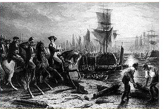
The Fortification of Dorchester Heights was a decisive action early in the American Revolutionary War that precipitated the end of the siege of Boston and the withdrawal of British troops from that city.

Fort Independence is a granite bastion fort that provided harbor defenses for Boston, Massachusetts, located on Castle Island. Fort Independence is one of the oldest continuously fortified sites of English origin in the United States. The first primitive fortification was called "The Castle", placed on the site in 1634. It was rebuilt twice, then replaced around 1692 with a more substantial structure known as Castle William. It was abandoned by the British during the American Revolution, but the Americans renamed it Fort Adams and then Fort Independence. The existing granite fort was constructed between 1833 and 1851. Today it is preserved as a state park and fires occasional ceremonial salutes. Fort Independence was added to the National Register of Historic Places in 1970.

John Eliot Square District is a historic district located in the northern Roxbury neighborhood of Boston, Massachusetts. It is formed by the intersection of Dudley, Bartlett, Centre, Roxbury and Highland Streets. Named after local missionary to the Indians, John Eliot, the square was the site of the Roxbury town center after its founding in 1630. Roxbury was annexed to Boston in 1868, and John Eliot Square was added to the National Register of Historic Places in 1973. The square is the nucleus of Roxbury Heritage State Park, a history-themed heritage park.

Fort Revere is an 8-acre (3.2 ha) historic site situated on a small peninsula located in Hull, Massachusetts. It is situated on Telegraph Hill in Hull Village and contains the remains of two seacoast fortifications, one from the American Revolution and one that served 1898–1947. There are also a water tower with an observation deck, a military history museum and picnic facilities. It is operated as Fort Revere Park by the Metropolitan Park System of Greater Boston.
The 26th Continental Regiment was an infantry unit of the Massachusetts Line during the American Revolutionary War. Gerrish's Regiment was raised in the early days of the war, and the regiment underwent name changes as the Continental Army was reorganized in 1776 and 1777. From 1777 onward, the unit was known as the 9th Massachusetts Regiment.

Fort Hill is a 0.4 square mile neighborhood and historic district of Roxbury, in Boston, Massachusetts. The approximate boundaries of Fort Hill are Malcolm X Boulevard on the north, Washington Street on the southeast, and Columbus Avenue on the southwest.
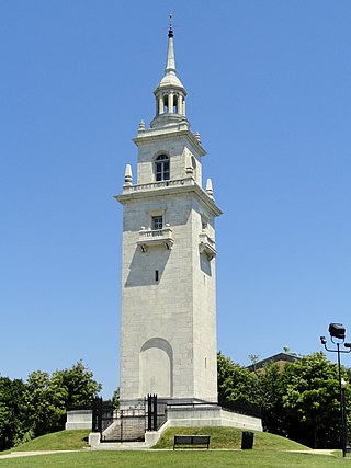
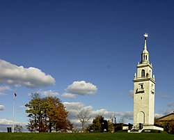
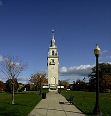
The Dorchester Heights Monument is a large public monument in the Dorchester Heights area of Boston, Massachusetts, United States. The monument, consisting of a 115-foot (35 m) marble tower, honors the evacuation of Boston during the American Revolutionary War, an early American victory in the conflict. The monument is located near where George Washington ordered the construction of a redoubt, an area which has since been developed as a public park. It was designed by the architectural firm of Peabody & Stearns and was dedicated on March 17, 1902.