List of peaks named Bear Mountain

Last updated

United States

According to the USGS GNIS, the United States has 144 peaks named Bear Mountain:

Contents

Alaska

According to the USGS GNIS, [1] the state of Alaska in the United States has 10 peaks named Bear Mountain:

NameUSGS linkStateCountyCoordinates
Bear Mountain Alaska Kenai Peninsula 60°04′53″N149°29′50″W / 60.08139°N 149.49722°W / 60.08139; -149.49722
Bear Mountain Alaska Kenai Peninsula 60°26′21″N150°05′48″W / 60.43917°N 150.09667°W / 60.43917; -150.09667
Bear Mountain Alaska Nome (CA) 65°19′34″N161°23′48″W / 65.32611°N 161.39667°W / 65.32611; -161.39667
Bear Mountain Alaska Prince of Wales-Outer Ketchikan (CA) 55°05′20″N133°12′07″W / 55.08889°N 133.20194°W / 55.08889; -133.20194
Bear Mountain Alaska Sitka City and Borough 57°03′01″N135°09′41″W / 57.05028°N 135.16139°W / 57.05028; -135.16139
Bear Mountain Alaska Yukon-Koyukuk (CA) 63°20′00″N160°20′00″W / 63.33333°N 160.33333°W / 63.33333; -160.33333
Bear Mountain Alaska Yukon-Koyukuk (CA) 65°47′50″N155°16′21″W / 65.79722°N 155.27250°W / 65.79722; -155.27250
Bear Mountain Alaska Yukon-Koyukuk (CA) 65°59′41″N142°49′15″W / 65.99472°N 142.82083°W / 65.99472; -142.82083
Bear Mountain Alaska Yukon-Koyukuk (CA) 66°03′31″N142°35′13″W / 66.05861°N 142.58694°W / 66.05861; -142.58694
Bear Mountain Alaska Yukon-Koyukuk (CA) 68°24′33″N142°04′21″W / 68.40917°N 142.07250°W / 68.40917; -142.07250

Arkansas

NameUSGS linkStateCountyCoordinates
Bear Mountain Arkansas Cleburne 35°37′23″N092°04′03″W / 35.62306°N 92.06750°W / 35.62306; -92.06750
Bear Mountain Arkansas Logan 35°13′45″N093°20′50″W / 35.22917°N 93.34722°W / 35.22917; -93.34722
Bear Mountain Arkansas Montgomery 34°29′00″N093°37′22″W / 34.48333°N 93.62278°W / 34.48333; -93.62278
Bear Mountain Arkansas Polk 34°28′48″N094°06′39″W / 34.48000°N 94.11083°W / 34.48000; -94.11083
Bear Mountain Arkansas Searcy 35°45′32″N092°48′06″W / 35.75889°N 92.80167°W / 35.75889; -92.80167

Arizona

NameUSGS linkStateCountyCoordinates
Bear Mountain Arizona Gila 33°56′07″N110°32′05″W / 33.93528°N 110.53472°W / 33.93528; -110.53472
Bear Mountain Arizona Greenlee 33°32′00″N109°08′38″W / 33.53333°N 109.14389°W / 33.53333; -109.14389
Bear Mountain Arizona Yavapai 34°54′50″N112°58′34″W / 34.91389°N 112.97611°W / 34.91389; -112.97611
Bear Mountain Arizona Yavapai 34°55′07″N111°53′01″W / 34.91861°N 111.88361°W / 34.91861; -111.88361

California

NameUSGS linkStateCountyCoordinates
Bear Mountain California Calaveras 38°01′10″N120°34′58″W / 38.01944°N 120.58278°W / 38.01944; -120.58278
Bear Mountain California Fresno 36°44′49″N119°16′47″W / 36.74694°N 119.27972°W / 36.74694; -119.27972
Bear Mountain California Fresno 37°05′46″N119°05′36″W / 37.09611°N 119.09333°W / 37.09611; -119.09333
Bear Mountain California Kern 35°12′18″N118°38′14″W / 35.20500°N 118.63722°W / 35.20500; -118.63722
Bear Mountain California Lake 39°24′24″N122°54′00″W / 39.40667°N 122.90000°W / 39.40667; -122.90000
Bear Mountain California Modoc 41°34′16″N120°15′27″W / 41.57111°N 120.25750°W / 41.57111; -120.25750
Bear Mountain California Monterey 36°09′31″N121°22′32″W / 36.15861°N 121.37556°W / 36.15861; -121.37556
Bear Mountain California Santa Clara 37°13′44″N121°26′18″W / 37.22889°N 121.43833°W / 37.22889; -121.43833
Bear Mountain California Shasta 40°43′33″N122°15′29″W / 40.72583°N 122.25806°W / 40.72583; -122.25806
Bear Mountain California Siskiyou 41°18′07″N121°43′04″W / 41.30194°N 121.71778°W / 41.30194; -121.71778
Bear Mountain California Siskiyou 41°47′47″N123°40′15″W / 41.79639°N 123.67083°W / 41.79639; -123.67083
Bear Mountain California Tulare 36°35′48″N119°02′45″W / 36.59667°N 119.04583°W / 36.59667; -119.04583
Bear Mountain California Tuolumne 37°51′19″N119°53′19″W / 37.85528°N 119.88861°W / 37.85528; -119.88861
Bear Mountain California Ventura 34°42′18″N118°53′29″W / 34.70500°N 118.89139°W / 34.70500; -118.89139

Colorado

According to the USGS GNIS, [2] the state of Colorado in the United States has 10 peaks named Bear Mountain:

NameUSGS linkStateCountyCoordinates
Bear Mountain Colorado Archuleta 37°10′44″N106°51′25″W / 37.17889°N 106.85694°W / 37.17889; -106.85694
Bear Mountain Colorado Douglas 39°22′08″N105°08′38″W / 39.36889°N 105.14389°W / 39.36889; -105.14389
Bear Mountain Colorado Fremont 38°27′23″N105°39′39″W / 38.45639°N 105.66083°W / 38.45639; -105.66083
Bear Mountain Colorado Grand 40°59′54″N106°32′03″W / 40.99833°N 106.53417°W / 40.99833; -106.53417
Bear Mountain Colorado Gunnison 39°02′07″N107°06′40″W / 39.03528°N 107.11111°W / 39.03528; -107.11111
Bear Mountain Colorado Hinsdale 37°26′13″N107°21′43″W / 37.43694°N 107.36194°W / 37.43694; -107.36194
Bear Mountain Colorado Jackson 40°46′58″N106°36′40″W / 40.78278°N 106.61111°W / 40.78278; -106.61111
Bear Mountain Colorado Larimer 40°39′37″N105°23′52″W / 40.66028°N 105.39778°W / 40.66028; -105.39778
Bear Mountain Colorado San Juan 37°47′41″N107°43′56″W / 37.79472°N 107.73222°W / 37.79472; -107.73222
Bear Mountain Colorado Summit 39°34′20″N105°54′11″W / 39.57222°N 105.90306°W / 39.57222; -105.90306

Connecticut

NameUSGS linkStateCountyCoordinates
Bear Mountain Connecticut Fairfield 41°26′57″N073°27′26″W / 41.44917°N 73.45722°W / 41.44917; -73.45722
Bear Mountain Connecticut Litchfield 42°02′41″N073°27′19″W / 42.04472°N 73.45528°W / 42.04472; -73.45528

Idaho

NameUSGS linkStateCountyCoordinates
Bear Mountain Idaho Bonner 48°18′31″N116°04′02″W / 48.30861°N 116.06722°W / 48.30861; -116.06722
Bear Mountain Idaho Custer 44°21′27″N113°27′06″W / 44.35750°N 113.45167°W / 44.35750; -113.45167
Bear Mountain Idaho Idaho 46°25′53″N114°55′28″W / 46.43139°N 114.92444°W / 46.43139; -114.92444

Maine

According to the USGS GNIS, the state of Maine in the United States has 11 peaks named Bear Mountain:

NameUSGS linkStateCountyCoordinates
Bear Mountain Maine Aroostook 46°07′15″N068°25′02″W / 46.12083°N 68.41722°W / 46.12083; -68.41722
Bear Mountain Maine Oxford 44°09′24″N070°42′32″W / 44.15667°N 70.70889°W / 44.15667; -70.70889
Bear Mountain Maine Oxford 44°21′53″N070°16′39″W / 44.36472°N 70.27750°W / 44.36472; -70.27750
Bear Mountain Maine Oxford 44°26′56″N070°57′20″W / 44.44889°N 70.95556°W / 44.44889; -70.95556
Bear Mountain Maine Penobscot 45°15′43″N068°17′30″W / 45.26194°N 68.29167°W / 45.26194; -68.29167
Bear Mountain Maine Penobscot 45°18′21″N068°05′45″W / 45.30583°N 68.09583°W / 45.30583; -68.09583
Bear Mountain Maine Penobscot 46°01′21″N068°39′21″W / 46.02250°N 68.65583°W / 46.02250; -68.65583
Bear Mountain Maine Piscataquis 46°18′20″N069°20′33″W / 46.30556°N 69.34250°W / 46.30556; -69.34250
Bear Mountain Maine Somerset 44°40′12″N069°45′07″W / 44.67000°N 69.75194°W / 44.67000; -69.75194
Bear Mountain Maine Somerset 45°22′06″N070°19′23″W / 45.36833°N 70.32306°W / 45.36833; -70.32306
Bear Mountain Maine Washington 45°20′41″N067°49′14″W / 45.34472°N 67.82056°W / 45.34472; -67.82056

Massachusetts

NameUSGS linkStateCountyCoordinates
Bear Mountain Massachusetts Franklin 42°29′10″N072°51′08″W / 42.48611°N 72.85222°W / 42.48611; -72.85222
Bear Mountain Massachusetts Franklin 42°35′10″N072°23′40″W / 42.58611°N 72.39444°W / 42.58611; -72.39444

Missouri

NameUSGS linkStateCountyCoordinates
Bear Mountain Missouri Douglas 36°51′38″N092°13′40″W / 36.86056°N 92.22778°W / 36.86056; -92.22778
Bear Mountain Michigan Menominee 45°21′15″N087°51′14″W / 45.35417°N 87.85389°W / 45.35417; -87.85389
Bear Mountain Missouri Reynolds 37°03′17″N090°47′22″W / 37.05472°N 90.78944°W / 37.05472; -90.78944

Montana

NameUSGS linkStateCountyCoordinates
Bear Mountain Montana Deer Lodge 45°54′38″N113°00′27″W / 45.91056°N 113.00750°W / 45.91056; -113.00750
Bear Mountain Montana Glacier 48°57′23″N113°45′24″W / 48.95639°N 113.75667°W / 48.95639; -113.75667
Bear Mountain Montana Jefferson 46°13′21″N112°19′44″W / 46.22250°N 112.32889°W / 46.22250; -112.32889
Bear Mountain Montana Meagher 46°13′01″N110°33′43″W / 46.21694°N 110.56194°W / 46.21694; -110.56194
Bear Mountain Montana Phillips 47°56′05″N108°28′14″W / 47.93472°N 108.47056°W / 47.93472; -108.47056

New Hampshire

NameUSGS linkStateCountyCoordinates
Bear Mountain New Hampshire Carroll 44°01′49″N071°18′09″W / 44.03028°N 71.30250°W / 44.03028; -71.30250
Bear Mountain New Hampshire Cheshire 42°49′34″N072°29′32″W / 42.82611°N 72.49222°W / 42.82611; -72.49222
Bear Mountain New Hampshire Grafton 43°39′49″N071°48′37″W / 43.66361°N 71.81028°W / 43.66361; -71.81028
Bear Mountain New Mexico Catron 33°37′32″N107°45′20″W / 33.62556°N 107.75556°W / 33.62556; -107.75556

New Mexico

NameUSGS linkStateCountyCoordinates
Bear Mountain New Mexico Colfax 36°27′51″N105°05′41″W / 36.46417°N 105.09472°W / 36.46417; -105.09472
Bear Mountain New Mexico Grant 32°50′09″N108°21′29″W / 32.83583°N 108.35806°W / 32.83583; -108.35806
Bear Mountain New Mexico Grant 33°01′21″N108°49′45″W / 33.02250°N 108.82917°W / 33.02250; -108.82917
Bear Mountain New Mexico San Miguel 35°40′09″N105°29′04″W / 35.66917°N 105.48444°W / 35.66917; -105.48444
Bear Mountain New Mexico Taos 36°06′15″N105°36′22″W / 36.10417°N 105.60611°W / 36.10417; -105.60611

North Carolina

NameUSGS linkStateCountyCoordinates
Bear Mountain North Carolina Jackson 35°09′53″N083°04′53″W / 35.16472°N 83.08139°W / 35.16472; -83.08139
Bear Mountain North Carolina Wilkes 36°06′57″N080°59′55″W / 36.11583°N 80.99861°W / 36.11583; -80.99861

New York

NameUSGS linkStateCountyCoordinates
Bear Mountain New York Clinton 44°28′49″N073°54′50″W / 44.48028°N 73.91389°W / 44.48028; -73.91389
Bear Mountain New York Essex 43°49′37″N073°27′22″W / 43.82694°N 73.45611°W / 43.82694; -73.45611
Bear Mountain New York Essex 43°51′46″N073°38′43″W / 43.86278°N 73.64528°W / 43.86278; -73.64528
Bear Mountain New York Essex 44°03′02″N073°43′16″W / 44.05056°N 73.72111°W / 44.05056; -73.72111
Bear Mountain New York Hamilton 43°24′33″N074°24′18″W / 43.40917°N 74.40500°W / 43.40917; -74.40500
Bear Mountain New York Orange 41°18′46″N074°00′24″W / 41.31278°N 74.00667°W / 41.31278; -74.00667
Bear Mountain New York St. Lawrence 44°10′11″N074°44′09″W / 44.16972°N 74.73583°W / 44.16972; -74.73583
Bear Mountain New York St. Lawrence 44°11′45″N074°48′43″W / 44.19583°N 74.81194°W / 44.19583; -74.81194
Bear Mountain New York St. Lawrence 44°18′28″N074°57′15″W / 44.30778°N 74.95417°W / 44.30778; -74.95417
Bear Mountain New York St. Lawrence 44°31′22″N074°38′37″W / 44.52278°N 74.64361°W / 44.52278; -74.64361
Bear Mountain New York Warren 43°24′05″N073°55′12″W / 43.40139°N 73.92000°W / 43.40139; -73.92000

Oklahoma

NameUSGS linkStateCountyCoordinates
Bear Mountain Oklahoma Latimer 34°49′06″N095°06′56″W / 34.81833°N 95.11556°W / 34.81833; -95.11556
Bear Mountain Oklahoma McCurtain 34°09′23″N094°55′32″W / 34.15639°N 94.92556°W / 34.15639; -94.92556

Oregon

NameUSGS linkStateCountyCoordinates
Bear Mountain Oregon Douglas 43°11′20″N123°39′07″W / 43.18889°N 123.65194°W / 43.18889; -123.65194
Bear Mountain Oregon Jackson 42°39′06″N122°45′29″W / 42.65167°N 122.75806°W / 42.65167; -122.75806
Bear Mountain Oregon Lane 43°30′54″N122°14′08″W / 43.51500°N 122.23556°W / 43.51500; -122.23556
Bear Mountain Oregon Lane 43°50′35″N122°53′25″W / 43.84306°N 122.89028°W / 43.84306; -122.89028
Bear Mountain Oregon Lane 43°56′11″N122°38′05″W / 43.93639°N 122.63472°W / 43.93639; -122.63472
Bear Mountain Oregon Wallowa 45°21′51″N116°41′51″W / 45.36417°N 116.69750°W / 45.36417; -116.69750
Bear Mountain Oregon Wheeler 44°21′33″N119°49′59″W / 44.35917°N 119.83306°W / 44.35917; -119.83306

Pennsylvania

NameUSGS linkStateCountyUSGS mapCoordinatesElevation
Bear Mountain Pennsylvania Adams Arendtsville 39°57′55″N077°17′58″W / 39.96528°N 77.29944°W / 39.96528; -77.29944 1,601 ft488 m
Bear Mountain Pennsylvania Carbon Lehighton 40°52′25″N075°41′59″W / 40.87361°N 75.69972°W / 40.87361; -75.69972 1,673 ft510 m
Bear Mountain Pennsylvania Centre Woodward 40°53′54″N077°17′50″W / 40.89833°N 77.29722°W / 40.89833; -77.29722 1,870 ft570 m
Bear Mountain Pennsylvania Monroe Pocono Pines 41°05′15″N075°22′58″W / 41.08750°N 75.38278°W / 41.08750; -75.38278 1,942 ft592 m
Bear Mountain Pennsylvania Schuylkill Tower City 40°36′45″N076°36′48″W / 40.61250°N 76.61333°W / 40.61250; -76.61333 1,627 ft496 m
Bear Mountain Pennsylvania Sullivan Hillsgrove 41°29′19″N076°40′34″W / 41.48861°N 76.67611°W / 41.48861; -76.67611 2,005 ft611 m

Texas

NameUSGS linkStateCountyCoordinates
Bear Mountain Texas Eastland 32°29′00″N098°30′43″W / 32.48333°N 98.51194°W / 32.48333; -98.51194
Bear Mountain Texas Gillespie 30°19′34″N098°51′27″W / 30.32611°N 98.85750°W / 30.32611; -98.85750
Bear Mountain Texas Jack 33°02′37″N098°25′08″W / 33.04361°N 98.41889°W / 33.04361; -98.41889
Bear Mountain Texas Jack 33°23′40″N098°12′13″W / 33.39444°N 98.20361°W / 33.39444; -98.20361
Bear Mountain Texas Jeff Davis 30°40′30″N104°15′04″W / 30.67500°N 104.25111°W / 30.67500; -104.25111
Bear Mountain Texas Jeff Davis 30°47′59″N103°59′42″W / 30.79972°N 103.99500°W / 30.79972; -103.99500
Bear Mountain Texas Llano 30°40′03″N098°45′10″W / 30.66750°N 98.75278°W / 30.66750; -98.75278

Virginia

NameUSGS linkStateCountyCoordinates
Bear Mountain Virginia Amherst 37°34′56″N079°08′13″W / 37.58222°N 79.13694°W / 37.58222; -79.13694
Bear Mountain Virginia Highland 38°20′12″N079°32′55″W / 38.33667°N 79.54861°W / 38.33667; -79.54861
Bear Mountain Virginia Highland 38°26′48″N079°41′27″W / 38.44667°N 79.69083°W / 38.44667; -79.69083

Vermont

NameUSGS linkStateCountyCoordinates
Bear Mountain Vermont Bennington 43°12′03″N073°10′02″W / 43.20083°N 73.16722°W / 43.20083; -73.16722
Bear Mountain Vermont Essex 44°38′01″N071°34′45″W / 44.63361°N 71.57917°W / 44.63361; -71.57917
Bear Mountain Vermont Rutland 43°28′13″N072°56′21″W / 43.47028°N 72.93917°W / 43.47028; -72.93917
Bear Mountain Vermont Rutland 43°36′27″N072°48′18″W / 43.60750°N 72.80500°W / 43.60750; -72.80500
Bear Mountain Vermont Windsor 43°30′36″N072°46′22″W / 43.51000°N 72.77278°W / 43.51000; -72.77278
Bear Mountain Vermont Windsor 43°52′13″N072°57′20″W / 43.87028°N 72.95556°W / 43.87028; -72.95556

Washington

According to the USGS GNIS, the state of Washington in the United States has 9 peaks named Bear Mountain. [3]

NameUSGS linkStateCountyUSGS mapCoordinatesElevation
Bear Mountain Washington Stevens Turtle Lake 47°58′11″N118°04′06″W / 47.96972°N 118.06833°W / 47.96972; -118.06833 3,445 ft1,050 m
Bear Mountain Washington Whatcom Mount Redoubt 48°55′49″N121°20′29″W / 48.93028°N 121.34139°W / 48.93028; -121.34139 7,877 ft2,401 m
Bear Mountain Washington Pacific Knappton 46°17′51″N123°49′12″W / 46.29750°N 123.82000°W / 46.29750; -123.82000 1,014 ft309 m
Bear Mountain Washington Clallam Mount Zion 47°57′38″N123°04′00″W / 47.96056°N 123.06667°W / 47.96056; -123.06667 3,412 ft1,040 m
Bear Mountain Washington Chelan Winesap 47°49′56″N120°09′56″W / 47.83222°N 120.16556°W / 47.83222; -120.16556 3,566 ft1,087 m
Bear Mountain Washington Okanogan Loup Loup Summit 48°24′47″N119°55′23″W / 48.41306°N 119.92306°W / 48.41306; -119.92306 5,446 ft1,660 m
Bear Mountain Washington Ferry Bear Mountain 48°31′46″N118°38′08″W / 48.52944°N 118.63556°W / 48.52944; -118.63556 4,580 ft1,400 m
Bear Mountain Washington Snohomish Evergreen Mountain 47°52′19″N121°21′24″W / 47.87194°N 121.35667°W / 47.87194; -121.35667 5,364 ft1,635 m
Bear Mountain Washington Whatcom Cavanaugh Creek 48°39′38″N122°01′17″W / 48.66056°N 122.02139°W / 48.66056; -122.02139 4,209 ft1,283 m

Wyoming

NameUSGS linkStateCountyCoordinates
Bear Mountain Wyoming Big Horn 44°22′17″N107°25′57″W / 44.37139°N 107.43250°W / 44.37139; -107.43250
Bear Mountain Wyoming Carbon 41°04′30″N106°37′09″W / 41.07500°N 106.61917°W / 41.07500; -106.61917
Bear Mountain Wyoming Carbon 42°14′19″N107°05′37″W / 42.23861°N 107.09361°W / 42.23861; -107.09361
Bear Mountain Wyoming Goshen 41°40′34″N104°16′57″W / 41.67611°N 104.28250°W / 41.67611; -104.28250
Bear Mountain Wyoming Natrona 42°26′10″N106°32′28″W / 42.43611°N 106.54111°W / 42.43611; -106.54111

Other states

These are states that have only one peak named Bear Mountain.

NameUSGS linkStateCountyCoordinates
Bear Mountain Alabama St. Clair 33°46′05″N086°31′34″W / 33.76806°N 86.52611°W / 33.76806; -86.52611
Bear Mountain Georgia Cherokee 34°18′48″N084°38′53″W / 34.31333°N 84.64806°W / 34.31333; -84.64806
Bear Mountain Kentucky Madison 37°32′10″N084°15′29″W / 37.53611°N 84.25806°W / 37.53611; -84.25806
Bear Mountain Nevada Elko 41°55′21″N114°54′20″W / 41.92250°N 114.90556°W / 41.92250; -114.90556
Bear Mountain South Dakota Pennington 43°52′12″N103°44′37″W / 43.87000°N 103.74361°W / 43.87000; -103.74361
Bear Mountain West Virginia Pocahontas 38°26′49″N079°41′30″W / 38.44694°N 79.69167°W / 38.44694; -79.69167

Related Research Articles

Huerfano County, Colorado County in Colorado, US

Huerfano County is one of the 64 counties in the U.S. state of Colorado. As of the 2010 census, the population was 6,711. The county seat is Walsenburg. The county, whose name comes from the Spanish huérfano meaning "orphan", was named for the Huerfano Butte, a local landmark. The area of Huerfano County boomed early in the 1900s with the discovery of large coal deposits. After large scale World War II coal demand ended in the 1940s Walsenburg and Huerfano saw a steady economic decline through 2015.

Chehalis River (Washington) River in Washington state, United States

The Chehalis River is a river in Washington in the United States. It originates in several forks in southwestern Washington, flows east, then north, then west, in a large curve, before emptying into Grays Harbor, an estuary of the Pacific Ocean.

Mount Katahdin Highest mountain in the US state of Maine

Mount Katahdin is the highest mountain in the U.S. state of Maine at 5,269 feet (1,606 m). Named Katahdin by the Penobscot Native Americans, which means "The Greatest Mountain", it is located within Northeast Piscataquis, Piscataquis County, and is the centerpiece of Baxter State Park. It is a steep, tall massif formed from a granite intrusion weathered to the surface. The flora and fauna on the mountain are typical of those found in northern New England.

Yampa River

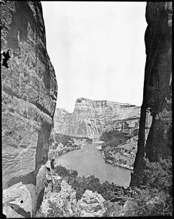
The Yampa River flows 250 miles (400 km) through northwestern Colorado in the United States. Rising in the Rocky Mountains, it is a tributary of the Green River and a major part of the Colorado River system. The Yampa is one of the few free-flowing rivers in the western United States, with only a few small dams and diversions.

Androscoggin River

The Androscoggin River is a river in the U.S. states of Maine and New Hampshire, in northern New England. It is 178 miles (286 km) long and joins the Kennebec River at Merrymeeting Bay in Maine before its water empties into the Gulf of Maine on the Atlantic Ocean. Its drainage basin is 3,530 square miles (9,100 km2) in area. The name "Androscoggin" comes from the Eastern Abenaki term /aləssíkɑntəkw/ or /alsíkɑntəkw/, meaning "river of cliff rock shelters" ; or perhaps from Penobscot /aləsstkɑtəkʷ/, meaning "river of rock shelters". The Anglicization of the Abenaki term is likely an analogical contamination with the colonial governor Edmund Andros.

Henry Gannett American geographer

Henry Gannett was an American geographer who is described as the "Father of the Quadrangle" which is the basis for topographical maps in the United States.

In mountaineering in the United States, a thirteener is a mountain that exceeds 13,000 feet (3,962.4 m) above mean sea level, similar to the more familiar "fourteeners," which exceed 14,000 feet (4,267.2 m). In most instances, "thirteeners" refers only to those peaks between 13,000 and 13,999 feet in elevation.

Calfpasture River

The Calfpasture River is a river in the U.S. state of Virginia. It flows about 41.0 miles (66.0 km) from its source, Gordons Peak in the Allegheny Mountains, to its confluence with the Little Calfpasture River, forming the Maury River. Via the Maury, the Calfpasture's waters flow into the James River, thence Chesapeake Bay and the Atlantic Ocean.

Washington Township, Hamilton County, Indiana Township in Indiana, United States

Westfield Washington Township is one of nine townships in Hamilton County, Indiana, United States. As of the 2010 census, its population was 32,884 and it contained 12,477 housing units. In 2007, the township had 29,361 residents. Due to Clay Township becoming more conservative with development due to a reduction in available land over the past few years, Westfield Washington Township has seen an increase in residential communities being developed.

Mount Fernow

Mount Fernow is a tall peak in the North Cascades in the U.S. state of Washington and within the Glacier Peak Wilderness of the Wenatchee National Forest. At 9,249 feet (2,819 m) in elevation it is the eighth-highest peak in Washington and the state's third-highest non-volcanic peak. It is also the highest peak of the Entiat Mountains, a sub-range of the Cascades. Mount Fernow's prominence is 2,811 ft (857 m), making it the sixtieth-most-prominent peak in Washington. The closest peak to Fernow is Copper Peak, 0.88 mi (1.42 km) to the north, and the nearest higher peak is Bonanza Peak, 5.9 mi (9.5 km) to the north.

Seven Fingered Jack

Seven Fingered Jack is a mountain in the North Cascades in the U.S. state of Washington. It is located at the north end of the Entiat Mountains, a sub-range of the Cascade Range. It is part of a three-peak group called the Entiat Cirque which includes Mount Maude and Mount Fernow. Seven Fingered Jack is about 4 miles (6.4 km) south of Holden. The peak is in the Glacier Peak Wilderness of Wenatchee National Forest.

Denali–Mount McKinley naming dispute

The name of the highest mountain in North America became a subject of dispute in 1975, when the Alaska Legislature asked the U.S. federal government to officially change its name from "Mount McKinley" to "Denali". The mountain had been unofficially named Mount McKinley in 1896 by a gold prospector, and officially by the federal government of the United States in 1917 to commemorate William McKinley, who was President of the United States from 1897 until his assassination in 1901.

Sheep Creek is a geographical place name. With variations, the name is given to hundreds of bodies of water, roads, canals, reservoirs and populated areas in the United States and other countries. It is the name of a tributary to Lockyear Creek in Queensland, Australia, and the name of at least three bodies of water in Canada. The U.S. state of Montana has 85 different locales that bear that name or a derivation. The U.S. state of Idaho has 92 natural and man-made areas that incorporate Sheep Creek into their names. Nature areas that include trails named Sheep Creek can be found in Canada's Yukon Territory, Colorado's Larimer County and in Utah's Bryce Canyon National Park.

John Beaver Mertie Jr. (1888–1980) was a geologist for the USGS and a professor at Johns Hopkins University. He spent 30 years mapping Alaska in the early 1900s, so much so that a mountain range was named in his honour in 1986: the Mertie Mountains located in the Yukon–Charley Rivers National Preserve. The mountains extend 187 kilometres (116 mi) by 176 kilometres (109 mi), from the Tanana River to the Yukon River; the United States Board on Geographic Names' dedication to Mertie read he "did pioneering geologic studies in Alaska for over 40 years, with a major portion of the studies pertaining to the area of these mountains".

References

  1. "U.S. Board on Geographic Names" . Retrieved 2017-05-06.
  2. "U.S. Board on Geographic Names" . Retrieved 2017-05-06.
  3. Bear Mountain, Whatcom at Peakbagger.com