Related Research Articles

Mariner 2, an American space probe to Venus, was the first robotic space probe to conduct a successful planetary encounter. The first successful spacecraft in the NASA Mariner program, it was a simplified version of the Block I spacecraft of the Ranger program and an exact copy of Mariner 1. The missions of the Mariner 1 and 2 spacecraft are sometimes known as the Mariner R missions. Original plans called for the probes to be launched on the Atlas-Centaur, but serious developmental problems with that vehicle forced a switch to the much smaller Agena B second stage. As such, the design of the Mariner R vehicles was greatly simplified. Far less instrumentation was carried than on the Soviet Venera probes of this period—for example, forgoing a TV camera—as the Atlas-Agena B had only half as much lift capacity as the Soviet 8K78 booster. The Mariner 2 spacecraft was launched from Cape Canaveral on August 27, 1962, and passed as close as 34,773 kilometers (21,607 mi) to Venus on December 14, 1962.

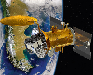
Envisat is a large inactive Earth-observing satellite which is still in orbit. Operated by the European Space Agency (ESA), it was the world's largest civilian Earth observation satellite.

A microwave radiometer (MWR) is a radiometer that measures energy emitted at millimetre-to-centimetre wavelengths known as microwaves. Microwave radiometers are very sensitive receivers designed to measure thermal electromagnetic radiation emitted by atmospheric gases. They are usually equipped with multiple receiving channels in order to derive the characteristic emission spectrum of the atmosphere or extraterrestrial objects. Microwave radiometers are utilized in a variety of environmental and engineering applications, including weather forecasting, climate monitoring, radio astronomy and radio propagation studies.

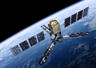
European Remote Sensing satellite (ERS) was the European Space Agency's first Earth-observing satellite programme using a polar orbit. It consisted of 2 satellites, ERS-1 and ERS-2.

NOAA-19, known as NOAA-N' before launch, is the last of the American National Oceanic and Atmospheric Administration (NOAA) series of weather satellites. NOAA-19 was launched on 6 February 2009. NOAA-19 is in an afternoon equator-crossing orbit and is intended to replace NOAA-18 as the prime afternoon spacecraft.

MetOp is a series of three polar-orbiting meteorological satellites developed by the European Space Agency (ESA) and operated by the European Organisation for the Exploitation of Meteorological Satellites (EUMETSAT). The satellites form the space segment component of the overall EUMETSAT Polar System (EPS), which in turn is the European half of the EUMETSAT / NOAA Initial Joint Polar System (IJPS). The satellites carry a payload comprising 11 scientific instruments and two which support Cospas-Sarsat Search and Rescue services. In order to provide data continuity between MetOp and NOAA Polar Operational Environmental Satellites (POES), several instruments are carried on both fleets of satellites.

GCOM, is a JAXA project of long-term observation of Earth environmental changes. As a part of Japan's contributions to GEOSS, GCOM will be continued for 10 to 15 years with observation and utilization of global geophysical data such as precipitation, snow, water vapor, aerosol, for climate change prediction, water management, and food security. On May 18, 2012, the first satellite "GCOM-W" was launched. On December 23, 2017, the second satellite "GCOM-C1" was launched.
Aquarius was a NASA instrument aboard the Argentine SAC-D spacecraft. Its mission was to measure global sea surface salinity to better predict future climate conditions.

Sentinel-3 is an Earth observation satellite constellation developed by the European Space Agency as part of the Copernicus Programme. It currently consists of 2 satellites: Sentinel-3A and Sentinel-3B. Two more satellites, Sentinel-3C and Sentinel-3D, are on order.
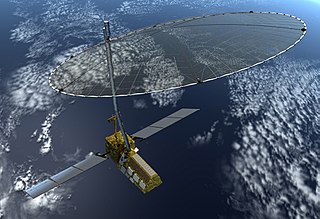
Soil Moisture and Ocean Salinity (SMOS) is a satellite which forms part of ESA's Living Planet Programme. It is intended to provide new insights into Earth's water cycle and climate. In addition, it is intended to provide improved weather forecasting and monitoring of snow and ice accumulation.
The Living Planet Programme (LPP) is a programme within the European Space Agency which is managed by the Earth Observation Programmes Directorate. LPP consists of two classes of Earth observation missions including research missions known as Earth Explorers, and the Earth Watch class of missions whose objective is to develop support operational applications such as numerical weather forecasting or resource management.
The Advanced Along Track Scanning Radiometer (AATSR) is one of the Announcement of Opportunity (AO) instruments on board the European Space Agency (ESA)'s Envisat satellite.
The European Student Moon Orbiter (ESMO) was a proposed European student mission to the Moon. Student teams from 19 universities throughout Europe worked on the program. ESMO was conceived by the Student Space Exploration & Technology Initiative under the support of the European Space Agency (ESA); prior to the start of Phase A the full responsibility for the management of the program was transferred to the ESA Education Office. In 2009, Surrey Satellite Technology Ltd (SSTL) was selected as prime contractor. ESMO was scheduled for launch in late 2013 or early 2014, but further ESA evaluation deemed the ESMO project's costs "unsustainable" given the ESA Education Office's budget.

Soil Moisture Active Passive (SMAP) is a NASA environmental monitoring satellite launched on 31 January 2015. It was one of the first Earth observation satellites developed by NASA in response to the National Research Council's Decadal Survey.

EarthCARE is a planned joint European/Japanese satellite, the sixth of ESA's Earth Explorer Programme. The main goal of the mission is the observation and characterization of clouds and aerosols as well as measuring the reflected solar radiation and the infrared radiation emitted from Earth's surface and atmosphere.
Sea ice concentration is a useful variable for climate scientists and nautical navigators. It is defined as the area of sea ice relative to the total at a given point in the ocean. This article will deal primarily with its determination from remote sensing measurements.
Sea ice thickness spatial extent, and open water within sea ice packs can vary rapidly in response to weather and climate. Sea ice concentration are measured by satellites, with the Special Sensor Microwave Imager / Sounder (SSMIS), and the European Space Agency's Cryosat-2 satellite to map the thickness and shape of the Earth's polar ice cover. The sea ice volume is calculated with the Pan-Arctic Ice Ocean Modeling and Assimilation System (PIOMAS), which blends satellite-observed data, such as sea ice concentrations into model calculations to estimate sea ice thickness and volume. Sea ice thickness determines a number of important fluxes such as heat flux between the air and ocean surface—see below—as well as salt and fresh water fluxes between the ocean since saline water ejects much of its salt content when frozen—see sea ice growth processes. It is also important for navigators on icebreakers since there is an upper limit to the thickness of ice any ship can sail through.
The NASA-ISRO Synthetic Aperture Radar (NISAR) mission is a joint project between NASA and ISRO to co-develop and launch a dual-frequency synthetic aperture radar on an Earth observation satellite. The satellite will be the first radar imaging satellite to use dual frequencies. It will be used for remote sensing, to observe and understand natural processes on Earth. For example, its left-facing instruments will study the Antarctic cryosphere.
BIOMASS is an Earth observing satellite planned for launch by the European Space Agency (ESA) in October 2022.

The Sentinel-6 Michael Freilich satellite is a radar altimeter satellite which was developed by European Space Agency (ESA) in the context of the European Copernicus Programme led by the European Commission, the European Organisation for the Exploitation of Meteorological Satellites (EUMETSAT), NASA, and the National Oceanic and Atmospheric Administration (NOAA), with funding support from the European Commission and technical support from France's National Centre for Space Studies.
References
- ↑ SMOS mission Payload, Living Planet Programme, ESA
- 1 2 SMOS: The Challenging Sea Surface Salinity Measurement from Space, J. Font, A. Camps, A. Borges, M. Martin-Neira, J. Boutin, N. Reul, Y. Kerr, A. Hahne and S. Mecklenburg, Proceedings of the IEEE, vol. 98, no. 5, May 2010, pp. 649-665
- ↑ Operating Principles Archived 2009-12-16 at the Wayback Machine SMOS Mission, ICM-CSIC (Spanish Institute of Marine Sciences – Spanish National Research Council), updated July 2008
- ↑ Last batch of LICEF receivers delivered for SMOS. Living Planet Programme. ESA