A blizzard is a severe snowstorm characterized by strong sustained winds and low visibility, lasting for a prolonged period of time—typically at least three or four hours. A ground blizzard is a weather condition where snow is not falling but loose snow on the ground is lifted and blown by strong winds. Blizzards can have an immense size and usually stretch to hundreds or thousands of kilometres.
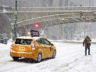
A winter storm is an event in which wind coincides with varieties of precipitation that only occur at freezing temperatures, such as snow, mixed snow and rain, or freezing rain. In temperate continental climates, these storms are not necessarily restricted to the winter season, but may occur in the late autumn and early spring as well. A snowstorm with strong winds and other conditions meeting certain criteria is called a blizzard.

The blizzard of 1977 hit Western New York and Southern Ontario from January 28 to February 1 of that year. Daily peak wind gusts ranging from 46 to 69 mph were recorded by the National Weather Service in Buffalo, with snowfall as high as 100 in (254 cm) recorded in areas, and the high winds blew this into drifts of 30 to 40 ft. There were 23 total storm-related deaths in Western New York, with five more in northern New York.

The 1993 Storm of the Century was a cyclonic storm that formed over the Gulf of Mexico on March 12, 1993. The cold weather, heavy snowfall, high winds and storm surges that the storm brought affected a very large area; at its height, it stretched from Canada to Honduras. The cyclone moved through the Gulf of Mexico and then through the eastern United States before moving on to eastern Canada. It eventually dissipated in the North Atlantic Ocean on March 15.
The Great Blizzard of 1978 was a historic winter storm that struck the Ohio Valley and Great Lakes regions of the United States as well as Southern Ontario in Canada from Wednesday, January 25 through Friday, January 27, 1978. It is often cited as one of the most severe blizzards in US history. The third lowest non-tropical atmospheric pressure ever recorded in the mainland United States occurred as the storm passed over Mount Clemens, Michigan, where barometer readings fell to 956.0 mb (28.23 inHg) on January 26.
The Blizzard of 1999 was a strong winter snowstorm which struck the Midwestern United States and portions of central and eastern Canada, hitting hardest in Iowa, Wisconsin, Illinois, Indiana, Michigan, Ohio, southern Ontario, and southern Quebec dumping as much as 60 centimetres (2 ft) of snow in many areas. Chicago received a recorded 21.6 in (55 cm). The storm hit just after New Year's Day, between January 2 and January 4, 1999. Travel was severely disrupted throughout the areas and the cities of Chicago and Toronto were also paralyzed. Additionally, record low temperatures were measured in many towns in the days immediately after the storm.

The Great Storm of 1975 was an intense storm system that impacted a large portion of the Central and Southeast United States from January 9 to January 12, 1975. The storm produced 45 tornadoes in the Southeast U.S. resulting in 12 fatalities, while later dropping over 2 feet (61 cm) of snow and killing 58 people in the Midwest. This storm remains one of the worst blizzards to ever strike parts of the Midwest, as well as one of the largest January tornado outbreaks on record in the United States.
The Early Winter 2006 North American storm complex was a severe winter storm that occurred on November 26, 2006, and continued into December 1. It affected much of North America in some form, producing various kinds of severe weather including a major ice storm, blizzard conditions, high winds, extreme cold, a serial derecho and some tornadoes.
The January 2007 North American ice storm was a severe ice storm that affected a large swath of North America from the Rio Grande Valley to New England and southeastern Canada, starting on January 11 and lasting until January 16. It was followed by a second wave in the Southern United States from Texas to the Carolinas from January 16 through January 18, and a third one that hit the southern Plains and mid-Atlantic states as well as Newfoundland and Labrador from January 19 to January 24. It resulted in at least 74 deaths across 12 U.S. states and three Canadian provinces, and caused hundreds of thousands of residents across the U.S. and Canada to lose electric power.

The North American blizzard of 2008 was a winter storm that struck most of southern and eastern North America from March 6 to March 10, 2008. The storm was most notable for a major winter storm event from Arkansas to Quebec. It also produced severe weather across the east coast of the United States with heavy rain, damaging winds and tornadoes, causing locally significant damage. The hardest hit areas by the wintry weather were from the Ohio Valley to southern Quebec where up to a half a meter of snow fell locally including the major cities of Columbus, Ohio, Cleveland, Ohio, and Ottawa, Ontario. For many areas across portions of the central United States, Ontario and Quebec, it was the worst winter storm in the past several years. The blizzard and its aftermath caused at least 17 deaths across four US states and three Canadian provinces, while hundreds others were injured mostly in weather-related accidents and tornadoes.

The February 9–10, 2010 North American blizzard was a winter and severe weather event that afflicted the Midwest, Mid-Atlantic and New England regions of the United States between February 9–11, 2010, affecting some of the same regions that had experienced a historic Nor'easter three days prior. The storm brought 10 to 20 inches of snow across a wide swath from Washington, DC to New York City, with parts of the Baltimore metro area receiving more than 20 inches (51 cm). This storm began as a classic "Alberta clipper", starting out in Canada and then moving southeast, and finally curving northeast while rapidly intensifying off the New Jersey coast, forming an eye. The National Weather Service, in an interview with The Baltimore Sun's weather reporter Frank Roylance, likened this storm to a Category 1 hurricane. Forecasters told Roylance that "Winds topped 58 mph over part of the Chesapeake Bay, and 40 mph gusts were common across the region as the storm's center deepened and drifted slowly along the mid-Atlantic coast". This storm system, in conjunction with the first storm 3 days prior, has been nicknamed Snoverkill.
Global weather activity of 2009 profiles the major worldwide storms, including blizzards, tornadoes, ice storms, tropical cyclones and other meteorogical events, from January 1, 2009, to December 31, 2009. Wintery storms are events in which the dominant varieties of precipitation are forms that only occur at cold temperatures, such as snow or sleet, or a rainstorm where ground temperatures are cold enough to allow ice to form. It may be marked by strong wind, thunder and lightning, heavy precipitation, such as ice, or wind transporting some substance through the atmosphere. Summer storms including flooding, severe thunderstorms and extratropical cyclones are also included in this list to a certain extent.

Global storm activity of 2008 profiles the major worldwide storms, including blizzards, ice storms, and other winter events, from January 1, 2008 to December 31, 2008. A winter storm is an event in which the dominant varieties of precipitation are forms that only occur at cold temperatures, such as snow or sleet, or a rainstorm where ground temperatures are cold enough to allow ice to form. It may be marked by strong wind, thunder and lightning, heavy precipitation, such as ice, or wind transporting some substance through the atmosphere. Major dust storms, Hurricanes, cyclones, tornados, gales, flooding and rainstorms are also caused by such phenomena to a lesser or greater existent.
Global weather activity of 2007 profiles the major worldwide weather events, including blizzards, ice storms, tornadoes, tropical cyclones, and other weather events, from January 1, 2007, to December 31, 2007. Winter storms are events in which the dominant varieties of precipitation are forms that only occur at cold temperatures, such as snow or sleet, or a rainstorm where ground temperatures are cold enough to allow ice to form. It may be marked by strong wind, thunder and lightning, heavy precipitation, such as ice, or wind transporting some substance through the atmosphere. Other major non winter events such as large dust storms, Hurricanes, cyclones, tornados, gales, flooding and rainstorms are also caused by such phenomena to a lesser or greater existent.
Global weather activity of 2006 profiles the major worldwide weather events, including blizzards, ice storms, tropical cyclones, tornadoes, and other weather events, from January 1, 2006, to December 31, 2006. Winter storms are events in which the dominant varieties of precipitation are forms that only occur at cold temperatures, such as snow or sleet, or a rainstorm where ground temperatures are cold enough to allow ice to form. It may be marked by strong wind, thunder and lightning, heavy precipitation, such as ice, or wind transporting some substance through the atmosphere. Other major non winter events such as large dust storms, Hurricanes, cyclones, tornados, gales, flooding and rainstorms are also caused by such phenomena to a lesser or greater existent.
The Chicago blizzard of 1967 struck northeast Illinois and northwest Indiana on January 26–27, 1967, with a record-setting 23 inches (58 cm) snow fall in Chicago and its suburbs before the storm abated the next morning. As of 2022, it remains the greatest snowfall in one storm in Chicago history. As the blizzard was a surprise during the day with people already at work or school, it stopped the city for a few days as people dug out. "The storm was a full-blown blizzard, with 50 mph-plus northeast wind gusts creating drifts as high as 15 feet."

The March 2013 nor'easter was a powerful nor'easter that affected much of the United States, most notably New England. On March 6, the system moved into the Mid-Atlantic region of the east coast, and intensified into a nor'easter, dumping up to 3 feet of snow in some places. By late March 6, 2013, the nor'easter had knocked out power to about 250,000 homes and businesses.

The 2018–19 North American winter was unusually cold within the Northern United States, with frigid temperatures being recorded within the middle of the season. Several notable events occurred, such as a rare snow in the Southeast in December, a strong cold wave and several major winter storms in the Midwest, and upper Northeast and much of Canada in late January and early February, record snowstorms in the Southwest in late February, deadly tornado outbreaks in the Southeast and a historic mid-April blizzard in the Midwest, but the most notable event of the winter was a record-breaking bomb cyclone that affected much of the Central United States and Canada in mid-March. Unlike previous winters, a developing weak El Niño was expected to influence weather patterns across North America. Overall, however, winter of 2018–19 was mild along the mid- and lower parts of the East Coast, the West Coast, and most of the southern Plains. Overall, the meteorological winter of 2018-19 became the wettest on record for the United States.

The April 2019 North American blizzard was a historic blizzard that occurred in the month of April in the Great Plains and the Midwest. As strong winds and heavy snowfall were anticipated to produce widespread reductions in visibility, a blizzard warning was issued from northeastern Colorado to southwestern Minnesota, including several large cities. Denver, Cheyenne, Mitchell and Kearney were all included. Winds gusted as high as 107 mph (172 km/h) at Pueblo West and more than 30 inches of snow fell in Wallace, South Dakota.

The 2019–20 North American winter was unusually warm for many parts of the United States; in many areas, neutral ENSO conditions controlled the weather patterns, resulting in the sixth-warmest winter on record, and many areas in the Northeastern United States saw one of the least snowy winters in years. In fact, Baltimore and Islip saw no snow in February for the first time. Some notable events still occurred, such as a powerful blizzard that impacted the Western United States in late November, a series of cold shots in January and February, a snowstorm within the Texas Panhandle and a late-season blizzard in the High Plains.