
A blizzard is a severe snowstorm characterized by strong sustained winds and low visibility, lasting for a prolonged period of time—typically at least three or four hours. A ground blizzard is a weather condition where snow is not falling but loose snow on the ground is lifted and blown by strong winds. Blizzards can have an immense size and usually stretch to hundreds or thousands of kilometres.

The North American blizzard of 1996 was a severe nor'easter that paralyzed the United States East Coast with up to 4 feet (1.2 m) of wind-driven snow from January 6 to January 8, 1996. The City University of New York reported that the storm "dropped 20 inches of snow, had wind gusts of 50 mph and snow drifts up to 8 feet high." This storm was a classic example of a nor'easter, but the storm would not have been as historically significant without the presence of the arctic high pressure system located to the north of New York. It was followed by another storm, an Alberta Clipper, on January 12, then unusually warm weather and torrential rain which caused rapid melting and river flooding in the Northeast Floods later that month. Along with the March Superstorm of 1993 and the January 2016 United States blizzard, it is one of only three snowstorms to receive the top rating of 5, or "Extreme", on the Northeast Snowfall Impact Scale (NESIS).
The December 2005 North American ice storm was a damaging winter storm that produced extensive ice damage in a large portion of the Southern United States from December 14–16, 2005, while extensive snowfall was reported across portions of the Canadian provinces of Ontario and Quebec. The ice storm led to enormous and widespread power outages, and at least 7 deaths.

The North American blizzard of 2006 was a nor'easter that began on the evening of February 11, 2006. It dumped heavy snow across the Mid-Atlantic and New England states, from Virginia to Maine through the early evening of February 12, and ended in Atlantic Canada on February 13. The major cities from Baltimore to Boston received at least a foot of snow, with a second-highest amount of 26.9 inches (68 cm) in New York City, the most since at least 1869, the start of record keeping, only broken by the January 2016 United States blizzard nearly 10 years later.
The Blizzard of 1999 was a strong winter snowstorm which struck the Midwestern United States and portions of central and eastern Canada, hitting hardest in Iowa, Wisconsin, Illinois, Indiana, Michigan, Ohio, southern Ontario, and southern Quebec dumping as much as 60 centimetres (2 ft) of snow in many areas. Chicago received a recorded 21.6 in (55 cm). The storm hit just after New Year's Day, between January 2 and January 4, 1999. Travel was severely disrupted throughout the areas and the cities of Chicago and Toronto were also paralyzed. Additionally, record low temperatures were measured in many towns in the days immediately after the storm.
The Early Winter 2006 North American storm complex was a severe winter storm that occurred on November 26, 2006, and continued into December 1. It affected much of North America in some form, producing various kinds of severe weather including a major ice storm, blizzard conditions, high winds, extreme cold, a serial derecho and some tornadoes.
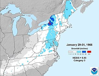
The Blizzard of 1966 was a nor'easter that impacted the northeastern United States and Eastern Canada from January 29-February 1, 1966. Heavy lake effect snows preceded the cyclonic storm southeast of Lake Ontario. In and around the Lake Ontario snow belt, the storm period is considered to have lasted from January 27 - February 1, 1966, and the blizzard was a combination nor' easter and lake effect event in this region.

The February 2007 North American blizzard was a massive winter storm that affected most of the eastern half of North America, starting on February 12, 2007 and peaking on Valentine's Day, February 14. The storm produced heavy snowfalls across the midwestern United States from Nebraska to Ohio and produced similar conditions across parts of the northeastern United States, and into Canada in Ontario, Quebec and New Brunswick. Significant sleet and freezing rain fell across the southern Ohio Valley and affected portions of the east coast of the United States, including the cities of Boston, Baltimore, Washington, D.C., New York City and Philadelphia.
The Early December 2007 North American winter storm was a major winter storm which affected the majority of the United States and portions of southern Canada from November 29 to December 5, hitting the Intermountain West and Midwestern United States, the Great Lakes region and the Northeast. The storm brought significant snows to portions of the Upper Midwest, Great Plains and Great Lakes regions of the United States and Canada on December 1 with a major winter storm for Quebec, Ontario and parts of the Northeast region on December 2 and 3 as well as the Canadian Maritimes on December 4 and 5. The system was also responsible for a major ice storm across the Midwestern states which caused disruptions to several major cities including Des Moines, Chicago, Detroit, Milwaukee and Toronto. The storm was blamed for at least 16 deaths across nine US states and one Canadian province. 10 traffic deaths had been reported, as of 2 December 2007.

The Mid-December 2007 North American winter storms were a series of two winter storms that affected much of central and eastern North America, from December 8 to December 18, 2007. The systems affected areas from Oklahoma to Newfoundland and Labrador with freezing rain, thunderstorms, sleet, snow, damaging winds, and blizzard-like conditions in various areas. The first two storms produced copious amounts of ice across the Midwestern United States and Great Plains from December 8 to December 11, knocking out power to approximately 1.5 million customers from Oklahoma north to Iowa. The second storm moved northeast, producing heavy snow across New York and New England. A third storm was responsible for a major winter storm from Kansas to the Canadian Maritimes, bringing locally record-breaking snowfalls to Ontario, an icestorm across the Appalachians, and thunderstorms and 9 tornadoes to the Southeastern United States.

The North American blizzard of 2008 was a winter storm that struck most of southern and eastern North America from March 6 to March 10, 2008. The storm was most notable for a major winter storm event from Arkansas to Quebec. It also produced severe weather across the east coast of the United States with heavy rain, damaging winds and tornadoes, causing locally significant damage. The hardest hit areas by the wintry weather were from the Ohio Valley to southern Quebec where up to a half a meter of snow fell locally including the major cities of Columbus, Ohio, Cleveland, Ohio, and Ottawa, Ontario. For many areas across portions of the central United States, Ontario and Quebec, it was the worst winter storm in the past several years. The blizzard and its aftermath caused at least 17 deaths across four US states and three Canadian provinces, while hundreds others were injured mostly in weather-related accidents and tornadoes.

Global storm activity of 2008 profiles the major worldwide storms, including blizzards, ice storms, and other winter events, from January 1, 2008 to December 31, 2008. A winter storm is an event in which the dominant varieties of precipitation are forms that only occur at cold temperatures, such as snow or sleet, or a rainstorm where ground temperatures are cold enough to allow ice to form. It may be marked by strong wind, thunder and lightning, heavy precipitation, such as ice, or wind transporting some substance through the atmosphere. Major dust storms, Hurricanes, cyclones, tornados, gales, flooding and rainstorms are also caused by such phenomena to a lesser or greater existent.
Global weather activity of 2007 profiles the major worldwide weather events, including blizzards, ice storms, tornadoes, tropical cyclones, and other weather events, from January 1, 2007, to December 31, 2007. Winter storms are events in which the dominant varieties of precipitation are formed during cold temperatures; they include snow or sleet, or a rainstorm where ground temperatures are cold enough to allow ice, including freezing rain, to form. Thehy may be marked by strong wind, thunder, lightning thunderstorms, heavy precipitation, including ice storm, wind transporting some substance through the atmosphere, including dust storms, snowstorms, and hail storms. Other major non winter events such as large dust storms, hurricanes, cyclones, tornados, gales, flooding, and rainstorms are also caused by such phenomena.
The March 2017 North American blizzard was a major late-season blizzard that affected the Northeastern United States, New England and Canada, dumping up to 3 feet of snow in the hardest hit areas, mainly New York, Vermont, New Hampshire and Southern Quebec. Forming out of an extratropical cyclone near the Northwest, the storm system dived into the northern portions of the United States, dropping light to moderate snow across the Great Lakes, Upper Midwest on March 11–12 before reaching the Ohio Valley the next day. It later coalesced into a powerful nor'easter off the East Coast, producing a swath of heavy snowfall across a large portion of the Northeast. The storm was given various unofficial names, such as Winter Storm Stella, Blizzard Eugene, and Blizzard of 2017.

The 2018–19 North American winter was unusually cold within the Northern United States, with frigid temperatures being recorded within the middle of the season. Several notable events occurred, such as a rare snow in the Southeast in December, a strong cold wave and several major winter storms in the Midwest, and upper Northeast and much of Canada in late January and early February, record snowstorms in the Southwest in late February, deadly tornado outbreaks in the Southeast and a historic mid-April blizzard in the Midwest, but the most notable event of the winter was a record-breaking bomb cyclone that affected much of the Central United States and Canada in mid-March. Unlike previous winters, a developing weak El Niño was expected to influence weather patterns across North America. Overall, however, winter of 2018–19 was mild along the mid- and lower parts of the East Coast, the West Coast, and most of the southern Plains. Overall, the meteorological winter of 2018-19 became the wettest on record for the United States.

The February 12–14, 2017 North American blizzard was a strong and historic nor'easter that affected the Northeastern United States and Eastern Canada from February 12–14. It impacted the Northeastern United States less than a week after the February 9–11, 2017 North American blizzard. This blizzard was more localized and less widespread than the previous storm, but snow totals were higher in some areas, including portions of Maine and Vermont. The system caused 2 fatalities and is estimated to have caused over $3.9 million in damages. It was unofficially named Winter Storm Orson by The Weather Channel.

The January 14–17, 2022 North American winter storm brought widespread impacts and wintry precipitation across large sections of eastern North America and parts of Canada. Forming out of a shortwave trough on January 13, it first produced a swath of snowfall extending from the High Plains to the Midwestern United States. The storm eventually pivoted east and impacted much of the Southern United States from January 15–16 before shifting north into Central Canada, the Mid-Atlantic states, and the Northeastern United States. The system, named Winter Storm Izzy by The Weather Channel, was described as a "Saskatchewan Screamer".

The January 2022 North American blizzard caused widespread and disruptive impacts to the Atlantic coast of North America from Delaware to Nova Scotia with as much as 2.5 feet (30 in) of snowfall, blizzard conditions and coastal flooding at the end of January 2022. Forming from the energy of a strong mid- to upper-level trough, the system developed into a low-pressure area off the Southeast United States on January 28. The system then quickly intensified that night as it traveled northeast parallel to the coast on January 29, bringing heavy snowfall blown by high winds to the East Coast of the continent. Further north, it also moved inland in Maine and its width meant it strongly impacted all three of Canada's Maritime provinces. In some areas, mainly the coastal regions of New Jersey, Long Island and Massachusetts, it was the first blizzard since a storm in January 2018. The storm was considered a "bomb cyclone" as it rapidly intensified and barometric pressure dropped at least 24 millibars over a 24-hour period. The storm was given names such as Blizzard of 2022 and Winter Storm Kenan.

The Great Snowstorm of 1944 was a distruptive winter storm that brought high winds and between 12 and 30 inches of snow to the eastern Great Lakes region of North America between Sunday, December 10, and Wednesday, December 13, 1944. The areas most affected included northeastern Ohio, western Pennsylvania, West Virginia, upstate New York, southern Ontario and southern Quebec.
The Great Lakes Blizzard of January 1971 affected almost the entire Great Lakes region of North America, as well as the western St. Lawrence Valley and northern New England between January 25 and 28, 1971 before a second severe snowstorm hit many of the same areas between January 28 and 31, 1971. The areas that felt the fiercest effects of the dual storms, that being moderate or heavy snow, sustained high winds, and zero visibility due to blowing snow, included southern Wisconsin, most of Michigan, Southern Ontario, northeastern Ohio, northwestern Pennsylvania, most of upstate New York and Southern Quebec, while northern Wisconsin, northern Indiana, northeastern Ontario, and northern Vermont experienced blizzard conditions from the first of the storms.


