March 2021 North American blizzard

Last updated
andtornado outbreaks of 2021
March 2021 North American blizzard
Winter Storm Xylia on 3-14-2021.jpg
NASA satellite imagery of the winter storm over the Central United States on March 1

The March 2021 North American blizzard was a record-breaking blizzard in the Rocky Mountains and a significant snowstorm in the Upper Midwest that occurred in mid-March 2021. It brought Cheyenne, Wyoming their largest two-day snowfall on record, and Denver, Colorado their second-largest March snowfall on record. The storm originated from an extratropical cyclone in the northern Pacific Ocean in early March, arriving on the west coast of the United States by March 10. The storm moved into the Rocky Mountains on Saturday, March 13, dumping up to 2–3 feet (61–91 cm) of snow in some areas. It was unofficially given the name Winter Storm Xylia. [4] [5]

Contents

Thousands lost power and several areas received some of their heaviest late-season snowfall on record. The system caused at least $75 million in damage, although no fatalities were reported. [2] The system was also responsible for a tornado outbreak in the Texas Panhandle on March 13, spawning 21 confirmed tornadoes. These tornadoes caused $1.285 million in damage.

Meteorological history

On March 4, a new extratropical low formed over the north central Pacific, within a larger extratropical storm. The system quickly split off from the parent low, and over the next couple of days, the storm moved southeastward while gradually intensifying, before reaching a peak intensity of 980 millibars (29 inHg) on March 6. [6] Afterward, the storm stalled off the coast of the Pacific Northwest for the next couple of days, while weakening, with the storm shedding its frontal system and weakening to 1,000 millibars (30 inHg) by 09:00 UTC on March 8. [7] [8] On the next day, the storm slowly began to approach the West Coast, while developing multiple central lows in the process. [9] On March 10, the storm began moving ashore in California, while developing a new low-pressure center to the east, which became the dominant low by the next day, after the storm had moved inland. [10] [11] [12] The storm remained nearly stationary over the Western United States for another day, before resuming its eastward motion on March 12, as a disorganized storm system. [13] On the next day, the storm began approaching another system over the Central Plains while gradually strengthening, before merging with it early on March 14, with the winter storm organizing significantly and growing more powerful in the process. [14] [15] On the night of March 13–14, a powerful low-level jet stream channeled large amounts of moisture from the Gulf of Mexico across the Southern Plains and into the storm, which enhanced precipitation from the storm and also contributed to the strengthening of the system. [1] On March 14, the winter storm developed a secondary low at the triple point of its occluded front, as the storm expanded in size. Later that day, the storm's central pressure reached a secondary peak of 998 millibars (29.5 inHg), while the storm was situated over the Central United States, with the center of low pressure being situated over southeastern Colorado. [16] [17] For much of that day, the storm's central low remained nearly stationary, even as it was intensifying. The storm's cyclogenesis resulted in a tightening of the pressure gradient, which gave the storm a large and expansive wind field. [1]

Afterward, the storm gradually began to weaken as it slowly moved eastward, even as it continued expanding in size. The storm's eastern flank continued moving farther apart from the parent low during this time. [18] From March 14 to 15, another extratropical cyclone moving in from the Pacific Northwest helped speed up the storm's eastward motion. [1] Throughout March 15, the winter storm weakened significantly, with the storm's western flank breaking off into a new storm over Northern United States, while the storm's secondary low to the east dissipated. The storm reached the Southeastern United States and the Mid-Atlantic region on March 16, even as the storm grew increasingly disorganized, with the storm's central pressure rising to 1,012 millibars (29.9 inHg) by 18:00 UTC that day. [19] [20] On March 17, the majority of the moisture from the winter storm was absorbed into a new storm developing off the coast of the Carolinas, as the former storm's low-pressure center stalled over West Virginia. Later that day, the winter storm dissipated over West Virginia. [21] [22]

Preparations

Winter Storm Warnings and Blizzard Warnings were issued from March 12–13 in much of the Rocky Mountains, where the heaviest of the snowfall was expected to occur.

Rocky Mountains

In Colorado, where the winter storm had the potential to be the biggest March snowstorm since 2003, officials urged residents to prepare ahead of the storm. On March 10, as the system was moving ashore in the West Coast, the Colorado Department of Transportation (CDOT) advised motorists to stay off the roads during the peak of the storm, due to potential whiteout and blizzard conditions being possible. [23] The city of Denver prepared to deploy snowplows ahead and during the storm to clear residential streets as needed. In addition, United Airlines offered waivers to flights expected to be impacted by the winter storm. [23]

Governor Mark Gordon of the state of Wyoming posted a warning on Twitter on March 13, advising residents to stay off the roads at all costs during the storm. [24] The Wyoming Department of Transportation (WYDOT) urged motorists to stay off the roads during the snow on March 12, and stated they were ready to deploy snow plows and materials to treat roadways. [25] Blizzard warnings were issued for parts of the state, including the city of Cheyenne, due to expected high wind gusts up to 50 mph (80 km/h) and heavy snowfall of up to 2 feet (24 in) expected. Blizzard warnings were later expanded southward along the Front Range to include Denver. In Sioux Falls, South Dakota, snow blew into traffic lights at intersections, making it impossible for drivers to tell if the lights were red, yellow or green. [26]

Southern Plains

On the morning of March 13, the Storm Prediction Center issued a moderate risk severe weather outlook for the Texas Panhandle, noting the potential for strong tornadoes. [27]

Impact

Rocky Mountains

The storm brought Cheyenne their largest two-day snowfall on record, with 30.8 inches (78 cm) falling from March 13–14. The storm closed schools and colleges, as well as city and state government buildings. [26] Schools and government offices also shut down in Casper. [26] Denver received their second-largest March snowfall on record, with 27.1 inches (69 cm) falling at the airport. [28] [26] The storm was also Denver's fourth-largest snowstorm on record. [28] [5] The storm shut down major highways, caused blizzard conditions across the region, forced more than 2,000 flights to be canceled and forced all runways to be closed at Denver International Airport, [29] and left tens of thousands of people without power. [4] [5] The Colorado Avalanche Information Center issued an avalanche warning for the Front Range area due to the heavy snow. [4] The Aurora Police Department in Colorado reported 25 to 30 vehicles were stranded on the E-470 toll road east of Denver. [26] Several interstate highways including Interstate 25, Interstate 70, Interstate 76 and Interstate 80 shut down. [3] Nearly 24,000 homes and businesses in Colorado remained without electricity on March 15. [26] The snowstorm also prevented the Los Angeles Kings to fly out of Denver, postponing a game against the St. Louis Blues. [30] Several school districts in South Dakota canceled classes due to the storm. [26] In Wyoming, schools in Laramie and Natrona counties announced they would be closed through the middle of the week as travel was nearly impossible. [31] The United States Postal Service also announced it is having difficulty delivering mail in some parts of Wyoming. [31] Outside of those two states, wind gusts reaching 69 mph (111 km/h) in Maeser, Utah. [3]

Midwest

Wind gusts reached 63 mph (101 km/h) in Ord, Nebraska and 59 mph (95 km/h) in Grand Island, Nebraska. [3]

In Minnesota, the State Patrol said 264 crashes were reported, and 22 of those involved injuries. [31] At least 13 tractor-trailers jackknifed and 251 vehicles spun out on the slick roadways. [31]

Southern Plains

Multiple tornadoes touched down across the Panhandle, mainly areas between Lubbock and Amarillo and points eastward. A large tornado prompted PDS tornado warnings for portions of Randall, Armstrong, and Carson counties. [32] [33] [34] [35] After surveys, it was determined an EF2 tornado moved from southwest of Happy in Swisher County to east of Canyon in Randall County. As the tornado dissipated, a new tornado, rated EF1, formed and moved into Armstrong County, passing over Palo Duro Canyon. A third tornado was spawned just northeast of the second one, also crossing from Randall to Armstrong and lifting near Washburn, just before crossing into Carson County. Another EF2 tornado caused minor damage in Clarendon before strengthening and causing major damage near the Greenbelt Lake Reservoir. [36] The final tornado of the day was a EF2 tornado that touched down southwest of Ensign and caused minor damage including several sturdy wood electrical poles that were snapped. [37] Damage totaled $1.285 million. [38]

Confirmed tornadoes by Enhanced Fujita rating
EFUEF0EF1EF2EF3EF4EF5Total
1044300021

Confirmed tornadoes

List of confirmed tornadoes – Saturday, March 13, 2021 [note 1]
EF# LocationCounty / ParishStateStart Coord.Time (UTC)Path lengthMax widthSummary
EFUWSW of Nazareth Castro TX 34°31′36″N102°09′02″W / 34.5267°N 102.1505°W / 34.5267; -102.1505 (Nazareth (March 13, EFU)) 20:55–20:570.92 mi (1.48 km)20 yd (18 m)A brief tornado was observed by a trained spotter. No damage occurred. [39]
EF2SW of Happy to ESE of Canyon Swisher, Randall TX 34°42′19″N101°59′13″W / 34.7054°N 101.9869°W / 34.7054; -101.9869 (Happy (March 13, EF2)) 21:15–22:0021.25 mi (34.20 km)1,000 yd (910 m)Many electrical transmission lines were damaged, a cell phone tower was blown over, and power poles were snapped along the path of this large wedge tornado. Homes sustained significant roof damage, including one that lost a large section of its roof and had considerable damage to its exterior. Damage also occurred to outbuildings, trees, and fencing. The tornado spent much of its life cycle over mostly open land. [40] [41] [36] [42] [43]
EF1NW of Happy Randall TX 34°48′04″N101°54′41″W / 34.8012°N 101.9115°W / 34.8012; -101.9115 (Happy #1 (March 13, EF1)) 21:31–21:362.5 mi (4.0 km)500 yd (460 m)This brief tornado was caught video by storm chasers and residents in the area. It was on the ground simultaneously with the EF2 tornado just to its south. A barn and power lines were damaged before the tornado was absorbed into the larger EF2 tornado. [44]
EF1N of Happy Randall TX 34°48′59″N101°51′27″W / 34.8163°N 101.8576°W / 34.8163; -101.8576 (Happy #2 (March 13, EF1)) 21:37–21:423.54 mi (5.70 km)100 yd (91 m)This was a satellite tornado on the southern side of the main EF2 tornado. Radar and reports and video from storm chasers suggest this was also an anticyclonic tornado. A brief tornado debris signature was visible on doppler radar in association with this tornado as it snapped power poles along Interstate 27. No other damage occurred as this tornado tracked northeast and dissipated. [45]
EF1E of Canyon Randall, Armstrong TX 34°58′35″N101°43′39″W / 34.9765°N 101.7275°W / 34.9765; -101.7275 (Palo Duro Canyon (March 13, EF1)) 21:48–22:148.16 mi (13.13 km)800 yd (730 m)This tornado was on the ground simultaneously with the Happy/Canyon EF2 tornado for several minutes as that tornado dissipated. Campgrounds were damaged at Palo Duro Canyon State Park. One cabin at the park lost its entire roof and travel trailers were flipped, including one which was destroyed. None of these trailers were anchored. Other damage at the state park including minor damage to weaker structures, and trees were damaged as well. The tornado became wider as it crossed Palo Duro Canyon. After crossing the canyon, the tornado traveled through a very rural area and lifted as another tornado formed in the vicinity. [40] [36] [46] [47]
EF0N of Hart Castro TX 34°25′25″N102°06′48″W / 34.4236°N 102.1134°W / 34.4236; -102.1134 (Hart (March 13, EF0)) 21:54–21:561.42 mi (2.29 km)30 yd (27 m)A brief tornado flipped an irrigation pivot and caused minor roof damage to a metal building. A Texas Tech West Texas mesonet station located north of Hart measured an 87 mph (140 km/h) wind gust as the tornado passed nearby. [48]
EFUSE of Nazareth Castro TX 34°31′29″N102°04′11″W / 34.5248°N 102.0696°W / 34.5248; -102.0696 (Nazareth (March 13, EFU)) 21:55–21:570.3 mi (0.48 km)30 yd (27 m)A brief tornado over open land was recorded on video and caused no damage. [49]
EF0E of Happy Swisher, Randall TX 34°44′01″N101°43′56″W / 34.7335°N 101.7323°W / 34.7335; -101.7323 (Happy (March 13, EF0)) 22:05–22:113.23 mi (5.20 km)50 yd (46 m)This tornado was caught on camera by storm chasers. Two power poles were broken in Swisher County. [50] [51]
EF0NNE of Palo Duro Canyon to ESE of Washburn Randall, Armstrong TX 35°00′41″N101°38′42″W / 35.0114°N 101.6449°W / 35.0114; -101.6449 (Washburn (March 13, EF0)) 22:06–22:3412.96 mi (20.86 km)1,000 yd (910 m)This tornado was on the ground simultaneously with the Palo Duro Canyon EF1 tornado for several minutes as that tornado dissipated. Power poles and several outbuildings were damaged. A semi-truck was pushed over before the tornado lifted after crossing U.S. Highway 287. The tornado occurred over mostly open land and was likely stronger than its rating indicates, but it impacted few structures. [52] [53]
EFUESE of Hale Center Hale TX 34°04′57″N101°41′48″W / 34.0825°N 101.6966°W / 34.0825; -101.6966 (Hale Center (March 13, EFU)) 22:210.04 mi (0.064 km)20 yd (18 m)A brief tornado was observed by storm spotters and caused no damage. [41] [54]
EFUNNE of Aiken Floyd TX 34°14′00″N101°29′16″W / 34.2333°N 101.4877°W / 34.2333; -101.4877 (Aiken (March 13, EFU)) 22:460.05 mi (0.080 km)20 yd (18 m)A very brief tornado was photographed by a trained spotter. No damage occurred. [55]
EFUSW of Groom Armstrong TX 35°07′30″N101°14′10″W / 35.1251°N 101.2360°W / 35.1251; -101.2360 (Groom (March 13, EFU)) 23:02–23:113.11 mi (5.01 km)800 yd (730 m)The damage path of this tornado was inaccessible by road, and it was confirmed by radar and storm chasers. [56]
EFUSW of Silverton Briscoe TX 34°27′01″N101°19′12″W / 34.4504°N 101.32°W / 34.4504; -101.32 (Silverton (March 13, EFU)) 23:080.06 mi (0.097 km)20 yd (18 m)A brief tornado in an open field was observed and photographed by storm spotters and caused no damage. [57]
EF2SSW of Clarendon to NE of Howardwick Donley TX 34°53′10″N100°55′45″W / 34.8861°N 100.9292°W / 34.8861; -100.9292 (Howardwick (March 13, EF2)) 23:48–00:1213.22 mi (21.28 km)1,200 yd (1,100 m)A tornado moved into the southwest edge of Clarendon, causing minor damage to homes and to Clarendon College, with sheet metal torn off the building. The tornado widened as it moved towards and then across Greenbelt Reservoir and into Howardwick. Mobile homes, recreational vehicles, and boating facilities were heavily damaged. One mobile home was completely destroyed, with debris from the structure scattered. Power poles were snapped, and many trees were snapped along the path. [40] [36] [58]
EF0 Clarendon Donley TX 34°56′05″N100°54′11″W / 34.9348°N 100.9031°W / 34.9348; -100.9031 (Clarendon (March 13, EF0)) 23:51–23:520.95 mi (1.53 km)40 yd (37 m)Brief, rain-wrapped tornado damaged several homes and sheds in town. Around ten homes sustained shingle damage to roofs, and several trees were downed. This tornado occurred simultaneously with and just east of the Clarendon–Howardwick EF2 tornado. [40] [36] [59]
EFUE of Lazare Hardeman TX 34°16′48″N99°57′54″W / 34.28°N 99.965°W / 34.28; -99.965 (Lazare (March 13, EFU)) 01:410.2 mi (0.32 km)50 yd (46 m)A brief tornado was observed by trained spotters. No damage occurred. [60]
EFUN of Goodlett Hardeman TX 34°23′00″N99°52′48″W / 34.3834°N 99.88°W / 34.3834; -99.88 (Goodlett (March 13, EFU)) 02:000.2 mi (0.32 km)30 yd (27 m)A brief tornado was reported by a trained spotter. No damage occurred. [61]
EF0WNW of Eldorado Jackson OK 34°29′24″N99°46′13″W / 34.49°N 99.7704°W / 34.49; -99.7704 (Eldorado (March 13, EFU)) 02:150.2 mi (0.32 km)30 yd (27 m)A brief tornado was reported by two trained spotters. No damage occurred. [62]
EFUS of McQueen Harmon OK 34°34′59″N99°42′00″W / 34.583°N 99.70°W / 34.583; -99.70 (McQueen (March 13, EFU)) 02:290.2 mi (0.32 km)20 yd (18 m)A brief tornado was observed by a trained spotter. No damage was reported, however, power flashes were observed with this tornado. [63]
EF1S of Reed Greer OK 34°46′01″N99°40′05″W / 34.767°N 99.668°W / 34.767; -99.668 (Reed (March 13, EF1)) 02:49–02:500.7 mi (1.1 km)50 yd (46 m)A tornado developed near the community of Russell and moved to the north-northeast. One shed, two tractors, and the porch of a home were damaged at a farm. Two sheds were destroyed at another farm. Some debris was scattered for 1.5 mi (2.4 km). [64]
EF2NNW of Fowler to WNW of Ensign Gray KS 37°29′55″N100°16′31″W / 37.4986°N 100.2752°W / 37.4986; -100.2752 (Fowler (March 13, EF2)) 03:22–03:3812.15 mi (19.55 km)100 yd (91 m)Near the start of the path, the tornado overturned a pivot irrigation sprinkler. As the tornado moved north-northeast, it snapped eight sturdy power poles, and destroyed a small grain bin. Another pivot irrigation sprinkler was overturned before the tornado lifted. Some ground scouring was observed in farm fields along the path. [40] [65]

See also

Notes

  1. All dates are based on the local time zone where the tornado touched down; however, all times are in Coordinated Universal Time for consistency.

Related Research Articles

<span class="mw-page-title-main">Satellite tornado</span> Tornado that orbits around a parent tornado

A satellite tornado is a tornado that revolves around a larger, primary tornado and interacts with the same mesocyclone. Satellite tornadoes occur apart from the primary tornado and are not considered subvortices; the primary tornado and satellite tornadoes are considered to be separate tornadoes. The cause of satellite tornadoes is not known. Such tornadoes are more often anticyclonic than are typical tornadoes and these pairs may be referred to as tornado couplets. Satellite tornadoes commonly occur in association with very powerful, large, and destructive tornadoes, indicative also of the strength and severity of the parent supercell thunderstorm.

<span class="mw-page-title-main">Tornado outbreak of February 23–24, 2016</span>

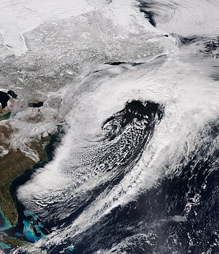
An unusually prolific and very destructive late-winter tornado outbreak resulted in significant damage and numerous casualties across the southern and eastern half of the United States between February 23–24, 2016. Lasting over a day and a half, the outbreak produced a total of 61 tornadoes across eleven states, which ranked it as one of the largest February tornado outbreaks in the United States on record, with only the 2008 Super Tuesday tornado outbreak having recorded more. In addition, it was also one of the largest winter tornado outbreaks overall as well. The most significant and intense tornadoes of the event were four EF3 tornadoes that struck southeastern Louisiana, Pensacola, Florida, Evergreen, Virginia, and Tappahannock, Virginia. Tornadoes were also reported in other places like Texas, Florida, and Pennsylvania. Severe thunderstorms, hail and gusty winds were also felt in the Northeastern United States and Mid-Atlantic states on February 24 as well.

<span class="mw-page-title-main">Tornado outbreak of February 7, 2017</span>

A small but damaging outbreak of 15 tornadoes impacted the Southeastern United States on February 7, 2017. The most damaging tornado of the outbreak was a large and powerful EF3 tornado. The tornado caused considerable damage along its path and left approximately 10,000 homes without electricity. 33 injuries occurred in the area after the tornado hit near Chef Menteur Highway with hundreds of structures sustaining moderate to significant damage along the ten-mile path. In response to the disaster, Governor John Bel Edwards declared a state of emergency.

<span class="mw-page-title-main">Tornado outbreak and floods of April 28 – May 1, 2017</span>

The tornado outbreak and floods of April 28 – May 1, 2017 were a series of severe weather events that affected the central United States, producing life-threatening flooding and a major tornado outbreak. It formed out of a disturbance in the Southwestern United States on April 28, and caused significant impacts, including a heavy snowstorm in the Rockies, and other types of severe weather. Up to 3 feet (36 in) of snow fell on the cold side of the system, and up to a foot of rain fell in and around the central parts of the nation.

<span class="mw-page-title-main">March 20–22, 2018 nor'easter</span> Cyclone

The March 20–22, 2018 nor'easter, dubbed the "Four'easter" in some media outlets, brought additional significant late-season snowfall to the Northeastern United States, after three previous such nor'easters had struck the general region on March 1–3, 6–8, and 12–15, respectively. affected the Mid-Atlantic states and New England with over 18 in (46 cm) of heavy snow and whiteout conditions. It also affected areas of the Southeastern and Midwestern United States with both snowfall and severe weather. The nor'easter was also one of the heaviest spring snowstorms on record in some areas in the Mid-Atlantic, especially Philadelphia and New York City.

<span class="mw-page-title-main">Tornado outbreak of January 10–11, 2020</span> American severe weather outbreak

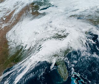
The tornado outbreak of January 10–11, 2020 was a two-day severe weather event stretching from the South-Central Plains eastward into the Southeast United States. An eastward-moving shortwave trough tracked across the continental United States through that two-day period, combining with abundant moisture, instability, and wind shear to promote the formation of a long-lived squall line. Hundreds of damaging wind reports were received, and 80 tornadoes occurred within this line, making it the third largest January tornado outbreak on record. Three tornadoes—an EF1 in eastern Texas, an EF2 in northern Louisiana, and an EF2 in western Alabama—led to a total of seven deaths, all in mobile homes. There were five other storm related deaths, including two due to icy roads in Lubbock, Texas, one due to drowning in Oklahoma, and one due to icy roads in Iowa. The system also brought a monthly record high temperature to Boston and Bridgeport. Extensive damage and several other injuries occurred as well. The severe weather event was notable in that it was forecast well in advance, with the Storm Prediction Center first highlighting the risk area a full week beforehand. Total damage from the event reached $1.1 billion according to the National Centers for Environmental Information.

<span class="mw-page-title-main">Tornado outbreak of April 21–23, 2020</span>

On April 22, 2020, an outbreak of discrete supercell thunderstorms across portions of Oklahoma, Texas, and Louisiana led to widespread severe weather, including multiple strong tornadoes. Two people were killed by a high-end EF2 that struck the town of Madill, Oklahoma, and three more were killed by an EF3 wedge tornado that moved through Onalaska, Texas. Dozens of others were injured as well. The event came to fruition as a trough progressed eastward across the United States, interacting with a moist and unstable environment. Tornado activity continued into Arkansas, Louisiana, Mississippi, Alabama, Florida, and Georgia overnight into the day on April 23. Isolated tornado activity also occurred during the overnight hours on April 21.

<span class="mw-page-title-main">Hurricane Isaias tornado outbreak</span> Outbreak of tornadoes in the eastern U.S. (2020)

As Hurricane Isaias moved up the East Coast of the United States, a damaging outbreak of 39 tornadoes impacted areas from South Carolina to Connecticut between August 3–4, 2020. The most significant tornado of the outbreak was a large and intense EF3 tornado that obliterated a mobile home park near Windsor, North Carolina, killing two and injuring 14. This was the strongest tornado in the United States to be spawned by a tropical cyclone since 2005. In the end, the outbreak killed two and injured 26.

<span class="mw-page-title-main">November 2020 North American storm complex</span>

The November 2020 North American storm complex was a major early-season snowstorm that impacted most of the Ohio Valley from November 30–December 2 with heavy snow, gusty winds, and near-whiteout conditions. The system originated from a weak gulf low off the coast of Texas on November 29, which began to move northeastward onto land the next day. It then began to strengthen, as well as slowing its movement down, resulting in heavy, wind-driven snow for prolonged periods of time in the Ohio Valley. It also triggered a major lake-effect snow event from December 1–2 as the system stalled over Lake Ontario, resulting in additional heavy snowfall. The storm system was also responsible for a severe thunderstorm outbreak in the Southeast and Mid-Atlantic regions, causing 22 severe thunderstorms and 5 tornadoes. In total, the system is estimated to have caused at least $100 million in damages. It was unofficially named Winter Storm Dane by The Weather Channel.

<span class="mw-page-title-main">Tornado outbreak of March 16–18, 2021</span> 2021 tornado outbreak and blizzard in the United States

A tornado outbreak occurred on Saint Patrick's Day in the Deep South. Mississippi and Alabama were greatly affected, with numerous tornadoes being confirmed, including four that were rated EF2. Six people were injured by four different tornadoes across Alabama during the outbreak. A non-tornadic fatality also occurred due to a car crash near Natchez, Mississippi. The outbreak began the day before, with a couple tornadoes in Mississippi, and continued over the next two days. The storm moved eastward and affected portions of Florida, Georgia, the Carolinas, and Virginia on March 18, spawning more tornadoes and causing wind damage before the storms pushed offshore that night. In total, 51 tornadoes were confirmed during the event, including 25 in Alabama, making it the sixth-largest tornado event in the state's history, and is sometimes locally referred to as the Saint Patrick's Day tornado outbreak of 2021. The same areas would be hit again by a more significant and destructive tornado outbreak sequence one week later.

<span class="mw-page-title-main">Tornado outbreak sequence of March 24–28, 2021</span> Outbreak of tornadoes and severe weather in the United States

A significant tornado outbreak sequence took place from March 24–28, 2021 in the Southern United States, just one week after another outbreak affected similar regions. There were 43 tornadoes confirmed across 11 states, with the bulk of activity primarily on March 25, which resulted in the Storm Prediction Center (SPC) issuing its second high-risk outlook for the month of March, as well as the second high-risk outlook for 2021. Several intense tornadoes touched down on that day, including ones that prompted the issuance of rare tornado emergencies near Hoover, Alabama, Brent and Centreville, Alabama, and in the Newnan, Georgia area. March 27 also saw widespread tornado activity mainly across East Texas, Southern Arkansas, Louisiana, and Western Tennessee with several strong tornadoes touching down. Scattered to widespread wind and hail damage occurred throughout the outbreak sequence, and repeated rounds of heavy rain caused widespread severe flash and river flooding across much of Tennessee.

<span class="mw-page-title-main">Tornado outbreak of July 28–29, 2021</span> Tornado outbreak in the Northern United States

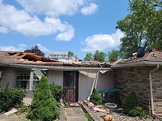
An unusually prolific summer tornado outbreak affected parts of the Northern United States from the late evening and overnight hours of July 28 into the early morning hours of July 29. It started with a powerful line of severe thunderstorms that produced widespread damaging straight-line winds and multiple embedded weak tornadoes across the state of Wisconsin. During the afternoon and evening of July 29, numerous tornadic supercells developed across portions of the Ohio Valley and Mid-Atlantic regions, producing many tornadoes. A few of the tornadoes were strong and damaging, including an EF3 tornado that caused severe damage in the Philadelphia suburbs of Trevose and Bensalem.

<span class="mw-page-title-main">Hurricane Ida tornado outbreak</span> 2021 tornado outbreak

Hurricane Ida generated a tornado outbreak as it traversed the Southeastern, Mid-Atlantic, and Northeastern United States. Thirty-five confirmed tornadoes touched down from Mississippi to Massachusetts; one person was killed in Upper Dublin Township, Pennsylvania, and several people were injured in Alabama, New Jersey, and Pennsylvania. The most active and destructive part of the outbreak occurred during the afternoon of September 1, when several strong tornadoes struck Maryland, New Jersey, and Pennsylvania, including an EF3 tornado which impacted Mullica Hill, New Jersey. The same storm later dropped an EF1 tornado that prompted a tornado emergency for Burlington, New Jersey and Croydon, and Bristol, Pennsylvania, the first of its kind in the Northeast, as well as the first such alert associated with a tropical cyclone or it's remnants. This outbreak severely impacted New Jersey and the Philadelphia Metropolitan Area, a region which had been significantly impacted by strong tornadoes from another outbreak that occurred just over a month prior, as well as several weak tornadoes from the remnants of Tropical Storm Fred two weeks earlier. Overall, the 36 tornadoes killed one person and injured seven others.

<span class="mw-page-title-main">October 2021 Northeast Pacific bomb cyclone</span> North American bomb cyclone in 2021

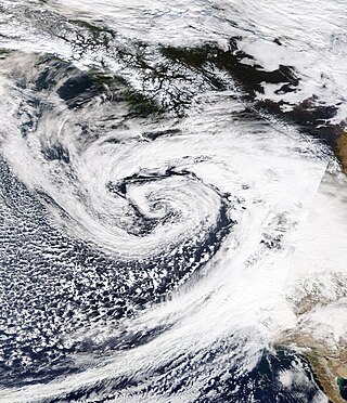
An extremely powerful extratropical bomb cyclone began in late October 2021 in the Northeast Pacific and struck the Western United States and Western Canada. The storm was the third and the most powerful cyclone in a series of powerful storms that struck the region within a week. The cyclone tapped into a large atmospheric river and underwent explosive intensification, becoming a bomb cyclone on October 24. The bomb cyclone had a minimum central pressure of 942 millibars (27.8 inHg) at its peak, making it the most powerful cyclone recorded in the Northeast Pacific. The system had severe impacts across Western North America, before dissipating on October 26. The storm shattered multiple pressure records across parts of the Pacific Northwest. Additionally, the bomb cyclone was the most powerful storm on record to strike the region, in terms of minimum central pressure. The bomb cyclone brought powerful gale-force winds and flooding to portions of Western North America. At its height, the storm cut the power to over 370,500 customers across the Western U.S. and British Columbia. The storm killed at least two people; damage from the storm was estimated at several hundred million dollars. The bomb cyclone was compared to the Columbus Day Storm of 1962, in terms of ferocity.

<span class="mw-page-title-main">December 2021 Midwest derecho and tornado outbreak</span> 2021 severe weather outbreak in the Midwest United States

On December 15, a rapidly-deepening low-pressure area contributed to a historic expanse of inclement weather across the Great Plains and Midwestern United States, resulting in an unprecedented December derecho and tornado outbreak across portions of the Northern United States, a region normally affected by snow and cold weather during this time of year. Non-thunderstorm winds spurred the formation of rapidly-moving fires across Colorado and western Kansas, with attendant dust and debris spreading eastward. From central Kansas northeastward into eastern Wisconsin, the powerful derecho led to hundreds of damaging wind reports. At least 57 hurricane-force wind reports were received by the National Weather Service, signaling the most prolific wind event in the United States dating back to at least 2004. Numerous embedded circulations within this rapidly-progressing derecho produced dozens of tornadoes, including 33 that were rated EF2. The culmination of non-thunderstorm, thunderstorm, and tornadic winds caused widespread damage to structures, trees, power lines, and vehicles across the Plains and Midwest. At least 600,000 people lost power on December 15, and temperatures dropped significantly across the affected region following the event, causing accumulating snow, which hindered cleanup and recovery efforts. The storm killed at least 5 people directly, as well as 2 people indirectly through wildfires partly spawned by the storm, and caused at least $1.8 billion in damages. The number of tornadoes in this event broke a record for largest outbreak in the month of December that had been set less than a week prior. The event also became one of the largest single-day outbreaks in recorded history, with 120 tornadoes occurring over an eight-hour period.

<span class="mw-page-title-main">Tornado outbreak of April 4–7, 2022</span> Tornadoes in the Southeastern U.S.

From April 4–5, 2022, a mesoscale convective system and numerous discrete supercells produced a swath of severe weather and several tornadoes in the Southeastern United States, including several strong, long tracked tornadoes. An EF3 tornado damaged or destroyed several homes in Bonaire, Georgia while a large EF3 tornado prompted a tornado emergency for Allendale and Sycamore, South Carolina. A violent EF4 tornado in Black Creek, Georgia resulted in one fatality as it destroyed several neighborhoods, and another large EF3 tornado caused widespread heavy tree damage northeast of Ulmer, South Carolina. More severe storms occurred across a large portion of the Southeast ahead of a cold front on April 6–7, with more tornadoes reported in South and Central Georgia and further south into Florida, all of which were weak. Along with the one tornadic death, trees felled by straight-line winds killed one person each in Louisiana and Texas.

<span class="mw-page-title-main">April 2022 North American storm complex</span> 2022 American storm complex

The April 2022 North American storm complex affected much of the Rocky Mountains and the Midwestern United States with tornadoes, heavy snow, and gusty winds. The system in general first began impacting the Northwest on April 11, before moving eastward into the Rocky Mountains the following day. It was also responsible for producing a large severe weather outbreak of tornadoes and damaging straight-line wind in the Midwest and South while contributing to a powerful blizzard in the upper Midwest states of North and South Dakota.

<span class="mw-page-title-main">May 2022 Midwest derecho</span> Derecho in May 2022

On May 12, 2022, a severe squall line followed by a derecho took place across the Midwestern United States. Two fatalities occurred from the first line of storms while three more deaths occurred from the derecho itself.

References

  1. 1 2 3 4 Peter Mullinax (March 22, 2021). "Central Rockies & High Plains March Snowstorm: (3/13 - 3/15)". www.wpc.ncep.noaa.gov. Weather Prediction Center. Retrieved March 31, 2021.
  2. 1 2 "Global Catastrophe Recap – March 2021" (PDF). AON Benfield . Retrieved April 21, 2021.
  3. 1 2 3 4 "Biggest total from record-shattering snowstorm tops 50 inches". AccuWeather. March 15, 2021. Retrieved December 17, 2022.
  4. 1 2 3 "Winter Storm Xylia Shuts Down Interstates; Tens of Thousands Lose Power". The Weather Channel. Retrieved March 15, 2021.
  5. 1 2 3 Matt Sparx (March 15, 2021). "WINTER STORM XYLIA BECOMES DENVER'S 4TH ALL TIME LARGEST". New Country 99.1. Retrieved March 31, 2021.
  6. "WPC surface analysis valid for 03/06/2021 at 18 UTC". wpc.ncep.noaa.gov. Weather Prediction Center. March 6, 2021. Retrieved March 14, 2021.
  7. "WPC surface analysis valid for 03/07/2021 at 12 UTC". wpc.ncep.noaa.gov. Weather Prediction Center. March 7, 2021. Retrieved March 14, 2021.
  8. "WPC surface analysis valid for 03/08/2021 at 09 UTC". wpc.ncep.noaa.gov. Weather Prediction Center. March 8, 2021. Retrieved March 14, 2021.
  9. "WPC surface analysis valid for 03/09/2021 at 15 UTC". wpc.ncep.noaa.gov. Weather Prediction Center. March 9, 2021. Retrieved March 14, 2021.
  10. "WPC surface analysis valid for 03/10/2021 at 09 UTC". wpc.ncep.noaa.gov. Weather Prediction Center. March 10, 2021. Retrieved March 14, 2021.
  11. "WPC surface analysis valid for 03/10/2021 at 15 UTC". wpc.ncep.noaa.gov. Weather Prediction Center. March 10, 2021. Retrieved March 14, 2021.
  12. "WPC surface analysis valid for 03/11/2021 at 12 UTC". wpc.ncep.noaa.gov. Weather Prediction Center. March 11, 2021. Retrieved March 14, 2021.
  13. "WPC surface analysis valid for 03/12/2021 at 15 UTC". wpc.ncep.noaa.gov. Weather Prediction Center. March 12, 2021. Retrieved March 14, 2021.
  14. "WPC surface analysis valid for 03/13/2021 at 15 UTC". wpc.ncep.noaa.gov. Weather Prediction Center. March 13, 2021. Retrieved March 14, 2021.
  15. "WPC surface analysis valid for 03/14/2021 at 00 UTC". wpc.ncep.noaa.gov. Weather Prediction Center. March 14, 2021. Retrieved March 14, 2021.
  16. "WPC surface analysis valid for 03/14/2021 at 15 UTC". wpc.ncep.noaa.gov. Weather Prediction Center. March 14, 2021. Retrieved March 15, 2021.
  17. "WPC surface analysis valid for 03/14/2021 at 21 UTC". wpc.ncep.noaa.gov. Weather Prediction Center. March 14, 2021. Retrieved March 15, 2021.
  18. "WPC surface analysis valid for 03/15/2021 at 15 UTC". wpc.ncep.noaa.gov. Weather Prediction Center. March 15, 2021. Retrieved March 15, 2021.
  19. "WPC surface analysis valid for 03/15/2021 at 21 UTC". wpc.ncep.noaa.gov. Weather Prediction Center. March 15, 2021. Retrieved March 16, 2021.
  20. "WPC surface analysis valid for 03/16/2021 at 18 UTC". wpc.ncep.noaa.gov. Weather Prediction Center. March 16, 2021. Retrieved March 16, 2021.
  21. "WPC surface analysis valid for 03/17/2021 at 03 UTC". wpc.ncep.noaa.gov. Weather Prediction Center. March 17, 2021. Retrieved March 17, 2021.
  22. "WPC surface analysis valid for 03/17/2021 at 12 UTC". wpc.ncep.noaa.gov. Weather Prediction Center. March 17, 2021. Retrieved March 17, 2021.
  23. 1 2 "How Colorado is preparing for this weekend's potentially historic snowstorm". KMGH. March 11, 2021.
  24. O’Brien, Brendan (March 13, 2021). "Dangerous spring snow storm takes aim at U.S. Rockies, High Plains". Reuters via www.reuters.com.
  25. "WYDOT urges motorists to stay safe during upcoming winter storm". Wyoming Tribune Eagle. March 12, 2021.
  26. 1 2 3 4 5 6 7 "Winter Storm Xylia Traps Motorists on Colorado Highways; Travel Remains Treacherous in Wyoming, Nebraska". The Weather Channel. Retrieved March 15, 2021.
  27. "Mar 13, 2021 1300 UTC Day 1 Convective Outlook". Storm Prediction Center. 13 March 2021. Retrieved 14 March 2021.
  28. 1 2 "Colorado blizzard is now Denver's 4th largest storm on record". The Denver Post. 15 March 2021. Retrieved March 15, 2021.
  29. Denver Blizzard Causes Flight Cancellations, Runway Closures, Travel Disruptions, Travel and Leisure, March 15, 2021
  30. Blues-Kings game postponed after team can't make it to LA, KSDK, March 15, 2021
  31. 1 2 3 4 "Major Roads Still Closed After Winter Storm Xylia Buries Wyoming, Colorado". The Weather Channel. Retrieved March 17, 2021.
  32. "Storm Prediction Center Today's Storm Reports". www.spc.noaa.gov. Retrieved 13 March 2021.
  33. "Tornado Warning". Iowa Environmental Mesonet. National Weather Service Forecast Office in Amarillo, Texas. 13 March 2021. Retrieved 14 March 2021.
  34. "Tornado Warning". Iowa Environmental Mesonet. National Weather Service Forecast Office in Amarillo, Texas. 13 March 2021. Retrieved 14 March 2021.
  35. "Tornado Warning". Iowa Environmental Mesonet. National Weather Service Forecast Office in Amarillo, Texas. 13 March 2021. Retrieved 14 March 2021.
  36. 1 2 3 4 5 NWS Damage Survey for 3/13/21 Tornado Event Update #3 (Report). Iowa Environmental Mesonet. March 18, 2021. Retrieved March 18, 2021.{{cite report}}: Unknown parameter |agency= ignored (help)
  37. https://apps.dat.noaa.gov/StormDamage/DamageViewer/NOAA Damage Viewer. National Weather Service Weather Forecast Office in Dodge City, Kansas. March 24, 2021. Retrieved March 24, 2021.
  38. Tornado Event Reports: March 13, 2021, National Centers for Environmental Information
  39. Storm Events Database March 13, 2021 (Report). National Centers for Environmental Information. Retrieved June 16, 2021.{{cite report}}: Unknown parameter |agency= ignored (help)
  40. 1 2 3 4 5 "ArcGIS Web Application". apps.dat.noaa.gov. Retrieved 17 February 2021.
  41. 1 2 NWS Damage Survey for 03/13/21 Tornado Event (Report). Iowa Environmental Mesonet. March 17, 2021. Retrieved March 17, 2021.{{cite report}}: Unknown parameter |agency= ignored (help)
  42. Storm Events Database March 13, 2021 (Report). National Centers for Environmental Information. Retrieved June 20, 2021.{{cite report}}: Unknown parameter |agency= ignored (help)
  43. Storm Events Database March 13, 2021 (Report). National Centers for Environmental Information. Retrieved June 20, 2021.{{cite report}}: Unknown parameter |agency= ignored (help)
  44. Storm Events Database March 13, 2021 (Report). National Centers for Environmental Information. Retrieved June 20, 2021.{{cite report}}: Unknown parameter |agency= ignored (help)
  45. Storm Events Database March 13, 2021 (Report). National Centers for Environmental Information. Retrieved June 16, 2021.{{cite report}}: Unknown parameter |agency= ignored (help)
  46. Storm Events Database March 13, 2021 (Report). National Centers for Environmental Information. Retrieved June 16, 2021.{{cite report}}: Unknown parameter |agency= ignored (help)
  47. Storm Events Database March 13, 2021 (Report). National Centers for Environmental Information. Retrieved June 16, 2021.{{cite report}}: Unknown parameter |agency= ignored (help)
  48. Storm Events Database March 13, 2021 (Report). National Centers for Environmental Information. Retrieved June 16, 2021.{{cite report}}: Unknown parameter |agency= ignored (help)
  49. Storm Events Database March 13, 2021 (Report). National Centers for Environmental Information. Retrieved June 20, 2021.{{cite report}}: Unknown parameter |agency= ignored (help)
  50. Storm Events Database March 13, 2021 (Report). National Centers for Environmental Information. Retrieved June 21, 2021.{{cite report}}: Unknown parameter |agency= ignored (help)
  51. Storm Events Database March 13, 2021 (Report). National Centers for Environmental Information. Retrieved June 21, 2021.{{cite report}}: Unknown parameter |agency= ignored (help)
  52. Storm Events Database March 13, 2021 (Report). National Centers for Environmental Information. Retrieved June 21, 2021.{{cite report}}: Unknown parameter |agency= ignored (help)
  53. Storm Events Database March 13, 2021 (Report). National Centers for Environmental Information. Retrieved June 21, 2021.{{cite report}}: Unknown parameter |agency= ignored (help)
  54. Storm Events Database March 13, 2021 (Report). National Centers for Environmental Information. Retrieved June 21, 2021.{{cite report}}: Unknown parameter |agency= ignored (help)
  55. Storm Events Database March 13, 2021 (Report). National Centers for Environmental Information. Retrieved June 16, 2021.{{cite report}}: Unknown parameter |agency= ignored (help)
  56. Storm Events Database March 13, 2021 (Report). National Centers for Environmental Information. Retrieved June 16, 2021.{{cite report}}: Unknown parameter |agency= ignored (help)
  57. Storm Events Database March 13, 2021 (Report). National Centers for Environmental Information. Retrieved June 21, 2021.{{cite report}}: Unknown parameter |agency= ignored (help)
  58. Storm Events Database March 13, 2021 (Report). National Centers for Environmental Information. Retrieved June 21, 2021.{{cite report}}: Unknown parameter |agency= ignored (help)
  59. Storm Events Database March 13, 2021 (Report). National Centers for Environmental Information. Retrieved June 21, 2021.{{cite report}}: Unknown parameter |agency= ignored (help)
  60. Storm Events Database March 13, 2021 (Report). National Centers for Environmental Information. Retrieved June 16, 2021.{{cite report}}: Unknown parameter |agency= ignored (help)
  61. Storm Events Database March 13, 2021 (Report). National Centers for Environmental Information. Retrieved June 16, 2021.{{cite report}}: Unknown parameter |agency= ignored (help)
  62. Storm Events Database March 13, 2021 (Report). National Centers for Environmental Information. Retrieved June 16, 2021.{{cite report}}: Unknown parameter |agency= ignored (help)
  63. Storm Events Database March 13, 2021 (Report). National Centers for Environmental Information. Retrieved June 16, 2021.{{cite report}}: Unknown parameter |agency= ignored (help)
  64. Storm Events Database March 13, 2021 (Report). National Centers for Environmental Information. Retrieved June 16, 2021.{{cite report}}: Unknown parameter |agency= ignored (help)
  65. Storm Events Database March 13, 2021 (Report). National Centers for Environmental Information. Retrieved June 16, 2021.{{cite report}}: Unknown parameter |agency= ignored (help)