Floyd County, Texas

Last updated

Floyd County
Floyd County Texas Courthouse 2019.jpg
The Floyd County Courthouse in Floydada
Map of Texas highlighting Floyd County.svg
Location within the U.S. state of Texas
Texas in United States.svg
Texas's location within the U.S.
Coordinates: 34°04′N101°18′W / 34.07°N 101.3°W / 34.07; -101.3
CountryFlag of the United States.svg United States
StateFlag of Texas.svg  Texas
Founded1890
Named for Dolphin Ward Floyd
Seat Floydada
Largest cityFloydada
Area
  Total993 sq mi (2,570 km2)
  Land992 sq mi (2,570 km2)
  Water0.4 sq mi (1 km2)  0.04%
Population
 (2020)
  Total5,402
  Density5.4/sq mi (2.1/km2)
Time zone UTC−6 (Central)
  Summer (DST) UTC−5 (CDT)
Congressional district 19th
Website www.co.floyd.tx.us

Floyd County is a county in the U.S. state of Texas. As of the 2020 census, its population was 5,402. [1] The seat of the county is Floydada. [2] The county was created in 1876 and later organized in 1890. [3] It is named for Dolphin Ward Floyd, [4] who died on his 32nd birthday, March 6, 1836, defending the Alamo.

Contents

The Matador Ranch, based in Motley County, once reached into Floyd County, as well. [5]

Geography

According to the U.S. Census Bureau, the county has a total area of 993 square miles (2,570 km2), of which 992 square miles (2,570 km2) are land and 0.4 square miles (1.0 km2) (0.04%) is covered by water. [6]

Major highways

Adjacent counties

Demographics

Historical population
CensusPop.Note
1880 3
1890 52917,533.3%
1900 2,020281.9%
1910 4,638129.6%
1920 9,758110.4%
1930 12,40927.2%
1940 10,659−14.1%
1950 10,535−1.2%
1960 12,36917.4%
1970 11,044−10.7%
1980 9,834−11.0%
1990 8,497−13.6%
2000 7,771−8.5%
2010 6,446−17.1%
2020 5,402−16.2%
U.S. Decennial Census [7]
1850–2010 [8] 2010 [9] 2020 [10]
Floyd County, Texas - Demographic Profile
(NH = Non-Hispanic)
Race / EthnicityPop 2010 [9] Pop 2020 [10] % 2010% 2020
White alone (NH)2,7772,07943.08%38.49%
Black or African American alone (NH)2111253.27%2.31%
Native American or Alaska Native alone (NH)1670.25%0.13%
Asian alone (NH)11120.17%0.22%
Pacific Islander alone (NH)110.02%0.02%
Some Other Race alone (NH)1130.02%0.24%
Mixed Race/Multi-Racial (NH)19980.29%1.81%
Hispanic or Latino (any race)3,4103,06752.90%56.78%
Total6,4465,402100.00%100.00%

Note: the US Census treats Hispanic/Latino as an ethnic category. This table excludes Latinos from the racial categories and assigns them to a separate category. Hispanics/Latinos can be of any race.

As of the census [11] of 2010, the county had 6,446 people.

The 2000 census showed 2,730 households and 2,110 families residing in the county. The population density was 8 people per square mile (3.1 people/km2). The3,221 housing units averaged of 3 per square mile (1.2/km2). The racial makeup of the county was 74.16% White, 3.38% African American, 0.76% Native American, 0.17% Asian, 0.05% Pacific Islander, 19.66% from other races, and 1.81% from two or more races. About 45.93% of the population was Hispanic or Latino of any race.

Of the 2,730 households, 39.40% had children under the age of 18 living with them, 63.90% were married couples living together, 9.70% had a female householder with no husband present, and 22.70% were not families. Around 21.30% of all households were made up of individuals, and 12.30% had someone living alone who was 65 years of age or older. The average household size was 2.79 and the average family size was 3.26.

In the county, the population was distributed as 31.40% under the age of 18, 7.40% from 18 to 24, 24.40% from 25 to 44, 20.70% from 45 to 64, and 16.20% who were 65 years of age or older. The median age was 35 years. For every 100 females there were 93.80 males. For every 100 females age 18 and over, there were 89.90 males.

The median income for a household in the county was $26,851, and for a family was $32,123. Males had a median income of $25,487 versus $18,929 for females. The per capita income for the county was $14,206. About 19.50% of families and 21.50% of the population were below the poverty line, including 28.60% of those under age 18 and 16.50% of those age 65 or over.

Wind energy development

Floyd County is ideal for wind development. It is located in what many call the wind corridor of the United States, which stretches from the Panhandle of Texas north into Minnesota, including some of the most wind-rich states in the country. Reasons include the quality of wind in the region, the possibilities of connecting into two different electric grid systems, and the scheduled transmission line build-out in the area.

Communities

City

Town

Unincorporated communities

Media

Floyd County is home to two general news organizations and two radio stations. In addition, Floydada is the corporate headquarters for Paramount Broadcasting Corp., which provides daily agricultural programming to All Ag, All Day affiliates (KFLP (AM) in Floydada, TX, and KPUR (AM) in Amarillo, TX) as well as All Ag Network affiliates from Fresno, CA to Utica, NY. [12] For the first 23 years, the West Texas Friday Night Scoreboard Show was produced and syndicated from the downtown Floydada studios before moving to its current Lubbock studios in 2019. [13]

Online

Print

Radio

Politics

Republican Drew Springer, Jr., a businessman from Muenster in Cooke County, has since January 2013 represented Floyd County in the Texas House of Representatives. [14]

United States presidential election results for Floyd County, Texas [15]
Year Republican Democratic Third party
No.%No.%No.%
2020 1,58477.69%43821.48%170.83%
2016 1,47475.24%43522.21%502.55%
2012 1,52373.05%55126.43%110.53%
2008 1,78470.77%73028.96%70.28%
2004 2,03278.64%54521.09%70.27%
2000 1,83075.62%58023.97%100.41%
1996 1,53057.78%98637.24%1324.98%
1992 1,67655.70%94731.47%38612.83%
1988 1,74155.48%1,39144.33%60.19%
1984 2,09266.75%1,02332.64%190.61%
1980 2,04357.45%1,47741.54%361.01%
1976 1,40241.07%1,99158.32%210.62%
1972 2,18172.17%84127.83%00.00%
1968 1,46540.50%1,30536.08%84723.42%
1964 1,22933.94%2,38365.81%90.25%
1960 1,58051.94%1,43747.24%250.82%
1956 1,44544.86%1,76754.86%90.28%
1952 2,06658.46%1,46341.40%50.14%
1948 34412.97%2,17481.94%1355.09%
1944 37015.11%1,75671.73%32213.15%
1940 48420.41%1,88079.29%70.30%
1936 21710.36%1,86388.93%150.72%
1932 1456.82%1,97692.94%50.24%
1928 1,17663.84%66636.16%00.00%
1924 16611.93%1,19785.99%292.08%
1920 16715.67%84178.89%585.44%
1916 486.55%60081.86%8511.60%
1912 224.79%38183.01%5612.20%

Education

School districts serving the county include: [16]

The county is in the service area of South Plains College. [17]

See also

Related Research Articles

<span class="mw-page-title-main">Terry County, Texas</span> County in Texas, United States

Terry County is a county located in the U.S. state of Texas. As of the 2020 census, its population was 11,831. Its county seat is Brownfield. The county was demarked in 1876 and organized in 1904. It is named for Benjamin Franklin Terry, a colonel in the Confederate Army. Terry County was one of 46 dry counties in the state of Texas, but is now a moist county. Terry County is one of the most productive pumpkin producing counties in the United States.

<span class="mw-page-title-main">Swisher County, Texas</span> County in Texas, United States

Swisher County is a county in the U.S. state of Texas. As of the 2020 census, its population was 6,971. Its county seat is Tulia. The county was created in 1876 and later organized in 1890. It is named for James G. Swisher, a soldier of the Texas Revolution and signer of the Texas Declaration of Independence.

<span class="mw-page-title-main">Motley County, Texas</span> County in Texas, United States

Motley County is a county located in the U.S. state of Texas. As of the 2020 census, its population was 1,063, making it the 10th-least populous county in Texas. Its county seat is Matador. The county was created in 1876 and organized in 1891. It is named for Junius William Mottley, a signer of the Texas Declaration of Independence. Mottley's name is spelled incorrectly because the bill establishing the county misspelled his name. Motley County was one of 30 prohibition, or entirely dry, counties in Texas, but is now a wet county.

<span class="mw-page-title-main">Lynn County, Texas</span> County in Texas, United States

Lynn County is a county in the U.S. state of Texas. As of the 2020 census, its population was 5,596. Its county seat is Tahoka. The county was created in 1876 and organized in 1903.

<span class="mw-page-title-main">Lubbock County, Texas</span> County in Texas, United States

Lubbock County is a county located in the U.S. state of Texas. The 2020 census placed the population at 310,639. Its county seat and largest city is Lubbock. The county was created in 1876 and organized in 1891. It is named for Thomas Saltus Lubbock, a Confederate colonel and Texas Ranger.

<span class="mw-page-title-main">Hockley County, Texas</span> County in Texas, United States

Hockley County is a county located in the U.S. state of Texas. As of the 2020 census, its population was 21,537. Its county seat is Levelland. The county was created in 1876, but not organized until 1921. It is named for George Washington Hockley, a secretary of war of the Republic of Texas.

<span class="mw-page-title-main">Hall County, Texas</span> County in Texas, United States

Hall County is a county located in the U.S. state of Texas. As of the 2020 census, the population is 2,825. Its county seat is Memphis. The county was created in 1876 and later organized in 1890. It is named for Warren D. C. Hall, a secretary of war for the Republic of Texas.

<span class="mw-page-title-main">Hale County, Texas</span> County in Texas, United States

Hale County is a county located in the U.S. state of Texas. As of the 2020 census, its population was 32,522. Its county seat is Plainview. The county was created in 1876 and organized in 1888. It is named for Lt. John C. Hale, a hero of the Battle of San Jacinto. Hale County comprises the Plainview, Texas micropolitan statistical area.

<span class="mw-page-title-main">Dawson County, Texas</span> County in Texas, United States

Dawson County is a county in the U.S. state of Texas. As of the 2020 census, its population was 12,456. The county seat is Lamesa. The county was created in 1876 and later organized in 1905. It is named for Nicholas Mosby Dawson, a soldier of the Texas Revolution. Dawson County comprises the Lamesa, TX Micropolitan Statistical Area (μSA), and it is, by population, the smallest Micropolitan Statistical Area in the United States.

<span class="mw-page-title-main">Crosby County, Texas</span> County in Texas, United States

Crosby County is a county located in the U.S. state of Texas. As of the 2020 census, its population was 5,133. The county seat is Crosbyton. The county was founded in 1876 and later organized in 1886. Both the county and its seat are named for Stephen Crosby, a land commissioner in Texas.

<span class="mw-page-title-main">Cottle County, Texas</span> County in Texas, United States

Cottle County is a county in the U.S. state of Texas. As of the 2020 census, its population was 1,380. Its county seat is Paducah. The county was founded in 1876 and later organized in 1892. It is named for George Washington Cottle, who died defending the Alamo. Cottle County was formerly one of 46 prohibition, or entirely dry counties in the state of Texas. It now allows beer and wine sales.

<span class="mw-page-title-main">Collingsworth County, Texas</span> County in Texas, United States

Collingsworth County is a county in the U.S. state of Texas. As of the 2020 census, its population was 2,652. Its county seat is Wellington. The county was created in 1876 and later organized in 1890. It is named for James Collinsworth, a signer of the Texas Declaration of Independence and first chief justice of the Republic of Texas. Collingsworth County was one of 30 prohibition, or entirely dry, counties in Texas, but a vote in 2017 changed this law.

<span class="mw-page-title-main">Briscoe County, Texas</span> County in Texas, United States

Briscoe County is a county located in the U.S. state of Texas. As of the 2020 census, the population was 1,435. Its county seat is Silverton. The county was created in 1876 and later organized in 1892. It is named for Andrew Briscoe, a soldier during the Texas Revolution.

<span class="mw-page-title-main">Atascosa County, Texas</span> County in Texas, United States

Atascosa County is a county located in the U.S. state of Texas. It is in South Texas and its county seat is Jourdanton.

<span class="mw-page-title-main">Quitaque, Texas</span> City in Texas, United States

Quitaque is a city in southeastern Briscoe County, Texas, United States. The town lies directly south of Caprock Canyon State Park and is a ranching and farming area in West Texas. The population was 411 at the 2010 census.

<span class="mw-page-title-main">Silverton, Texas</span> City in Texas, United States

Silverton is a city in Briscoe County, Texas, United States. The population was 629 at the 2020 census.

<span class="mw-page-title-main">Floydada, Texas</span> City in Texas, United States

Floydada is a city in and the county seat of Floyd County, Texas, United States. This rural community lies on the high plains of the Llano Estacado in West Texas and is sometimes referred to as the Pumpkin Capital of Texas. The population was 3,038 at the 2010 census, down from 3,676 at the 2000 census.

<span class="mw-page-title-main">Lockney, Texas</span> Town in Texas, United States

Lockney is a town in Floyd County, Texas, United States. The population was 1,842 at the 2010 census, down from 2,056 at the 2000 census.

<span class="mw-page-title-main">Wolfforth, Texas</span> City in Texas, United States

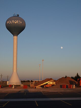
Wolfforth is a town located in Lubbock County, Texas, United States. It is a southwestern suburb of Lubbock. The population was 5,521 at the 2020 census.

<span class="mw-page-title-main">Matador, Texas</span> Town in Texas, United States

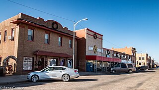
Matador is a town in and the county seat of Motley County, Texas, United States. Its population was 607 at the 2010 census. In 1891, it was established by and named for the Matador Ranch. It is located 95 miles (153 km) east of Lubbock, Texas.

References

  1. "Floyd County, Texas". United States Census Bureau . Retrieved January 30, 2022.
  2. "Find a County". National Association of Counties. Archived from the original on May 31, 2011. Retrieved June 7, 2011.
  3. "Texas: Individual County Chronologies". Texas Atlas of Historical County Boundaries. The Newberry Library. 2008. Archived from the original on April 12, 2017. Retrieved May 23, 2015.
  4. Gannett, Henry (1905). The Origin of Certain Place Names in the United States. Govt. Print. Off. pp.  127.
  5. "Matador Ranch," Historical marker, Texas Historical Commission, Motley County, Texas
  6. "2010 Census Gazetteer Files". United States Census Bureau. August 22, 2012. Retrieved April 26, 2015.
  7. "Decennial Census of Population and Housing by Decade". US Census Bureau.
  8. "Texas Almanac: Population History of Counties from 1850–2010" (PDF). Texas Almanac. Archived (PDF) from the original on October 9, 2022. Retrieved April 26, 2015.
  9. 1 2 "P2 HISPANIC OR LATINO, AND NOT HISPANIC OR LATINO BY RACE - 2010: DEC Redistricting Data (PL 94-171) - Floyd County, Texas". United States Census Bureau .
  10. 1 2 "P2 HISPANIC OR LATINO, AND NOT HISPANIC OR LATINO BY RACE - 2020: DEC Redistricting Data (PL 94-171) - Floyd County, Texas". United States Census Bureau .
  11. "U.S. Census website". United States Census Bureau . Retrieved May 14, 2011.
  12. "ON THE RECORD: All Ag, All Day celebrates 20 years". Floyd County Record. Retrieved November 8, 2021.
  13. "Floyd County's Orr Returns for 27th Scoreboard Season". Floyd County Record. Retrieved August 25, 2022.
  14. "State Rep. Springer announces district tour July 30". Lubbock Avalanche-Journal, July 16, 2013. Retrieved July 18, 2013.
  15. Leip, David. "Dave Leip's Atlas of U.S. Presidential Elections". uselectionatlas.org. Retrieved July 22, 2018.
  16. "2020 CENSUS - SCHOOL DISTRICT REFERENCE MAP: Floyd County, TX" (PDF). U.S. Census Bureau. Archived (PDF) from the original on October 9, 2022. Retrieved June 29, 2022. - list
  17. Texas Education Code, Sec. 130.198. SOUTH PLAINS COLLEGE DISTRICT SERVICE AREA.

34°04′N101°18′W / 34.07°N 101.30°W / 34.07; -101.30