Medina County, Texas

Last updated

Medina County
Medina county tx courthouse.jpg
The Medina County Courthouse in Hondo
Map of Texas highlighting Medina County.svg
Location within the U.S. state of Texas
Texas in United States.svg
Texas's location within the U.S.
Coordinates: 29°21′N99°07′W / 29.35°N 99.11°W / 29.35; -99.11
CountryFlag of the United States.svg United States
StateFlag of Texas.svg  Texas
Founded1848
Named for Medina River
Seat Hondo
Largest cityHondo
Area
  Total1,335 sq mi (3,460 km2)
  Land1,325 sq mi (3,430 km2)
  Water9.2 sq mi (24 km2)  0.7%
Population
 (2020)
  Total50,748
  Density38/sq mi (15/km2)
Time zone UTC−6 (Central)
  Summer (DST) UTC−5 (CDT)
Congressional district 23rd
Website www.medinacountytexas.org

Medina County is a county located in the U.S. state of Texas. As of the 2020 census, its population was 50,748. [1] Its county seat is Hondo. [2] The county is named for the Medina River. The extreme northern part of the county lies within the Edwards Plateau, which elevates into the Texas Hill Country. The Medina Dam, the fourth largest in the nation when completed in 1913, is listed on the National Register of Historic Places. [3] The irrigation project, creating Medina Lake, was built by 1500 skilled workers who worked in shifts operating 24 hours a day to complete the dam in two years. Medina County is part of the San Antonio, TX Metropolitan Statistical Area.

Contents

History

The county is named after the Medina River, which was named in 1689 after the Spanish cartographer Pedro de Medina by the Spanish explorer Alonso de Leon, the first European to encounter the river. [4] Because Pedro de Medina derived his surname from the Andalusian city of Medina-Sidonia, the name Medina comes from the Arabic for city.

The Texas Legislature formed Medina county on February 12, 1848, and enlarged it on February 1, 1850, using land taken from Bexar County. Castroville was the county seat, and the county erected the first permanent courthouse there in 1854. The county seat moved to Hondo in 1892, and a new courthouse was completed there in 1893. [5]

Geography

According to the U.S. Census Bureau, the county has a total area of 1,335 square miles (3,460 km2), of which 1,325 square miles (3,430 km2) is land and 9.2 square miles (24 km2) (0.7%) is water. [6]

Major highways

Adjacent counties

Demographics

Historical population
CensusPop.Note
1850 909
1860 1,838102.2%
1870 2,07813.1%
1880 4,492116.2%
1890 5,73027.6%
1900 7,78335.8%
1910 13,41572.4%
1920 11,679−12.9%
1930 13,98919.8%
1940 16,10615.1%
1950 17,0135.6%
1960 18,90411.1%
1970 20,2497.1%
1980 23,16414.4%
1990 27,31217.9%
2000 39,30443.9%
2010 46,00617.1%
2020 50,74810.3%
U.S. Decennial Census [7]
1850–2010 [8] 2010 [9] 2020 [10]
Medina County, Texas - Demographic Profile
(NH = Non-Hispanic)
Race / EthnicityPop 2010 [9] Pop 2020 [10] % 2010% 2020
White alone (NH)21,40822,32446.53%43.99%
Black or African American alone (NH)9131,2521.98%2.47%
Native American or Alaska Native alone (NH)1461580.32%0.31%
Asian alone (NH)2722150.59%0.42%
Pacific Islander alone (NH)24380.05%0.07%
Some Other Race alone (NH)281880.06%0.37%
Mixed Race/Multi-Racial (NH)3441,1180.75%2.20%
Hispanic or Latino (any race)22,87125,45549.71%50.16%
Total46,00650,748100.00%100.00%

Note: the US Census treats Hispanic/Latino as an ethnic category. This table excludes Latinos from the racial categories and assigns them to a separate category. Hispanics/Latinos can be of any race.

As of the census [11] of 2000, there were 39,304 people, 12,880 households, and 10,136 families residing in the county. The population density was 30 people per square mile (12 people/km2). There were 14,826 housing units at an average density of 11 units per square mile (4.2/km2). The racial makeup of the county was 79.38% White, 2.20% Black or African American, 0.68% Native American, 0.33% Asian, 0.05% Pacific Islander, 14.48% from other races, and 2.88% from two or more races. 45.47% of the population were Hispanic or Latino of any race.

There were 12,880 households, out of which 39.10% had children under the age of 18 living with them, 63.20% were married couples living together, 11.10% had a female householder with no husband present, and 21.30% were non-families. 18.20% of all households were made up of individuals, and 8.20% had someone living alone who was 65 years of age or older. The average household size was 2.91 and the average family size was 3.30.

In the county, the population was spread out, with 29.00% under the age of 18, 8.40% from 18 to 24, 28.70% from 25 to 44, 21.50% from 45 to 64, and 12.40% who were 65 years of age or older. The median age was 34 years. For every 100 females, there were 105.60 males. For every 100 females age 18 and over, there were 104.90 males.

The median income for a household in the county was $36,063, and the median income for a family was $40,288. Males had a median income of $27,045 versus $21,734 for females. The per capita income for the county was $15,210. About 12.00% of families and 15.40% of the population were below the poverty line, including 19.80% of those under age 18 and 15.60% of those age 65 or over.

Communities

Cities

Census-designated places

Unincorporated communities

Ghost towns

Education

Most of Medina County is served by the Hondo Independent School District. [12]

The designated community college is Southwest Texas Junior College. [13]

Politics

United States presidential election results for Medina County, Texas [14]
Year Republican Democratic Third party
No.%No.%No.%
2020 15,64269.04%6,77329.89%2421.07%
2016 12,08570.07%4,63426.87%5273.06%
2012 11,07969.03%4,78429.81%1861.16%
2008 10,48066.59%5,14732.71%1100.70%
2004 10,38970.07%4,32229.15%1150.78%
2000 8,59066.73%4,02531.27%2582.00%
1996 5,71055.03%3,88037.39%7877.58%
1992 4,91245.54%3,65033.84%2,22320.61%
1988 5,72257.05%4,22742.15%800.80%
1984 5,73765.17%3,05334.68%130.15%
1980 4,74260.12%3,03438.46%1121.42%
1976 3,25246.54%3,68152.68%550.79%
1972 4,05971.85%1,50726.68%831.47%
1968 2,05839.19%2,47147.06%72213.75%
1964 1,58331.71%3,40868.27%10.02%
1960 2,02846.43%2,32553.23%150.34%
1956 2,66863.51%1,51636.09%170.40%
1952 3,20463.52%1,84036.48%00.00%
1948 1,49242.39%1,87553.27%1534.35%
1944 1,60747.42%1,46943.35%3139.24%
1940 1,48045.83%1,74954.17%00.00%
1936 96931.97%2,05067.63%120.40%
1932 51516.96%2,51682.87%50.16%
1928 1,24346.94%1,40052.87%50.19%
1924 81635.81%98643.26%47720.93%
1920 77245.71%51930.73%39823.56%
1916 65045.11%75852.60%332.29%
1912 21918.85%64855.77%29525.39%

See also

Related Research Articles

<span class="mw-page-title-main">Wilson County, Texas</span> County in Texas, United States

Wilson County is a county located in the U.S. state of Texas. As of the 2020 census, its population was 49,753. Its county seat is Floresville. The county is named after James Charles Wilson. Wilson County is part of the San Antonio–New Braunfels, Texas, metropolitan statistical area.

<span class="mw-page-title-main">McMullen County, Texas</span> County in Texas, United States

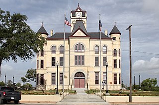
McMullen County is a county located in the U.S. state of Texas. As of the 2020 census, its population was 600, making it the fourth-least populous county in Texas. Its county seat is Tilden. The county was established from parts of Bexar County, Atascosa County, and Live Oak County in 1858 and later organized in 1877. It is named for John McMullen, founder of a colony in Texas. The McMullen County Courthouse was designed by the architect W.C. Stephenson, originally from Buffalo, New York. Stephenson also designed some 50 buildings in Beeville, including the Bee County Courthouse.

<span class="mw-page-title-main">Live Oak County, Texas</span> County in Texas, United States

Live Oak County is a county in the U.S. state of Texas. It was named for its native groves of live oak. George West is its county seat. Its population was 11,335 in the 2020 census.

<span class="mw-page-title-main">La Salle County, Texas</span> County in Texas, United States

La Salle County is a county in Texas. As of the 2020 census, its population was 6,664. Its county seat is Cotulla. The county was created in 1858 and later organized in 1880. It is named for René-Robert Cavelier, Sieur de La Salle, a 17th-century French explorer.

<span class="mw-page-title-main">Karnes County, Texas</span> County in Texas, United States

Karnes County is a county in the U.S. state of Texas. As of the 2020 census, the population was 14,710. Its county seat is Karnes City. The county is named for Henry Karnes, a soldier in the Texas Revolution. The former San Antonio and Aransas Pass Railway passed through Karnes County in its connection linking San Antonio with Corpus Christi.

<span class="mw-page-title-main">Hockley County, Texas</span> County in Texas, United States

Hockley County is a county located in the U.S. state of Texas. As of the 2020 census, its population was 21,537. Its county seat is Levelland. The county was created in 1876, but not organized until 1921. It is named for George Washington Hockley, a secretary of war of the Republic of Texas.

<span class="mw-page-title-main">Garza County, Texas</span> County in Texas, United States

Garza County is a county located in the U.S. state of Texas. As of the 2020 census, its population was 5,816, of which most of the population were residing in its county seat, and only incorporated municipality, Post. The county was created in 1876 and later organized in 1907. Garza is named for a pioneer Bexar County family, as it was once a part of that county.

<span class="mw-page-title-main">Frio County, Texas</span> County in Texas, United States

Frio County is a county located in the U.S. state of Texas. As of the 2020 census, its population was 18,385. The county seat is Pearsall. The county was created in 1858 and later organized in 1871. Frio is named for the Frio River, whose name is Spanish for "cold".

<span class="mw-page-title-main">Cameron County, Texas</span> County in Texas, United States

Cameron County, officially the County of Cameron, is the southernmost county in the U.S. state of Texas. As of the 2020 census, its population was 421,017. Its county seat is Brownsville.

<span class="mw-page-title-main">Bexar County, Texas</span> County in Texas, United States

Bexar County is a county in the U.S. state of Texas. It is in South Texas and its county seat is San Antonio.

<span class="mw-page-title-main">Bandera County, Texas</span> County in Texas, United States

Bandera County is a county in the U.S. state of Texas. It is located in the Hill Country and its county seat is Bandera. Bandera county was settled be German and Polish emigrants in the mid 1800s. Many residents are descendants of those same emigrants.

<span class="mw-page-title-main">Atascosa County, Texas</span> County in Texas, United States

Atascosa County is a county located in the U.S. state of Texas. It is in South Texas and its county seat is Jourdanton.

<span class="mw-page-title-main">Cross Mountain, Texas</span> Census-designated place in Texas, United States

Cross Mountain is a census-designated place (CDP) in Bexar County, Texas, United States. The population was 3,944 at the 2020 census, an increase over the figure of 3,124 tabulated in 2010. It is part of the San Antonio Metropolitan Statistical Area.

<span class="mw-page-title-main">Scenic Oaks, Texas</span> Census-designated place in Texas, United States

Scenic Oaks is a census-designated place (CDP) in Bexar County, Texas, United States. It is part of the San Antonio Metropolitan Statistical Area. The population was 10,458 at the 2010 census, up from 4,957 at the 2010 census.

<span class="mw-page-title-main">Somerset, Texas</span> City in Texas, United States

Somerset is a city located in Bexar County, Texas, United States. It is located less than 20 miles south of Downtown San Antonio and is part of the San Antonio–New Braunfels metropolitan area. The population was 1,756 at the 2020 census.

<span class="mw-page-title-main">Rio Hondo, Texas</span> City in Texas, United States

Rio Hondo is a city in Cameron County, Texas, United States. The population was 2,356 at the 2010 census. It may be included as part of the Brownsville–Harlingen–Raymondville and the Matamoros–Brownsville metropolitan areas.

<span class="mw-page-title-main">Castroville, Texas</span> City in Texas, United States

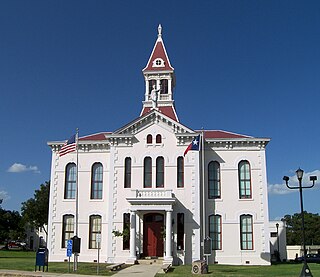
Castroville is a city in Medina County, Texas, United States. Its population was 2,680 at the 2010 census. Prior to 1893, Castroville was the first county seat of Medina County. Castroville was founded by Alsatian-Texans, who came to Texas during the German emigration period of the mid-1800s. Most Alsatians who came to Castroville spoke Alsatian. The Alsatian culture and language are still kept alive by the residents of Castroville.

<span class="mw-page-title-main">Hondo, Texas</span> City in Texas, United States

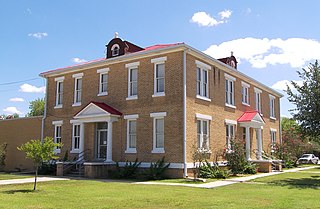
Hondo is a city in and the county seat of Medina County, Texas, United States. According to the 2010 Census, the population was 8,803. It is part of the San Antonio Metropolitan Statistical Area.

<span class="mw-page-title-main">Lytle, Texas</span> City in Atascosa, Bexar, and Medina counties in Texas, U.S.

Lytle is a city in Atascosa, Bexar, and Medina counties in the U.S. state of Texas. The population was 2,492 at the 2010 census. It is part of the San Antonio Metropolitan Statistical Area.

<span class="mw-page-title-main">Greater San Antonio</span> Metropolitan Area in Texas, United States

Greater San Antonio, officially designated San Antonio–New Braunfels, is an eight-county metropolitan area in the U.S. state of Texas defined by the Office of Management and Budget (OMB). The metropolitan area straddles South Texas and Central Texas and is on the southwestern corner of the Texas Triangle. The official 2020 U.S. census showed the metropolitan area's population at 2,558,143—up from a reported 1,711,103 in 2000—making it the 24th largest metropolitan area in the United States. Downtown Austin and Downtown San Antonio are approximately 80 miles (129 km) apart, and both fall along the Interstate 35 corridor. This combined metropolitan region of San Antonio–Austin has approximately 5 million people.

References

  1. "Medina County, Texas". United States Census Bureau . Retrieved January 30, 2022.
  2. "Find a County". National Association of Counties. Archived from the original on May 31, 2011. Retrieved June 7, 2011.
  3. Ruben E. Ochoa, "Medina County", Handbook of Texas Online, accessed August 3, 2010
  4. Norris, Lola Orellano. GENERAL ALONSO DE LEÓN'S EXPEDITION DIARIES INTO TEXAS (1686-1690): A LINGUISTIC ANALYSIS OF THE SPANISH MANUSCRIPTS WITH SEMIPALEOGRAPHIC TRANSCRIPTIONS AND ENGLISH TRANSLATIONS (PDF). pp. 274, 277.
  5. Ochoa, Ruben E. "Medina County". Handbook of Texas Online. Texas State Historical Association. Retrieved March 18, 2018.
  6. "2010 Census Gazetteer Files". United States Census Bureau. August 22, 2012. Retrieved May 4, 2015.
  7. "Decennial Census by Decade". US Census Bureau.
  8. "Texas Almanac: Population History of Counties from 1850–2010" (PDF). Texas Almanac. Archived (PDF) from the original on October 9, 2022. Retrieved May 4, 2015.
  9. 1 2 "P2 HISPANIC OR LATINO, AND NOT HISPANIC OR LATINO BY RACE - 2010: DEC Redistricting Data (PL 94-171) - Medina County, Texas". United States Census Bureau .
  10. 1 2 "P2 HISPANIC OR LATINO, AND NOT HISPANIC OR LATINO BY RACE - 2020: DEC Redistricting Data (PL 94-171) - Medina County, Texas". United States Census Bureau .
  11. "U.S. Census website". United States Census Bureau . Retrieved May 14, 2011.
  12. "2020 CENSUS - SCHOOL DISTRICT REFERENCE MAP: Medina County, TX" (PDF). U.S. Census Bureau. Archived (PDF) from the original on October 9, 2022. Retrieved June 29, 2022. - Text list
  13. Texas Education Code: Sec. 130.200. SOUTHWEST TEXAS JUNIOR COLLEGE DISTRICT SERVICE AREA.
  14. Leip, David. "Dave Leip's Atlas of U.S. Presidential Elections". uselectionatlas.org. Retrieved July 27, 2018.

Further reading

Commons-logo.svg Media related to Medina County, Texas at Wikimedia Commons

29°21′N99°07′W / 29.35°N 99.11°W / 29.35; -99.11