Grimes County, Texas

Last updated

Grimes County
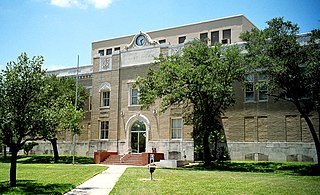
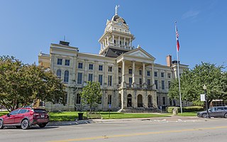
Grimes County Courthouse, Anderson, Texas 1803091126 (40711037292).jpg
The Grimes County Courthouse in Anderson
Map of Texas highlighting Grimes County.svg
Location within the U.S. state of Texas
Texas in United States.svg
Texas's location within the U.S.
Coordinates: 30°33′N95°59′W / 30.55°N 95.98°W / 30.55; -95.98
CountryFlag of the United States.svg United States
StateFlag of Texas.svg  Texas
Founded1846
Named for Jesse Grimes
Seat Anderson
Largest city Navasota
Area
  Total802 sq mi (2,080 km2)
  Land787 sq mi (2,040 km2)
  Water14 sq mi (40 km2)  1.8%
Population
 (2020)
  Total29,268
  Density36/sq mi (14/km2)
Time zone UTC−6 (Central)
  Summer (DST) UTC−5 (CDT)
Congressional district 10th
Website www.co.grimes.tx.us

Grimes County is a county located in southeastern Texas, United States. As of the 2020 census, its population was 29,268. [1] The seat of the county is Anderson. [2] The county was formed from Montgomery County in 1846. [3] It is named for Jesse Grimes, a signer of the Texas Declaration of Independence and early European-American settler of the county. [4]

Contents

The Navasota and Brazos Rivers form the western boundary of the county. Eastern areas of the county are part of the watershed of the San Jacinto River.

History

In the historic period, French and Spanish explorers encountered the Bidai Indians, who were mentioned in Spanish records from 1691. Like other tribes, they suffered high fatalities from new infectious diseases caught from the Spanish and joined with the remnants of other Native American people later in the historic period.

The area saw very little settlement by Europeans or creole Spanish during the century of Spanish colonial rule. However, after Mexico gained its independence, it invited settlers from the United States to come to eastern Texas. They were allowed them to practice their own religion, as long as they swore loyalty to the Mexican government.

A few historic buildings in Anderson, such as the Fanthorp Inn, date from this period, as well as some from the Republic of Texas and the early statehood years. For this reason, the town and nearby area have been designated the "Anderson Historic District", which is listed on the National Register of Historic Places.

Anglo-American migration to what became Grimes County began in the 1820s, when it was part of Mexico. Early settlers were primarily from the South, especially Alabama, and many brought enslaved African Americans with them to work the land. The first cotton gin in Texas was built by Jared E. Groce, who arrived with 90 slaves and developed a cotton plantation near today's Hempstead, Texas. [5]

Texas achieved its independence in 1836, and settlers arrived in greater numbers from the United States. The fertile lowlands were initially used for cotton plantations, especially in the late antebellum period. [5]

Grimes County was organized in 1846, one year after the Republic of Texas agreed to be annexed by the United States. From 1850 to the Civil War, the White population steadily increased, since the newcomers continued to bring slaves, the African American population increased even faster. Planters continued to grow cotton and corn as commodity crops. By 1860, 4,852 White inhabitants were in the county, plus 5,468 slaves, who made up 53% of the population. The White population had doubled in the preceding decade, while the slave population had tripled. Grimes had a total of 505 slaveholding families in 1860, with 77 owning 20 slaves or more, that number considered the minimum for major planters. It was one of 17 counties in the state where slaveholders held on average, more than 10 slaves each. [5]

In such conditions, Whites were anxious after the emancipation of slaves, and also struggled with adapting to a free labor market. White violence rose after the war, and the Ku Klux Klan established a local chapter in 1868 to assert dominance. Federal troops were stationed in the area and the Freedman's Bureau had an office in the county. They were not successful in protecting freedmen, but the Bureau established schools in the area. [5]

Determined to crush Populist efforts and alliances with Republicans that resulted in victories in 1896 and 1898, White Democrats formed what became the White Man's Union, a secret, oath-bound organization that violently took over elections in 1900, after killing several Black Populist leaders. It selected all county officials until 1958. [5]

White violence continued after Reconstruction and into the early 20th century, when Whites committed 9 lynchings of Blacks in the county, part of racial terrorism to suppress the freedmen. Grimes and Freestone Counties had the same number of lynchings in this period, ranking as the fifth-highest totals in a state where lynchings were widespread and conducted in many counties. [6] The economy declined in the late 19th century, increasing social tensions.

In 1859, the Houston and Texas Central extended its line into the county. Anderson, the county seat, rejected it and was bypassed for Navasota, which soon surpassed it in size. [5] Anderson finally got a railroad in the early 1900s, but never caught up with Navasota. In the late 19th and 20th centuries, the Burlington Northern Santa Fe and the Union Pacific became the major railroads in the county.

In response to the violence and takeover by the White Man's Union, African Americans began to leave the county in large numbers. The population of the county declined markedly from 1900 to 1920, and after 1930 to 1980. These were periods of the Great Migration, as African Americans left Texas and other parts of the South to leave behind the oppression of Jim Crow and disenfranchisement, and seek better work. From 1940 on, many migrated to the West Coast for jobs in the expanding defense industry. Rural Whites also left the South for industrial cities.

The county remained mostly rural and agricultural until the late 20th century, which contributed to its continuing population losses. Timber harvesting and processing were part of early industry in the 20th century, but stock raising and dairy farms contributed more to the overall agricultural economy in the later 20th century, making up 93% of its revenues. In addition, crops have become more diversified. [5] Railroad restructuring in the late 20th century resulted in mergers among some lines. In the 21st century, State Highway 90 is the major north–south thoroughfare, and State Highways 30 and 105 run east–west. With some new manufacturing, population began to increase since the late 1970s. In 2014, the census estimated 27,172 people living in Grimes County. About 59.5% were Anglo, 22.6% were Hispanic, and 16.5% were African American. [5]

Geography

According to the U.S. Census Bureau, the county has a total area of 802 square miles (2,080 km2), of which 14 square miles (36 km2) (1.8%) is covered by water. [7]

Major highways

Adjacent counties

Demographics

Historical population
CensusPop.Note
1850 4,008
1860 10,307157.2%
1870 13,21828.2%
1880 18,60340.7%
1890 21,31214.6%
1900 26,10622.5%
1910 21,205−18.8%
1920 23,1018.9%
1930 22,642−2.0%
1940 21,960−3.0%
1950 15,135−31.1%
1960 12,709−16.0%
1970 11,855−6.7%
1980 13,58014.6%
1990 18,82838.6%
2000 23,55225.1%
2010 26,60413.0%
2020 29,26810.0%
U.S. Decennial Census [8]
1850–2010 [9] 2010 [10] 2020 [11]
Grimes County, Texas - Demographic Profile
(NH = Non-Hispanic)
Race / EthnicityPop 2010 [10] Pop 2020 [11] % 2010% 2020
White alone (NH)16,13316,91060.64%57.78%
Black or African American alone (NH)4,3483,82416.34%13.07%
Native American or Alaska Native alone (NH)82850.31%0.29%
Asian alone (NH)611020.23%0.35%
Pacific Islander alone (NH)780.03%0.03%
Some other race alone (NH)16840.06%0.29%
Mixed race/multiracial (NH)3058941.15%3.05%
Hispanic or Latino (any race)5,6527,36121.24%25.15%
Total26,60429,268100.00%100.00%

Note: the US Census treats Hispanic/Latino as an ethnic category. This table excludes Latinos from the racial categories and assigns them to a separate category. Hispanics/Latinos can be of any race.

As of the 2000 census, [12] 23,552 people, 7,753 households, and 5,628 families were residing in the county. The population density was 30 people per square mile (12 people/km2). The 9,490 housing units had an average density of 12 units per square mile (4.6 units/km2). The racial makeup of the county was 71.79% White, 19.96% African American, 0.32% Native American, 0.30% Asian, 5.98% from other races, and 1.65% from two or more races. About 16.08% of the population were Hispanics or Latinos of any race.

Christianity is the primary religion in the county and Hinduism is the second. [13]

Of the 7,753 households, 34.6% had children under 18 living with them, 55.4% were married couples living together, 12.6% had a female householder with no husband present, and 27.4% were not families. About 23.8% of all households were made up of individuals, and 11.2% had someone living alone who was 65 or older. The average household size was 2.69, and the average family size was 3.18.

In the county, the age distribution was 24.8% under 18, 7.7% from 18 to 24, 29.8% from 25 to 44, 24.0% from 45 to 64, and 13.7% who were 65 or older. The median age was 38 years. For every 100 females, there were 117.50 males. For every 100 females 18 and over, there were 124.00 males.

The median income for a household in the county was $32,280, and for a family was $38,008. Males had a median income of $30,138 versus $21,747 for females. The per capita income for the county was $14,368. About 13.8% of families and 16.6% of the population were below the poverty line, including 20.4% of those under 18 and 18.1% of those 65 or over.

Government and infrastructure

County government

The Grimes County Commissioners Court is the primary decision-making body for the county government. The court is composed of the four county commissioners and is headed by the county judge, who oversees the day-to-day operation of the government. In addition to their policy-making duties, the four commissioners are responsible for road and bridge projects within their precincts. [14] The current county judge, Joe Fauth III, entered office in 2017.

The Grimes County sheriff is the top law enforcement official in the county. The sheriff holds primary law enforcement responsibility over the county's unincorporated areas, and several cities covered under various interlocal agreements. The current sheriff, Donald G. Sowell, has held the office since 1998.

Other elected county officials include:

Texas Department of Criminal Justice facilities

The Texas Department of Criminal Justice operates the O.L. Luther Unit and the Wallace Pack Unit in an unincorporated area in Grimes County. [15] In addition, the Pack Warehouse is located in an unincorporated area near the Pack Unit. [16]

United States presidential election results for Grimes County, Texas [17]
Year Republican Democratic Third party
No.%No.%No.%
2020 9,43275.98%2,83322.82%1491.20%
2016 7,06574.11%2,19423.01%2742.87%
2012 6,14171.40%2,33927.19%1211.41%
2008 5,56266.83%2,70432.49%560.67%
2004 5,26365.54%2,71333.79%540.67%
2000 4,19761.70%2,45036.02%1552.28%
1996 2,56444.97%2,58445.33%5539.70%
1992 2,40238.64%2,59441.72%1,22119.64%
1988 2,82050.52%2,73549.00%270.48%
1984 3,36558.50%2,37041.20%170.30%
1980 2,08745.35%2,44053.02%751.63%
1976 1,47335.51%2,65664.03%190.46%
1972 2,24366.44%1,11633.06%170.50%
1968 1,07630.52%1,47341.79%97627.69%
1964 1,01431.23%2,22968.65%40.12%
1960 1,05337.90%1,71361.66%120.43%
1956 1,28153.96%1,07945.45%140.59%
1952 1,55753.32%1,36246.64%10.03%
1948 33619.53%90152.38%48328.08%
1944 1376.95%1,55979.14%27413.91%
1940 2989.32%2,89990.62%20.06%
1936 1366.84%1,85193.06%20.10%
1932 1536.88%2,06592.89%50.22%
1928 70137.37%1,17562.63%00.00%
1924 1777.55%2,13691.09%321.36%
1920 21414.77%1,02770.88%20814.35%
1916 1088.69%1,10889.14%272.17%
1912 353.33%94189.45%767.22%

Communities

Cities

Census-designated places

Unincorporated communities

Education

School districts:

Blinn College is the designated community college for all of the county. [18]

Notable residents

See also

Related Research Articles

<span class="mw-page-title-main">Montgomery County, Texas</span> County in Texas, United States

Montgomery County is a county in the U.S. state of Texas. As of the 2020 U.S. census, the county had a population of 620,443. The county seat is Conroe. The county was created by an act of the Congress of the Republic of Texas on December 14, 1837, and is named for the town of Montgomery. Between 2000 and 2010, its population grew by 55%, the 24th-fastest rate of growth of any county in the United States. Between 2010 and 2020, its population grew by 36%. According to the U.S. Census Bureau, the estimated population is 711,354 as of July 1, 2023.

<span class="mw-page-title-main">Wharton County, Texas</span> County in Texas, United States

Wharton County is a county located in the U.S. state of Texas. As of the 2020 census, its population was 41,570. Its county seat is Wharton. The county was named for brothers William Harris Wharton and John Austin Wharton.

<span class="mw-page-title-main">Washington County, Texas</span> County in Texas, United States

Washington County is a county in Texas. As of the 2020 census, the population was 35,805. Its county seat is Brenham, which is located along U.S. Highway 290, 72 miles northwest of Houston. The county was created in 1835 as a municipality of Mexico and organized as a county in 1837. It is named for George Washington, the first president of the United States.

<span class="mw-page-title-main">Walker County, Texas</span> County in Texas, United States

Walker County is a county located in the east central section of the U.S. state of Texas. As of the 2020 census, its population was 76,400. Its county seat is Huntsville. Initially, Walker County was named for Robert J. Walker, a legislator from Mississippi who introduced into the United States Congress the resolution to annex Texas. Walker later supported the U.S. during its Civil War and earned some enmity for it. In order to keep the county's name, the state renamed it for Samuel H. Walker, a Texas Ranger and soldier in the United States Army.

<span class="mw-page-title-main">San Patricio County, Texas</span> County in Texas, United States

San Patricio County is located in the U.S. state of Texas. As of the 2020 census, its population was 68,755. Its county seat is Sinton. San Patricio County is part of the Corpus Christi metropolitan statistical area.

<span class="mw-page-title-main">Sabine County, Texas</span> County in the United States

Sabine County is a county located on the central eastern border of the U.S. state of Texas. As of the 2020 census, its population was 9,894. The county was organized on December 14, 1837, and named for the Sabine River, which forms its eastern border.

<span class="mw-page-title-main">Navarro County, Texas</span> County in Texas, United States

Navarro County is a county in the U.S. state of Texas. As of the 2020 census, the population was 52,624. Its county seat is Corsicana. The county is named for José Antonio Navarro, a Tejano leader in the Texas Revolution who signed the Texas Declaration of Independence.

<span class="mw-page-title-main">Marion County, Texas</span> County in Texas, United States

Marion County is a county located in the U.S. state of Texas. As of the 2020 census, its population was 9,725. Its county seat is Jefferson. Marion County is in East Texas and is named for Francis Marion, the Revolutionary War general from South Carolina who was nicknamed the "Swamp Fox".

<span class="mw-page-title-main">Madison County, Texas</span> County in Texas, United States

Madison County is a county located in the U.S. state of Texas. As of the 2020 census, its population was 13,455. Its seat is Madisonville. The county was created in 1853 and organized the next year. It is named for James Madison, the fourth President of the United States. In 1852, Hillary Mercer Crabb was elected to serve the unexpired term of State Representative F. L. Hatch. Among Crabb's accomplishments as a legislator was the introduction of a bill to create Madison County.

<span class="mw-page-title-main">Houston County, Texas</span> County in Texas, United States

Houston County is a county located in the U.S. state of Texas. As of the 2020 census, its population was 22,066. Its county seat is Crockett. Houston County was one of 46 entirely dry counties in the state of Texas, until voters in a November 2007 special election legalized the sale of alcohol in the county.

<span class="mw-page-title-main">Henderson County, Texas</span> County in Texas, United States

Henderson County is a county in the U.S. state of Texas. As of the 2020 census, its population was 82,150. The county seat is Athens. The county is named in honor of James Pinckney Henderson, the first attorney general of the Republic of Texas, and secretary of state for the republic. He later served as the first governor of Texas. Henderson County was established in 1846, the year after Texas gained statehood. Its first town was Buffalo, laid out in 1847. Henderson County comprises the Athens micropolitan statistical area, which is also included in the Dallas-Fort Worth combined statistical area.

<span class="mw-page-title-main">Harrison County, Texas</span> County in Texas, United States

Harrison County is a county on the eastern border of the U.S. state of Texas. As of the 2020 United States census, its population was 68,839. The county seat is Marshall. The county was created in 1839 and organized in 1842. It is named for Jonas Harrison, a lawyer and Texas revolutionary.

<span class="mw-page-title-main">Freestone County, Texas</span> County in Texas, United States

Freestone County is a county in the east-central part of the U.S. state of Texas. As of the 2020 census, its population was 19,435. Its county seat is Fairfield. The county was created in 1850 and organized the next year.

<span class="mw-page-title-main">Brazos County, Texas</span> County in Texas, United States

Brazos County is a county in the U.S. state of Texas. As of the 2020 census, its population was 233,849. The county seat is Bryan. Along with Brazoria County, the county is named for the Brazos River, which forms its western border. The county was formed in 1841 and organized in 1843.

<span class="mw-page-title-main">Bell County, Texas</span> County in Texas, United States

Bell County is a county in the U.S. state of Texas. It is in Central Texas and its county seat is Belton.

<span class="mw-page-title-main">Angelina County, Texas</span> County in Texas, United States

Angelina County is a county located in the U.S. state of Texas. It is in East Texas and its county seat is Lufkin.

<span class="mw-page-title-main">Anderson County, Texas</span> County in Texas, United States

Anderson County is a county in the U.S. state of Texas. Located within East Texas, its county seat is Palestine. As of the 2020 United States census, the population of Anderson County was 57,922. Anderson County comprises the Palestine micropolitan statistical area. Anderson County was organized in 1846, and was named after Kenneth Lewis Anderson (1805-1845), the last vice president of the Republic of Texas.

<span class="mw-page-title-main">Anderson, Texas</span> City in Texas, United States

Anderson is a city and county seat of Grimes County, Texas, United States. The population was 193 as of the 2020 census. The town and its surroundings are listed on the National Register of Historic Places as the Anderson Historic District.

<span class="mw-page-title-main">Navasota, Texas</span> City in Texas, United States

Navasota is a city primarily in Grimes County, Texas, United States. The population was 7,643 at the 2020 census. In 2005, the Texas Legislature designated Navasota as the "Blues Capital of Texas" in honor of the late Mance Lipscomb, a Navasota native and blues musician. Technically, a sliver of Navasota is in Brazos County, which is part of the Bryan-College Station Metropolitan area.

<span class="mw-page-title-main">Bedias, Texas</span> City in Texas, United States

Bedias is a city in Grimes County, Texas, United States at the intersection of State Highway 90 and Farm Roads 1696 and 2620, 30 miles (48 km) northeast of Navasota in northeastern Grimes County. It was incorporated as a city in 2003 and had a population of 361 at the 2020 census.

References

  1. "Grimes County, Texas". United States Census Bureau . Retrieved January 30, 2022.
  2. "Find a County". National Association of Counties. Archived from the original on May 31, 2011. Retrieved June 7, 2011.
  3. "Grimes County". The Handbook of Texas Online. June 15, 2010. Retrieved May 12, 2015.
  4. "Grimes County - Named After Jesse Grimes". Stopping Points Historical Markers & Points of Interest. Retrieved July 24, 2018.
  5. 1 2 3 4 5 6 7 8 Grimes County from the Handbook of Texas Online
  6. Lynching in America/Summary by County (3rd edition) Archived October 23, 2017, at the Wayback Machine , p. 9, Equal Justice Initiative, 2017, Montgomery, Alabama
  7. "2010 Census Gazetteer Files". United States Census Bureau. August 22, 2012. Retrieved April 27, 2015.
  8. "Decennial Census of Population and Housing by Decades". US Census Bureau.
  9. "Texas Almanac: Population History of Counties from 1850–2010" (PDF). Texas Almanac. Archived (PDF) from the original on October 9, 2022. Retrieved April 27, 2015.
  10. 1 2 "P2 HISPANIC OR LATINO, AND NOT HISPANIC OR LATINO BY RACE - 2010: DEC Redistricting Data (PL 94-171) - Grimes County, Texas". United States Census Bureau .
  11. 1 2 "P2 HISPANIC OR LATINO, AND NOT HISPANIC OR LATINO BY RACE - 2020: DEC Redistricting Data (PL 94-171) - Grimes County, Texas". United States Census Bureau .
  12. "U.S. Census website". United States Census Bureau . Retrieved May 14, 2011.
  13. Wilson, Reid. The second-largest religion in each state, Washington Post , June 4, 2014.
  14. "Texas County Commissioner". Texas Association of Counties. Retrieved March 29, 2019.
  15. "Pack Unit Archived 2010-07-25 at the Wayback Machine ." Texas Department of Criminal Justice. Retrieved on May 22, 2010.
  16. "Pack Warehouse Archived 2010-07-12 at the Wayback Machine ." Texas Department of Criminal Justice. Retrieved on May 22, 2010.
  17. Leip, David. "Dave Leip's Atlas of U.S. Presidential Elections". uselectionatlas.org. Retrieved July 24, 2018.
  18. Texas Education Code Sec. 130.168. BLINN JUNIOR COLLEGE DISTRICT SERVICE AREA.
  19. "Chuck Norris and wife open new bottled water production facility in Navasota". KBTX-TV. January 10, 2017. Retrieved November 17, 2017.

30°33′N95°59′W / 30.55°N 95.98°W / 30.55; -95.98