Milam County | |
---|---|
Coordinates: 30°47′N96°59′W / 30.79°N 96.98°W | |
Country | United States |
State | Texas |
Founded | 1837 |
Named for | Benjamin Rush Milam |
Seat | Cameron |
Largest city | Rockdale |
Area | |
• Total | 1,022 sq mi (2,650 km2) |
• Land | 1,017 sq mi (2,630 km2) |
• Water | 4.8 sq mi (12 km2) 0.5% |
Population (2020) | |
• Total | 24,754 |
• Density | 24/sq mi (9.4/km2) |
Time zone | UTC−6 (Central) |
• Summer (DST) | UTC−5 (CDT) |
Congressional district | 17th |
Website | www |
Milam County is a county located in the U.S. state of Texas. As of the 2020 census, its population was 24,754. [1] The county seat is Cameron. [2] The county was created in 1834 as a municipality in Mexico and organized as a county in 1837. [3] [4] Milam County is named for Benjamin Rush Milam, an early settler and a soldier in the Texas Revolution. [5]
According to the U.S. Census Bureau, the county has a total area of 1,022 square miles (2,650 km2), of which 1,017 sq mi (2,630 km2) are land and 4.8 sq mi (12 km2) (0.5%) are covered by water. [6]
Census | Pop. | Note | %± |
---|---|---|---|
1850 | 2,907 | — | |
1860 | 5,175 | 78.0% | |
1870 | 8,984 | 73.6% | |
1880 | 18,659 | 107.7% | |
1890 | 24,773 | 32.8% | |
1900 | 39,666 | 60.1% | |
1910 | 36,780 | −7.3% | |
1920 | 38,104 | 3.6% | |
1930 | 37,915 | −0.5% | |
1940 | 33,120 | −12.6% | |
1950 | 23,585 | −28.8% | |
1960 | 22,263 | −5.6% | |
1970 | 20,028 | −10.0% | |
1980 | 22,732 | 13.5% | |
1990 | 22,946 | 0.9% | |
2000 | 24,238 | 5.6% | |
2010 | 24,757 | 2.1% | |
2020 | 24,754 | 0.0% |
Race / Ethnicity | Pop 2010 [7] | Pop 2020 [8] | % 2010 | % 2020 |
---|---|---|---|---|
White alone (NH) | 16,216 | 15,367 | 65.50% | 62.08% |
Black or African American alone (NH) | 2,380 | 2,097 | 9.61% | 8.47% |
Native American or Alaska Native alone (NH) | 76 | 67 | 0.31% | 0.27% |
Asian alone (NH) | 95 | 111 | 0.38% | 0.45% |
Pacific Islander alone (NH) | 0 | 11 | 0.00% | 0.04% |
Some Other Race alone (NH) | 10 | 84 | 0.04% | 0.34% |
Mixed Race/Multi-Racial (NH) | 200 | 753 | 0.81% | 3.04% |
Hispanic or Latino (any race) | 5,780 | 6,264 | 23.35% | 25.31% |
Total | 24,757 | 24,754 | 100.00% | 100.00% |
Note: the US Census treats Hispanic/Latino as an ethnic category. This table excludes Latinos from the racial categories and assigns them to a separate category. Hispanics/Latinos can be of any race.
As of the census [9] of 2000, 24,238 people, 9,199 households, and 6,595 families were residing in the county. The population density was 24/sq mi (9.3/km2). The 10,866 housing units averaged 11/sq mi (4.2/km2). The racial makeup of the county was 78.89% White, 11.05% African American, 0.50% Native American, 0.22% Asian, 7.71% from other races, and 1.63% from two or more races. About 18.63% of the population were Hispanics or Latinos of any race. By ancestry, 16.7% were of American, 16.1% German, 7.2% English, and 6.8% Irish according to Census 2000.
Of the 9,199 households, 32.40% had children under the age of 18 living with them, 56.50% were married couples living together, 11.30% had a female householder with no husband present, and 28.30% were not families. About 25.90% were single-person households, and 14.10% had someone living alone who was 65 or older. The average household size was 2.59, and the average family size was 3.11.
In the county, the age distribution was 27.50% under 18, 7.70% from 18 to 24, 24.70% from 25 to 44, 22.90% from 45 to 64, and 17.20% who were 65 or older. The median age was 38 years. For every 100 females, there were 96.10 males. For every 100 females age 18 and over, there were 90.60 males.
The median income for a household in the county was $33,186, and for a family was $40,431. Males had a median income of $30,149 versus $20,594 for females. The per capita income for the county was $16,920. About 12.20% of families and 15.90% of the population were below the poverty line, including 21.80% of those under age 18 and 15.30% of those age 65 or over.
Six independent school districts are present in Milam County:
Four additional districts extend into parts of Milam County, but are based in neighboring counties: Bartlett, Caldwell, Holland, and Rosebud-Lott.
St. Paul Lutheran School St. Paul Lutheran Church and School, Thorndale in Thorndale, a private institution, serves students from prekindergarten through grade 8.
Temple Junior College District is the designated community college for county residents in Bartlett, Buckholts, Cameron, Rockdale, Rosebud-Lott, and Thorndale ISDs. Blinn College is the designated community college for county residents in Gause, Lexington, and Milano ISDs. [10]
Year | Republican | Democratic | Third party | |||
---|---|---|---|---|---|---|
No. | % | No. | % | No. | % | |
2020 | 7,984 | 75.48% | 2,496 | 23.60% | 98 | 0.93% |
2016 | 6,364 | 73.45% | 2,051 | 23.67% | 249 | 2.87% |
2012 | 5,481 | 66.60% | 2,636 | 32.03% | 113 | 1.37% |
2008 | 5,217 | 62.43% | 3,044 | 36.42% | 96 | 1.15% |
2004 | 5,291 | 60.24% | 3,445 | 39.22% | 47 | 0.54% |
2000 | 4,706 | 56.91% | 3,429 | 41.47% | 134 | 1.62% |
1996 | 3,019 | 39.90% | 3,869 | 51.13% | 679 | 8.97% |
1992 | 2,414 | 32.32% | 3,542 | 47.43% | 1,512 | 20.25% |
1988 | 3,512 | 41.83% | 4,865 | 57.94% | 19 | 0.23% |
1984 | 4,384 | 53.86% | 3,734 | 45.87% | 22 | 0.27% |
1980 | 3,251 | 42.62% | 4,230 | 55.46% | 146 | 1.91% |
1976 | 2,404 | 32.86% | 4,871 | 66.59% | 40 | 0.55% |
1972 | 3,554 | 62.14% | 2,159 | 37.75% | 6 | 0.10% |
1968 | 1,614 | 25.18% | 3,269 | 51.01% | 1,526 | 23.81% |
1964 | 1,334 | 23.37% | 4,368 | 76.51% | 7 | 0.12% |
1960 | 1,898 | 34.16% | 3,640 | 65.51% | 18 | 0.32% |
1956 | 2,486 | 45.48% | 2,969 | 54.32% | 11 | 0.20% |
1952 | 2,539 | 43.94% | 3,227 | 55.85% | 12 | 0.21% |
1948 | 646 | 15.05% | 3,261 | 75.98% | 385 | 8.97% |
1944 | 623 | 12.53% | 3,537 | 71.11% | 814 | 16.37% |
1940 | 1,110 | 21.31% | 4,083 | 78.38% | 16 | 0.31% |
1936 | 288 | 6.57% | 4,077 | 93.02% | 18 | 0.41% |
1932 | 264 | 5.32% | 4,676 | 94.22% | 23 | 0.46% |
1928 | 1,270 | 30.86% | 2,842 | 69.05% | 4 | 0.10% |
1924 | 930 | 14.68% | 5,087 | 80.31% | 317 | 5.00% |
1920 | 371 | 7.68% | 2,598 | 53.81% | 1,859 | 38.50% |
1916 | 576 | 19.15% | 2,198 | 73.07% | 234 | 7.78% |
1912 | 244 | 8.75% | 1,939 | 69.57% | 604 | 21.67% |
Wise County is a county in the U.S. state of Texas. As of the 2020 census, its population was 68,632. Its county seat is Decatur. Wise County is part of the Dallas–Fort Worth–Arlington metropolitan statistical area. Its Wise Eyes crime-watch program, eventually adopted by mostly rural counties in several states, was started in 1993 by then-Sheriff Phil Ryan.
Wilbarger County is a county located in the North Texas region of the U.S. state of Texas. As of the 2020 census, the population was 12,887. The county seat is Vernon. The county was created in 1858 and later organized in 1881. Wilbarger is named for Josiah Pugh Wilbarger and Mathias Wilbarger, two early settlers.
Terry County is a county located in the U.S. state of Texas. As of the 2020 census, its population was 11,831. Its county seat is Brownfield. The county was demarked in 1876 and organized in 1904. It is named for Benjamin Franklin Terry, a colonel in the Confederate Army. Terry County was one of 46 dry counties in the state of Texas, but is now a moist county. Terry County is one of the most productive pumpkin producing counties in the United States.
Sabine County is a county located on the central eastern border of the U.S. state of Texas. As of the 2020 census, its population was 9,894. The county was organized on December 14, 1837, and named for the Sabine River, which forms its eastern border.
Robertson County is a county in the U.S. state of Texas. As of the 2020 census, its population was 16,757. Its county seat is Franklin. The county was created in 1837 and organized the following year. It is named for Sterling C. Robertson, an early settler who signed the Texas Declaration of Independence.
Polk County is a county located in the U.S. state of Texas. As of the 2020 census, its population was 50,123. Its county seat is Livingston. The county is named after James K. Polk.
Nacogdoches County is a county located in the U.S. state of Texas. As of the 2020 census, its population was 64,653. Its county seat is Nacogdoches.
Motley County is a county located in the U.S. state of Texas. As of the 2020 census, its population was 1,063, making it the 10th-least populous county in Texas. Its county seat is Matador. The county was created in 1876 and organized in 1891. It is named for Junius William Mottley, a signer of the Texas Declaration of Independence. Mottley's name is spelled incorrectly because the bill establishing the county misspelled his name. Motley County was one of 30 prohibition, or entirely dry, counties in Texas, but is now a wet county.
Madison County is a county located in the U.S. state of Texas. As of the 2020 census, its population was 13,455. Its seat is Madisonville. The county was created in 1853 and organized the next year. It is named for James Madison, the fourth President of the United States. In 1852, Hillary Mercer Crabb was elected to serve the unexpired term of State Representative F. L. Hatch. Among Crabb's accomplishments as a legislator was the introduction of a bill to create Madison County.
Live Oak County is a county in the U.S. state of Texas. It was named for its native groves of live oak. George West is its county seat. Its population was 11,335 in the 2020 census.
Lee County is a county located in the U.S. state of Texas. As of the 2020 census, its population was 17,478. Its county seat is Giddings. The county was founded in 1874 and is named for Confederate General Robert E. Lee. The county has many Confederate memorials and monuments to the Confederate States of America.
Hardeman County is a county located in the U.S. state of Texas. As of the 2020 census, its population was 3,549. The county seat and largest city is Quanah. The county was created in 1858 and later organized in 1884. It is named for two brothers, Bailey Hardeman and Thomas Jones Hardeman, early Texas politicians and legislators. Hardeman County was one of 46 prohibition or entirely dry counties in the state of Texas until November 2006, when voters approved referendums to permit the legal sale of alcoholic beverages for on- and off-premises consumption.
Deaf Smith County is a county located in the U.S. state of Texas. As of the 2020 census, the population was 18,583. The county seat is Hereford, which is known as the "Beef Capital of the World". The county was created in 1876 and later organized in 1890. The Hereford, TX Micropolitan Statistical Area includes all of Deaf Smith County.
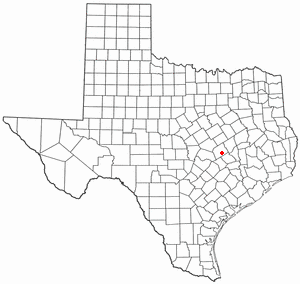
Burleson County is a county located in the U.S. state of Texas. As of the 2020 census, the population was 17,642. Its county seat is Caldwell. The county is named for Edward Burleson, a general and statesman of the Texas Revolution.
Buckholts is a town in Milam County, Texas, United States. Its population was 515 at the 2010 census. The town was founded in 1887, and had a movie theater and a hospital in the early 1920s, with a population around 1000 people.
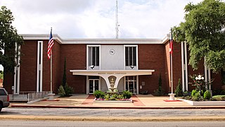
Cameron is a city in Milam County, Texas, United States. Its population was 5,306 at the 2020 census. It is the county seat of Milam County.
Milano is a city in Milam County, Texas, United States, located at the intersection of U.S. Route 79 and State Highway 36, twelve miles southeast of Cameron, the county seat. Its population was 390 at the 2020 census.
Rockdale is a city in Milam County, Texas, United States. Its population was 5,323 at the 2020 census. It is approximately 41 miles west of College Station.
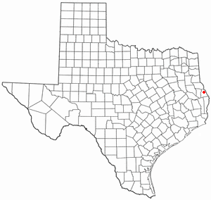
Milam is a census-designated place (CDP) in Sabine County, Texas, United States. It is located along the Sabine River at the junction of Highway 87 and Highway 21. The population was 1,355 at the 2020 census. Milam is the largest city in Sabine County.
Thorndale is a city in Milam County, Texas, United States, with a small section in Williamson County. The population was 1,263 at the 2020 census. It was founded in 1878, approximately three miles west of its present site, and moved to its current site in 1880.