Sabine County, Texas

Last updated

Sabine County
Sabine county tx courthouse 2015.jpg
The Sabine County Courthouse
Map of Texas highlighting Sabine County.svg
Location within the U.S. state of Texas
Texas in United States.svg
Texas's location within the U.S.
Coordinates: 31°20′N93°51′W / 31.34°N 93.85°W / 31.34; -93.85
CountryFlag of the United States.svg United States
StateFlag of Texas.svg  Texas
Founded1837
Named for Sabine River
Seat Hemphill
Largest city Milam
Area
  Total577 sq mi (1,490 km2)
  Land491 sq mi (1,270 km2)
  Water85 sq mi (220 km2)  15%
Population
 (2020)
  Total9,894
  Estimate 
(2022)
10,048 Increase2.svg
  Density17/sq mi (6.6/km2)
Time zone UTC−6 (Central)
  Summer (DST) UTC−5 (CDT)
Congressional district 1st
Website www.co.sabine.tx.us

Sabine County is a county located on the central eastern border of the U.S. state of Texas. As of the 2020 census, its population was 9,894. [1] The county was organized on December 14, 1837, and named for the Sabine River, which forms its eastern border.

Contents

Geography

According to the United States Census Bureau, the county has a total area of 577 square miles (1,490 km2), of which 491 square miles (1,270 km2) is land and 85 square miles (220 km2) (15%) is water. [2]

Major highways

National Protected Areas

Adjacent counties and parish

History

Like other eastern Texas counties, Sabine was originally developed as cotton plantations, which depended on the labor of numerous enslaved African Americans. After the Civil War and emancipation, many freedmen remained in the rural area, working as tenant farmers and sharecroppers. There was considerable violence by whites against blacks during and after Reconstruction. After 1877 and through the early 20th century, Sabine County had 10 lynchings of blacks by whites in acts of racial terrorism. This was the fourth-highest total in the state, where lynchings took place in nearly all counties through this period. [3]

From 1930 to 1970, the population declined as many African Americans left this rural county and other parts of the South in the Great Migration to escape Jim Crow oppression and seek better jobs, especially in Northern industrial cities and on the West Coast, where the defense industry built up during World War II.[ citation needed ]

Demographics

Historical population
CensusPop.Note
1850 2,498
1860 2,75010.1%
1870 3,25618.4%
1880 4,16127.8%
1890 4,96919.4%
1900 6,39428.7%
1910 8,58234.2%
1920 12,29943.3%
1930 11,998−2.4%
1940 10,896−9.2%
1950 8,568−21.4%
1960 7,302−14.8%
1970 7,187−1.6%
1980 8,70221.1%
1990 9,58610.2%
2000 10,4699.2%
2010 10,8343.5%
2020 9,894−8.7%
2022 (est.)10,048 [4] 1.6%
U.S. Decennial Census [5]
1850–2010 [6] 2010-2020 [1]

2020 census

Sabine County, Texas - Demographic Profile
(NH = Non-Hispanic)
Race / EthnicityPop 2010 [7] Pop 2020 [8] % 2010% 2020
White alone (NH)9,4849,89487.54%83.96%
Black or African American alone (NH)7787347.18%7.42%
Native American or Alaska Native alone (NH)54510.50%0.52%
Asian alone (NH)33520.30%0.53%
Pacific Islander alone (NH)000.00%0.00%
Some Other Race alone (NH)6350.06%0.35%
Mixed Race/Multi-Racial (NH)1353221.25%3.25%
Hispanic or Latino (any race)3443933.18%3.97%
Total10,8349,894100.00%100.00%

Note: the US Census treats Hispanic/Latino as an ethnic category. This table excludes Latinos from the racial categories and assigns them to a separate category. Hispanics/Latinos can be of any race.

2000 Census

As of the census [9] of 2000, there were 10,469 people, 4,485 households, and 3,157 families residing in the county. The population density was 21 people per square mile (8.1 people/km2). There were 7,659 housing units at an average density of 16 units per square mile (6.2/km2). The racial makeup of the county was 87.85% White, 9.92% Black or African American, 0.41% Native American, 0.09% Asian, 0.03% Pacific Islander, 0.82% from other races, and 0.88% from two or more races. 1.81% of the population were Hispanic or Latino of any race.

There were 4,485 households, out of which 23.60% had children under the age of 18 living with them, 58.90% were married couples living together, 8.70% had a female householder with no husband present, and 29.60% were non-families. 27.00% of all households were made up of individuals, and 15.40% had someone living alone who was 65 years of age or older. The average household size was 2.31 and the average family size was 2.78.

In the county, the population was spread out, with 21.10% under the age of 18, 5.60% from 18 to 24, 21.10% from 25 to 44, 27.20% from 45 to 64, and 24.90% who were 65 years of age or older. The median age was 47 years. For every 100 females there were 93.40 males. For every 100 females age 18 and over, there were 92.70 males.

The median income for a household in the county was $27,198, and the median income for a family was $32,554. Males had a median income of $28,695 versus $21,141 for females. The per capita income for the county was $15,821. About 11.80% of families and 15.90% of the population were below the poverty line, including 23.90% of those under age 18 and 12.70% of those age 65 or over.

Education

The following school districts serve Sabine County:

The county is in the service area of Angelina College. [10]

Communities

Cities

Unincorporated areas

Census-designated places

Unincorporated communities

Historical communities

COVID-19 pandemic

In July 2021, Sabine County ranked the highest in the United States for cases of Coronavirus per 100,000 people. [12]

Politics

Sabine County has become a solidly Republican county since the beginning of the 21st century but previously leaned Democratic, voting for Bill Clinton in both 1992 and 1996 and also against Texan George H. W. Bush in 1988 and 1992.

Sabine County is represented in the Texas House of Representatives by Republican Travis Clardy.

United States presidential election results for Sabine County, Texas [13]
Year Republican Democratic Third party
No.%No.%No.%
2020 4,78487.12%66912.18%380.69%
2016 3,99885.96%61413.20%390.84%
2012 3,72781.41%80717.63%440.96%
2008 3,74976.92%1,07722.10%480.98%
2004 3,13867.64%1,47631.82%250.54%
2000 2,76460.20%1,75338.18%741.61%
1996 1,66042.29%1,91348.74%3528.97%
1992 1,49031.85%2,28848.91%90019.24%
1988 1,92548.28%2,05351.49%90.23%
1984 2,04551.21%1,94048.59%80.20%
1980 1,38740.82%1,98358.36%280.82%
1976 90427.43%2,39172.54%10.03%
1972 1,33358.64%93641.18%40.18%
1968 45518.44%1,07843.68%93537.88%
1964 42819.19%1,80180.76%10.04%
1960 61933.59%1,20865.55%160.87%
1956 80146.71%91353.24%10.06%
1952 72931.67%1,57368.33%00.00%
1948 1047.26%1,07875.28%25017.46%
1944 20314.01%1,16980.68%775.31%
1940 1578.80%1,62691.09%20.11%
1936 1088.14%1,21691.70%20.15%
1932 573.08%1,78996.76%30.16%
1928 41934.18%80765.82%00.00%
1924 615.01%1,15094.42%70.57%
1920 616.19%63764.67%28729.14%
1916 222.90%68189.72%567.38%
1912 193.70%42582.85%6913.45%

See also

Related Research Articles

<span class="mw-page-title-main">Orange County, Texas</span> County in Texas, United States

Orange County is a county located in the very southeastern corner of the U.S. state of Texas, sharing a boundary with Louisiana, within the Golden Triangle of Texas. As of the 2020 census, its population was 84,808. The county seat is the city of Orange, and it falls within the Beaumont–Port Arthur metropolitan area.

<span class="mw-page-title-main">Wheeler County, Texas</span> County in Texas, United States

Wheeler County is a county located in the U.S. state of Texas. As of the 2020 census, its population was 4,990. Its county seat is Wheeler. The county was formed in 1876 and organized in 1879. It is named for Royall Tyler Wheeler, a chief justice of the Texas Supreme Court.

<span class="mw-page-title-main">San Augustine County, Texas</span> County in Texas, United States

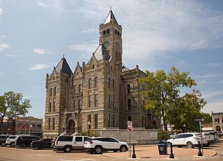
San Augustine County is a county located in the U.S. state of Texas. As of the 2020 census, its population was 7,918. Its county seat is San Augustine.

<span class="mw-page-title-main">Parmer County, Texas</span> County in Texas, United States

Parmer County is a county located in the southwestern Texas Panhandle on the High Plains of the Llano Estacado in the U.S. state of Texas. As of the 2020 Census, the population was 9,869. The county seat is Farwell. The county was created in 1876 and later organized in 1907. It is named in honor of Martin Parmer, a signer of the Texas Declaration of Independence and early judge. Parmer County was one of 10 prohibition, or entirely dry, counties in the state of Texas, but is now a wet county.

<span class="mw-page-title-main">Newton County, Texas</span> County in Texas, United States

Newton County is the easternmost county in the U.S. state of Texas. As of the 2020 census, its population was 12,217. Its county seat is Newton. The county is named for John Newton, a veteran of the American Revolutionary War.

<span class="mw-page-title-main">Lavaca County, Texas</span> County in Texas, United States

Lavaca County is a county located in the U.S. state of Texas. As of the 2020 census, its population was 20,337. Its county seat is Hallettsville. The county was created in 1846. It is named for the Lavaca River, which curves its way southeast through Moulton and Hallettsville before reaching the coast at Matagorda Bay.

<span class="mw-page-title-main">Jasper County, Texas</span> County in Texas, United States

Jasper County is a county located in the U.S. state of Texas. As of the 2020 census, its population was 32,980. Its county seat is Jasper. The county was created as a municipality in Mexico in 1834, and in 1837 was organized as a county in the Republic of Texas. It is named for William Jasper, an American Revolutionary War hero.

<span class="mw-page-title-main">Hopkins County, Texas</span> County in Texas, United States

Hopkins County is a county located in the U.S. state of Texas. As of the 2020 census, its population was 36,787. Its county seat is Sulphur Springs. Hopkins County is named for the family of David Hopkins, an early settler in the area. Hopkins County comprises the Sulphur Springs, TX Micropolitan Statistical Area. Hopkins County was once known as the Dairy Capital of Texas. Although dairy farms declined in the area in the late 1990s there are still a number of these located there. The Southwest Dairy Museum is located in Sulphur Springs.

<span class="mw-page-title-main">Hemphill County, Texas</span> County in Texas, United States

Hemphill County is a county located in the U.S. state of Texas. As of the 2020 census, its population was 3,382. The county seat and only incorporated community in the county is the city of Canadian. The county was created in 1876 and organized in 1887. It is named for John Hemphill, a judge and Confederate congressman. Hemphill County is the most recent Texas county to permit alcohol sales.

<span class="mw-page-title-main">Gray County, Texas</span> County in Texas, United States

Gray County is a county located in the U.S. state of Texas. As of the 2020 census, its population was 21,227. The county seat is Pampa. The county was created in 1876 and later organized in 1902. is named for Peter W. Gray, a Confederate lawyer and soldier in the American Civil War.

<span class="mw-page-title-main">Cochran County, Texas</span> County in Texas, United States

Cochran County is a county located in the U.S. state of Texas. As of the 2020 census, its population was 2,547. The county seat is Morton. The county was created in 1876 and later organized in 1924. It is named for Robert E. Cochran, a defender of the Alamo.

<span class="mw-page-title-main">Brazos County, Texas</span> County in Texas, United States

Brazos County is a county in the U.S. state of Texas. As of the 2020 census, its population was 233,849. The county seat is Bryan. Along with Brazoria County, the county is named for the Brazos River, which forms its western border. The county was formed in 1841 and organized in 1843.

<span class="mw-page-title-main">Liberty City, Texas</span> Census-designated place in Texas, United States

Liberty City is a census-designated place (CDP) in Gregg County, Texas, United States. The population was 2,721 at the 2020 census, an increase over the figure of 2,351 tabulated in 2010.

<span class="mw-page-title-main">Browndell, Texas</span> City in Texas, United States

Browndell is a city in Jasper County, Texas, United States. The population was 160 at the 2020 census.

<span class="mw-page-title-main">Buna, Texas</span> Census-designated place in Texas, United States

Buna is an unincorporated community and census-designated place (CDP) in Jasper County, Texas, United States. The population was 2,137 at the 2020 census.

<span class="mw-page-title-main">Deweyville, Texas</span> CDP in Texas, United States

Deweyville is a census-designated place (CDP) in Newton County, on the central eastern border of Texas, United States. The population was 571 at the 2020 census, down from 1,023 at the 2010 census.

<span class="mw-page-title-main">Hemphill, Texas</span> City in Texas, United States

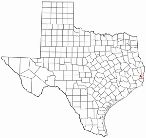
Hemphill is a city in Sabine County, Texas, United States. The population was 1,029 at the 2020 census. It is the county seat of Sabine County. It is located on State Highway 87 at the junction of State Highway 184, and is surrounded by the Sabine National Forest and the Toledo Bend Reservoir.

<span class="mw-page-title-main">Milam, Texas</span> CDP in Texas, United States

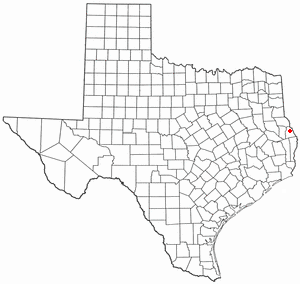
Milam is a census-designated place (CDP) in Sabine County, Texas, United States. It is located along the Sabine River at the junction of Highway 87 and Highway 21. The population was 1,355 at the 2020 census. Milam is the largest city in Sabine County.

<span class="mw-page-title-main">Pineland, Texas</span> City in Texas, United States

Pineland is a city in Sabine County, Texas, United States. The population was 888 at the 2020 census.

<span class="mw-page-title-main">Moore County, Texas</span> County in Texas, United States

Moore County is a county located in the U.S. state of Texas. As of the 2020 census, its population was 21,358. The county seat is Dumas. The county was created in 1876 and organized in 1892. It is named for Edwin Ward Moore, the commander of the Texas Navy. The Dumas micropolitan statistical area includes all of Moore County.

References

  1. 1 2 "State & County QuickFacts". United States Census Bureau. Retrieved December 17, 2023.
  2. "2010 Census Gazetteer Files". United States Census Bureau. August 22, 2012. Retrieved May 10, 2015.
  3. Lynching in America, Third Edition: Supplement by County, pp. 9-10, Equal Justice Initiative, Mobile, Alabama, 2017.
  4. "Annual Estimates of the Resident Population for Counties: April 1, 2020 to July 1, 2022" . Retrieved December 17, 2023.
  5. "U.S. Decennial Census". United States Census Bureau. Retrieved March 26, 2015.
  6. "Texas Almanac: Population History of Counties from 1850–2010" (PDF). Texas Almanac. Archived (PDF) from the original on October 9, 2022. Retrieved May 10, 2015.
  7. "P2 HISPANIC OR LATINO, AND NOT HISPANIC OR LATINO BY RACE - 2010: DEC Redistricting Data (PL 94-171) - Sabine County, Texas". United States Census Bureau .
  8. "P2 HISPANIC OR LATINO, AND NOT HISPANIC OR LATINO BY RACE - 2020: DEC Redistricting Data (PL 94-171) - Sabine County, Texas". United States Census Bureau .
  9. "U.S. Census website". United States Census Bureau . Retrieved May 14, 2011.
  10. Texas Education Code, Sec. 130.165. ANGELINA COUNTY JUNIOR COLLEGE DISTRICT SERVICE AREA, Statutes.capitol.texas.gov
  11. "Archived copy". Archived from the original on October 24, 2020. Retrieved September 4, 2014.{{cite web}}: CS1 maint: archived copy as title (link)
  12. Times, The New York (March 3, 2020). "Coronavirus in the U.S.: Latest Map and Case Count". The New York Times . Retrieved February 8, 2022.
  13. Leip, David. "Dave Leip's Atlas of U.S. Presidential Elections". uselectionatlas.org. Retrieved July 30, 2018.

31°20′N93°51′W / 31.34°N 93.85°W / 31.34; -93.85