Kleberg County, Texas

Last updated

Kleberg County
Kleberg courthouse.jpg
The Kleberg County Courthouse in Kingsville. The building was added to the National Register of Historic Places on May 10, 2010.
Map of Texas highlighting Kleberg County.svg
Location within the U.S. state of Texas
Texas in United States.svg
Texas's location within the U.S.
Coordinates: 27°26′N97°40′W / 27.43°N 97.66°W / 27.43; -97.66
CountryFlag of the United States.svg United States
StateFlag of Texas.svg  Texas
Founded1913
Named for Robert J. Kleberg
Seat Kingsville
Largest cityKingsville
Area
  Total1,090 sq mi (2,800 km2)
  Land881 sq mi (2,280 km2)
  Water209 sq mi (540 km2)  19%
Population
 (2020)
  Total31,040
  Density28/sq mi (11/km2)
Time zone UTC−6 (Central)
  Summer (DST) UTC−5 (CDT)
Congressional district 34th
Website www.co.kleberg.tx.us

Kleberg County is a county in the U.S. state of Texas. As of the 2020 census, its population was 31,040. [1] The county seat is Kingsville. [2] The county was organized in 1913 [3] and is named for Robert J. Kleberg, an early settler.

Contents

Kleberg County is part of the Kingsville, TX Micropolitan Statistical Area, which is also part of the Corpus Christi-Kingsville-Alice, TX Combined Statistical Area. Most of the county's land lies in the famed King Ranch, which also extends into neighboring counties.

History

The county was organized in 1913 [4] and was named for Robert J. Kleberg, an early settler (see below).

In 1997, the county commissioners designated "HeavenO" as the county's official greeting because of a taboo stemming from "Hello"'s perceived connotations of Hell. [5] [6]

Robert Justus Kleberg

Robert Justus Kleberg Sr. (1803–1888), a Prussian settler, was born on September 10, 1803, in Herstelle, Westphalia. His father was a merchant.

Kleberg was educated in the classics and attended the University of Göttingen, where he received a J.D. degree. After graduating he was appointed a justice of assizes. He married Rosalie von Roeder near Paderborn, Prussia, in 1834. They emigrated to Texas that year and settled in Cat Spring in 1836.

In the Republic of Texas, Kleberg was associate commissioner and president of the Board of Land Commissioners (1837–38), justice of the peace (1841), and chief justice of Austin County (1846). In 1847 the Kleberg's moved to Meyersville, where Kleberg was elected county commissioner in 1848 and chief justice in 1853.

Kleberg fought in the battle of San Jacinto in Capt. Moseley Baker's company and subsequently served as one of the Texas guards for Gen. Santa Anna. After the revolution, he volunteered for six months' duty in the Texas army in a campaign against the Indians on Escondido Creek.

Kleberg supported the cause of the Confederacy. When the Civil War broke out he raised a company of militia but because of his advanced age was not received into active service. Robert and Rosa raised their own seven children in addition to several young Roeder relatives. Their youngest son, Robert Justus Kleberg Jr. married Alice Gertrudis King.

Kleberg died on October 23, 1888, near Cuero and was buried there. His grave is marked by a monument in the form of a soldier's tent with the words "Remember the Alamo" carved at the base. Kleberg County was named in his honor in 1913; a marker at his home site near Cuero was erected in 1936.

Geography

According to the U.S. Census Bureau, the county has a total area of 1,090 square miles (2,800 km2), of which 881 square miles (2,280 km2) is land and 209 square miles (540 km2) (19%) is water. [7] It borders the Gulf of Mexico. Baffin Bay makes up a large part of the border with Kenedy County.

Major highways

Adjacent counties

National protected area

Demographics

Historical population
CensusPop.Note
1920 7,837
1930 12,45158.9%
1940 13,3447.2%
1950 21,99164.8%
1960 30,05236.7%
1970 33,16610.4%
1980 33,3580.6%
1990 30,274−9.2%
2000 31,5494.2%
2010 32,0611.6%
2020 31,040−3.2%
U.S. Decennial Census [8]
1850–2010 [9] 2010 [10] 2020 [11]

2020 census

Kleberg County, Texas - Demographic Profile
(NH = Non-Hispanic)
Race / EthnicityPop 2010 [10] Pop 2020 [11] % 2010% 2020
White alone (NH)7,4796,72823.33%21.68%
Black or African American alone (NH)1,0709953.34%3.21%
Native American or Alaska Native alone (NH)51830.16%0.27%
Asian alone (NH)7157842.23%2.53%
Pacific Islander alone (NH)2610.08%0.00%
Some Other Race alone (NH)28970.09%0.31%
Mixed Race/Multi-Racial (NH)1974320.61%1.39%
Hispanic or Latino (any race)22,49521,92070.16%70.62%
Total32,06131,040100.00%100.00%

Note: the US Census treats Hispanic/Latino as an ethnic category. This table excludes Latinos from the racial categories and assigns them to a separate category. Hispanics/Latinos can be of any race.

2000 Census

As of the census [12] of 2000, there were 31,549 people, 10,896 households, and 7,681 families residing in the county. The population density was 36 people per square mile (14 people/km2). There were 12,743 housing units at an average density of 15 units per square mile (5.8/km2). The racial makeup of the county was 71.87% White, 3.70% Black or African American, 0.61% Native American, 1.47% Asian, 0.10% Pacific Islander, 19.00% from other races, and 3.25% from two or more races. 65.41% of the population were Hispanic or Latino of any race.

There were 10,896 households, out of which 34.90% had children under the age of 18 living with them, 52.10% were married couples living together, 13.90% had a female householder with no husband present, and 29.50% were non-families. 22.30% of all households were made up of individuals, and 7.60% had someone living alone who was 65 years of age or older. The average household size was 2.78 and the average family size was 3.30.

In the county, the population was spread out, with 27.30% under the age of 18, 15.70% from 18 to 24, 27.40% from 25 to 44, 19.00% from 45 to 64, and 10.60% who were 65 years of age or older. The median age was 29 years. For every 100 females, there were 101.00 males. For every 100 females age 18 and over, there were 98.50 males.

The median income for a household in the county was $29,313, and the median income for a family was $33,055. Males had a median income of $31,179 versus $19,494 for females. The per capita income for the county was $13,542. About 21.20% of families and 26.70% of the population were below the poverty line, including 35.50% of those under age 18 and 15.60% of those age 65 or over.

Religion

68.1% of the people in Kleberg County are religious: 37.3% are Catholics, 9.8% are Baptists, 8% are Muslims, 3.3% are Methodists, 2.7% are Pentecostals, 2.0% are Mormons, 0.9% are Lutherans, 0.7% are Presbyterians, 0.6% are Episcopalians and 2.8% are from another Christian faith. [13]


Communities

Cities and towns

Census-designated places

Unincorporated community

Politics

United States presidential election results for Kleberg County, Texas [14]
Year Republican Democratic Third party
No.%No.%No.%
2020 5,50450.29%5,31448.56%1261.15%
2016 4,36745.55%4,71649.19%5045.26%
2012 4,05845.56%4,75453.37%951.07%
2008 4,54045.97%5,25653.22%800.81%
2004 5,36653.81%4,55045.62%570.57%
2000 4,52649.23%4,48148.74%1872.03%
1996 3,39137.68%5,13657.07%4725.25%
1992 3,89736.89%5,10948.36%1,55814.75%
1988 4,44344.67%5,36753.96%1361.37%
1984 5,71253.48%4,92446.10%450.42%
1980 4,60845.84%5,12550.98%3203.18%
1976 3,77139.09%5,80360.15%730.76%
1972 5,31254.19%4,48145.71%100.10%
1968 2,71333.84%4,63357.80%6708.36%
1964 1,65226.52%4,56873.32%100.16%
1960 2,09235.66%3,77364.32%10.02%
1956 2,12146.39%2,43653.28%150.33%
1952 2,03738.94%3,19361.04%10.02%
1948 69724.26%2,08372.50%933.24%
1944 42121.51%1,47375.27%633.22%
1940 42920.78%1,63179.02%40.19%
1936 1569.13%1,48887.12%643.75%
1932 19810.15%1,72788.56%251.28%
1928 75151.94%69548.06%00.00%
1924 22619.57%72162.42%20818.01%
1920 17225.56%45567.61%466.84%
1916 10618.34%42773.88%457.79%

Kleberg County is represented in the Texas House of Representatives by the Republican J. M. Lozano, a restaurateur in Kingsville, Portland, Callen, and in Alice, Texas. Kleberg County has leaned Democratic for most of its history but has become more competitive in the 21st century. An indicator of that trend is Lozano who was originally a Democrat but switched to the Republicans in 2012. Also, Kleberg County Attorney Kira Talip Sanchez was originally elected as a Democrat in 2014, but she announced in August 2023 that she switched parties and is now a Republican. [15] Kleberg County has voted three times for either narrowly winning or losing Republicans (George W. Bush in 2000 and 2004, and Donald Trump in 2020).

Education

School districts include:

Coastal Bend College (formerly Bee County College) is the designated community college for the Kingsville, Ricardo, and Santa Gertrudis school district areas. The Riviera ISD portion is in the Del Mar College-Corpus Christi Junior College District. [16]

See also

Related Research Articles

<span class="mw-page-title-main">Willacy County, Texas</span> County in Texas, United States

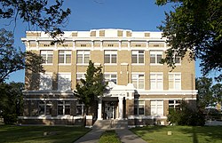
Willacy County is a county in the U.S. state of Texas. As of the 2020 census, its population was 20,164. Its county seat is Raymondville. The county was created in 1911 and organized the next year.

<span class="mw-page-title-main">San Patricio County, Texas</span> County in Texas, United States

San Patricio County is located in the U.S. state of Texas. As of the 2020 census, its population was 68,755. Its county seat is Sinton. San Patricio County is part of the Corpus Christi metropolitan statistical area.

<span class="mw-page-title-main">Nueces County, Texas</span> County in Texas, United States

Nueces County is located in the U.S. state of Texas. As of the 2020 census, the population was 353,178, making it the 16th-most populous county in the state. The county seat is Corpus Christi. The county was formed in 1846 from portions of San Patricio County and organized the following year. It is named for the Nueces River, which marks the county's northwestern boundary with San Patricio County before emptying into its mouth at Nueces Bay north of the port of Corpus Christi. Nueces County is part of the Corpus Christi metropolitan statistical area.

<span class="mw-page-title-main">Midland County, Texas</span> County in Texas, United States

Midland County is a county located in the U.S. state of Texas. As of 2020, the population was 169,983. The county seat is Midland. The county is so named for being halfway (midway) between Fort Worth and El Paso on the Texas and Pacific Railway. Midland County is included in the Midland, TX Metropolitan Statistical Area as well as the Midland–Odessa Combined Statistical Area.

<span class="mw-page-title-main">Kenedy County, Texas</span> County in Texas, United States

Kenedy County is a county located in the U.S. state of Texas. As of the 2020 census, its population was 350. It is the third-least populous county in Texas and fourth-least populous in the United States. Its county seat is Sarita. The county was created in 1921 from parts of Hidalgo and Willacy counties and is named for Mifflin Kenedy, an early area rancher and steamboat operator.

<span class="mw-page-title-main">Karnes County, Texas</span> County in Texas, United States

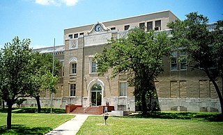
Karnes County is a county in the U.S. state of Texas. As of the 2020 census, the population was 14,710. Its county seat is Karnes City. The county is named for Henry Karnes, a soldier in the Texas Revolution. The former San Antonio and Aransas Pass Railway passed through Karnes County in its connection linking San Antonio with Corpus Christi.

<span class="mw-page-title-main">Jim Wells County, Texas</span> County in Texas, United States

Jim Wells County is a county in the U.S. state of Texas. As of the 2020 census, its population was 38,891. The county was founded in 1911 and is named for James B. Wells Jr. (1850–1923), for three decades a judge and Democratic Party political boss in South Texas.

<span class="mw-page-title-main">DeWitt County, Texas</span> County in Texas, United States

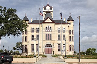
DeWitt County is a county located in the U.S. state of Texas. As of the 2020 census, its population was 19,824. The county seat is Cuero. The county was founded in 1846 and is named for Green DeWitt, who founded an early colony in Texas.

<span class="mw-page-title-main">Dawson County, Texas</span> County in Texas, United States

Dawson County is a county in the U.S. state of Texas. As of the 2020 census, its population was 12,456. The county seat is Lamesa. The county was created in 1876 and later organized in 1905. It is named for Nicholas Mosby Dawson, a soldier of the Texas Revolution. Dawson County comprises the Lamesa, TX Micropolitan Statistical Area (μSA), and it is, by population, the smallest Micropolitan Statistical Area in the United States.

<span class="mw-page-title-main">Aransas County, Texas</span> County in Texas, United States

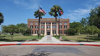
Aransas County is a county located in the U.S. state of Texas. It is in South Texas and its county seat is Rockport.

<span class="mw-page-title-main">Port Lavaca, Texas</span> City in Texas, United States

Port Lavaca is a city in Calhoun County, located in the U.S. state of Texas. The population was 12,248 at the 2010 census and 11,557 at the 2020 census. It is the county seat of Calhoun County and part of the Port Lavaca, Texas micropolitan statistical area. Port Lavaca is 130 miles (210 km) southwest of Houston.

<span class="mw-page-title-main">Cuero, Texas</span> City in Texas, United States

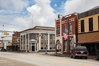
Cuero is a city in and the county seat of DeWitt County, Texas, United States. Its population was 8,128 at the 2020 census.

<span class="mw-page-title-main">Nordheim, Texas</span> City in Texas, United States

Nordheim is a city in DeWitt County, Texas, United States. The population was 336 at the 2020 census.

<span class="mw-page-title-main">Alice, Texas</span> City in Texas, United States

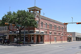
Alice is a city in, and the county seat of, Jim Wells County, Texas, United States, in the South Texas region of the state. The population was 19,104 at the 2010 census. Alice was established in 1888. First it was called "Bandana", then "Kleberg", and finally "Alice" after Alice Gertrudis King Kleberg, the daughter of Richard King, who established the King Ranch.

<span class="mw-page-title-main">Orange Grove, Texas</span> City in Texas, United States

Orange Grove is a city in Jim Wells County, Texas, United States. The population was 1,318 at the 2010 census.

<span class="mw-page-title-main">Kenedy, Texas</span> City in Texas, United States

Kenedy is a city in Karnes County, Texas, United States, named for Mifflin Kenedy, who bought 400,000 acres (1,600 km2) and wanted to develop a new town that would carry his name. The population was 3,473 at the 2020 census, up from 3,296 at the 2010 census.

<span class="mw-page-title-main">Kingsville, Texas</span> City in Texas, United States

Kingsville is a city in the southern region of the U.S. state of Texas and the county seat of Kleberg County. Located on the U.S. Route 77 corridor between Corpus Christi and Harlingen, Kingsville is the principal city of the Kingsville Micropolitan Statistical Area, which is part of the larger Corpus Christi-Kingsville Combined Statistical Area. The population was 25,402 at the 2020 census, and in 2022 the U.S. Census Bureau estimated the population at 24,833.

<span class="mw-page-title-main">Sarita, Texas</span> County seat & Unincorporated community in Texas, United States

Sarita is a census-designated place (CDP) in, and the county seat of Kenedy County, Texas, United States. It is the only settlement of note in the county, and as of the 2010 census had a population of 238.

Riviera Independent School District is a public school district serving about 479 students from Prek-12 grades, it is based in the community of Riviera, Texas (USA).

<span class="mw-page-title-main">Kingsville, Texas micropolitan area</span> Micropolitan Statistical Area in Texas, United States

The Kingsville Micropolitan Statistical Area is a micropolitan area in South Texas that covers one sole county–Kleberg. The micropolitan statistical area also included Kenedy County which was detached in 2023. It is also part of the larger Corpus Christi–Kingsville–Alice Combined Statistical Area.

References

  1. "Kleberg County, Texas". United States Census Bureau . Retrieved February 23, 2021.
  2. "Find a County". National Association of Counties. Archived from the original on May 31, 2011. Retrieved June 7, 2011.
  3. Columbia-Lippincott Gazetteer, p. 959
  4. Columbia-Lippincott Gazetteer, p. 959.
  5. Kelley Shannon, "Say Goodbye to ‘Hello’ and Hello to ‘Heaven-o’", The Los Angeles Times, January 19, 1997.
  6. "Heaven-o", The Chicago Tribune, January 21, 1997.
  7. "2010 Census Gazetteer Files". United States Census Bureau. August 22, 2012. Retrieved May 2, 2015.
  8. "Decennial Census of Population and Housing by Decades". US Census Bureau.
  9. "Texas Almanac: Population History of Counties from 1850–2010" (PDF). Texas Almanac. Archived (PDF) from the original on October 9, 2022. Retrieved May 2, 2015.
  10. 1 2 "P2 Hispanic or Latino, and Not Hispanic or Latino by Race - 2010: DEC Redistricting Data (PL 94-171) - Kleberg County, Texas". United States Census Bureau . Archived from the original on January 9, 2024.
  11. 1 2 "P2 Hispanic or Latino, and Not Hispanic or Latino by Race - 2020: DEC Redistricting Data (PL 94-171) - Kleberg County, Texas". United States Census Bureau . Archived from the original on January 9, 2024.
  12. "U.S. Census". United States Census Bureau . Retrieved May 14, 2011.
  13. https://www.bestplaces.net/religion/county/texas/kleberg
  14. Leip, David. "Dave Leip's Atlas of U.S. Presidential Elections". uselectionatlas.org. Retrieved July 26, 2018.
  15. Goldsberry, Jenny; Zimmermann, David (August 20, 2023). "Texas county attorney leaves Democratic Party for GOP over border crisis". Washington Examiner. Archived from the original on August 20, 2023.
  16. "Texas Education Code, Title 3. Higher Education, Subtitle G. Non-baccalaureate System, Chapter 130. Junior College Districts". Texas Constitution and Statutes. Archived from the original on November 3, 2023. Sec. 130.167. Bee County College District Service Area." "Sec. 130.177. Del Mar College-corpus Christi Junior College District Service Area. The legislation calls it "Bee County College".

27°26′N97°40′W / 27.43°N 97.66°W / 27.43; -97.66