Borden County, Texas

Last updated

Borden County
Borden County Courthouse August 2020.jpg
Borden County Courthouse in Gail
Map of Texas highlighting Borden County.svg
Location within the U.S. state of Texas
Texas in United States.svg
Texas's location within the U.S.
Coordinates: 32°44′N101°26′W / 32.74°N 101.43°W / 32.74; -101.43
CountryFlag of the United States.svg United States
StateFlag of Texas.svg  Texas
Founded1876
Named for Gail Borden Jr.
Seat Gail
Largest communityGail
Area
  Total906 sq mi (2,350 km2)
  Land897 sq mi (2,320 km2)
  Water8.6 sq mi (22 km2)  1.0%
Population
 (2020)
  Total631
  Estimate 
(2022)
585 Decrease2.svg
  Density0.70/sq mi (0.27/km2)
Time zone UTC−6 (Central)
  Summer (DST) UTC−5 (CDT)
Congressional district 19th
Website www.co.borden.tx.us

Borden County is a rural county located in the U.S. state of Texas. It is in West Texas and its county seat is Gail. [1]

Contents

As of the 2020 census, its population was 631, [2] making it the fifth-least populous county in Texas. Borden is one of four remaining prohibition or entirely dry counties in the state of Texas. [3]

The county was created in 1876 and later organized in 1891. [4] Gail and Borden County are named for Gail Borden Jr., businessman, publisher, surveyor, and pioneer of condensed milk.

History

Native Americans

Shoshone and the Penateka band of Comanches were early tribes in the area. [5]

County established

Borden County was created in 1876 from Bosque County and named for Gail Borden Jr., the inventor of condensed milk. Borden was publisher and editor of the Telegraph and Texas Register , as well as a political leader in the Republic of Texas. The county was organized in 1891, and Gail was made the county seat. [6]

Farmers and ranchers settled the county, but the population remained relatively small. In 1902, Texas placed lands in the public domain and spurred a land rush in Borden County. Many of the newcomers grew cotton. [5]

Borden County has had two courthouses, one built in 1890. The current courthouse is of brick and concrete construction and was erected in 1939. The architect was David S. Castle Co. [7]

Oil was discovered in the county in 1949. By 1991, more than 340,000,000 barrels (54,000,000 m3) of petroleum had been taken out of Borden County since its discovery. [8]

Geography

According to the United States Census Bureau, the county has a total area of 906 square miles (2,350 km2), of which 897 square miles (2,320 km2) are land and 8.6 square miles (22 km2) (1.0%) are covered by water. [9]

Major highways

Adjacent counties

Demographics

Historical population
CensusPop.Note
1880 35
1890 222534.3%
1900 776249.5%
1910 1,38678.6%
1920 965−30.4%
1930 1,50556.0%
1940 1,396−7.2%
1950 1,106−20.8%
1960 1,076−2.7%
1970 888−17.5%
1980 859−3.3%
1990 799−7.0%
2000 729−8.8%
2010 641−12.1%
2020 631−1.6%
2022 (est.)585 [10] −7.3%
U.S. Decennial Census [11]
1850–2010 [12] 2010-2020 [2]
Borden County, Texas - Demographic Profile
(NH = Non-Hispanic)
Race / EthnicityPop 2010 [13] Pop 2020 [14] % 2010% 2020
White alone (NH)53952884.09%83.68%
Black or African American alone (NH)010.00%0.16%
Native American or Alaska Native alone (NH)200.31%0.00%
Asian alone (NH)100.16%0.00%
Pacific Islander alone (NH)000.00%0.00%
Some Other Race alone (NH)010.00%0.16%
Mixed Race/Multi-Racial (NH)4150.62%2.38%
Hispanic or Latino (any race)958614.82%13.63%
Total641631100.00%100.00%

Note: the US Census treats Hispanic/Latino as an ethnic category. This table excludes Latinos from the racial categories and assigns them to a separate category. Hispanics/Latinos can be of any race.

As of the census [15] of 2000, 729 people, 292 households, and 216 families resided in the county. The population density was 0.80 people per square mile (0.31 people/km2). The 435 housing units averaged 0.48 units per square mile (0.19/km2). The racial makeup of the county was 90.53% White, 0.14% African American, 0.27% Native American, 6.31% from other races, and 2.74% from two or more races. About 11.93% of the population was Hispanic or Latino of any race.

Of the 292 households, 30.10% had children under the age of 18 living with them, 65.10% were married couples living together, 6.20% had a female householder with no husband present, and 25.70% were not families. Around 22.60% of all households consisted of individuals, and 9.20% had someone living alone who was 65 years of age or older. The average household size was 2.50 and the average family size was 2.93.

In the county, the population was distributed as 24.60% under the age of 18, 6.70% from 18 to 24, 27.40% from 25 to 44, 25.00% from 45 to 64, and 16.30% who were 65 years of age or older. The median age was 40 years. For every 100 females, there were 103.10 males. For every 100 females age 18 and over, there were 108.30 males.

The median income for a household in the county was $29,205, and for a family was $36,458. Males had a median income of $25,556 versus $21,607 for females. The per capita income for the county was $18,364. About 14.00% of the population and 11.80% of families were below the poverty line. Of the total people living in poverty, 14.30% were under the age of 18 and 11.60% were 65 or older.

The county is served by nearby radio stations KBXJ (FM) and KPET (AM), and the various Midland and Odessa radio and TV stations.

The largest self-reported ancestry groups in Borden County are: [16] · English – 17% · Irish – 15% · German – 12% · Mexican – 9% · French (except Basque) – 3% · Scotch-Irish – 3% · Other Hispanic or Latino – 3% · Scottish – 2% · Spanish – 1% · American Indian tribes, specified – 1%

Education

The county is served mostly by Borden County Independent School District.

Media

The weekly newspaper, the Borden Star, covers events for the school and county.

Communities

Politics

Borden County was Donald Trump's second strongest county in 2020, only slightly edged out by Roberts County in the same state. [17]

United States presidential election results for Borden County, Texas [18]
Year Republican Democratic Third party
No.%No.%No.%
2020 39795.43%163.85%30.72%
2016 33090.41%318.49%41.10%
2012 32489.26%328.82%71.93%
2008 31687.53%4011.08%51.39%
2004 30384.40%5515.32%10.28%
2000 28380.17%6217.56%82.27%
1996 19458.08%9327.84%4714.07%
1992 18448.68%10628.04%8823.28%
1988 28362.33%16937.22%20.44%
1984 32569.44%14029.91%30.64%
1980 27967.23%13131.57%51.20%
1976 15038.46%23460.00%61.54%
1972 33076.21%9622.17%71.62%
1968 11730.31%15740.67%11229.02%
1964 15236.28%26663.48%10.24%
1960 16640.39%23055.96%153.65%
1956 12734.51%24065.22%10.27%
1952 18246.43%21053.57%00.00%
1948 187.73%20387.12%125.15%
1944 3411.04%23776.95%3712.01%
1940 4410.50%37589.50%00.00%
1936 2610.48%22088.71%20.81%
1932 72.81%24297.19%00.00%
1928 9857.31%7342.69%00.00%
1924 1010.42%8689.58%00.00%
1920 43.81%8984.76%1211.43%
1916 11.10%8492.31%66.59%
1912 10.76%12897.71%21.53%

See also

Related Research Articles

<span class="mw-page-title-main">Scurry County, Texas</span> County in Texas, United States

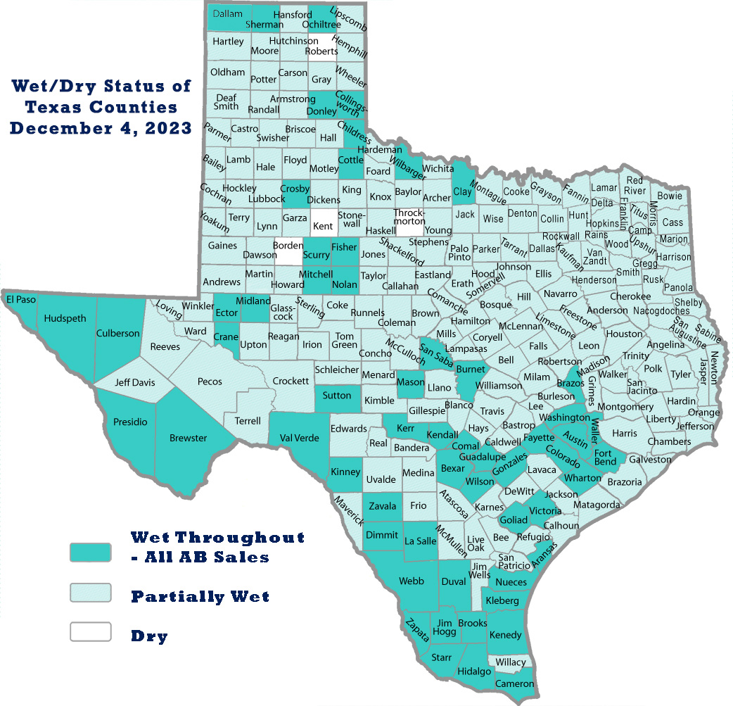
Scurry County is a county located in the U.S. state of Texas. As of the 2020 census, its population was 16,932. Its county seat is Snyder, which is the home for Western Texas College. Scurry County is named for Confederate General William Scurry. The county was created in 1876 and organized in 1884. Scurry County was one of 46 prohibition, or entirely dry, counties in the state of Texas, until a 2006 election approved the sale of beer and wine in Snyder, and a 2008 election approved the sale of liquor by the drink throughout the county.

<span class="mw-page-title-main">Rains County, Texas</span> County in Texas, United States

Rains County is a county located in the U.S. state of Texas. As of the 2020 census, its population was 12,164. Its seat is Emory. The county are named for Emory Rains, a Texas state legislator.

<span class="mw-page-title-main">Morris County, Texas</span> County in Texas, United States

Morris County is a county located near the eastern border of the U.S. state of Texas. As of the 2020 census, its population was 11,973. Its county seat is Daingerfield. Morris County is probably named for William Wright Morris, an early judge and planter from Henderson, also in northeast Texas. As of 2016, Morris County is no longer one of six entirely dry, prohibition counties in the state of Texas. Morris County is "partially wet."

<span class="mw-page-title-main">Mitchell County, Texas</span> County in Texas, United States

Mitchell County is a county in the U.S. state of Texas. As of the 2020 census, its population was 8,990. Its county seat is Colorado City. The county was created in 1876 and organized in 1881. It is named for Asa and Eli Mitchell, two early settlers and soldiers in the Texas Revolution.

<span class="mw-page-title-main">Medina County, Texas</span> County in Texas, United States

Medina County is a county located in the U.S. state of Texas. As of the 2020 census, its population was 50,748. Its county seat is Hondo. The county is named for the Medina River. The extreme northern part of the county lies within the Edwards Plateau, which elevates into the Texas Hill Country. The Medina Dam, the fourth largest in the nation when completed in 1913, is listed on the National Register of Historic Places. The irrigation project, creating Medina Lake, was built by 1500 skilled workers who worked in shifts operating 24 hours a day to complete the dam in two years. Medina County is part of the San Antonio, TX Metropolitan Statistical Area.

<span class="mw-page-title-main">McMullen County, Texas</span> County in Texas, United States

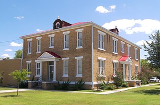
McMullen County is a county located in the U.S. state of Texas. As of the 2020 census, its population was 600, making it the fourth-least populous county in Texas. Its county seat is Tilden. The county was established from parts of Bexar County, Atascosa County, and Live Oak County in 1858 and later organized in 1877. It is named for John McMullen, founder of a colony in Texas. The McMullen County Courthouse was designed by the architect W.C. Stephenson, originally from Buffalo, New York. Stephenson also designed some 50 buildings in Beeville, including the Bee County Courthouse.

<span class="mw-page-title-main">Madison County, Texas</span> County in Texas, United States

Madison County is a county located in the U.S. state of Texas. As of the 2020 census, its population was 13,455. Its seat is Madisonville. The county was created in 1853 and organized the next year. It is named for James Madison, the fourth President of the United States. Hillary Mercer Crabb. In 1852 he was elected to serve the unexpired term of State Representative F. L. Hatch. Among Crabb's accomplishments as a legislator was the introduction of a bill to create Madison County.

<span class="mw-page-title-main">Live Oak County, Texas</span> County in Texas, United States

Live Oak County is a county in the U.S. state of Texas. It was named for its native groves of live oak. George West is its county seat. Its population was 11,335 in the 2020 census.

<span class="mw-page-title-main">Leon County, Texas</span> County in Texas, United States

Leon County is a county in the U.S. state of Texas. As of the 2020 census, its population was 15,719. Its county seat is Centerville.

<span class="mw-page-title-main">Howard County, Texas</span> County in Texas, United States

Howard County is a county located in the U.S. state of Texas. At the 2020 census, its population was 34,860. Its county seat is Big Spring. The county was created in 1876 and organized in 1882. It is named for Volney E. Howard, a U.S. Congressman from Texas.

<span class="mw-page-title-main">Hardin County, Texas</span> County in Texas, United States

Hardin County is a county located in the U.S. state of Texas, United States. As of the 2020 census, its population was 56,231. The county seat is Kountze. The county is named for the family of William Hardin from Liberty County, Texas.

<span class="mw-page-title-main">Glasscock County, Texas</span> County in Texas, United States

Glasscock County is a county located in the U.S. state of Texas. As of the 2020 census, its population was 1,169. Its county seat is Garden City. The county was created in 1827 and later organized in 1869. It is named for George Washington Glasscock, an early settler of the Austin, Texas area and the namesake of Georgetown, Texas.

<span class="mw-page-title-main">Ector County, Texas</span> County in Texas, United States

Ector County is a county located in the U.S. state of Texas. In the 2020 census, its population was 165,171. Its county seat is Odessa. The county was founded in 1887 and organized in 1891. It is named for Matthew Ector, a Confederate general in the American Civil War.

<span class="mw-page-title-main">Dawson County, Texas</span> County in Texas, United States

Dawson County is a county in the U.S. state of Texas. As of the 2020 census, its population was 12,456. The county seat is Lamesa. The county was created in 1876 and later organized in 1905. It is named for Nicholas Mosby Dawson, a soldier of the Texas Revolution. Dawson County comprises the Lamesa, TX Micropolitan Statistical Area (μSA), and it is, by population, the smallest Micropolitan Statistical Area in the United States.

<span class="mw-page-title-main">Burleson County, Texas</span> County in Texas, United States

Burleson County is a county located in the U.S. state of Texas. As of the 2020 census, the population was 17,642. Its county seat is Caldwell. The county is named for Edward Burleson, a general and statesman of the Texas Revolution.

<span class="mw-page-title-main">Atascosa County, Texas</span> County in Texas, United States

Atascosa County is a county located in the U.S. state of Texas. It is in South Texas and its county seat is Jourdanton.

<span class="mw-page-title-main">Blanco, Texas</span> City in Texas, United States

Blanco is a city in rural Blanco County, Texas, United States. The population was 1,739 at the 2010 census. Blanco is a cattle and ranching community.

<span class="mw-page-title-main">Gail, Texas</span> Unincorporated community in Texas, United States

Gail is an unincorporated community in Borden County, Texas, United States. Located at the junction of U.S. Highway 180 and Farm to Market Road 669, it is the county seat of Borden County. As of the 2010 Census, the population was 231.

<span class="mw-page-title-main">Moore County, Texas</span> County in Texas, United States

Moore County is a county located in the U.S. state of Texas. As of the 2020 census, its population was 21,358. The county seat is Dumas. The county was created in 1876 and organized in 1892. It is named for Edwin Ward Moore, the commander of the Texas Navy. The Dumas micropolitan statistical area includes all of Moore County.

<span class="mw-page-title-main">Runnels County, Texas</span> County in Texas, United States

Runnels County is a county located in the U.S. state of Texas. As of the 2020 census, its population was 9,900. Its county seat is Ballinger. The county was created in 1858 and later organized in 1880. It is named for Hiram G. Runnels, a Texas state legislator.

References

  1. "Find a County". National Association of Counties. Archived from the original on May 31, 2011. Retrieved June 7, 2011.
  2. 1 2 "State & County QuickFacts". United States Census Bureau. Retrieved December 16, 2023.
  3. "Wet/Dry Status of Texas Counties". June 1, 2023.
  4. "Texas: Individual County Chronologies". Texas Atlas of Historical County Boundaries. The Newberry Library. 2008. Archived from the original on May 13, 2015. Retrieved May 20, 2015.
  5. 1 2 Leffler, John; Hunt, William R. "Borden County, Texas". Handbook of Texas Online. Texas State Historical Association. Retrieved December 13, 2010.
  6. Hunt, William R. "Gail, Texas". Handbook of Texas Online. Texas State Historical Association. Retrieved December 13, 2010.
  7. "Borden County Courthouse". Texas Escapes. Blueprints For Travel, LLC. Retrieved December 13, 2010.
  8. Olien, Roger M; Hinton, Diana Davids (2007). Wildcatters: Texas Independent Oilmen. TAMU Press. p. 99. ISBN   978-1-58544-606-3.
  9. "2010 Census Gazetteer Files". United States Census Bureau. August 22, 2012. Retrieved April 19, 2015.
  10. "Annual Estimates of the Resident Population for Counties: April 1, 2020 to July 1, 2022" . Retrieved December 16, 2023.
  11. "U.S. Decennial Census". United States Census Bureau. Retrieved March 26, 2015.
  12. "Texas Almanac: Population History of Counties from 1850–2010" (PDF). Texas Almanac. Archived (PDF) from the original on October 9, 2022. Retrieved April 19, 2015.
  13. "P2 HISPANIC OR LATINO, AND NOT HISPANIC OR LATINO BY RACE - 2010: DEC Redistricting Data (PL 94-171) - Borden County, Texas". United States Census Bureau .
  14. "P2 HISPANIC OR LATINO, AND NOT HISPANIC OR LATINO BY RACE - 2020: DEC Redistricting Data (PL 94-171) - Borden County, Texas". United States Census Bureau .
  15. "U.S. Census website". United States Census Bureau . Retrieved May 14, 2011.
  16. "Borden County, TX – Borden County, Texas – Ancestry & family history – ePodunk". epodunk.com. Archived from the original on March 4, 2016. Retrieved July 19, 2018.
  17. "Live election results: 2020 Texas results". Politico election results- Texas. Retrieved November 13, 2020.
  18. Leip, David. "Dave Leip's Atlas of U.S. Presidential Elections". uselectionatlas.org. Retrieved July 19, 2018.

32°44′N101°26′W / 32.74°N 101.43°W / 32.74; -101.43