Leon County, Texas

Last updated

Leon County
Leon-County-Courthouse.JPG
The Leon County Courthouse in Centerville was originally built of slate brick in 1887. Two previous structures have occupied the current site.
Map of Texas highlighting Leon County.svg
Location within the U.S. state of Texas
Texas in United States.svg
Texas's location within the U.S.
Coordinates: 31°18′N96°00′W / 31.3°N 96°W / 31.3; -96
CountryFlag of the United States.svg United States
StateFlag of Texas.svg  Texas
Founded1846
Named for Martín de León
Seat Centerville
Largest city Buffalo
Area
  Total1,081 sq mi (2,800 km2)
  Land1,073 sq mi (2,780 km2)
  Water7.5 sq mi (19 km2)  0.7%
Population
 (2020)
  Total15,719
  Density15/sq mi (5.6/km2)
Time zone UTC−6 (Central)
  Summer (DST) UTC−5 (CDT)
Congressional district 17th
Website www.co.leon.tx.us
Rural Leon High School is located off U.S. Highway 79. Leon High School, Leon County, TX IMG 3030.JPG
Rural Leon High School is located off U.S. Highway 79.

Leon County is a county in the U.S. state of Texas. As of the 2020 census, its population was 15,719. [1] Its county seat is Centerville. [2]

Contents

History

The legislature of the Republic of Texas authorized Leon County in 1846 from part of Robertson County, and named it in honor of Martín de León, the founder of Victoria, Texas. However, local tradition holds that it is named for a yellow wolf of the region commonly called the león (Spanish for lion). The county was organized that same year, with its first county seat at Leona. In 1851, the county seat was moved to Centerville, since Leona was in the far southern part of the county.

The 1886 Leon County Courthouse was designed by architect George Edwin Dickey of Houston, incorporating remnants of an earlier 1858 courthouse that was destroyed by fire. The courthouse was rededicated on July 1, 2007, following a full restoration to a 1909 date. [3]

Geography

According to the U.S. Census Bureau, the county has a total area of 1,081 square miles (2,800 km2), of which 1,073 square miles (2,780 km2) are land and 7.5 square miles (19 km2) (0.7%) are covered by water. [4]

Major highways

Additionally, State Highway OSR runs along the south and southwestern county line of Leon County, where it borders with Madison County.

Adjacent counties

Demographics

Historical population
CensusPop.Note
1850 1,946
1860 6,781248.5%
1870 6,523−3.8%
1880 12,81796.5%
1890 13,8418.0%
1900 18,07230.6%
1910 16,583−8.2%
1920 18,28610.3%
1930 19,8988.8%
1940 17,733−10.9%
1950 12,024−32.2%
1960 9,951−17.2%
1970 8,738−12.2%
1980 9,5949.8%
1990 12,66532.0%
2000 15,33521.1%
2010 16,8019.6%
2020 15,719−6.4%
U.S. Decennial Census [5]
1850–2010 [6] 2010 [7] 2020 [8]
Leon County, Texas - Demographic Profile
(NH = Non-Hispanic)
Race / EthnicityPop 2010 [7] Pop 2020 [8] % 2010% 2020
White alone (NH)13,07811,65977.84%74.17%
Black or African American alone (NH)1,1819217.03%5.86%
Native American or Alaska Native alone (NH)57540.34%0.34%
Asian alone (NH)751110.45%0.71%
Pacific Islander alone (NH)260.01%0.04%
Some Other Race alone (NH)1470.01%0.30%
Mixed Race/Multi-Racial (NH)1474750.87%3.02%
Hispanic or Latino (any race)2,2602,44613.45%15.56%
Total16,80115,719100.00%100.00%

Note: the US Census treats Hispanic/Latino as an ethnic category. This table excludes Latinos from the racial categories and assigns them to a separate category. Hispanics/Latinos can be of any race.

As of the census [9] of 2000, 15,335 people, 6,189 households, and 4,511 families were residing in the county. The population density was 14 people/sq mi (5.4 people/km2). The 8,299 housing units averaged 8 units per square mile (3.1 units/km2). The racial makeup of the county was 83.53% White, 10.39% African American, 0.34% Native American, 0.18% Asian, 4.50% from other races, and 1.06% from two or more races. About 7.91% of the population were Hispanics or Latinos of any race.

Of the 6,189 households, 28.20% had children under 18 living with them, 60.20% were married couples living together, 9.20% had a female householder with no husband present, and 27.10% were not families. About 24.80% of all households were made up of individuals, and 13.10% had someone living alone who was 65 or older. The average household size was 2.46, and the average family size was 2.92.

In the county, the age distribution was 24.3% under 18, 6.7% from 18 to 24, 23.4% from 25 to 44, 25.6% from 45 to 64, and 20.0% who were 65 or older. The median age was 42 years. For every 100 females there were 96.40 males. For every 100 females age 18 and over, there were 92.70 males.

The median income for a household in the county was $30,981, and for a family was $38,029. Males had a median income of $32,036 versus $19,607 for females. The per capita income for the county was $17,599. About 12.60% of families and 15.60% of the population were below the poverty line, including 21.20% of those under age 18 and 14.30% of those age 65 or over.

Communities

Cities

Towns

Census-designated place

Unincorporated communities

Ghost town

Politics

Leon County is so heavily Republican that in 2014 none of the statewide GOP nominees fell below 87 percent of the votes cast. [11]

United States presidential election results for Leon County, Texas [12]
Year Republican Democratic Third party
No.%No.%No.%
2020 7,52386.62%1,07212.34%901.04%
2016 6,39185.91%90912.22%1391.87%
2012 5,81483.53%1,06215.26%841.21%
2008 5,56679.05%1,41820.14%570.81%
2004 5,02373.88%1,75425.80%220.32%
2000 4,36268.95%1,89329.92%711.12%
1996 2,83951.01%2,21739.83%5109.16%
1992 2,21240.16%2,04237.07%1,25422.77%
1988 2,77854.31%2,31645.28%210.41%
1984 3,20763.66%1,82136.15%100.20%
1980 1,82144.93%2,19054.03%421.04%
1976 1,16135.60%2,08563.94%150.46%
1972 1,69966.16%86333.61%60.23%
1968 65921.43%1,53649.95%88028.62%
1964 64221.24%2,37378.52%70.23%
1960 86832.34%1,80367.18%130.48%
1956 1,07945.99%1,26053.71%70.30%
1952 1,26640.66%1,84259.15%60.19%
1948 18410.89%1,23172.84%27516.27%
1944 1407.38%1,56982.67%1899.96%
1940 2529.69%2,34990.31%00.00%
1936 975.25%1,74894.69%10.05%
1932 1085.20%1,95894.32%100.48%
1928 54338.59%86261.27%20.14%
1924 31112.99%2,00483.71%793.30%
1920 22010.58%1,12454.06%73535.35%
1916 33522.70%97966.33%16210.98%
1912 19113.93%85662.44%32423.63%

See also

Related Research Articles

<span class="mw-page-title-main">Trinity County, Texas</span> County in Texas, United States

Trinity County is a county located in the U.S. state of Texas. As of the 2020 census, the population was 13,602. Its county seat is Groveton. The county is named for the Trinity River.

<span class="mw-page-title-main">Robertson County, Texas</span> County in Texas, United States

Robertson County is a county in the U.S. state of Texas. As of the 2020 census, its population was 16,757. Its county seat is Franklin. The county was created in 1837 and organized the following year. It is named for Sterling C. Robertson, an early settler who signed the Texas Declaration of Independence.

<span class="mw-page-title-main">Rains County, Texas</span> County in Texas, United States

Rains County is a county located in the U.S. state of Texas. As of the 2020 census, its population was 12,164. Its seat is Emory. The county are named for Emory Rains, a Texas state legislator.

<span class="mw-page-title-main">Navarro County, Texas</span> County in Texas, United States

Navarro County is a county in the U.S. state of Texas. As of the 2020 census, the population was 52,624. Its county seat is Corsicana. The county is named for José Antonio Navarro, a Tejano leader in the Texas Revolution who signed the Texas Declaration of Independence.

<span class="mw-page-title-main">Medina County, Texas</span> County in Texas, United States

Medina County is a county located in the U.S. state of Texas. As of the 2020 census, its population was 50,748. Its county seat is Hondo. The county is named for the Medina River. The extreme northern part of the county lies within the Edwards Plateau, which elevates into the Texas Hill Country. The Medina Dam, the fourth largest in the nation when completed in 1913, is listed on the National Register of Historic Places. The irrigation project, creating Medina Lake, was built by 1500 skilled workers who worked in shifts operating 24 hours a day to complete the dam in two years. Medina County is part of the San Antonio, TX Metropolitan Statistical Area.

<span class="mw-page-title-main">McMullen County, Texas</span> County in Texas, United States

McMullen County is a county located in the U.S. state of Texas. As of the 2020 census, its population was 600, making it the fourth-least populous county in Texas. Its county seat is Tilden. The county was established from parts of Bexar County, Atascosa County, and Live Oak County in 1858 and later organized in 1877. It is named for John McMullen, founder of a colony in Texas. The McMullen County Courthouse was designed by the architect W.C. Stephenson, originally from Buffalo, New York. Stephenson also designed some 50 buildings in Beeville, including the Bee County Courthouse.

<span class="mw-page-title-main">Matagorda County, Texas</span> County in Texas, United States

Matagorda County is a county located in the U.S. state of Texas. As of the 2020 census, the population was 36,255. Its county seat is Bay City, not to be confused with the larger Baytown in Harris and Chambers Counties. Matagorda County is named for the canebrakes that once grew along the coast.

<span class="mw-page-title-main">Madison County, Texas</span> County in Texas, United States

Madison County is a county located in the U.S. state of Texas. As of the 2020 census, its population was 13,455. Its seat is Madisonville. The county was created in 1853 and organized the next year. It is named for James Madison, the fourth President of the United States. In 1852, Hillary Mercer Crabb was elected to serve the unexpired term of State Representative F. L. Hatch. Among Crabb's accomplishments as a legislator was the introduction of a bill to create Madison County.

<span class="mw-page-title-main">Houston County, Texas</span> County in Texas, United States

Houston County is a county located in the U.S. state of Texas. As of the 2020 census, its population was 22,066. Its county seat is Crockett. Houston County was one of 46 entirely dry counties in the state of Texas, until voters in a November 2007 special election legalized the sale of alcohol in the county.

<span class="mw-page-title-main">Hardin County, Texas</span> County in Texas, United States

Hardin County is a county located in the U.S. state of Texas, United States. As of the 2020 census, its population was 56,231. The county seat is Kountze. The county is named for the family of William Hardin from Liberty County, Texas.

<span class="mw-page-title-main">Freestone County, Texas</span> County in Texas, United States

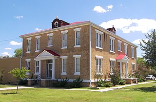
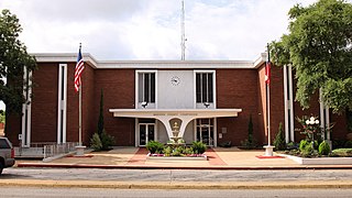
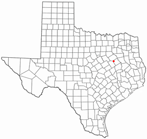
Freestone County is a county in the east-central part of the U.S. state of Texas. As of the 2020 census, its population was 19,435. Its county seat is Fairfield. The county was created in 1850 and organized the next year.

<span class="mw-page-title-main">Brazos County, Texas</span> County in Texas, United States

Brazos County is a county in the U.S. state of Texas. As of the 2020 census, its population was 233,849. The county seat is Bryan. Along with Brazoria County, the county is named for the Brazos River, which forms its western border. The county was formed in 1841 and organized in 1843.

<span class="mw-page-title-main">Atascosa County, Texas</span> County in Texas, United States

Atascosa County is a county located in the U.S. state of Texas. It is in South Texas and its county seat is Jourdanton.

<span class="mw-page-title-main">Page County, Iowa</span> County in Iowa, United States

Page County is a county located in the U.S. state of Iowa. As of the 2020 census, the population was 15,211. The county seat is Clarinda. The county is named in honor of Captain John Page of the 4th U.S. Infantry, who was mortally wounded in the Battle of Palo Alto.

<span class="mw-page-title-main">Appanoose County, Iowa</span> County in Iowa, United States

Appanoose County is a county in the U.S. state of Iowa. As of the 2020 census, the population was 12,317. Its county seat is Centerville.

<span class="mw-page-title-main">Fairfield, Texas</span> City in Texas, United States

Fairfield is a city and county seat of Freestone County, Texas, United States. The population was 2,850 at the 2020 census, down from 3,094 at the 2000 census. It was founded in 1851.

<span class="mw-page-title-main">Teague, Texas</span> City in Texas, United States

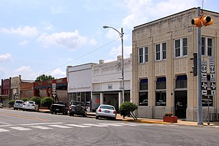
Teague is a city in Freestone County, Texas, United States. The population was 3,384 at the 2020 census.

<span class="mw-page-title-main">Wortham, Texas</span> Town in Texas, United States

Wortham is a town in Freestone County, Texas, United States. The population was 980 at the 2020 census.

<span class="mw-page-title-main">Centerville, Texas</span> City in Texas, United States

Centerville is a city in Leon County, in the U.S. state of Texas. The population was 905 at the 2020 census. It is the county seat of Leon County. Centerville was so named as it is near the geographic center of Leon County.

<span class="mw-page-title-main">Runnels County, Texas</span> County in Texas, United States

Runnels County is a county located in the U.S. state of Texas. As of the 2020 census, its population was 9,900. Its county seat is Ballinger. The county was created in 1858 and later organized in 1880. It is named for Hiram G. Runnels, a Texas state legislator.

References

  1. "Leon County, Texas". United States Census Bureau . Retrieved February 23, 2021.
  2. "Find a County". National Association of Counties. Retrieved June 7, 2011.
  3. Texas Historical Commission.
  4. "2010 Census Gazetteer Files". United States Census Bureau. August 22, 2012. Retrieved May 3, 2015.
  5. "Decennial Census of Population and Housing by Decades". US Census Bureau.
  6. "Texas Almanac: Population History of Counties from 1850–2010" (PDF). Texas Almanac. Archived (PDF) from the original on October 9, 2022. Retrieved May 3, 2015.
  7. 1 2 "P2 HISPANIC OR LATINO, AND NOT HISPANIC OR LATINO BY RACE - 2010: DEC Redistricting Data (PL 94-171) - Leon County, Texas". United States Census Bureau .
  8. 1 2 "P2 HISPANIC OR LATINO, AND NOT HISPANIC OR LATINO BY RACE - 2020: DEC Redistricting Data (PL 94-171) - Leon County, Texas". United States Census Bureau .
  9. "U.S. Census website". United States Census Bureau . Retrieved May 14, 2011.
  10. https://www.ancestry.com/imageviewer/collections/1677/images/32241_1220701439_2090-00286 (Paywalled) [ user-generated source ]
  11. "2014 General Election, Leon County". Texas Secretary of State. Archived from the original on November 29, 2014. Retrieved November 21, 2014.
  12. Leip, David. "Dave Leip's Atlas of U.S. Presidential Elections". uselectionatlas.org. Retrieved July 26, 2018.

31°18′N96°00′W / 31.30°N 96.00°W / 31.30; -96.00