Kent County, Texas

Last updated

Kent County
Kent County Courthouse September 2020.jpg
Kent County Courthouse in Jayton
Map of Texas highlighting Kent County.svg
Location within the U.S. state of Texas
Texas in United States.svg
Texas's location within the U.S.
Coordinates: 33°11′N100°46′W / 33.19°N 100.77°W / 33.19; -100.77
CountryFlag of the United States.svg United States
StateFlag of Texas.svg  Texas
Founded1892
Named for Andrew Kent
Seat Jayton
Largest cityJayton
Area
  Total903 sq mi (2,340 km2)
  Land903 sq mi (2,340 km2)
  Water0.4 sq mi (1 km2)  0.05%
Population
 (2020)
  Total753
  Estimate 
(2022)
740 Decrease2.svg
  Density0.83/sq mi (0.32/km2)
Time zone UTC−6 (Central)
  Summer (DST) UTC−5 (CDT)
Congressional district 19th
Website www.co.kent.tx.us

Kent County is a county located in the U.S. state of Texas. As of the 2020 census, its population was 753, [1] making it the sixth-least populous county in Texas. Its county seat is Jayton. [2] The county was created in 1876 and later organized in 1892. [3] It is named for Andrew Kent, who died at the Battle of the Alamo. Kent County is a prohibition or entirely dry county, [4] one of four remaining in the state. [5]

Contents

History timeline

Geography

According to the United States Census Bureau, the county has a total area of 903 square miles (2,340 km2), of which 903 square miles (2,340 km2) are land and 0.4 square miles (1.0 km2) (0.05%) is covered by water. [10]

Major highways

Adjacent counties

Demographics

Historical population
CensusPop.Note
1880 92
1890 324252.2%
1900 899177.5%
1910 2,655195.3%
1920 3,33525.6%
1930 3,85115.5%
1940 3,413−11.4%
1950 2,249−34.1%
1960 1,727−23.2%
1970 1,434−17.0%
1980 1,145−20.2%
1990 1,010−11.8%
2000 859−15.0%
2010 808−5.9%
2020 753−6.8%
2022 (est.)740 [11] −1.7%
U.S. Decennial Census [12]
1850–2010 [13] 2010-2020 [1]
Kent County, Texas - Demographic Profile
(NH = Non-Hispanic)
Race / EthnicityPop 2010 [14] Pop 2020 [15] % 2010% 2020
   White alone (NH)66965782.80%87.25%
   Black or African American alone (NH)620.74%0.27%
   Native American or Alaska Native alone (NH)530.62%0.40%
Asian alone (NH)000.00%0.00%
Pacific Islander alone (NH)000.00%0.00%
Some Other Race alone (NH)030.00%0.40%
Mixed Race/Multi-Racial (NH)870.99%0.93%
Hispanic or Latino (any race)1208114.85%10.76%
Total808753100.00%100.00%

Note: the US Census treats Hispanic/Latino as an ethnic category. This table excludes Latinos from the racial categories and assigns them to a separate category. Hispanics/Latinos can be of any race.

As of the census [16] of 2000, 859 people, 353 households, and 247 families resided in the county. The population density was less than 1/km2 (2.6/sq mi). The 551 housing units averaged about zero point six units per square mile (0.23 units/km2). The racial makeup of the county was 95.46% White, 0.23% Black or African American, 0.35% Native American, 3.73% from other races, and 0.23% from two or more races. About 9% of the population were Hispanic or Latino of any race.

Of the 353 households, 26.10% had children under the age of 18 living with them, 61.20% were married couples living together, 5.90% had a female householder with no husband present, and 30.00% were not families. About 28% of all households were made up of individuals, and 14.20% had someone living alone who was 65 years of age or older. The average household size was 2.33 and the average family size was 2.83.

In the county, the population was distributed as 20.60% under the age of 18, 5.40% from 18 to 24, 21.80% from 25 to 44, 26.80% from 45 to 64, and 25.50% who were 65 years of age or older. The median age was 47 years. For every 100 females, there were 91.70 males. For every 100 females age 18 and over, there were 91.60 males.

The median income for a household in the county was $30,433, and for a family was $35,568. Males had a median income of $23,875 versus $20,000 for females. The per capita income for the county was $17,626. About 9.20% of families and 10.40% of the population were below the poverty line, including 13.10% of those under age 18 and 6.10% of those age 65 or over.

Communities

Politics

Republican Drew Springer, Jr., a businessman from Muenster in Cooke County, has since January 2013 represented Kent County in the Texas House of Representatives. [17]

United States presidential election results for Kent County, Texas [18]
Year Republican Democratic Third party
No.%No.%No.%
2020 41188.96%4710.17%40.87%
2016 36082.95%5913.59%153.46%
2012 33582.72%6616.30%40.99%
2008 34276.34%9922.10%71.56%
2004 38273.18%13826.44%20.38%
2000 34664.55%18534.51%50.93%
1996 18736.31%26050.49%6813.20%
1992 17528.69%27144.43%16426.89%
1988 27440.65%39859.05%20.30%
1984 33256.46%25343.03%30.51%
1980 33948.85%35150.58%40.58%
1976 17126.43%47473.26%20.31%
1972 46567.59%22332.41%00.00%
1968 14322.56%30347.79%18829.65%
1964 11516.96%56383.04%00.00%
1960 20529.37%49170.34%20.29%
1956 23430.99%51968.74%20.26%
1952 25932.95%52666.92%10.13%
1948 336.18%47989.70%224.12%
1944 314.71%57286.93%558.36%
1940 799.97%71289.90%10.13%
1936 315.50%53394.50%00.00%
1932 233.92%56195.57%30.51%
1928 36369.01%16330.99%00.00%
1924 8016.88%38681.43%81.69%
1920 4515.90%21475.62%248.48%
1916 20.84%21288.70%2510.46%
1912 73.83%13573.77%4122.40%

See also

Related Research Articles

<span class="mw-page-title-main">Scurry County, Texas</span> County in Texas, United States

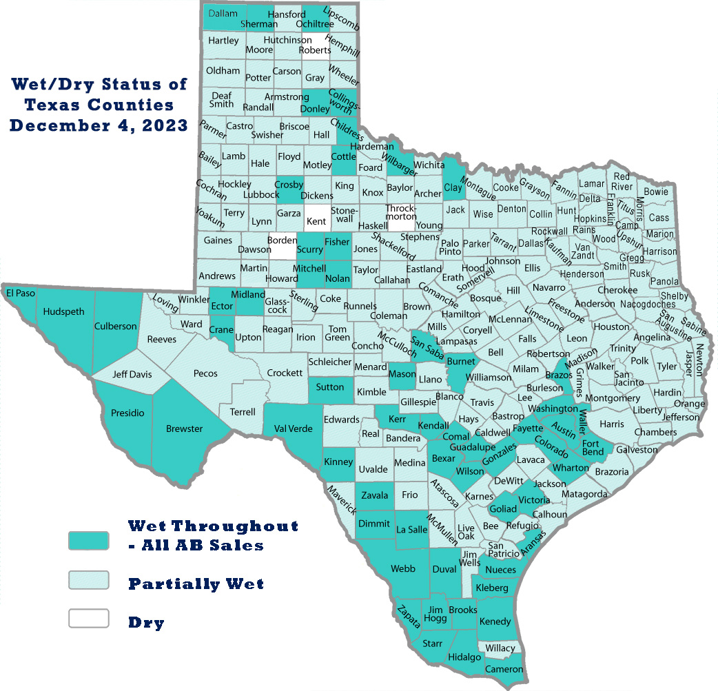
Scurry County is a county located in the U.S. state of Texas. As of the 2020 census, its population was 16,932. Its county seat is Snyder, which is the home for Western Texas College. Scurry County is named for Confederate General William Scurry. The county was created in 1876 and organized in 1884. Scurry County was one of 46 prohibition, or entirely dry, counties in the state of Texas, until a 2006 election approved the sale of beer and wine in Snyder, and a 2008 election approved the sale of liquor by the drink throughout the county.

<span class="mw-page-title-main">Parmer County, Texas</span> County in Texas, United States

Parmer County is a county located in the southwestern Texas Panhandle on the High Plains of the Llano Estacado in the U.S. state of Texas. As of the 2020 Census, the population was 9,869. The county seat is Farwell. The county was created in 1876 and later organized in 1907. It is named in honor of Martin Parmer, a signer of the Texas Declaration of Independence and early judge. Parmer County was one of 10 prohibition, or entirely dry, counties in the state of Texas, but is now a wet county.

<span class="mw-page-title-main">Midland County, Texas</span> County in Texas, United States

Midland County is a county located in the U.S. state of Texas. As of 2020, the population was 169,983. The county seat is Midland. The county is so named for being halfway (midway) between Fort Worth and El Paso on the Texas and Pacific Railway. Midland County is included in the Midland, TX Metropolitan Statistical Area as well as the Midland–Odessa Combined Statistical Area.

<span class="mw-page-title-main">Menard County, Texas</span> County in Texas, United States

Menard County is a county located on the Edwards Plateau in the U.S. state of Texas. As of the 2020 census, its population was 1,962. The county seat is Menard. The county was created in 1858 and later organized in 1871. It is named for Michel Branamour Menard, the founder of Galveston, Texas.

<span class="mw-page-title-main">Martin County, Texas</span> County in Texas, United States

Martin County is a county in the U.S. state of Texas. As of the 2020 census, its population was 5,237. Its county seat is Stanton. The county was created in 1876 and organized in 1884. It is named for Wylie Martin, an early settler.

<span class="mw-page-title-main">Howard County, Texas</span> County in Texas, United States

Howard County is a county located in the U.S. state of Texas. At the 2020 census, its population was 34,860. Its county seat is Big Spring. The county was created in 1876 and organized in 1882. It is named for Volney E. Howard, a U.S. Congressman from Texas.

<span class="mw-page-title-main">Hansford County, Texas</span> County in Texas, United States

Hansford County is a county located in the U.S. state of Texas. As of the 2020 census, its population was 5,285. Its county seat is Spearman. The county was created in 1876 and organized in 1889. It is named for John M. Hansford, a Texas state congressman and judge.

<span class="mw-page-title-main">Hall County, Texas</span> County in Texas, United States

Hall County is a county located in the U.S. state of Texas. As of the 2020 census, the population is 2,825. Its county seat is Memphis. The county was created in 1876 and later organized in 1890. It is named for Warren D. C. Hall, a secretary of war for the Republic of Texas.

<span class="mw-page-title-main">Foard County, Texas</span> County in Texas, United States

Foard County is a county located in the U.S. state of Texas. As of the 2020 census, its population was 1,095. Its county seat is Crowell, which is also the county's only incorporated community. The county is named for Robert Levi Foard, an attorney who served as a major with the Confederate Army, in the American Civil War.

<span class="mw-page-title-main">Fisher County, Texas</span> County in Texas, United States

Fisher County is a county located in the U.S. state of Texas. As of the 2020 census, its population was 3,672. The county seat is Roby. The county was created in 1876 and later organized in 1886. It is named for Samuel Rhoads Fisher, a signer of the Texas Declaration of Independence and a Secretary of the Navy of the Republic of Texas. Fisher County was one of 30 prohibition, or entirely dry, counties in Texas, but is now a fully wet county.

<span class="mw-page-title-main">Ector County, Texas</span> County in Texas, United States

Ector County is a county located in the U.S. state of Texas. In the 2020 census, its population was 165,171. Its county seat is Odessa. The county was founded in 1887 and organized in 1891. It is named for Matthew Ector, a Confederate general in the American Civil War.

<span class="mw-page-title-main">Dickens County, Texas</span> County in Texas, United States

Dickens County is a county located in the U.S. state of Texas. As of the 2020 census, its population was 1,770. Its county seat is Dickens. The county was created in 1876 and later organized in 1891. Both the county and its seat are named for J. Dickens, who died at the Battle of the Alamo.

<span class="mw-page-title-main">Dawson County, Texas</span> County in Texas, United States

Dawson County is a county in the U.S. state of Texas. As of the 2020 census, its population was 12,456. The county seat is Lamesa. The county was created in 1876 and later organized in 1905. It is named for Nicholas Mosby Dawson, a soldier of the Texas Revolution. Dawson County comprises the Lamesa, TX Micropolitan Statistical Area (μSA), and it is, by population, the smallest Micropolitan Statistical Area in the United States.

<span class="mw-page-title-main">Crosby County, Texas</span> County in Texas, United States

Crosby County is a county located in the U.S. state of Texas. As of the 2020 census, its population was 5,133. The county seat is Crosbyton. The county was founded in 1876 and later organized in 1886. Both the county and its seat are named for Stephen Crosby, a land commissioner in Texas.

<span class="mw-page-title-main">Cottle County, Texas</span> County in Texas, United States

Cottle County is a county in the U.S. state of Texas. As of the 2020 census, its population was 1,380. Its county seat is Paducah. The county was founded in 1876 and later organized in 1892. It is named for George Washington Cottle, who died defending the Alamo. Cottle County was formerly one of 46 prohibition, or entirely dry counties in the state of Texas. It now allows beer and wine sales.

<span class="mw-page-title-main">Collingsworth County, Texas</span> County in Texas, United States

Collingsworth County is a county in the U.S. state of Texas. As of the 2020 census, its population was 2,652. Its county seat is Wellington. The county was created in 1876 and later organized in 1890. It is named for James Collinsworth, a signer of the Texas Declaration of Independence and first chief justice of the Republic of Texas. Collingsworth County was one of 30 prohibition, or entirely dry, counties in Texas, but a vote in 2017 changed this law.

<span class="mw-page-title-main">Callahan County, Texas</span> County in Texas, United States

Callahan County is a county located in the U.S. state of Texas. As of the 2020 census, the population was 13,708. Its county seat is Baird. The county was founded in 1858 and later organized in 1877. It is named for James Hughes Callahan, an American soldier in the Texas Revolution. Callahan County is included in the Abilene, Texas metropolitan statistical area.

<span class="mw-page-title-main">Briscoe County, Texas</span> County in Texas, United States

Briscoe County is a county located in the U.S. state of Texas. As of the 2020 census, the population was 1,435. Its county seat is Silverton. The county was created in 1876 and later organized in 1892. It is named for Andrew Briscoe, a soldier during the Texas Revolution.

<span class="mw-page-title-main">Girard, Texas</span> Census-designated place in Texas, United States of America

Girard is an unincorporated community and census-designated place (CDP) in Kent County, Texas, United States. The population was 50 at the 2010 census.

<span class="mw-page-title-main">Jayton, Texas</span> City in Texas, United States

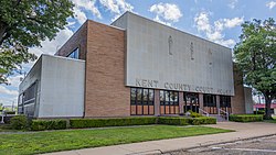
Jayton is a city in and the county seat of Kent County, Texas, United States. It is located in the northeastern portion of the county, and the population was 511 as of the 2020 census.

References

  1. 1 2 "State & County QuickFacts". United States Census Bureau. Retrieved December 17, 2023.
  2. "Find a County". National Association of Counties. Archived from the original on May 31, 2011. Retrieved June 7, 2011.
  3. "Texas: Individual County Chronologies". Texas Atlas of Historical County Boundaries. The Newberry Library. 2008. Archived from the original on April 12, 2017. Retrieved May 24, 2015.
  4. "Texas counties wet/dry status as of May 2020" (Spreadsheet). Texas.gov.
  5. "We/Dry Status of Texas Counties". June 1, 2023.
  6. 1 2 3 4 5 6 7 8 Hunt, William R (June 15, 2010). "Kent County, Texas". Handbook of Texas Online. Texas State Historical Association. Retrieved December 16, 2010.
  7. Davis, Charles G (June 12, 2010). "Clairmont". Handbook of Texas Online. Texas State Historical Association. Retrieved December 16, 2010.
  8. "Clairemont, Texas". Texas Escapes. Texas Escapes - Blueprints For Travel, LLC. Retrieved December 16, 2010.
  9. Davis, Charles G (June 15, 2010). "Jayton, Texas". Handbook of Texas Online. Texas State Historical Association. Retrieved December 16, 2010.
  10. "2010 Census Gazetteer Files". United States Census Bureau. August 22, 2012. Retrieved May 2, 2015.
  11. "Annual Estimates of the Resident Population for Counties: April 1, 2020 to July 1, 2022" . Retrieved December 17, 2023.
  12. "U.S. Decennial Census". United States Census Bureau. Retrieved March 26, 2015.
  13. "Texas Almanac: Population History of Counties from 1850–2010" (PDF). Texas Almanac. Archived (PDF) from the original on October 9, 2022. Retrieved May 2, 2015.
  14. "P2 HISPANIC OR LATINO, AND NOT HISPANIC OR LATINO BY RACE - 2010: DEC Redistricting Data (PL 94-171) - Kent County, Texas". United States Census Bureau .
  15. "P2 HISPANIC OR LATINO, AND NOT HISPANIC OR LATINO BY RACE - 2020: DEC Redistricting Data (PL 94-171) - Kent County, Texas". United States Census Bureau .
  16. "U.S. Census website". United States Census Bureau . Retrieved May 14, 2011.
  17. "State Rep. Springer announces district tour July 30". Lubbock Avalanche-Journal, July 16, 2013. Retrieved July 18, 2013.
  18. Leip, David. "Dave Leip's Atlas of U.S. Presidential Elections". uselectionatlas.org. Retrieved July 26, 2018.

33°11′N100°46′W / 33.19°N 100.77°W / 33.19; -100.77