Duval County, Texas

Last updated

Duval County
Duval courthouse.jpg
The Duval County Courthouse in San Diego
Map of Texas highlighting Duval County.svg
Location within the U.S. state of Texas
Texas in United States.svg
Texas's location within the U.S.
Coordinates: 27°41′N98°31′W / 27.68°N 98.52°W / 27.68; -98.52
CountryFlag of the United States.svg United States
StateFlag of Texas.svg  Texas
Founded1876
Named for Burr H. Duval
Seat San Diego
Largest citySan Diego
Area
  Total1,796 sq mi (4,650 km2)
  Land1,793 sq mi (4,640 km2)
  Water2.1 sq mi (5 km2)  0.1%
Population
 (2020)
  Total9,831
  Density5.5/sq mi (2.1/km2)
Time zone UTC−6 (Central)
  Summer (DST) UTC−5 (CDT)
Congressional district 28th
Website www.co.duval.tx.us

Duval County is a county located in the U.S. state of Texas. As of the 2020 census, its population was 9,831. [1] [2] The county seat is San Diego. [3] The county was founded in 1858 and later organized in 1876. [4] It is named for Burr H. Duval, a soldier in the Texas Revolution who died in the Goliad Massacre.

Contents

History

Duval County's development began during the Viceroyalty of New Spain (1521–1821). In 1804, six years before Father Miguel Hidalgo y Costilla launched Mexico's successful independence movement from Spain, Jose Faustino Contreras, surveyor general of San Luis Potosi, charted the county's landscape, which attracted colonists from Mier, Tamaulipas.

On February 1, 1858, the Texas Legislature established Duval County. The Texas Almanac of 1867 reported that Duval and nearby Dimmit County had only four stock raisers and their population was unlikely to grow much, absent the discovery of mineral wealth. Not long after, a wave of Anglo immigrants entered the county to raise sheep. Englishmen, Frenchmen, Germans, Irishmen, and Scots came. During this boom, the county seat enjoyed formal balls and haute cuisine. The Hotel Martinet's Sunday feast drew patrons from Corpus Christi, 50 miles (80 km) to the East.

The death rate rivaled Tombstone, Arizona's. Although some died under the code duello, most of Duval County's deaths were murders that primarily victimized the legacy Spanish-speaking population. When a great pile of cowhides presumed to have come from stolen animals was discovered near the county line, a vigilante group from Duval and McMullen County lynched 15 Spanish-speaking Texans there.

Prosperity in the 1880s placated Anglo animosity. When the Texas Mexican Railway began operating in 1881, its San Diego station served as an important hub for trading hides, wool and cotton, but the boom evaporated when sheep began dying during the Winter of 1886–1887, triggering the Sheep Wars that once again primarily victimized the legacy Spanish-speaking population.

During the twentieth century, the Parr family established a political machine that dominated politics in Duval and nearby Jim Wells counties. The family was instrumental in the 1948 election of Lyndon B. Johnson to the US Senate, [5] [6] and influenced the outcome of the 1960 presidential election which threw Texas to John F. Kennedy. [7]

Geography

State Highway 16, Duval County, Texas, USA. (April 16, 2016) State Highway 16, Duval County, Texas, USA. (16 April 2016).jpg
State Highway 16, Duval County, Texas, USA. (April 16, 2016)

According to the U.S. Census Bureau, the county has a total area of 1,796 square miles (4,650 km2), of which 1,793 square miles (4,640 km2) is land and 2.1 square miles (5.4 km2) (0.1%) is water. [8] The county overlies the Piedras Pintas salt dome, [9] [10] scheduled for at hydrogen storage. [11]

Major highways

Adjacent counties

Demographics

Historical population
CensusPop.Note
1870 1,083
1880 5,732429.3%
1890 7,59832.6%
1900 8,48311.6%
1910 8,9645.7%
1920 8,251−8.0%
1930 12,19147.8%
1940 20,56568.7%
1950 15,643−23.9%
1960 13,398−14.4%
1970 11,722−12.5%
1980 12,5176.8%
1990 12,9183.2%
2000 13,1201.6%
2010 11,782−10.2%
2020 9,831−16.6%
U.S. Decennial Census [12]
1850–2010 [13] 2010 [14] 2020 [15]
Duval County, Texas - Demographic Profile
(NH = Non-Hispanic)
Race / EthnicityPop 2010 [14] Pop 2020 [15] % 2010% 2020
White alone (NH)1,20693710.24%9.53%
Black or African American alone (NH)861450.73%1.47%
Native American or Alaska Native alone (NH)18130.15%0.13%
Asian alone (NH)17450.14%0.46%
Pacific Islander alone (NH)500.04%0.00%
Some Other Race alone (NH)680.05%0.08%
Mixed Race/Multi-Racial (NH)207210.17%7.33%
Hispanic or Latino (any race)10,4247,96288.47%80.99%
Total11,7829,831100.00%100.00%

Note: the US Census treats Hispanic/Latino as an ethnic category. This table excludes Latinos from the racial categories and assigns them to a separate category. Hispanics/Latinos can be of any race.

As of the 2010 United States census, there were 11,782 people living in the county. 87.0% were White, 0.9% Black or African American, 0.4% Native American, 0.2% Asian, 9.8% of some other race and 1.7% of two or more races. 88.5% were Hispanic or Latino (of any race).

As of the census [16] of 2000, there were 13,120 people, 4,350 households, and 3,266 families living in the county. The population density was 7 people per square mile (2.7 people/km2). There were 5,543 housing units at an average density of 3 units per square mile (1.2/km2). The racial makeup of the county was 80.22% White, 0.54% Black or African American, 0.53% Native American, 0.11% Asian, 0.03% Pacific Islander, 15.46% from other races, and 3.11% from two or more races. 87.99% of the population were Hispanic or Latino of any race.

There were 4,350 households, out of which 36.80% had children under the age of 18 living with them, 53.20% were married couples living together, 16.80% had a female householder with no husband present, and 24.90% were non-families. 22.90% of all households were made up of individuals, and 11.70% had someone living alone who was 65 years of age or older. The average household size was 2.88 and the average family size was 3.40.

In the county, the population was spread out, with 29.50% under the age of 18, 9.50% from 18 to 24, 26.40% from 25 to 44, 20.60% from 45 to 64, and 14.00% who were 65 years of age or older. The median age was 34 years. For every 100 females there were 100.70 males. For every 100 females age 18 and over, there were 102.90 males.

The median income for a household in the county was $22,416, and the median income for a family was $26,014. Males had a median income of $25,601 versus $16,250 for females. The per capita income for the county was $11,324. About 23.00% of families and 27.20% of the population were below the poverty line, including 35.90% of those under age 18 and 25.30% of those age 65 or over.

Politics

Duval County is a Democratic stronghold like most of heavily Hispanic South Texas. The last Republican to carry the county was Theodore Roosevelt in 1904. [17] In the 1964, [18] 1968 [19] and 1972 presidential elections, Duval was the most Democratic county in the country. [20] In the 2004 presidential election, the county voted for Democrat John F. Kerry of Massachusetts by a strong margin despite George W. Bush's 22.87 percent margin of victory in the state. From 1956 to 2012, the Democratic candidate consistently received more than seventy percent of the county's vote. After 2012, the county's voters began to trend towards the Republican Party; the Democratic margin of victory decreased by 18.9 percentage points from 2012 to 2016, and by 32.6 percentage points from 2016 to 2020, with 2020 Democratic presidential nominee Joe Biden winning the county by only 2.6 percent, the worst-ever Democratic performance in the county.

United States presidential election results for Duval County, Texas [21]
Year Republican Democratic Third party
No.%No.%No.%
2020 2,44348.35%2,57550.96%350.69%
2016 1,31631.57%2,78366.77%691.66%
2012 98022.56%3,33176.68%330.76%
2008 1,07624.40%3,29874.80%350.79%
2004 1,16028.35%2,91671.28%150.37%
2000 1,01020.08%3,99079.32%300.60%
1996 54311.65%3,95884.94%1593.41%
1992 69813.86%4,00679.56%3316.57%
1988 90717.79%4,17781.95%130.26%
1984 1,20124.22%3,74875.58%100.20%
1980 1,01221.27%3,70677.91%390.82%
1976 66113.38%4,26786.36%130.26%
1972 62314.32%3,72985.68%00.00%
1968 3848.57%3,97888.74%1212.70%
1964 3537.37%4,43292.55%40.08%
1960 80917.53%3,80382.42%20.04%
1956 1,45931.89%3,11067.98%60.13%
1952 67216.85%3,31683.13%10.03%
1948 1173.18%3,55196.52%110.30%
1944 1363.87%3,35395.31%290.82%
1940 1514.46%3,23295.51%10.03%
1936 1635.31%2,90194.56%40.13%
1932 301.88%1,56698.12%00.00%
1928 43425.85%1,24574.15%00.00%
1924 898.42%94789.59%211.99%
1920 867.33%1,08192.08%70.60%
1916 375.81%59793.72%30.47%
1912 00.00%91599.03%90.97%

After the initial election returns in the 1948 Democrat runoff primary election for U.S. Senate, Duval County added 425 votes for Lyndon B. Johnson over Coke R. Stevenson. (George Parr simultaneously arranged the more famous electoral fraud for Johnson in Alice, Texas.) [22]

Duval County is notorious for corrupt politics, particularly during the early and mid-20th century, when it was largely controlled by the political machine of Texas State Senator Archie Parr and his son George Parr, each in his turn called El Patrón or the "Duke of Duval". [23] Givens Parr had been county judge before his younger brother George. George was later elected sheriff. Archer Parr III, George's nephew and adopted brother, later held both those offices. [24] Meanwhile, then Texas Attorney General John Ben Shepperd brought some three hundred state indictments against county and school officials.

Communities

Cities

Census-designated places

Unincorporated communities

Ghost towns

Education

School districts for the county include:

Coastal Bend College (formerly Bee County College) is the designated community college for the county. [25]

See also

Related Research Articles

<span class="mw-page-title-main">Montgomery County, Texas</span> County in Texas, United States

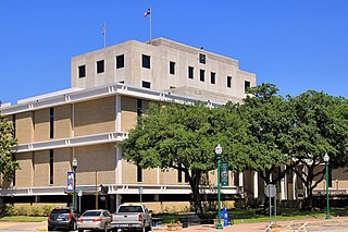
Montgomery County is a county in the U.S. state of Texas. As of the 2020 U.S. census, the county had a population of 620,443. The county seat is Conroe. The county was created by an act of the Congress of the Republic of Texas on December 14, 1837, and is named for the town of Montgomery. Between 2000 and 2010, its population grew by 55%, the 24th-fastest rate of growth of any county in the United States. Between 2010 and 2020, its population grew by 36%. According to the U.S. Census Bureau, the estimated population is 711,354 as of July 1, 2023.

<span class="mw-page-title-main">Wise County, Texas</span> County in Texas, United States

Wise County is a county in the U.S. state of Texas. As of the 2020 census, its population was 68,632. Its county seat is Decatur. Wise County is part of the Dallas–Fort Worth–Arlington metropolitan statistical area. Its Wise Eyes crime-watch program, eventually adopted by mostly rural counties in several states, was started in 1993 by then-Sheriff Phil Ryan.

<span class="mw-page-title-main">Washington County, Texas</span> County in Texas, United States

Washington County is a county in Texas. As of the 2020 census, the population was 35,805. Its county seat is Brenham, which is located along U.S. Highway 290, 72 miles northwest of Houston. The county was created in 1835 as a municipality of Mexico and organized as a county in 1837. It is named for George Washington, the first president of the United States.

<span class="mw-page-title-main">Parker County, Texas</span> County in Texas, United States

Parker County is a county located in the U.S. state of Texas. As of the 2020 census, its population was 148,222. The county seat is Weatherford. The county was created in 1855 and organized the following year. It is named for Isaac Parker, a state legislator who introduced the bill that established the county in 1855. Parker later fought in the Texas Brigade.

<span class="mw-page-title-main">Ochiltree County, Texas</span> County in Texas, United States

Ochiltree County is a county located in the panhandle of the U.S. state of Texas. As of the 2020 census, its population was 10,015. The county seat is Perryton. The county was created in 1876 and organized in 1889. and is named for William Beck Ochiltree, who was an attorney general of the Republic of Texas. It was previously one of 30 prohibition or entirely dry counties in the state of Texas.

<span class="mw-page-title-main">Nueces County, Texas</span> County in Texas, United States

Nueces County is located in the U.S. state of Texas. As of the 2020 census, the population was 353,178, making it the 16th-most populous county in the state. The county seat is Corpus Christi. The county was formed in 1846 from portions of San Patricio County and organized the following year. It is named for the Nueces River, which marks the county's northwestern boundary with San Patricio County before emptying into its mouth at Nueces Bay north of the port of Corpus Christi. Nueces County is part of the Corpus Christi metropolitan statistical area.

<span class="mw-page-title-main">Newton County, Texas</span> County in Texas, United States

Newton County is the easternmost county in the U.S. state of Texas. As of the 2020 census, its population was 12,217. Its county seat is Newton. The county is named for John Newton, a veteran of the American Revolutionary War.

<span class="mw-page-title-main">Midland County, Texas</span> County in Texas, United States

Midland County is a county located in the U.S. state of Texas. As of 2020, the population was 169,983. The county seat is Midland. The county is so named for being halfway (midway) between Fort Worth and El Paso on the Texas and Pacific Railway. Midland County is included in the Midland, TX Metropolitan Statistical Area as well as the Midland–Odessa Combined Statistical Area.

<span class="mw-page-title-main">McMullen County, Texas</span> County in Texas, United States

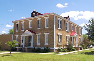
McMullen County is a county located in the U.S. state of Texas. As of the 2020 census, its population was 600, making it the fourth-least populous county in Texas. Its county seat is Tilden. The county was established from parts of Bexar County, Atascosa County, and Live Oak County in 1858 and later organized in 1877. It is named for John McMullen, founder of a colony in Texas. The McMullen County Courthouse was designed by the architect W.C. Stephenson, originally from Buffalo, New York. Stephenson also designed some 50 buildings in Beeville, including the Bee County Courthouse.

<span class="mw-page-title-main">Live Oak County, Texas</span> County in Texas, United States

Live Oak County is a county in the U.S. state of Texas. It was named for its native groves of live oak. George West is its county seat. Its population was 11,335 in the 2020 census.

<span class="mw-page-title-main">Lee County, Texas</span> County in Texas, United States

Lee County is a county located in the U.S. state of Texas. As of the 2020 census, its population was 17,478. Its county seat is Giddings. The county was founded in 1874 and is named for Confederate General Robert E. Lee. The county has many Confederate memorials and monuments to the Confederate States of America.

<span class="mw-page-title-main">King County, Texas</span> County in Texas, United States

King County is a county located in the U.S. state of Texas. The population was 265 at the 2020 census, making it the second-least populated county in Texas and the third-least populated county in the United States. King County has no incorporated communities. Its county seat is the census-designated place (CDP) of Guthrie. The county was created in 1876 and organized in 1891. It is named for William Philip King, who died at the Battle of the Alamo.

<span class="mw-page-title-main">Jim Wells County, Texas</span> County in Texas, United States

Jim Wells County is a county in the U.S. state of Texas. As of the 2020 census, its population was 38,891. The county was founded in 1911 and is named for James B. Wells Jr. (1850–1923), for three decades a judge and Democratic Party political boss in South Texas.

<span class="mw-page-title-main">Jim Hogg County, Texas</span> County in Texas, United States

Jim Hogg County is a county located in the U.S. state of Texas. As of the 2020 census, the population was 4,838. Its county seat is Hebbronville. The county is named for James Stephen Hogg, the governor of Texas from 1891 to 1895.

<span class="mw-page-title-main">Hays County, Texas</span> County in Texas, United States

Hays County is a county in the central portion of the U.S. state of Texas. It is part of the Austin-Round Rock metropolitan area. As of the 2020 census, its official population had reached 241,067. The county seat is San Marcos. Hays, along with Comal and Kendall Counties, was listed in 2017 as one of the nation's fastest-growing counties with a population of at least 10,000. From 2015 to 2016, Hays County, third on the national list, had nearly 10,000 new residents during the year.

<span class="mw-page-title-main">Glasscock County, Texas</span> County in Texas, United States

Glasscock County is a county located in the U.S. state of Texas. As of the 2020 census, its population was 1,169. Its county seat is Garden City. The county was created in 1827 and later organized in 1869. It is named for George Washington Glasscock, an early settler of the Austin, Texas area and the namesake of Georgetown, Texas.

<span class="mw-page-title-main">Cottle County, Texas</span> County in Texas, United States

Cottle County is a county in the U.S. state of Texas. As of the 2020 census, its population was 1,380. Its county seat is Paducah. The county was founded in 1876 and later organized in 1892. It is named for George Washington Cottle, who died defending the Alamo. Cottle County was formerly one of 46 prohibition, or entirely dry counties in the state of Texas. It now allows beer and wine sales.

<span class="mw-page-title-main">Cooke County, Texas</span> County in Texas, United States

Cooke County is a county in the U.S. state of Texas. At the 2020 census, its population was 41,668. The county seat is Gainesville. The county was founded in 1848 and organized the next year. It is named for William Gordon Cooke, a soldier during the Texas Revolution. It is a part of the Texoma region.

<span class="mw-page-title-main">Greene County, North Carolina</span> County in North Carolina, United States

Greene County is a county located in the U.S. state of North Carolina. As of the 2020 census, the population was 20,451. Its county seat is Snow Hill.

George Berham Parr was an American politician, who controlled a Democratic political machine that dominated Duval County, Texas and, to a lesser extent, Jim Wells County. He was known as "The Duke of Duval," like his father before him.

References

  1. "U.S. Census Bureau QuickFacts: Duval County, Texas". United States Census Bureau. Retrieved January 31, 2022.
  2. "Duval County, Texas". United States Census Bureau . Retrieved February 23, 2021.
  3. "Find a County". National Association of Counties. Archived from the original on July 12, 2012. Retrieved June 7, 2011.
  4. "Texas: Individual County Chronologies". Texas Atlas of Historical County Boundaries. The Newberry Library. 2008. Archived from the original on May 13, 2015. Retrieved May 21, 2015.
  5. Lynch, Dudley M. (January 1, 1976). The Duke of Duval: The Life and Times of George B. Parr. Waco: Texian Press. pp 8-10. ISBN   978-0-87244-044-9. LCCN 76-54438. Retrieved September 9, 2013.
  6. Caro, Robert (1990). The Years of Lyndon Johnson: Means of Ascent. Alfred A. Knopf. ISBN   978-0394528359.
  7. Caro, Robert (2012). The Years of Lyndon Johnson: The Passage of Power. Alfred A. Knopf. ISBN   978-0375713255.
  8. "2010 Census Gazetteer Files". United States Census Bureau. August 22, 2012. Retrieved April 22, 2015.
  9. "Piedras Pintas, Duval Co., Texas, USA". www.mindat.org.
  10. Barton, DC (1925). "The Salt Domes of South Texas" (PDF). GeoScienceWorld. Archived (PDF) from the original on October 9, 2022.
  11. Collins, Leigh (March 3, 2022). "World's largest green hydrogen project unveiled in Texas, with plan to produce clean rocket fuel for Elon Musk | Recharge". Recharge | Latest renewable energy news.
  12. "Decennial Census of Population and Housing by Decade". US Census Bureau.
  13. "Texas Almanac: Population History of Counties from 1850–2010" (PDF). Texas Almanac. Archived (PDF) from the original on October 9, 2022. Retrieved April 22, 2015.
  14. 1 2 "P2 HISPANIC OR LATINO, AND NOT HISPANIC OR LATINO BY RACE - 2010: DEC Redistricting Data (PL 94-171) - Duval County, Texas". United States Census Bureau .
  15. 1 2 "P2 HISPANIC OR LATINO, AND NOT HISPANIC OR LATINO BY RACE - 2020: DEC Redistricting Data (PL 94-171) - Duval County, Texas". United States Census Bureau .
  16. "U.S. Census website". United States Census Bureau . Retrieved May 14, 2011.
  17. "Presidential election of 1904 - Map by counties". géographie électorale. Retrieved October 2, 2013.
  18. "1964 Presidential Election Statistics". Dave Leip's Atlas of U.S. Presidential Elections. Retrieved June 20, 2017.
  19. "1968 Presidential Election Statistics". Dave Leip's Atlas of U.S. Presidential Elections. Retrieved June 20, 2017.
  20. "1972 Presidential Election Statistics". Dave Leip's Atlas of U.S. Presidential Elections. Retrieved October 2, 2013.
  21. Leip, David. "Dave Leip's Atlas of U.S. Presidential Elections". uselectionatlas.org. Retrieved July 22, 2018.
  22. Givens, Murphy (September 7, 2011). "George Parr inherited his father's political dynasty". Corpus Christi Caller Times . Retrieved April 13, 2013. Stevenson also challenged the results in Duval County, where the vote totals also changed dramatically after the election. On election night in Duval County, the county chairman reported Johnson with 4,187 votes, Stevenson with 38. Six days later, the official canvass increased that to 4,622 votes for Johnson, 40 for Stevenson. Johnson gained 425 votes and Stevenson 2.
  23. Givens, Murphy (August 31, 2011). "Cowboy from Matagorda founded political dynasty". Corpus Christi Caller Times. Retrieved April 13, 2013.
  24. Lynch, Dudley M. (January 1, 1976). The Duke of Duval: The Life and Times of George B. Parr. Waco: Texian Press. pp. 31, 34, 90, 127. ISBN   978-0-87244-044-9. LCCN   76-54438 . Retrieved September 9, 2013.
  25. Texas Education Code Sec. 130.167. BEE COUNTY COLLEGE DISTRICT SERVICE AREA. The legislation calls it "Bee County College".

27°41′N98°31′W / 27.68°N 98.52°W / 27.68; -98.52