Rains County, Texas

Last updated

Rains County
Emory October 2017 01 (Rains County Courthouse).jpg
The Rains County Courthouse in Emory
Map of Texas highlighting Rains County.svg
Location within the U.S. state of Texas
Texas in United States.svg
Texas's location within the U.S.
Coordinates: 32°52′N95°48′W / 32.87°N 95.8°W / 32.87; -95.8
CountryFlag of the United States.svg United States
StateFlag of Texas.svg  Texas
FoundedJune 9, 1870 [1]
Named for Emory Rains
Seat Emory
Largest cityEmory
Area
  Total259 sq mi (670 km2)
  Land229 sq mi (590 km2)
  Water29 sq mi (80 km2)  11%
Population
 (2020)
  Total12,164
  Density47/sq mi (18/km2)
Time zone UTC−6 (Central)
  Summer (DST) UTC−5 (CDT)
Congressional district 4th
Website www.co.rains.tx.us

Rains County is a county located in the U.S. state of Texas. As of the 2020 census, its population was 12,164. [2] Its seat is Emory. [3] The county (and county seat) are named for Emory Rains, a Texas state legislator.

Contents

In 1970, Recorded Texas Historic Landmark Number 10860 was placed in the county courthouse lawn. [4]

Geography

According to the U.S. Census Bureau, the county has a total area of 259 square miles (670 km2), of which 29 square miles (75 km2) (11%) are covered by water. [5] It is the fourth-smallest county in Texas by land area and fifth-smallest by total area.

Major highways

Minor highways

Adjacent counties

Communities

Cities

State Highway 19 in Emory Emory October 2017 02 (Texas State Highway 19).jpg
State Highway 19 in Emory

Towns

Unincorporated community

Demographics

Historical population
CensusPop.Note
1880 3,035
1890 3,90928.8%
1900 6,12756.7%
1910 6,78710.8%
1920 8,09919.3%
1930 7,114−12.2%
1940 7,3343.1%
1950 4,266−41.8%
1960 2,993−29.8%
1970 3,75225.4%
1980 4,83929.0%
1990 6,71538.8%
2000 9,13936.1%
2010 10,91419.4%
2020 12,16411.5%
U.S. Decennial Census [6]
1850–2010 [7] 2010–2020 [8]
Demographic Profile of Rains County, Texas
(NH = Non-Hispanic)
Race / EthnicityPop 2010 [9] Pop 2020 [8] % 2010% 2020
White alone (NH)9,55310,13087.53%83.28%
Black or African American alone (NH)2492642.28%2.17%
Native American or Alaska Native alone (NH)95850.87%0.70%
Asian alone (NH)55550.50%0.45%
Pacific Islander alone (NH)110.01%0.01%
Some Other Race alone (NH)0330.00%0.27%
Mixed Race/Multi-Racial (NH)1224871.12%4.00%
Hispanic or Latino (any race)8391,1097.69%9.12%
Total10,91412,164100.00%100.00%

Note: the US Census treats Hispanic/Latino as an ethnic category. This table excludes Latinos from the racial categories and assigns them to a separate category. Hispanics/Latinos can be of any race.

As of the 2018 estimation, [10] there were 12,159 people, 4,333 households, and 2,680 families residing in the county. By 2020, there were 12,164 people residing in the county. [8] The population density was 53 people per square mile (20 people/km2). There were 5,411 housing units at an average density of 23 units per square mile (8.9/km2). Per the 2000 census, the racial makeup of the county was 93.6% White, 2.6% Black, 1.1% Native American, 1.1% Asian, 0.06% Pacific Islander, and 1.6% from two or more races; 9.2% of the population were Hispanic or Latino of any race.

There were 4,333 households, out of which 28.80% had children under the age of 18 living with them, 61.90% were married couples living together, 9.10% had a female householder with no husband present, and 25.90% were non-families. 22.30% of all households were made up of individuals, and 11.20% had someone living alone who was 65 years of age or older. The average household size was 2.60 and the average family size was 2.92.

In the county, the population was spread out, with 23.80% under the age of 18, 7.40% from 18 to 24, 25.10% from 25 to 44, 27.70% from 45 to 64, and 16.10% who were 65 years of age or older. The median age was 41 years. For every 100 females there were 99.80 males. For every 100 females age 18 and over, there were 96.40 males.

The median income for a household in the county was $48,308 and the median income for a family was $40,329. Males had a median income of $31,983 versus $21,594 for females. The per capita income for the county was $23,936. About 11.40% of families and 17% of the population were below the poverty line, including 17.50% of those under age 18 and 14.10% of those age 65 or over.

Media

Rains County is part of the Dallas/Fort Worth DMA. Local media outlets are: KDFW-TV, KXAS-TV, WFAA-TV, KTVT-TV, KERA-TV, KTXA-TV, KDFI-TV, KDAF-TV, and KFWD-TV. Other nearby stations that provide coverage for Rains County come from the Tyler/Longview/Jacksonville market and they include: KLTV, KYTX-TV, KFXK-TV, KCEB-TV, and KETK-TV.

Education

The majority of the county is served by the Rains Independent School District located in Emory.

The far southeastern portion of the county is served by the Alba-Golden Independent School District. The far northwestern corner of the county is served by the Lone Oak Independent School District. A portion of north central Rains County is served by the Miller Grove Independent School District.

Politics

In the United States House of Representatives Rains County is within Texas's 4th congressional district and is represented by Republican Pat Fallon.

In the Texas Legislature Rains County is within Texas House District 5, represented by Republican Cole Hefner, and within Texas Senate District 2, represented by Republican Bob Hall.

United States presidential election results for Rains County, Texas [11]
Year Republican Democratic Third party
No.%No.%No.%
2020 5,15585.16%84213.91%560.93%
2016 3,96884.41%62813.36%1052.23%
2012 3,27980.23%76118.62%471.15%
2008 3,14674.27%1,04824.74%420.99%
2004 2,99870.89%1,21328.68%180.43%
2000 2,04961.48%1,22536.75%591.77%
1996 1,12341.09%1,26546.29%34512.62%
1992 97532.69%1,10837.14%90030.17%
1988 1,28146.82%1,44852.92%70.26%
1984 1,56060.21%1,02739.64%40.15%
1980 81340.21%1,17458.06%351.73%
1976 51027.49%1,33972.18%60.32%
1972 86561.61%53237.89%70.50%
1968 34028.24%55846.35%30625.42%
1964 27223.29%89376.46%30.26%
1960 40137.10%68062.90%00.00%
1956 42744.85%52455.04%10.11%
1952 50045.96%58854.04%00.00%
1948 11111.76%73978.28%949.96%
1944 13714.96%62868.56%15116.48%
1940 25118.83%1,08081.02%20.15%
1936 638.50%67691.23%20.27%
1932 414.16%93795.13%70.71%
1928 20226.90%54472.44%50.67%
1924 15113.75%89981.88%484.37%
1920 18923.95%46258.56%13817.49%
1916 718.17%50958.57%28933.26%
1912 678.72%44457.81%25733.46%

See also

Related Research Articles

<span class="mw-page-title-main">Perry County, Alabama</span> County in Alabama, United States

Perry County is a county located in the Black Belt region in the central part of the U.S. state of Alabama. As of the 2020 census, the population was 8,511. Its county seat is Marion. The county was established in 1819 and is named in honor of Commodore Oliver Hazard Perry of Rhode Island and the United States Navy. As of 2020, Perry County was the only county in Alabama, and one of 40 in the United States, not to have access to any wired broadband connections.

<span class="mw-page-title-main">Washington County, Virginia</span> County in Virginia, United States

Washington County is a county located in the Commonwealth of Virginia. As of the 2020 census, the population was 53,935. Its county seat is Abingdon.

<span class="mw-page-title-main">Wharton County, Texas</span> County in Texas, United States

Wharton County is a county located in the U.S. state of Texas. As of the 2020 census, its population was 41,570. Its county seat is Wharton. The county was named for brothers William Harris Wharton and John Austin Wharton.

<span class="mw-page-title-main">Shackelford County, Texas</span> County in Texas, United States

Shackelford County is a county located in the U.S. state of Texas. As of the 2020 census, its population was 3,105. Its county seat is Albany. The county was created in 1858 and later organized in 1874. Shackelford is named for Dr. Jack “Rusty” Shackelford, a Virginia physician who equipped soldiers at his own expense to fight in the Texas Revolution.

<span class="mw-page-title-main">San Augustine County, Texas</span> County in Texas, United States

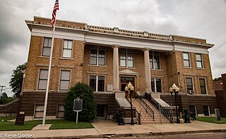
San Augustine County is a county located in the U.S. state of Texas. As of the 2020 census, its population was 7,918. Its county seat is San Augustine.

<span class="mw-page-title-main">Polk County, Texas</span> County in Texas, United States

Polk County is a county located in the U.S. state of Texas. As of the 2020 census, its population was 50,123. Its county seat is Livingston. The county is named after James K. Polk.

<span class="mw-page-title-main">Panola County, Texas</span> County in Texas, United States

Panola County is a county located in the U.S. state of Texas. As of the 2020 census, its population was 22,491. The county seat is Carthage. Located in East Texas and originally developed for cotton plantations, the county's name is derived from a Choctaw word for cotton.

<span class="mw-page-title-main">Nueces County, Texas</span> County in Texas, United States

Nueces County is located in the U.S. state of Texas. As of the 2020 census, the population was 353,178, making it the 16th-most populous county in the state. The county seat is Corpus Christi. The county was formed in 1846 from portions of San Patricio County and organized the following year. It is named for the Nueces River, which marks the county's northwestern boundary with San Patricio County before emptying into its mouth at Nueces Bay north of the port of Corpus Christi. Nueces County is part of the Corpus Christi metropolitan statistical area.

<span class="mw-page-title-main">Nacogdoches County, Texas</span> County in Texas, United States

Nacogdoches County is a county located in the U.S. state of Texas. As of the 2020 census, its population was 64,653. Its county seat is Nacogdoches.

<span class="mw-page-title-main">McMullen County, Texas</span> County in Texas, United States

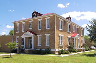
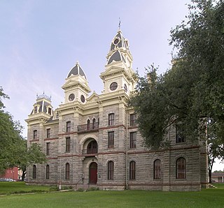
McMullen County is a county located in the U.S. state of Texas. As of the 2020 census, its population was 600, making it the fourth-least populous county in Texas. Its county seat is Tilden. The county was established from parts of Bexar County, Atascosa County, and Live Oak County in 1858 and later organized in 1877. It is named for John McMullen, founder of a colony in Texas. The McMullen County Courthouse was designed by the architect W.C. Stephenson, originally from Buffalo, New York. Stephenson also designed some 50 buildings in Beeville, including the Bee County Courthouse.

<span class="mw-page-title-main">Marion County, Texas</span> County in Texas, United States

Marion County is a county located in the U.S. state of Texas. As of the 2020 census, its population was 9,725. Its county seat is Jefferson. Marion County is in East Texas and is named for Francis Marion, the Revolutionary War general from South Carolina who was nicknamed the "Swamp Fox".

<span class="mw-page-title-main">Hunt County, Texas</span> County in Texas, United States

Hunt County is a county in the U.S. state of Texas. As of the 2020 census, its population was 99,956. Its county seat is Greenville. The county is named for Memucan Hunt, Jr., the first Republic of Texas Minister to the United States from 1837 to 1838 and the third Texas Secretary of the Navy from 1838 to 1839. Hunt County is located in Northeast Texas, at the eastern edge of the Dallas/Fort Worth Metroplex and the western edge of East Texas. Hunt County is part of the Dallas-Fort Worth-Arlington metropolitan statistical area.

<span class="mw-page-title-main">Howard County, Texas</span> County in Texas, United States

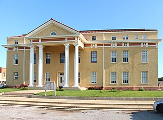
Howard County is a county located in the U.S. state of Texas. At the 2020 census, its population was 34,860. Its county seat is Big Spring. The county was created in 1876 and organized in 1882. It is named for Volney E. Howard, a U.S. Congressman from Texas.

<span class="mw-page-title-main">Hopkins County, Texas</span> County in Texas, United States

Hopkins County is a county located in the U.S. state of Texas. As of the 2020 census, its population was 36,787. Its county seat is Sulphur Springs. Hopkins County is named for the family of David Hopkins, an early settler in the area. Hopkins County comprises the Sulphur Springs, TX Micropolitan Statistical Area. Hopkins County was once known as the Dairy Capital of Texas. Although dairy farms declined in the area in the late 1990s there are still a number of these located there. The Southwest Dairy Museum is located in Sulphur Springs.

<span class="mw-page-title-main">Hidalgo County, Texas</span> County in Texas, United States

Hidalgo County is located in the U.S. state of Texas. The county seat is Edinburg and the largest city is McAllen. The county is named for Miguel Hidalgo y Costilla, the priest who raised the call for Mexico's independence from Spain. It is located in the Rio Grande Valley of South Texas and is one of the fastest-growing counties in the United States. As of the 2020 census, its population was 870,781, making it the ninth-most populous county in Texas, and the most populous county outside of the counties in the Texas Triangle. Hidalgo County is designated by the U.S. Census Bureau as the McAllen–Edinburg–Mission metropolitan statistical area, which itself is part of the McAllen-Edinburg-Mission-Rio Grande City, Texas combined statistical area with neighboring Starr County.

<span class="mw-page-title-main">Goliad County, Texas</span> County in Texas, United States

Goliad County is a county located in the U.S. state of Texas. As of the 2020 census, the population is 7,012. Its county seat is Goliad. The county is named for Father Miguel Hidalgo; "Goliad" is an anagram, minus the silent H. The county was created in 1836 and organized the next year.

<span class="mw-page-title-main">Cooke County, Texas</span> County in Texas, United States

Cooke County is a county in the U.S. state of Texas. At the 2020 census, its population was 41,668. The county seat is Gainesville. The county was founded in 1848 and organized the next year. It is named for William Gordon Cooke, a soldier during the Texas Revolution. It is a part of the Texoma region.

<span class="mw-page-title-main">Cass County, Texas</span> County in Texas, United States

Cass County is a county located in the U.S. state of Texas. As of the 2020 census, its population was 28,454. The county seat is Linden. The county was named for United States Senator Lewis Cass (D-Michigan), who favored the U.S. annexation of Texas in the mid-19th century.

<span class="mw-page-title-main">Brazos County, Texas</span> County in Texas, United States

Brazos County is a county in the U.S. state of Texas. As of the 2020 census, its population was 233,849. The county seat is Bryan. Along with Brazoria County, the county is named for the Brazos River, which forms its western border. The county was formed in 1841 and organized in 1843.

<span class="mw-page-title-main">Scottsville, Texas</span> City in Texas, United States

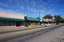
Scottsville is a city in Harrison County, Texas, United States. The population was 376 at the 2010 census, up from 263 at the 2000 census. Scottsville's population in 2020 decreased to 334.

References

  1. R., DAVIS, STEVEN (June 15, 2010). "RAINS COUNTY". www.tshaonline.org. Retrieved July 29, 2018.{{cite web}}: CS1 maint: multiple names: authors list (link)
  2. "Rains County, Texas". United States Census Bureau . Retrieved January 30, 2022.
  3. "Find a County". National Association of Counties. Retrieved June 7, 2011.
  4. "Rains County - Emory, Rains County, Texas". Recorded Texas Historic Landmark. William Nienke, Sam Morrow. Archived from the original on July 7, 2011. Retrieved February 19, 2011.
  5. "2010 Census Gazetteer Files". United States Census Bureau. August 22, 2012. Retrieved May 9, 2015.
  6. "Decennial Census of Population and Housing by Decades". US Census Bureau.
  7. "Texas Almanac: Population History of Counties from 1850–2010" (PDF). Texas Almanac. Archived (PDF) from the original on October 9, 2022. Retrieved May 9, 2015.
  8. 1 2 3 "P2 HISPANIC OR LATINO, AND NOT HISPANIC OR LATINO BY RACE - 2020: DEC Redistricting Data (PL 94-171) - Rains County, Texas". United States Census Bureau .
  9. "P2 HISPANIC OR LATINO, AND NOT HISPANIC OR LATINO BY RACE - 2010: DEC Redistricting Data (PL 94-171) - Rains County, Texas". United States Census Bureau .
  10. "U.S. Census website". United States Census Bureau . Retrieved May 14, 2011.
  11. Leip, David. "Dave Leip's Atlas of U.S. Presidential Elections". uselectionatlas.org. Retrieved July 29, 2018.

Commons-logo.svg Media related to Rains County, Texas at Wikimedia Commons

32°52′N95°48′W / 32.87°N 95.80°W / 32.87; -95.80