Concho County | |
---|---|
Coordinates: 31°20′N99°52′W / 31.33°N 99.86°W | |
Country | United States |
State | Texas |
Founded | 1879 |
Named for | Concho River |
Seat | Paint Rock |
Largest city | Eden |
Area | |
• Total | 994 sq mi (2,570 km2) |
• Land | 984 sq mi (2,550 km2) |
• Water | 9.9 sq mi (26 km2) 1.0% |
Population (2020) | |
• Total | 3,303 |
• Density | 3.3/sq mi (1.3/km2) |
Time zone | UTC−6 (Central) |
• Summer (DST) | UTC−5 (CDT) |
Congressional district | 11th |
Website | www |
Concho County is a county located on the Edwards Plateau in the U.S. state of Texas. At the 2020 census, the population was 3,303. [1] Its county seat is Paint Rock. [2] The county was founded in 1858 and later organized in 1879. [3] It is named for the Concho River.
In the 1800s, Paleo-Indians lived in the county and left behind archaeological remains of a burned-rock midden. Athabascan-speaking Indians associated with the pre-horse Plains culture live in this part of Texas. Later native inhabitants included Jumano, Tonkawa, Comanche and Lipan Apache. [4]
In 1847, John O. Meusebach sent surveyors into the area. In 1849, Robert Simpson Neighbors led a small expedition through the area. [4]
The Texas Legislature formed Concho County from Bexar County in 1858. [4]
In 1874, Ranald S. Mackenzie led a campaign to drive out the remaining native peoples and established the Mackenzie Trail. [4] The county seat was formally established and named Paint Rock after the nearby pictographs. [5] The Eden community was established in 1882. [6] In 1909, the community of Lowake was established. [7]
Railroads came to the county first in 1910, with the Concho, San Saba and Llano Valley railroad being completed to Paint Rock. The Fort Worth and Rio Grande Railway was completed across the southeastern corner of the county in 1911, and the Gulf, Colorado and Santa Fe railroad finished a line to Eden in 1912. [4]
By 1930, the area had 449 owner-operated farms and 682 tenant-operated farms, of whom 619 were sharecroppers. [4]
In 1940, Concho County became part of a soil-conservation district. [4] In 1985, the Texas Water Commission granted permission to impound 554,000 acre-feet (683,000,000 m3) of water on the Colorado River at Stacy, to create the O. H. Ivie Reservoir. [8]
In 1988, Concho County was the leading sheep-producing county in Texas. [4]
According to the U.S. Census Bureau, the county has a total area of 994 square miles (2,570 km2), of which 984 square miles (2,550 km2) is land and 9.9 square miles (26 km2) (1.0%) is water. [9]
Census | Pop. | Note | %± |
---|---|---|---|
1880 | 800 | — | |
1890 | 1,065 | 33.1% | |
1900 | 1,427 | 34.0% | |
1910 | 6,654 | 366.3% | |
1920 | 5,847 | −12.1% | |
1930 | 7,645 | 30.8% | |
1940 | 6,192 | −19.0% | |
1950 | 5,078 | −18.0% | |
1960 | 3,672 | −27.7% | |
1970 | 2,937 | −20.0% | |
1980 | 2,915 | −0.7% | |
1990 | 3,044 | 4.4% | |
2000 | 3,966 | 30.3% | |
2010 | 4,087 | 3.1% | |
2020 | 3,303 | −19.2% | |
U.S. Decennial Census [10] 1850–2010 [11] 2010 [12] 2020 [13] |
Race / Ethnicity | Pop 2010 [12] | Pop 2020 [13] | % 2010 | % 2020 |
---|---|---|---|---|
White alone (NH) | 1,810 | 2,097 | 44.29% | 63.49% |
Black or African American alone (NH) | 57 | 69 | 1.39% | 2.09% |
Native American or Alaska Native alone (NH) | 13 | 9 | 0.32% | 0.27% |
Asian alone (NH) | 14 | 19 | 0.34% | 0.58% |
Pacific Islander alone (NH) | 5 | 1 | 0.12% | 0.03% |
Some Other Race alone (NH) | 2 | 16 | 0.05% | 0.48% |
Mixed Race/Multi-Racial (NH) | 13 | 59 | 0.32% | 1.79% |
Hispanic or Latino (any race) | 2,173 | 1,033 | 53.17% | 31.27% |
Total | 4,087 | 3,303 | 100.00% | 100.00% |
Note: the US Census treats Hispanic/Latino as an ethnic category. This table excludes Latinos from the racial categories and assigns them to a separate category. Hispanics/Latinos can be of any race.
At the 2000[ needs update ] census, [14] 3,966 people, 1,058 households and 757 families resided in the county. The population density was 4 per square mile (1.5/km2). There were 1,488 housing units at an average density of 2 per square mile (0.77/km2). The racial make-up of the county was 88.20% White, 0.98% Black or African American, 0.48% Native American, 0.08% Asian, 0.10% Pacific Islander, 8.93% from other races and 1.24% from two or more races. About 41.33% of the population were Hispanics or Latinos of any race.
Of the 1,058 households, 29.80% had children under the age of 18 living with them, 59.40% were married couples living together, 9.70% had a female householder with no husband present and 28.40% were not families. About 26.60% of all households were made up of individuals and 14.20% had someone living alone who was 65 years of age or older. The average household size was 2.45 and the average family size was 2.97.
16.10% of the population were under the age of 18, 10.40% from 18 to 24, 38.20% from 25 to 44, 21.50% from 45 to 64 and 13.80% were 65 years of age or older. The median age was 36 years. For every 100 females, there were 181.30 males. For every 100 females age 18 and over, there were 209.90 males.
The median household income was $31,313 and the median family income was $36,894. Males had a median income of $20,750 and females $21,458. The per capita income was $15,727. About 7.50% of families and 11.90% of the population were below the poverty line, including 15.80% of those under age 18 and 14.20% of those age 65 or over.
In 2004,[ needs update ] Concho County has the third-highest proportion of prison inmates amongst its residents of any county equivalent in the United States, behind Crowley County, Colorado, and West Feliciana Parish, Louisiana. [15] As a result, the county had the highest gender ratio in the United States with 232 men to every 100 women. [16]
The 1968 movie Journey to Shiloh features a group known as the "Concho County Comanches," and mentions neighboring Menard County.
This section needs expansion. You can help by adding to it. (March 2023) |
Year | Republican | Democratic | Third party | |||
---|---|---|---|---|---|---|
No. | % | No. | % | No. | % | |
2020 | 1,058 | 83.44% | 197 | 15.54% | 13 | 1.03% |
2016 | 885 | 82.87% | 148 | 13.86% | 35 | 3.28% |
2012 | 793 | 79.22% | 194 | 19.38% | 14 | 1.40% |
2008 | 807 | 74.93% | 257 | 23.86% | 13 | 1.21% |
2004 | 911 | 76.36% | 270 | 22.63% | 12 | 1.01% |
2000 | 818 | 74.16% | 268 | 24.30% | 17 | 1.54% |
1996 | 488 | 47.29% | 434 | 42.05% | 110 | 10.66% |
1992 | 414 | 33.50% | 489 | 39.56% | 333 | 26.94% |
1988 | 617 | 48.85% | 643 | 50.91% | 3 | 0.24% |
1984 | 821 | 58.31% | 580 | 41.19% | 7 | 0.50% |
1980 | 700 | 49.40% | 702 | 49.54% | 15 | 1.06% |
1976 | 474 | 39.67% | 715 | 59.83% | 6 | 0.50% |
1972 | 709 | 66.95% | 350 | 33.05% | 0 | 0.00% |
1968 | 411 | 37.03% | 502 | 45.23% | 197 | 17.75% |
1964 | 307 | 24.44% | 948 | 75.48% | 1 | 0.08% |
1960 | 522 | 42.03% | 718 | 57.81% | 2 | 0.16% |
1956 | 574 | 50.26% | 567 | 49.65% | 1 | 0.09% |
1952 | 808 | 53.30% | 708 | 46.70% | 0 | 0.00% |
1948 | 174 | 12.93% | 1,156 | 85.88% | 16 | 1.19% |
1944 | 151 | 11.07% | 1,090 | 79.91% | 123 | 9.02% |
1940 | 189 | 12.60% | 1,310 | 87.33% | 1 | 0.07% |
1936 | 76 | 6.52% | 1,089 | 93.48% | 0 | 0.00% |
1932 | 44 | 3.75% | 1,126 | 95.91% | 4 | 0.34% |
1928 | 446 | 50.97% | 426 | 48.69% | 3 | 0.34% |
1924 | 90 | 11.52% | 668 | 85.53% | 23 | 2.94% |
1920 | 151 | 22.37% | 405 | 60.00% | 119 | 17.63% |
1916 | 36 | 7.07% | 418 | 82.12% | 55 | 10.81% |
1912 | 16 | 4.28% | 326 | 87.17% | 32 | 8.56% |
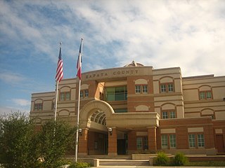
Zapata County is a county located in the U.S. state of Texas. As of the 2020 census, its population was 13,889. Its county seat is Zapata. The county is east of the Mexico–United States border and is named for Colonel José Antonio de Zapata, a rancher in the area who rebelled against Mexico.
Wheeler County is a county located in the U.S. state of Texas. As of the 2020 census, its population was 4,990. Its county seat is Wheeler. The county was formed in 1876 and organized in 1879. It is named for Royall Tyler Wheeler, a chief justice of the Texas Supreme Court.
Tyler County is a county located in the U.S. state of Texas. It is in East Texas and its seat is Woodville.
Trinity County is a county located in the U.S. state of Texas. As of the 2020 census, the population was 13,602. Its county seat is Groveton. The county is named for the Trinity River.
Tom Green County is a county located on the Edwards Plateau in the U.S. state of Texas. As of the 2020 census, its population was 120,003. Its county seat is San Angelo. The county was created in 1874 and organized the following year. It is named for Thomas Green, who was a Confederate soldier and lawyer. Tom Green County is included in the San Angelo metropolitan statistical area; the county is home to Goodfellow Air Force Base, as well as Angelo State University, part of the Texas Tech University System.
Sherman County is a county located in the U.S. state of Texas. As of the 2020 census, its population was 2,782. Its county seat is Stratford. The county was created in 1876 and organized in 1889. It is named for Sidney Sherman, who fought in the Texas Revolution. Though both Sherman County and Sherman, Texas, are named for the same person, the city of Sherman is located in Grayson County, about 430 miles to the southeast.
San Jacinto County is a county in the U.S. state of Texas. As of the 2020 census, its population was 27,402. Its county seat is Coldspring. The county's name comes from the Battle of San Jacinto which secured Texas' independence from Mexico and established a republic in 1836.
Morris County is a county located near the eastern border of the U.S. state of Texas. As of the 2020 census, its population was 11,973. Its county seat is Daingerfield. Morris County is probably named for William Wright Morris, an early judge and planter from Henderson, also in northeast Texas. As of 2016, Morris County is no longer one of six entirely dry, prohibition counties in the state of Texas. Morris County is "partially wet."
Menard County is a county located on the Edwards Plateau in the U.S. state of Texas. As of the 2020 census, its population was 1,962. The county seat is Menard. The county was created in 1858 and later organized in 1871. It is named for Michel Branamour Menard, the founder of Galveston, Texas.
Martin County is a county in the U.S. state of Texas. As of the 2020 census, its population was 5,237. Its county seat is Stanton. The county was created in 1876 and organized in 1884. It is named for Wylie Martin, an early settler.
Jackson County is a county in the U.S. state of Texas. As of the 2020 census its population was 14,988. Its county seat is Edna. The county was created in 1835 as a municipality in Mexico and in 1836 was organized as a county. It is named for Andrew Jackson, President of the United States from 1829 to 1837.
Haskell County is a county located in the U.S. state of Texas. As of the 2020 census, its population was 5,416. The county seat is Haskell. The county was created in 1858 and later organized in 1885. It is named for Charles Ready Haskell, who was killed in the Goliad massacre.
Hartley County is a county located in the U.S. state of Texas. As of the 2020 census, its population was 5,382. The county seat is Channing. The county was created in 1876 and later organized in 1891. It is named for Oliver C. Hartley and his brother, Rufus K. Hartley, two early Texas legislators and lawyers.
Dallam County is the north-westernmost county in the U.S. state of Texas. As of the 2020 Census, its population was 7,115. Its county seat is Dalhart. The county was founded in 1876 and later organized in 1891. It is named for James Wilmer Dallam, a lawyer and newspaper publisher.
Coleman County is a county located in the U.S. state of Texas. As of the 2020 census, its population was 7,684. The county seat is Coleman. The county was founded in 1858 and organized in 1864. It is named for Robert M. Coleman, a signer of the Texas Declaration of Independence and soldier at the Battle of San Jacinto.
Cochran County is a county located in the U.S. state of Texas. As of the 2020 census, its population was 2,547. The county seat is Morton. The county was created in 1876 and later organized in 1924. It is named for Robert E. Cochran, a defender of the Alamo.
Panhandle is the county seat of Carson County, Texas, United States. The population of the town was 2,452 at the 2010 census. Panhandle is part of the Amarillo metropolitan statistical area.
Eden is a city in Concho County, Texas, United States. The population was 2,766 at the 2010 census. The community is a rural trading center for agricultural products for the many large ranches and farms in West Texas.
Paint Rock is a town in and the county seat of Concho County, Texas, United States. The population was 237 at the 2020 census.
Runnels County is a county located in the U.S. state of Texas. As of the 2020 census, its population was 9,900. Its county seat is Ballinger. The county was created in 1858 and later organized in 1880. It is named for Hiram G. Runnels, a Texas state legislator.
Media related to Concho County, Texas at Wikimedia Commons