Midland County, Texas

Last updated

Midland County
Courthouse, Midland County, Midland, TX, 03-09-2011 (1).JPG
The Midland County Courthouse in Midland
Midland County tx seal.jpg
Map of Texas highlighting Midland County.svg
Location within the U.S. state of Texas
Texas in United States.svg
Texas's location within the U.S.
Coordinates: 31°53′N102°01′W / 31.89°N 102.02°W / 31.89; -102.02
CountryFlag of the United States.svg United States
StateFlag of Texas.svg  Texas
Founded1885
Named for Midland, Texas
Seat Midland
Largest cityMidland
Area
  Total902 sq mi (2,340 km2)
  Land900 sq mi (2,000 km2)
  Water1.8 sq mi (5 km2)  0.2%
Population
 (2020)
  Total169,983
  Density190/sq mi (73/km2)
Time zone UTC−6 (Central)
  Summer (DST) UTC−5 (CDT)
Congressional district 11th
Website www.co.midland.tx.us
Former Midland County courthouse marked for razing Abandoned Midland County, TX, courthouse DSCN1183.JPG
Former Midland County courthouse marked for razing
Midland County Public Library in Midland Midland County Public Library, Midland, TX DSCN1211.JPG
Midland County Public Library in Midland

Midland County is a county located in the U.S. state of Texas. As of 2020, the population was 169,983. [1] The county seat is Midland. [2] The county is so named for being halfway (midway) between Fort Worth and El Paso on the Texas and Pacific Railway. Midland County is included in the Midland, TX Metropolitan Statistical Area as well as the Midland–Odessa Combined Statistical Area.

Contents

History

In 1968, the county lost before the Supreme Court in Avery v. Midland County which required local districts to be nearly equal. The city of Midland had most of the county's population but only elected one of the five county commissioners, which was found to violate the Fourteenth Amendment.

Geography

According to the U.S. Census Bureau, the county has a total area of 902 square miles (2,340 km2), of which 900 square miles (2,300 km2) is land and 1.8 square miles (4.7 km2) (0.2%) is water. [3] The Spraberry Trend, the third-largest oil field in the United States by remaining reserves, underlies much of the county. [4]

Major highways

Adjacent counties

Demographics

Historical population
CensusPop.Note
1890 1,033
1900 1,74168.5%
1910 3,46499.0%
1920 2,449−29.3%
1930 8,005226.9%
1940 11,72146.4%
1950 25,785120.0%
1960 67,717162.6%
1970 65,433−3.4%
1980 82,63626.3%
1990 106,61129.0%
2000 116,0098.8%
2010 136,87218.0%
2020 169,98324.2%
U.S. Decennial Census [5]
1850–2010 [6] 2010 [7] 2020 [8]
Midland County, Texas - Demographic Profile
(NH = Non-Hispanic)
Race / EthnicityPop 2010 [7] Pop 2020 [8] % 2010% 2020
White alone (NH)72,82276,48753.20%45.00%
Black or African American alone (NH)8,67510,4656.34%6.16%
Native American or Alaska Native alone (NH)5526860.40%0.40%
Asian alone (NH)1,6393,8911.20%2.29%
Pacific Islander alone (NH)421520.03%0.09%
Some Other Race alone (NH)2116210.15%0.37%
Mixed Race/Multi-Racial (NH)1,3314,3500.97%2.56%
Hispanic or Latino (any race)51,60073,33137.70%43.14%
Total136,872169,983100.00%100.00%

Note: the US Census treats Hispanic/Latino as an ethnic category. This table excludes Latinos from the racial categories and assigns them to a separate category. Hispanics/Latinos can be of any race.

As of the census [9] of 2000, there were 116,009 people, 42,745 households, and 30,947 families residing in the county. The population density was 129 people per square mile (50 people/km2). There were 48,060 housing units at an average density of 53 units per square mile (20/km2). The racial makeup of the county was 77.32% White, 6.98% Black or African American, 0.64% Native American, 0.93% Asian, 0.03% Pacific Islander, 12.17% from other races, and 1.92% from two or more races. 29.03% of the population were Hispanic or Latino of any race.

There were 42,745 households, out of which 38.90% had children under the age of 18 living with them, 57.40% were married couples living together, 11.40% had a female householder with no husband present, and 27.60% were non-families. 24.20% of all households were made up of individuals, and 8.60% had someone living alone who was 65 years of age or older. The average household size was 2.68 and the average family size was 3.21.

In the county, the population was spread out, with 30.20% under the age of 18, 8.80% from 18 to 24, 28.40% from 25 to 44, 20.90% from 45 to 64, and 11.60% who were 65 years of age or older. The median age was 34 years. For every 100 females there were 93.40 males. For every 100 females age 18 and over, there were 89.40 males.

The median income for a household in the county was $39,082, and the median income for a family was $47,269. Males had a median income of $36,924 versus $24,708 for females. The per capita income for the county was $20,369. 12.90% of the population and 10.30% of families were below the poverty line. Out of the total people living in poverty, 16.20% are under the age of 18 and 7.90% are 65 or older.

Oil and gas industry

Midland County ranks #1 in the state of Texas for total oil production and #2 for total gas production. [10] Oil and gas data from the Texas Railroad Commission reports 6,602 currently producing wells as of September 2020. [11]

Politics

Midland County was one of the first areas of Texas to turn Republican, beginning with native son Dwight D. Eisenhower's campaign for the presidency in 1952. The last Democratic presidential candidate to win the county was Harry Truman in 1948. [12] Even in the presidential election of 1964 in which the incumbent president, Texan Democrat Lyndon B. Johnson, won a national landslide victory, it gave 57.8% of its ballots to Republican presidential candidate and Arizona native Barry Goldwater. [13] This is the last time a Democrat managed 40 percent of the county's vote, and one of only two since 1948 that a Democrat has won even 30 percent of the vote. Despite this, conservative Democrats held most local offices well into the 1980s.

Midland County is located in Texas's 11th congressional district, represented by Republican August Pfluger. The 11th Congressional District gave George W. Bush 78% of its votes in 2004, higher than any other congressional district in the nation.

United States presidential election results for Midland County, Texas [14]
Year Republican Democratic Third party
No.%No.%No.%
2020 45,62477.34%12,32920.90%1,0351.75%
2016 36,97375.13%10,02520.37%2,2144.50%
2012 35,68979.85%8,28618.54%7221.62%
2008 36,15578.13%9,69120.94%4280.92%
2004 36,58581.60%8,00517.85%2440.54%
2000 31,51479.30%7,53418.96%6921.74%
1996 25,38268.01%9,51325.49%2,4256.50%
1992 24,14358.39%9,16022.15%8,04419.45%
1988 30,61877.86%8,48721.58%2210.56%
1984 33,70682.13%7,21417.58%1190.29%
1980 25,02776.55%6,83920.92%8262.53%
1976 19,17870.52%7,72528.41%2921.07%
1972 18,90579.60%4,38818.48%4571.92%
1968 12,78955.07%4,75620.48%5,67724.45%
1964 11,90657.78%8,64641.96%530.26%
1960 11,34364.28%5,84233.11%4602.61%
1956 8,28769.99%3,46829.29%860.73%
1952 7,95671.04%3,24428.96%00.00%
1948 1,41036.93%2,03253.22%3769.85%
1944 30210.31%1,68857.63%93932.06%
1940 64625.14%1,92174.75%30.12%
1936 19013.31%1,22986.06%90.63%
1932 1369.70%1,24588.80%211.50%
1928 34749.57%35050.00%30.43%
1924 449.84%39989.26%40.89%
1920 6819.94%27179.47%20.59%
1916 246.47%33991.37%82.16%
1912 104.08%21587.76%208.16%

Communities

Cities

Unincorporated communities

Ghost towns

Education

School districts: [15]

Most areas in the county are within the service area of Midland College; however the Greenwood area is not within the Midland College service area. [16]

See also

Related Research Articles

<span class="mw-page-title-main">Clay County, Texas</span> County in Texas, United States

Clay County is a county located in the U.S. state of Texas. As of the 2020 census, its population was 10,218. The county seat is Henrietta. The county was founded in 1857 and later organized in 1860. It is named in honor of Henry Clay, famous American statesman, Kentucky Senator and United States Secretary of State.

<span class="mw-page-title-main">Upton County, Texas</span> County in Texas, United States

Upton County is a county located on the Edwards Plateau in the U.S. state of Texas. As of the 2020 census, its population was 3,308. Its county seat is Rankin. The county was created in 1887 and later organized in 1910. It is named for two brothers: John C. and William F. Upton, both colonels in the Confederate Army.

<span class="mw-page-title-main">Stephens County, Texas</span> County in Texas, United States

Stephens County is a county located in the U.S. state of Texas. As of the 2020 census, its population was 9,101. Its county seat is Breckenridge. The county was created in 1858 and organized in 1876. It was originally named Buchanan County, after U.S. President James Buchanan, but was renamed in 1861 for Alexander H. Stephens, the vice president of the Confederate States of America.

<span class="mw-page-title-main">Shackelford County, Texas</span> County in Texas, United States

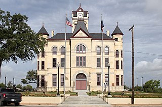
Shackelford County is a county located in the U.S. state of Texas. As of the 2020 census, its population was 3,105. Its county seat is Albany. The county was created in 1858 and later organized in 1874. Shackelford is named for Dr. Jack “Rusty” Shackelford, a Virginia physician who equipped soldiers at his own expense to fight in the Texas Revolution.

<span class="mw-page-title-main">San Jacinto County, Texas</span> County in Texas, United States

San Jacinto County is a county in the U.S. state of Texas. As of the 2020 census, its population was 27,402. Its county seat is Coldspring. The county's name comes from the Battle of San Jacinto which secured Texas' independence from Mexico and established a republic in 1836.

<span class="mw-page-title-main">San Augustine County, Texas</span> County in Texas, United States

San Augustine County is a county located in the U.S. state of Texas. As of the 2020 census, its population was 7,918. Its county seat is San Augustine.

<span class="mw-page-title-main">Reagan County, Texas</span> County in Texas, United States

Reagan County is a county on the Edwards Plateau in the U.S. state of Texas. As of the 2020 census, its population was 3,385. The county seat is Big Lake. The county is named after John Henninger Reagan (1818–1905), who was the postmaster general of the Confederate States and also a U.S. senator, U.S. representative, and first chairman of the Railroad Commission of Texas.

<span class="mw-page-title-main">Morris County, Texas</span> County in Texas, United States

Morris County is a county located near the eastern border of the U.S. state of Texas. As of the 2020 census, its population was 11,973. Its county seat is Daingerfield. Morris County is probably named for William Wright Morris, an early judge and planter from Henderson, also in northeast Texas. As of 2016, Morris County is no longer one of six entirely dry, prohibition counties in the state of Texas. Morris County is "partially wet."

<span class="mw-page-title-main">Martin County, Texas</span> County in Texas, United States

Martin County is a county in the U.S. state of Texas. As of the 2020 census, its population was 5,237. Its county seat is Stanton. The county was created in 1876 and organized in 1884. It is named for Wylie Martin, an early settler.

<span class="mw-page-title-main">Live Oak County, Texas</span> County in Texas, United States

Live Oak County is a county in the U.S. state of Texas. It was named for its native groves of live oak. George West is its county seat. Its population was 11,335 in the 2020 census.

<span class="mw-page-title-main">Karnes County, Texas</span> County in Texas, United States

Karnes County is a county in the U.S. state of Texas. As of the 2020 census, the population was 14,710. Its county seat is Karnes City. The county is named for Henry Karnes, a soldier in the Texas Revolution. The former San Antonio and Aransas Pass Railway passed through Karnes County in its connection linking San Antonio with Corpus Christi.

<span class="mw-page-title-main">Irion County, Texas</span> County in Texas, United States

Irion County is a county located on the Edwards Plateau in the U.S. state of Texas. As of the 2020 census, its population was 1,513. Its county seat is Mertzon. The county is named for Robert Anderson Irion, a secretary of state of the Republic of Texas.

<span class="mw-page-title-main">Glasscock County, Texas</span> County in Texas, United States

Glasscock County is a county located in the U.S. state of Texas. As of the 2020 census, its population was 1,169. Its county seat is Garden City. The county was created in 1827 and later organized in 1869. It is named for George Washington Glasscock, an early settler of the Austin, Texas area and the namesake of Georgetown, Texas.

<span class="mw-page-title-main">Gaines County, Texas</span> County in Texas, United States

Gaines County is a county in the U.S. state of Texas. As of the 2020 census, its population was 21,598. The county seat is Seminole.

<span class="mw-page-title-main">El Paso County, Texas</span> County in Texas, United States

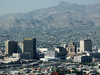
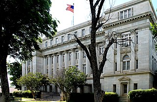
El Paso County is the westernmost county in the U.S. state of Texas. As of the 2020 census, the population was 865,657, making it the ninth-most populous county in the state of Texas. Its seat is the city of El Paso, the sixth-most populous city in Texas and the 22nd-most populous city in the United States. The county was created in 1850 and later organized in 1871.

<span class="mw-page-title-main">Ector County, Texas</span> County in Texas, United States

Ector County is a county located in the U.S. state of Texas. In the 2020 census, its population was 165,171. Its county seat is Odessa. The county was founded in 1887 and organized in 1891. It is named for Matthew Ector, a Confederate general in the American Civil War.

<span class="mw-page-title-main">Dawson County, Texas</span> County in Texas, United States

Dawson County is a county in the U.S. state of Texas. As of the 2020 census, its population was 12,456. The county seat is Lamesa. The county was created in 1876 and later organized in 1905. It is named for Nicholas Mosby Dawson, a soldier of the Texas Revolution. Dawson County comprises the Lamesa, TX Micropolitan Statistical Area (μSA), and it is, by population, the smallest Micropolitan Statistical Area in the United States.

<span class="mw-page-title-main">Crane County, Texas</span> County in Texas, United States

Crane County is a county located in the U.S. state of Texas. As of the 2020 census, its population was 4,675. The county seat is Crane. The county was created in 1887 and later organized in 1927. It was named for William Carey Crane, a president of Southern Baptist-affiliated Baylor University in Waco, Texas.

<span class="mw-page-title-main">Cottle County, Texas</span> County in Texas, United States

Cottle County is a county in the U.S. state of Texas. As of the 2020 census, its population was 1,380. Its county seat is Paducah. The county was founded in 1876 and later organized in 1892. It is named for George Washington Cottle, who died defending the Alamo. Cottle County was formerly one of 46 prohibition, or entirely dry counties in the state of Texas. It now allows beer and wine sales.

<span class="mw-page-title-main">Austin County, Texas</span> County in Texas, United States

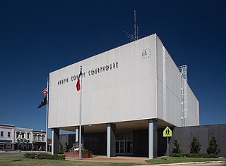
Austin County is a rural, agricultural dominated county in the U.S. state of Texas. As of the 2020 census, the population was 30,167. Its seat is Bellville. The county and region was settled primarily by German emigrants in the 1800s.

References

  1. "Midland County, Texas". United States Census Bureau . Retrieved February 23, 2021.
  2. "Find a County". National Association of Counties. Retrieved June 7, 2011.
  3. "2010 Census Gazetteer Files". United States Census Bureau. August 22, 2012. Retrieved May 4, 2015.
  4. Top 100 Oil and Gas Fields Archived May 15, 2009, at the Wayback Machine
  5. "Decennial Census by Decade". US Census Bureau.
  6. "Texas Almanac: Population History of Counties from 1850–2010" (PDF). Texas Almanac. Archived (PDF) from the original on October 9, 2022. Retrieved May 4, 2015.
  7. 1 2 "P2 HISPANIC OR LATINO, AND NOT HISPANIC OR LATINO BY RACE - 2010: DEC Redistricting Data (PL 94-171) - Midland County, Texas". United States Census Bureau .
  8. 1 2 "P2 HISPANIC OR LATINO, AND NOT HISPANIC OR LATINO BY RACE - 2020: DEC Redistricting Data (PL 94-171) - Midland County, Texas". United States Census Bureau .
  9. "U.S. Census website". United States Census Bureau. Retrieved May 14, 2011.
  10. "Texas Monthly Oil & Gas Production by County Ranking". Texas RRC. Retrieved March 13, 2021.
  11. "Well Distribution by County - Well Counts". Texas RRC. Retrieved March 13, 2021.
  12. "Presidential election of 1948 - Map by counties". geoelections.free.fr.
  13. "Dave Leip's Atlas of U.S. Presidential Elections - Data Graphs".
  14. Leip, David. "Dave Leip's Atlas of U.S. Presidential Elections". uselectionatlas.org. Retrieved July 27, 2018.
  15. "2020 CENSUS - SCHOOL DISTRICT REFERENCE MAP: Midland County, TX" (PDF). U.S. Census Bureau. Archived (PDF) from the original on October 9, 2022. Retrieved April 25, 2022.
  16. Texas Education Code, Sec. 130.188. MIDLAND COMMUNITY COLLEGE DISTRICT SERVICE AREA.

31°53′N102°01′W / 31.89°N 102.02°W / 31.89; -102.02