King County, Texas

Last updated

King County
King County Courthouse August 2020.jpg
King County Courthouse in Guthrie
Map of Texas highlighting King County.svg
Location within the U.S. state of Texas
Texas in United States.svg
Texas's location within the U.S.
Coordinates: 33°37′N100°15′W / 33.61°N 100.25°W / 33.61; -100.25
CountryFlag of the United States.svg United States
StateFlag of Texas.svg  Texas
Founded1891
Named for William Philip King
Seat Guthrie
Largest communityGuthrie
Area
  Total913 sq mi (2,360 km2)
  Land911 sq mi (2,360 km2)
  Water2.5 sq mi (6 km2)  0.3%
Population
 (2020)
  Total265
  Estimate 
(2022)
233 Decrease2.svg
  Density0.29/sq mi (0.11/km2)
Time zone UTC−6 (Central)
  Summer (DST) UTC−5 (CDT)
Congressional district 13th
Website www.kingcountytexas.us

King County is a county located in the U.S. state of Texas. The population was 265 at the 2020 census, [1] making it the second-least populated county in Texas and the third-least populated county in the United States. King County has no incorporated communities. Its county seat is the census-designated place (CDP) of Guthrie. [2] The county was created in 1876 and organized in 1891. [3] It is named for William Philip King, who died at the Battle of the Alamo.

Contents

History

Native Americans

The Apache and Comanche were early tribes in the area. The Red River War of 1874-1875 was a United States Army campaign to force the removal of Natives in Texas and their relocation to reservations, to open the region to white settlers. [4]

County established

On August 21, 1876, the Texas legislature formed King County from Bexar County. By 1880 the United States Census counted forty residents in the county. In 1891, the county was organized. Guthrie was designated as the county seat. [4]

Early ranchers preserved water by damming canyons and draws to hold the heavy spring rains. In the 1890s windmills became the method of water preservation. [5] Some of the earliest settlers were Isom Lynn, A. C. Tackett, Brants Baker, and Bud Arnett. The Four Sixes Ranch was established in 1902 by Samuel Burk Burnett. [6] The formerly-named Pitchfork Land and Cattle Company was organized in 1883, and SMS ranches were established during the same time frame. [7] The 6666 (called Four Sixes Ranch), also founded in 1883, was managed from 1965 to 1986 by George Humphreys, who was also affiliated with the National Ranching Heritage Center in Lubbock.

Dumont was formed in the late 19th century. By that time, farmers began to share the land with ranchers. Cotton was the leading crop for a time, followed by corn, sorghum, and fruit trees. [8]

Oil was discovered in the county in 1943. By January 1, 1991, almost 114,403,000 barrels (18,188,600 m3) of oil had been pumped from King County lands since the first wells were drilled. [4]

Geography

According to the United States Census Bureau, the county has a total area of 913 square miles (2,360 km2), of which 911 square miles (2,360 km2) is land and 2.5 square miles (6.5 km2) (0.3%) is water. [9]

Major highways

Adjacent counties

Demographics

Historical population
CensusPop.Note
1880 40
1890 173332.5%
1900 490183.2%
1910 81065.3%
1920 655−19.1%
1930 1,19382.1%
1940 1,066−10.6%
1950 870−18.4%
1960 640−26.4%
1970 464−27.5%
1980 425−8.4%
1990 354−16.7%
2000 3560.6%
2010 286−19.7%
2020 265−7.3%
2022 (est.)233 [10] −12.1%
=U.S. Decennial Census [11]
1850–2010 [12] 2010-2020 [1]
King County, Texas - Demographic Profile
(NH = Non-Hispanic)
Race / EthnicityPop 2010 [13] Pop 2020 [14] % 2010% 2020
White alone (NH)24223084.62%86.79%
Black or African American alone (NH)000.00%0.00%
Native American or Alaska Native alone (NH)100.35%0.00%
Asian alone (NH)000.00%0.00%
Pacific Islander alone (NH)040.00%1.51%
Some Other Race alone (NH)000.00%0.00%
Mixed Race/Multi-Racial (NH)461.40%2.26%
Hispanic or Latino (any race)392513.64%9.43%
Total286265100.00%100.00%

Note: the US Census treats Hispanic/Latino as an ethnic category. This table excludes Latinos from the racial categories and assigns them to a separate category. Hispanics/Latinos can be of any race.

As of the census [15] of 2000, there were 356 people, 108 households, and 88 families residing in the county. The population density was 0.39 people per square mile (0.15 people/km2). There were 174 housing units at an average density of 0.19 units per square mile (0.073/km2). The racial makeup of the county was 94.10% White, 1.12% Native American, 3.09% from other races, and 1.69% from two or more races. 9.55% of the population were Hispanic or Latino of any race.

There were 108 households, out of which 41.70% had children under the age of 18 living with them, 79.60% were married couples living together, 1.90% had a female householder with no husband present, and 17.60% were non-families. 16.70% of all households were made up of individuals, and 1.90% had someone living alone who was 65 years of age or older. The average household size was 2.77 and the average family size was 3.12.

In the county, the population was spread out, with 33.70% under the age of 18, 3.70% from 18 to 24, 29.50% from 25 to 44, 22.80% from 45 to 64, and 10.40% who were 65 years of age or older. The median age was 37 years. For every 100 females, there were 95.60 males. For every 100 females age 18 and over, there were 100.00 males.

The median income for a household in the county was $35,625, and the median income for a family was $36,875. Males had a median income of $21,389 versus $30,179 for females. The per capita income for the county was $12,321. 20.70% of the population and 17.90% of families were below the poverty line. Out of the total people living in poverty, 23.00% are under the age of 18 and 31.60% are 65 or older.

Politics

King County was once a strongly Democratic county even by Solid South standards. In 1948, 95.85 percent of voters supported Harry S. Truman, [16] in 1960 76.9 percent of voters chose John F. Kennedy [17] and in 1964, 84.1 percent of voters supported Lyndon Johnson. [18] The county also voted for Hubert Humphrey by a plurality in 1968, with 48.7 percent supporting Humphrey while 31.7 percent voted for George Wallace and a mere 19.6 percent voted for Richard Nixon. [19]

However, the county has shifted strongly Republican since the 1980s. The last Democratic presidential nominee to win over twenty percent of the vote in King County was Bill Clinton in 1996. [20] In 2016, by percentage of votes, it was the second most Republican county in the entire country, only being surpassed by Roberts County, Texas.

In the 2004 presidential election, 87.8 percent (137 votes) supported incumbent U.S. President George W. Bush, a Republican, whereas only 11.5 percent (18 votes) backed the Democratic challenger, U.S. Senator John Kerry. [21]

In the 2008 presidential election, 93.2 percent (151 votes) supported the Republican, Senator John McCain, whereas only 4.9 percent (8 votes) backed the Democrat, Senator Barack Obama. Of all United States counties, King had the largest percentage of support for McCain. [22]

In the 2012 presidential election, President Obama fared even worse in King County. His Republican challenger, Mitt Romney, received 139 votes in the county (amounting to 95.9% of the county's total votes in the presidential election), while President Obama received only 5 votes — amounting to 3.4 percent of the total. [23] [24] That percentage was the smallest percentage that President Obama received in any county in the United States in 2012. [24]

In addition, in the 2012 Democratic presidential primaries (in which President Obama faced no serious opposition nationwide), King County was one of two counties that voted for Bob Ely over President Obama. There were only 7 votes cast in the Democratic presidential primary in King County that year. Ely won 4 of them, Obama won 1, and two other minor candidates won 1 each. [25]

In the 2016 presidential election, former Secretary of State Hillary Clinton continued the downward trend. Her Republican challenger, Donald Trump, received 149 votes in the county (93.7% of the county's total votes), while Secretary Clinton received only 5 votes — amounting to 3.1 percent of the total. Libertarian Party candidate Gary Johnson also received 5 votes. [26]

In 2020, Trump did even better, earning 95% of the vote while Joe Biden slightly improved on Clinton's margin, earning eight votes for 5%. There were no votes for third-party candidates. Biden's 5% of the vote was the highest percentage of the vote a Democrat has received in King County since 2004, when John Kerry took 11.5%. Kerry remains the last Democrat to receive at least a double-digit number of votes in the county.

United States presidential election results for King County, Texas [27]
Year Republican Democratic Third party
No.%No.%No.%
2020 15194.97%85.03%00.00%
2016 14993.71%53.14%53.14%
2012 13995.86%53.45%10.69%
2008 15192.64%84.91%42.45%
2004 13787.82%1811.54%10.64%
2000 12087.59%1410.22%32.19%
1996 9753.30%4625.27%3921.43%
1992 7941.80%5428.57%5629.63%
1988 11163.43%6436.57%00.00%
1984 14172.68%5327.32%00.00%
1980 14470.24%5526.83%62.93%
1976 9648.73%10050.76%10.51%
1972 14365.30%7534.25%10.46%
1968 4419.64%10948.66%7131.70%
1964 3415.89%18084.11%00.00%
1960 3922.54%13376.88%10.58%
1956 4620.54%17779.02%10.45%
1952 6625.88%18974.12%00.00%
1948 62.49%23195.85%41.66%
1944 135.08%22889.06%155.86%
1940 237.96%26692.04%00.00%
1936 135.80%21194.20%00.00%
1932 41.75%22498.25%00.00%
1928 8565.38%4534.62%00.00%
1924 44.60%8395.40%00.00%
1920 00.00%15798.13%31.88%
1916 36.00%4794.00%00.00%
1912 22.44%7793.90%33.66%

In the 2012 U.S. Senate election, Republican candidate Ted Cruz received 117 votes (amounting to 95.9% of the county's total vote), while Democratic candidate Paul Sadler received 4 votes, or 3.3 percent of the total. [28]

In the 2014 U.S. Senate election, Republican incumbent Senator John Cornyn received 87 votes (amounting to 96.7% of the county's total vote), while Democratic candidate David Alameel received 1 vote or 1.1 percent of the total. Libertarian Party candidate Rebecca Paddock received 2 votes or 2.2 percent of the total. [29]

In the 2014 Texas gubernatorial election, Republican candidate Greg Abbott received 90 votes (amounting to 96.8% of the county's total vote), while Democratic candidate Wendy Davis received 1 vote or 1.1 percent of the total. Libertarian Party candidate Kathie Glass received 2 votes or 2.2 percent of the total. [30]

Republican James Frank, a businessman from Wichita Falls, has since January 2023 represented King County in the Texas House of Representatives as the representative for House District 69. [31] King County was previously represented by then-Representative (now Senator) Drew Springer, Jr., and briefly by David Spiller after Springer's successful election to the Texas Senate. Republican Charles Perry represents King County and Senate District 28. [32]

Economy

The primary industries are raising beef cattle (since the late 19th century), and oil production (since 1943). Corn and cotton are the leading planted farm crops.

Communities

Education

School districts serving sections of the county include: [33]

The county is in the service area of Vernon College. [34]

See also

Related Research Articles

<span class="mw-page-title-main">Montgomery County, Texas</span> County in Texas, United States

Montgomery County is a county in the U.S. state of Texas. As of the 2020 U.S. census, the county had a population of 620,443. The county seat is Conroe. The county was created by an act of the Congress of the Republic of Texas on December 14, 1837, and is named for the town of Montgomery. Between 2000 and 2010, its population grew by 55%, the 24th-fastest rate of growth of any county in the United States. Between 2010 and 2020, its population grew by 36%. According to the U.S. Census Bureau, the estimated population is 711,354 as of July 1, 2023.

<span class="mw-page-title-main">Roberts County, Texas</span> County in Texas, United States

Roberts County is a county located in the U.S. state of Texas. As of the 2020 census, its population was 827, making it the eighth-least populous county in Texas. Its county seat is Miami, which is also the county's only incorporated community. The county was created in 1876 and organized in 1889. It is named for Oran Milo Roberts, a governor of Texas. Roberts County is one of four prohibition counties in the state of Texas.

<span class="mw-page-title-main">Randall County, Texas</span> County in Texas, United States

Randall County is a county located in the U.S. state of Texas. As of the 2020 census, its population was 140,753. Its county seat is Canyon. The county was created in 1876 and later organized in 1889. It is named for Horace Randal, a Confederate brigadier general killed at the Battle of Jenkins Ferry. The reason the county name differs from his is because the bill creating the county misspelled Randal's name.

<span class="mw-page-title-main">Potter County, Texas</span> County in Texas, United States

Potter County is a county located in the U.S. state of Texas. As of the 2020 census, its population was 118,525. Its county seat is Amarillo. The county was created in 1876 and organized in 1887. It is named for Robert Potter, a politician, signer of the Texas Declaration of Independence, and the Texas Secretary of the Navy. Potter County is included in the Amarillo metropolitan area.

<span class="mw-page-title-main">Nueces County, Texas</span> County in Texas, United States

Nueces County is located in the U.S. state of Texas. As of the 2020 census, the population was 353,178, making it the 16th-most populous county in the state. The county seat is Corpus Christi. The county was formed in 1846 from portions of San Patricio County and organized the following year. It is named for the Nueces River, which marks the county's northwestern boundary with San Patricio County before emptying into its mouth at Nueces Bay north of the port of Corpus Christi. Nueces County is part of the Corpus Christi metropolitan statistical area.

<span class="mw-page-title-main">Newton County, Texas</span> County in Texas, United States

Newton County is the easternmost county in the U.S. state of Texas. As of the 2020 census, its population was 12,217. Its county seat is Newton. The county is named for John Newton, a veteran of the American Revolutionary War.

<span class="mw-page-title-main">Midland County, Texas</span> County in Texas, United States

Midland County is a county located in the U.S. state of Texas. As of 2020, the population was 169,983. The county seat is Midland. The county is so named for being halfway (midway) between Fort Worth and El Paso on the Texas and Pacific Railway. Midland County is included in the Midland, TX Metropolitan Statistical Area as well as the Midland–Odessa Combined Statistical Area.

<span class="mw-page-title-main">Kenedy County, Texas</span> County in Texas, United States

Kenedy County is a county located in the U.S. state of Texas. As of the 2020 census, its population was 350. It is the third-least populous county in Texas and fourth-least populous in the United States. Its county seat is Sarita. The county was created in 1921 from parts of Hidalgo and Willacy counties and is named for Mifflin Kenedy, an early area rancher and steamboat operator.

<span class="mw-page-title-main">Jim Wells County, Texas</span> County in Texas, United States

Jim Wells County is a county in the U.S. state of Texas. As of the 2020 census, its population was 38,891. The county was founded in 1911 and is named for James B. Wells Jr. (1850–1923), for three decades a judge and Democratic Party political boss in South Texas.

<span class="mw-page-title-main">Jack County, Texas</span> County in Texas, United States

Jack County is a county located in the north central part of the U.S. state of Texas. As of the 2020 census, its population was 8,472. Its county seat is Jacksboro. The county was created in 1856 and organized the next year. It is named for Patrick Churchill Jack and his brother William Houston Jack, both soldiers of the Texas Revolution.

<span class="mw-page-title-main">Haskell County, Texas</span> County in Texas, United States

Haskell County is a county located in the U.S. state of Texas. As of the 2020 census, its population was 5,416. The county seat is Haskell. The county was created in 1858 and later organized in 1885. It is named for Charles Ready Haskell, who was killed in the Goliad massacre.

<span class="mw-page-title-main">Gray County, Texas</span> County in Texas, United States

Gray County is a county located in the U.S. state of Texas. As of the 2020 census, its population was 21,227. The county seat is Pampa. The county was created in 1876 and later organized in 1902. is named for Peter W. Gray, a Confederate lawyer and soldier in the American Civil War.

<span class="mw-page-title-main">Glasscock County, Texas</span> County in Texas, United States

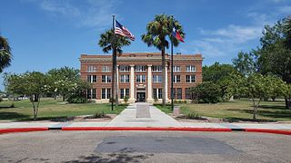
Glasscock County is a county located in the U.S. state of Texas. As of the 2020 census, its population was 1,169. Its county seat is Garden City. The county was created in 1827 and later organized in 1869. It is named for George Washington Glasscock, an early settler of the Austin, Texas area and the namesake of Georgetown, Texas.

<span class="mw-page-title-main">Duval County, Texas</span> County in Texas, United States

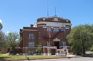
Duval County is a county located in the U.S. state of Texas. As of the 2020 census, its population was 9,831. The county seat is San Diego. The county was founded in 1858 and later organized in 1876. It is named for Burr H. Duval, a soldier in the Texas Revolution who died in the Goliad Massacre.

<span class="mw-page-title-main">Cottle County, Texas</span> County in Texas, United States

Cottle County is a county in the U.S. state of Texas. As of the 2020 census, its population was 1,380. Its county seat is Paducah. The county was founded in 1876 and later organized in 1892. It is named for George Washington Cottle, who died defending the Alamo. Cottle County was formerly one of 46 prohibition, or entirely dry counties in the state of Texas. It now allows beer and wine sales.

<span class="mw-page-title-main">Piscataquis County, Maine</span> County in Maine, United States

Piscataquis County is a county located in the U.S. state of Maine. As of the 2020 census, its population was 16,800, making it Maine's least-populous county. Its county seat is Dover-Foxcroft. The county was incorporated on March 23, 1838, taken from the western part of Penobscot County and the eastern part of Somerset County. It is named for an Abenaki word meaning "branch of the river" or "at the river branch."

<span class="mw-page-title-main">Madison County, Idaho</span> County in Idaho, United States

Madison County is a county located in the U.S. state of Idaho. As of the 2020 census, the population was 52,913. The county seat and largest city is Rexburg.

<span class="mw-page-title-main">Hancock County, Georgia</span> County in Georgia, United States

Hancock County is a county located in the East Central part of the U.S. state of Georgia. As of the 2020 census, the population was 8,735. The county seat is Sparta. The county was created on December 17, 1793, and named for John Hancock, a Founding Father of the American Revolution.

<span class="mw-page-title-main">Madison Parish, Louisiana</span> Parish in Louisiana, United States

Madison Parish is a parish located on the northeastern border of the U.S. state of Louisiana, in the delta lowlands along the Mississippi River. As of the 2020 census, the population was 10,017. Its parish seat is Tallulah. The parish was formed in 1839.

<span class="mw-page-title-main">East Carroll Parish, Louisiana</span> Parish in Louisiana, United States

East Carroll Parish is a parish located in the Mississippi Delta in northeastern Louisiana. As of 2020, its population was 7,459. The parish seat is Lake Providence. An area of cotton plantations in the antebellum era, the parish in the early 21st century has about 74% of its land devoted to agriculture.

References

  1. 1 2 "State & County QuickFacts". United States Census Bureau. Retrieved December 13, 2023.
  2. "Find a County". National Association of Counties. Archived from the original on May 31, 2011. Retrieved June 7, 2011.
  3. "Texas: Individual County Chronologies". Texas Atlas of Historical County Boundaries. The Newberry Library. 2008. Archived from the original on May 13, 2015. Retrieved May 24, 2015.
  4. 1 2 3 Leffler, John (June 15, 2010). "King County, Texas". Handbook of Texas Online. Texas State Historical Association. Retrieved December 13, 2010.
  5. Coppedge, Clay. "Windmills". Texas Escapes. Texas Escapes - Blueprints For Travel, LLC. Retrieved December 13, 2010.
  6. Chiles, Jim (June 1980). "Who Owns Texas". Texas Monthly: 124.
  7. Clayton, Lawrence; Salvant, J U (1997). Historic Ranches of Texas. University of Texas Press. pp. 55–60. ISBN   978-0-292-71189-1.
  8. "Dumont, Texas". Texas Escapes. Texas Escapes - Blueprints For Travel, LLC. Retrieved December 13, 2010.
  9. "2010 Census Gazetteer Files". United States Census Bureau. August 22, 2012. Retrieved May 2, 2015.
  10. "Annual Estimates of the Resident Population for Counties: April 1, 2020 to July 1, 2022". Census.gov . Retrieved December 13, 2023.
  11. "U.S. Decennial Census". United States Census Bureau. Retrieved March 26, 2015.
  12. "Texas Almanac: Population History of Counties from 1850–2010" (PDF). Texas Almanac. Archived (PDF) from the original on October 9, 2022. Retrieved May 2, 2015.
  13. "P2 HISPANIC OR LATINO, AND NOT HISPANIC OR LATINO BY RACE - 2010: DEC Redistricting Data (PL 94-171) - King County, Texas". United States Census Bureau .
  14. "P2 HISPANIC OR LATINO, AND NOT HISPANIC OR LATINO BY RACE - 2020: DEC Redistricting Data (PL 94-171) - King County, Texas". United States Census Bureau .
  15. "U.S. Census website". United States Census Bureau . Retrieved May 14, 2011.
  16. "David Leip's Presidential Election Atlas - 1948 statistics". Uselectionatlas.org. Retrieved November 26, 2012.
  17. "Dave Leip's Atlas of U.S. Presidential Elections - Data Graphs" . Retrieved November 28, 2014.
  18. "Dave Leip's Atlas of U.S. Presidential Elections - Data Graphs" . Retrieved November 28, 2014.
  19. "Dave Leip's Atlas of U.S. Presidential Elections - Data Graphs" . Retrieved November 28, 2014.
  20. "Dave Leip's Atlas of U.S. Presidential Elections - Data Graphs" . Retrieved November 28, 2014.
  21. "Dave Leip's Atlas of U.S. Presidential Elections - Data Graphs" . Retrieved November 28, 2014.
  22. "America's Decision - Election Tracking Map". Fox News. Retrieved November 7, 2008.
  23. 2012 Texas Presidential Election Results, from Politico. Retrieved on November 15, 2012.
  24. 1 2 CNN, Video: Visit the most anti-Obama county in the U.S., from YouTube. RetrievedDecember 4, 2012.
  25. King County Race Summary for the 2012 Democratic presidential primary election, from the Historical Election Results Archived January 9, 2014, at the Wayback Machine section of the website of the Texas Secretary of State. Retrieved on September 18, 2013.
  26. Texas results in the 2016 presidential election, from Politico. Retrieved November 22, 2016.
  27. Leip, David. "Dave Leip's Atlas of U.S. Presidential Elections". uselectionatlas.org. Retrieved July 26, 2018.
  28. "Dave Leip's Atlas of U.S. Presidential Elections - Data Graphs" . Retrieved November 28, 2014.
  29. "Dave Leip's Atlas of U.S. Presidential Elections - Data Graphs" . Retrieved November 28, 2014.
  30. "Dave Leip's Atlas of U.S. Presidential Elections - Data Graphs" . Retrieved November 28, 2014.
  31. "Current Texas House Districts" (PDF).
  32. "Current Texas Senate Districts" (PDF).
  33. "2020 CENSUS - SCHOOL DISTRICT REFERENCE MAP: King County, TX" (PDF). U.S. Census Bureau. Archived (PDF) from the original on October 9, 2022. Retrieved June 29, 2022. - Text list
  34. Texas Education Code, Sec. 130.207. VERNON REGIONAL JUNIOR COLLEGE DISTRICT SERVICE AREA.

33°37′N100°15′W / 33.61°N 100.25°W / 33.61; -100.25